Near-Record Wednesday Gives Way to Fire Concerns (Image Credits: Fox2now.com)
St. Louis – After flirting with record-breaking warmth on Wednesday, the region transitions to a day of showers and potential thunderstorms.[1][2]
Near-Record Wednesday Gives Way to Fire Concerns
Temperatures climbed to 73 degrees Fahrenheit on Wednesday, stopping just short of the daily record of 74 degrees set in 1971. The warm spell heightened fire dangers across the area, prompting officials to strongly discourage outdoor burning. Drier conditions and gusty winds exacerbated the risk, leading to a Red Flag Warning for southern regions.[1][2]
Residents navigated a sunny but hazardous day, with authorities emphasizing caution amid the elevated fire threat. The combination of low humidity, dry ground, and building winds created ideal conditions for rapid fire spread.
Showers Build Westward into Morning Thunder
Rain showers began developing west of St. Louis around 8 a.m. Thursday, marking the start of unsettled weather. These systems pushed eastward, sparking thunderstorms near the metro area between 10 a.m. and noon. Small hail emerged as a possible hazard in these initial storms.[1]
The storms maintained momentum as they crossed the Mississippi River, entering more unstable air over Illinois. Meteorologists tracked the progression closely, noting increased intensity by early afternoon. St. Louis declared Thursday a First Alert Weather Day due to the isolated severe potential.[2]
Severe Threats Target Eastern Illinois Counties
Farther east, storms posed greater dangers, with risks peaking between 1 p.m. and 4 p.m. Counties including Montgomery, Fayette, Bond, and Marion in Illinois faced the highest threats. Winds up to 60 mph, hail the size of quarters, and isolated tornadoes became primary concerns.[1]
The St. Louis metro carried a marginal level 1 out of 5 severe risk, while areas east escalated to level 2. Strong winds dominated the hazards, though hail and rotation remained possible in isolated cells. The main window for impacts spanned 11 a.m. to 6 p.m.[2]
- 60 mph wind gusts in stronger storms
- Quarter-sized hail potential
- Isolated tornado risk, especially east of the river
- Small hail in metro-area thunderstorms
- Red Flag Warning for fire spread in southern areas
Cold Front Brings Sharp Temperature Drop
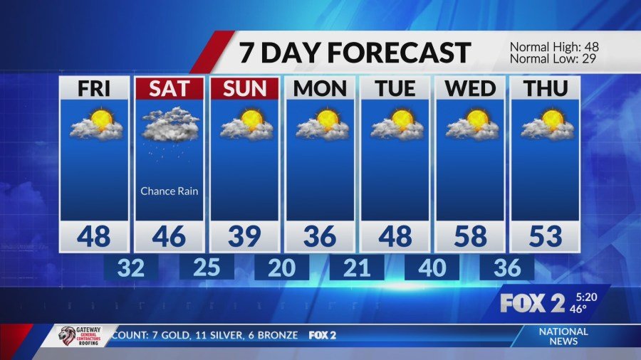
A cold front swept through overnight Thursday, delivering gusty west winds and plummeting temperatures. Mornings dipped into the 30s Friday, with daytime highs struggling to reach the upper 40s. The shift marked a stark contrast to the prior warmth.[1]
Weekend forecasts pointed to sustained chill, as a weak system veered south and minimized precipitation chances. Dry conditions prevailed, though isolated rain-snow mixes posed little travel threat. Winds eased by Friday, stabilizing the cooler pattern.
| Day | High Temp | Key Weather |
|---|---|---|
| Thursday | Mid-60s to 70s | Showers, t-storms, severe east |
| Friday | Upper 40s | Cold, gusty winds |
| Saturday | 40s | Cool, low precip risk |
- Fire danger lingers; avoid outdoor burning.
- Monitor storms east of St. Louis for severe impacts.
- Colder air dominates from Friday onward.
As the front clears out lingering moisture, the region settles into a crisp weekend outlook. Stay prepared for variable conditions and check updates from local sources. What are your plans if storms roll through? Tell us in the comments.