Earth looks calm from a distance, but up close it’s full of places that feel almost wrong, like they belong in a science fiction movie rather than on a familiar blue planet. Some of these geological formations are so strange that even with satellites, supercomputers, and cutting‑edge geology, scientists still argue about how exactly they formed. We have ideas, models, and educated guesses – but not always satisfying answers.
I remember staring at photos of a huge circular structure in the Sahara and thinking it looked like a giant fossilized eye staring back at space. The more you dig into these places, the stranger they become: stones that seem to move on their own, vast spirals of rock in the desert, cliffs that look like they’ve been neatly sliced by a cosmic laser. You can read the scientific explanations, but a little part of your brain still whispers: “Are we sure that’s all there is to it?”
The Eye of the Sahara (Richat Structure, Mauritania)
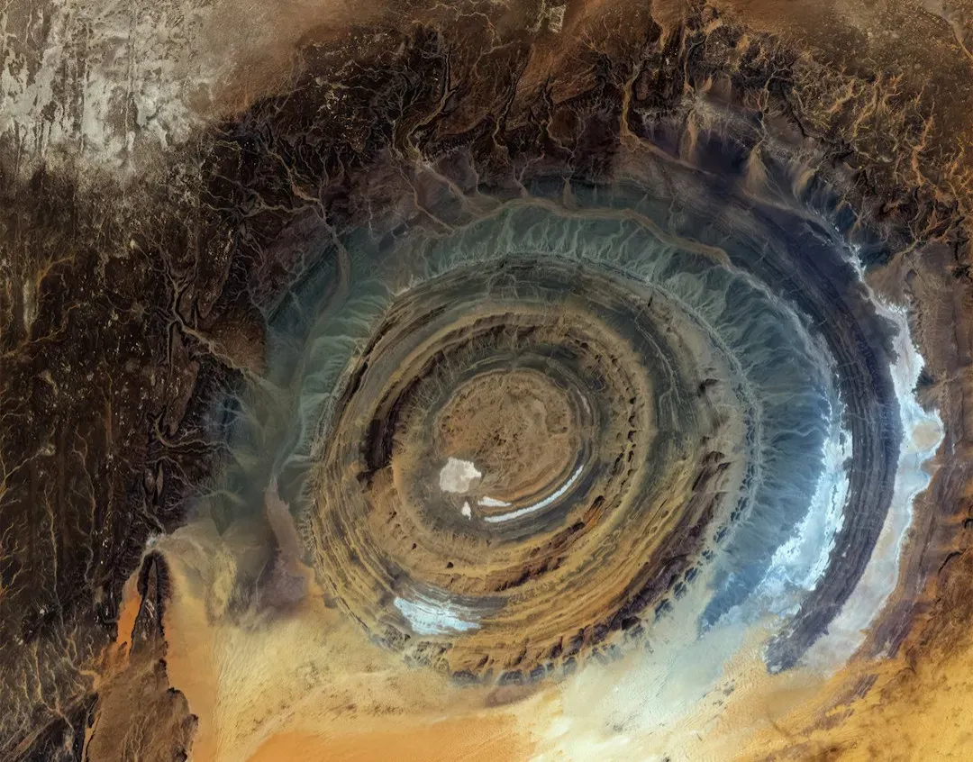
At first glance, the Richat Structure in Mauritania looks man‑made, like some enormous forgotten arena or even the imprint of a crashed spacecraft. It’s a set of nearly perfect concentric rings, more than forty kilometers across, etched into the Sahara Desert and so large it was first really appreciated from space. Early astronauts used it as a landmark, precisely because it looked too organized to be natural. From the ground, though, it’s a maze of eroded rock, cliffs, and valleys that doesn’t feel quite as tidy as satellite images suggest.
Most geologists today think it’s a deeply eroded geological dome, where layers of rock have been lifted and then weathered away in rings. There are volcanic rocks, sedimentary rocks, and signs of long‑term erosion by water and wind. But the nearly circular shape, the symmetry of the rings, and the sheer scale of the structure keep fueling speculation, from ancient cataclysms to wild fringe theories. Even if the basic dome‑and‑erosion idea is correct, the exact sequence of events that sculpted such a clean target shape in the middle of a desert plateau is still not fully nailed down.
The Fairy Circles of Namibia
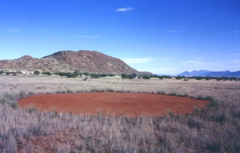
In parts of the Namib Desert, the ground is dotted with tens of thousands of almost perfectly round barren patches, each surrounded by a ring of taller grasses. Seen from above, they look like someone punched polka dots into the desert. The circles can stretch for many kilometers, and they persist for decades, sometimes longer. What’s unsettling is how orderly they appear in such a harsh, chaotic environment, as if some invisible hand laid them out with a ruler.
There are a few main scientific theories, and each one makes sense… until it doesn’t. Some researchers argue that termites subtly engineer the circles, reshaping the soil and controlling vegetation. Others claim they arise from plants competing for scarce water, forming self‑organized patterns as roots push each other away. There are computer models that can recreate the patterns, but they don’t fully capture all the observed details in the field. The reality might be a tangled mix of biology, water physics, and soil processes, but no single explanation has shut down the debate, which is why these circles still feel strangely uncanny.
Sailing Stones of Death Valley, USA
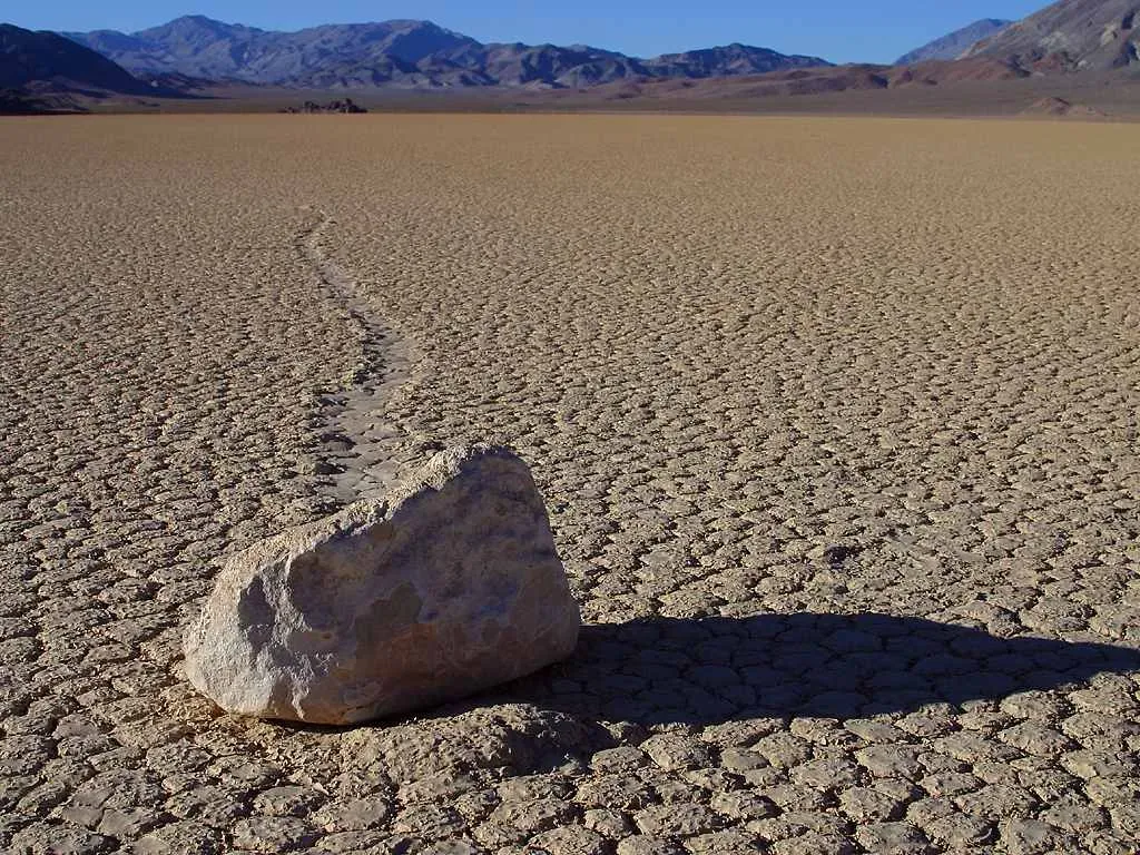
On the dry lake bed of Racetrack Playa in Death Valley, heavy rocks somehow slide silently across the cracked mud, leaving long, curving tracks behind them. For years, there were no witnesses, just the evidence: stones that clearly moved, yet no footprints, no obvious slope, and no visible force. The place practically begged for wild explanations, from magnetic anomalies to supernatural forces. Seeing photos of lonely rocks with long trails feels oddly personal, like someone pressed pause on an invisible event.
Researchers eventually captured time‑lapse evidence of the stones moving, pushed by thin sheets of ice and gentle winds when the playa briefly floods, freezes, then thaws. That combination allows even modest breezes to nudge the rocks along. The explanation sounds neat on paper, but it depends on a delicate choreography of conditions that don’t happen often, and not everyone is fully satisfied that it accounts for every observed track. It’s one of those cases where knowing the likely mechanism doesn’t completely erase the eerie feeling that the rocks have a life of their own.
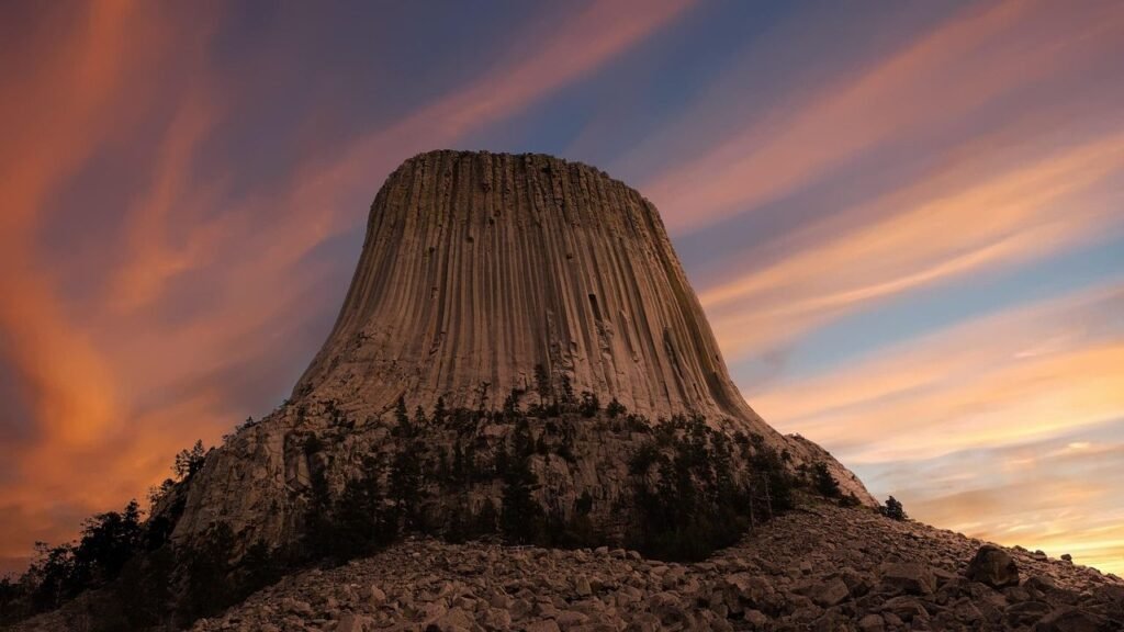
Devils Tower, USA
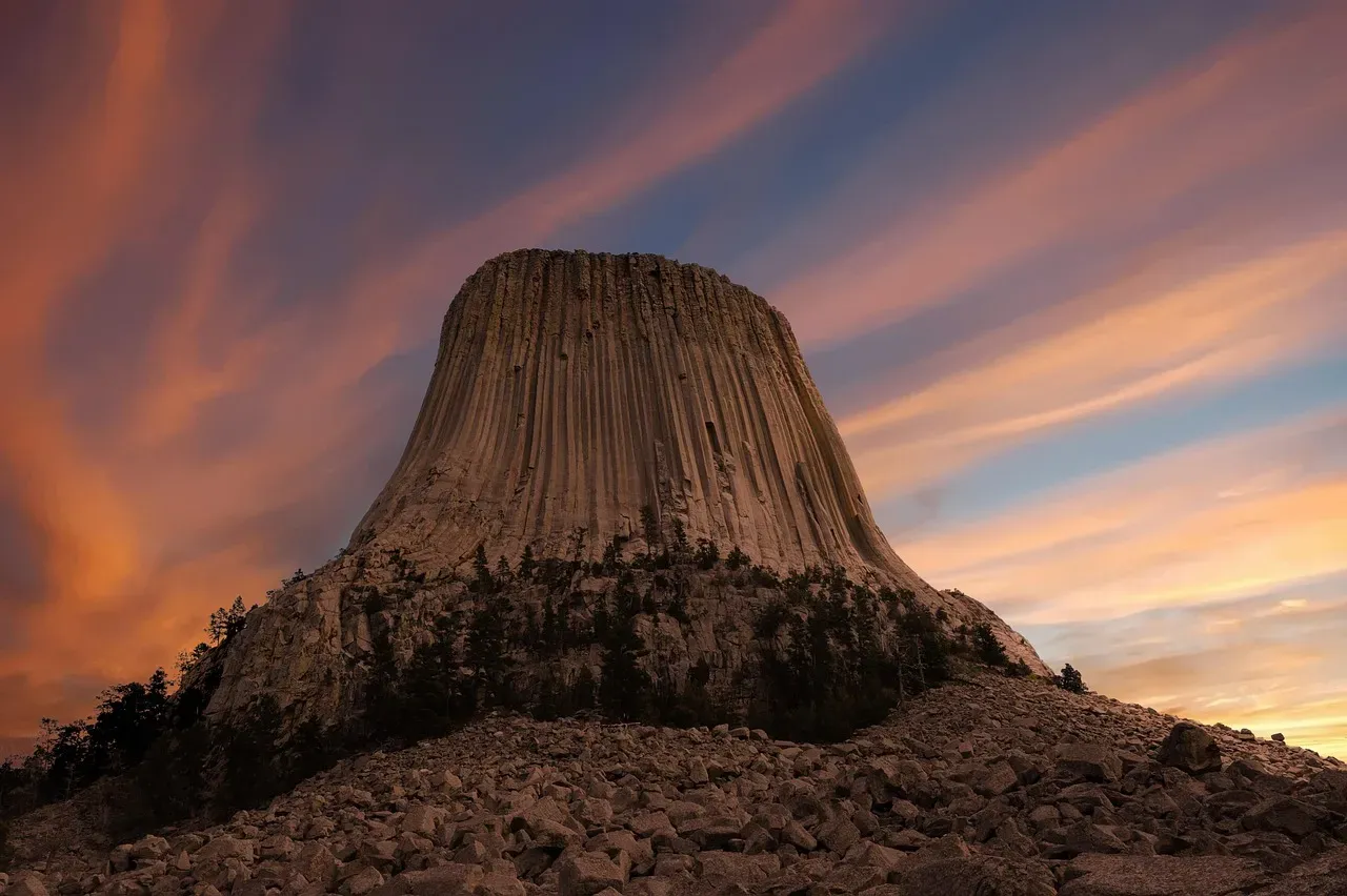
Devils Tower in Wyoming shoots straight out of the ground like a colossal stone tree stump carved into hexagonal columns. It rises more than two hundred meters above the surrounding hills, with sides so steep it looks almost artificial, like an abandoned fortress from a lost civilization. The striking vertical columns are so regular that they make you question whether molten rock and cooling physics alone could really produce something that clean. It’s no surprise that local Indigenous stories and modern pop culture both treat it as a sacred and otherworldly place.
Most geologists agree that Devils Tower began as magma that slowly cooled underground, forming tall columns as it contracted, and was later exposed by erosion. The debates kick in when you ask what exactly it was: a volcanic plug, a laccolith, a different kind of intrusion? The surrounding rock that once embraced it has long since washed away, leaving only the hard, resistant core, so the precise original context is missing. With that evidence gone, we’re left with an impressive monolith, a solid result with an origin story that still has frustrating blank pages.
The Moeraki Boulders, New Zealand
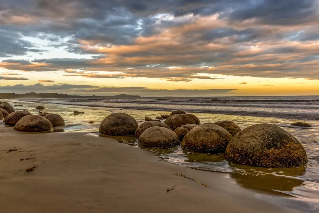
Along Koekohe Beach on New Zealand’s South Island, perfectly spherical boulders sit half‑buried in the sand, like giant marbles abandoned by some bored titan. Many are close to human height, with smooth, rounded surfaces and geometric cracks that give them an almost sculpted appearance. When they break open, the inside reveals complex textures that feel more like seashells or bones than simple stone. Walking among them, it’s hard not to feel like you’re strolling through a museum of natural oddities that forgot to put up the signs.
They are believed to be concretions: mineral nodules that slowly grew within mudstone over millions of years as minerals precipitated around a core. Erosion of the surrounding cliffs released them onto the beach where waves polished them up. That framework is widely accepted, yet the precision of their spherical shapes and the scale of some of them leave room for questions about the exact chemical and environmental conditions needed to make them so regular. In a world where most rocks seem content to be random chunks, these boulders stand out as unnervingly intentional.
The Great Blue Hole, Belize
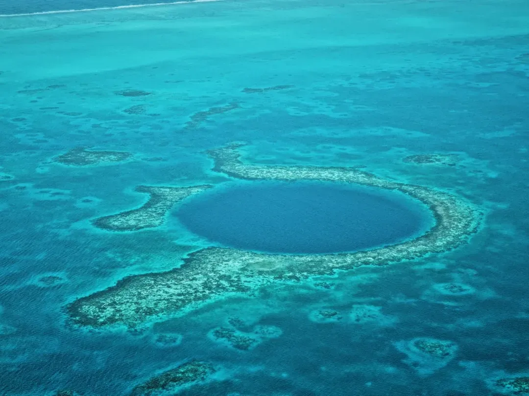
Off the coast of Belize lies a nearly perfect circular pit in the sea, known as the Great Blue Hole. From above, it looks like a dark, bottomless portal punched into the turquoise reef, almost too round and too sharply defined to be natural. Divers dropping down the vertical walls quickly pass from bright tropical blue into deep, eerie darkness. The surrounding reef teems with life, but the interior feels strangely quiet and eerie, like an underwater cathedral where sound gets swallowed.
Geologists classify it as a giant marine sinkhole that likely began as a system of limestone caves formed during lower sea levels in past ice ages, later collapsing and flooding as the ocean rose. Stalactites and other cave features have been found deep inside, reinforcing that story. Still, questions linger about the exact timing of collapses, the stages of flooding, and what the formation reveals about historical sea‑level changes and climate swings. It is both an important natural archive and a visual anomaly that continues to unsettle the imagination every time a new aerial photo goes viral.
The Stone Forest of Shilin, China
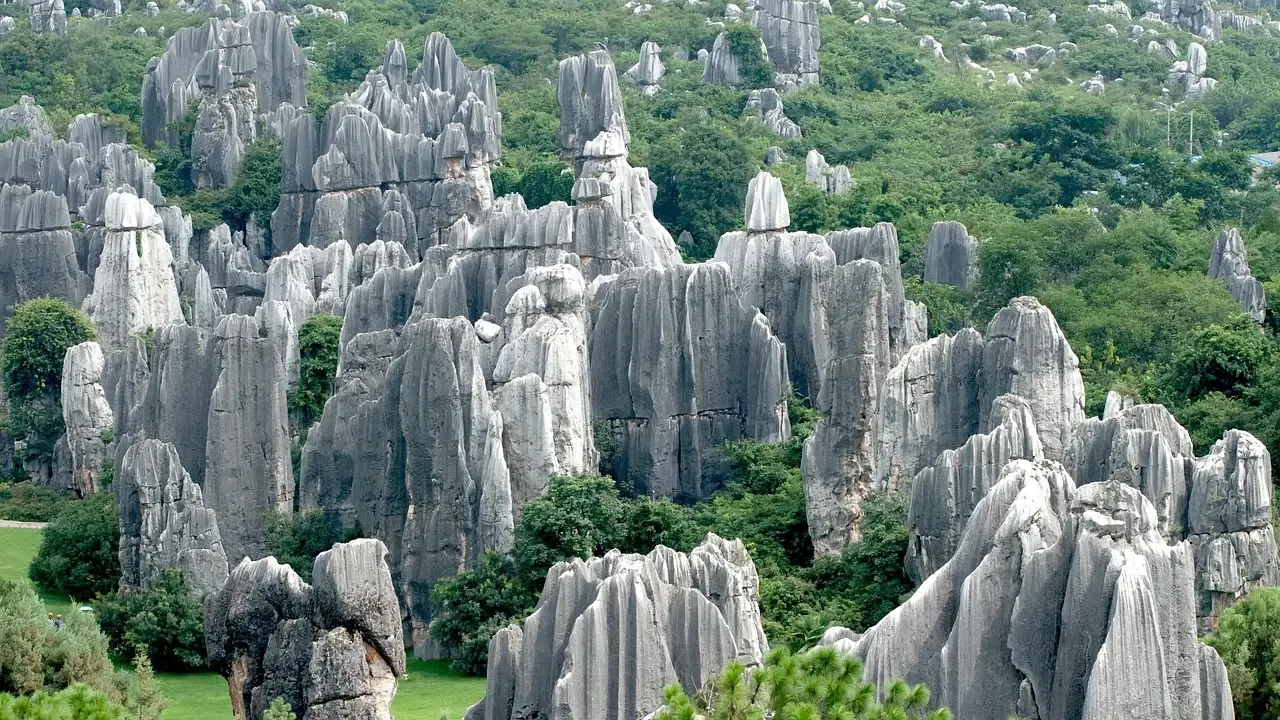
The Stone Forest in Yunnan Province looks like a petrified city, filled with jagged limestone “trees” rising straight out of the ground. From certain angles, the rocks resemble frozen crowds, castle walls, or the spines of enormous buried creatures. The formations extend over a wide area, and walking through them can feel disorienting, as narrow passages twist and dead end without warning. It’s easy to imagine getting lost there centuries ago and deciding the place had to be enchanted, cursed, or both.
Scientifically, the Stone Forest is considered a classic karst landscape, where slightly acidic water has dissolved and sculpted limestone over long timescales. Rain, groundwater, and chemical weathering all play their part, gradually isolating towers and pillars. But not every detail fits neat textbook diagrams, especially when it comes to the variety of shapes and the apparent speed at which some sections have evolved. The big picture of karst is well understood, yet the very specific choreography of uplift, climate, and dissolution that produced such an elaborate stone maze still isn’t mapped out in satisfying detail.
Socotra’s Dragon Blood Trees, Yemen (A Geological‑Biological Odd Couple)
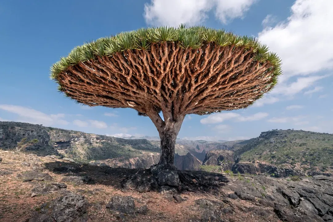
On the island of Socotra, the landscape is dotted with Dragon Blood trees, with umbrella‑shaped canopies and thick trunks that look almost sculpted out of stone. Strictly speaking, they’re biological, not geological, but they sit on a rugged, uplifted plateau of ancient rock that adds to the surreal mood. The plateaus and cliffs of Socotra themselves are the result of continental fragments splitting and shifting, a geological story that left the island isolated both physically and ecologically. The combination of odd rock forms and even stranger trees feels like walking onto an alien set that someone forgot to dismantle.
The rocks of Socotra are part of a rifted margin, shaped by the separation of the Arabian and African plates and later uplift. Yet the timing, uplift rates, and detailed structural evolution of the island’s terrain are still being pieced together from scattered field studies. Meanwhile, the Dragon Blood trees cling to slopes and plateaus, their red resin and bizarre shapes interacting with soils and fractures in ways scientists are still trying to quantify. The whole place is a reminder that geology and biology can intertwine so closely that it’s hard to say where one mystery ends and the other begins.
These formations show that even in an age of high‑resolution maps and powerful models, our planet still keeps a few secrets close to its chest. We can outline the broad strokes of how most of these places probably formed, yet when you zoom in to the fine details – the perfect circles, the sharp boundaries, the improbable shapes – certainty starts to wobble. Standing in front of them, or even just staring at photos, you feel that mix of awe and discomfort that only true mystery can provoke.
Maybe that’s the real gift these strange formations offer: a reminder that the ground under our feet is not fully understood, that Earth is still capable of surprising us in ways that feel almost unsettling. In a world where so much is measured and mapped, it’s oddly comforting to know that some questions remain open, some puzzles still refuse to click into place. When you look at a giant stone “eye” in the desert or a perfect blue circle in the sea, it’s hard not to wonder: how many other impossible‑looking places are still out there, quietly waiting to be found?


