Have you ever glanced up at the sky and witnessed something so bizarre you questioned whether your eyes were playing tricks on you? The atmosphere is filled with secrets. While most of us are familiar with rain, sunshine, and the occasional thunderstorm, there exists a hidden realm of weather phenomena so strange and elusive they continue to puzzle even the most experienced scientists. These aren’t your garden variety clouds or typical lightning strikes.
Some of these events occur in places you’d least expect them. Others appear for mere seconds before vanishing into thin air, leaving witnesses wondering if what they saw was real. The fascinating part is that despite all our technological advances and sophisticated monitoring equipment, meteorologists still scratch their heads trying to fully explain how and why these phenomena occur. Let’s dive into the mysterious world of weather oddities that challenge our understanding of atmospheric science.
Ball Lightning: The Glowing Mystery That Defies Physics
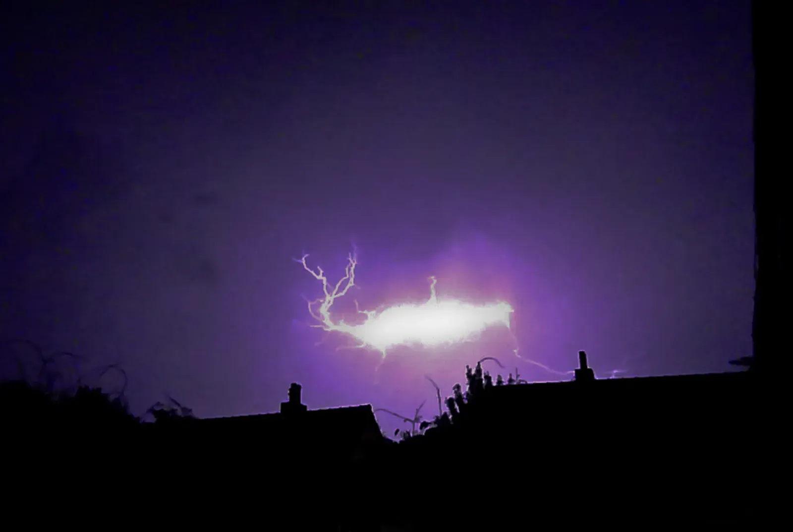
You might encounter luminescent spherical objects that vary from pea-sized to several meters in diameter, and if you’re one of the lucky few who witness this, you’re seeing ball lightning. This bizarre phenomenon usually appears during thunderstorms as a floating sphere that can range in color from blue to orange to yellow, disappearing within a few seconds. What makes this so perplexing is that it behaves nothing like regular lightning.
Scientific data on ball lightning remain scarce, and although laboratory experiments have produced effects that are visually similar to reports of ball lightning, how these relate to the phenomenon remains unclear. Some eyewitness accounts describe these orbs drifting through closed windows, hovering in rooms, and occasionally exploding with a sulfurous smell. Just about five percent of the world’s population has witnessed ball lightning, making it one of nature’s most exclusive shows. Researchers have attempted to recreate it in laboratories, but the real thing continues to elude complete scientific understanding.
Fire Whirls: When Flames Form a Tornado
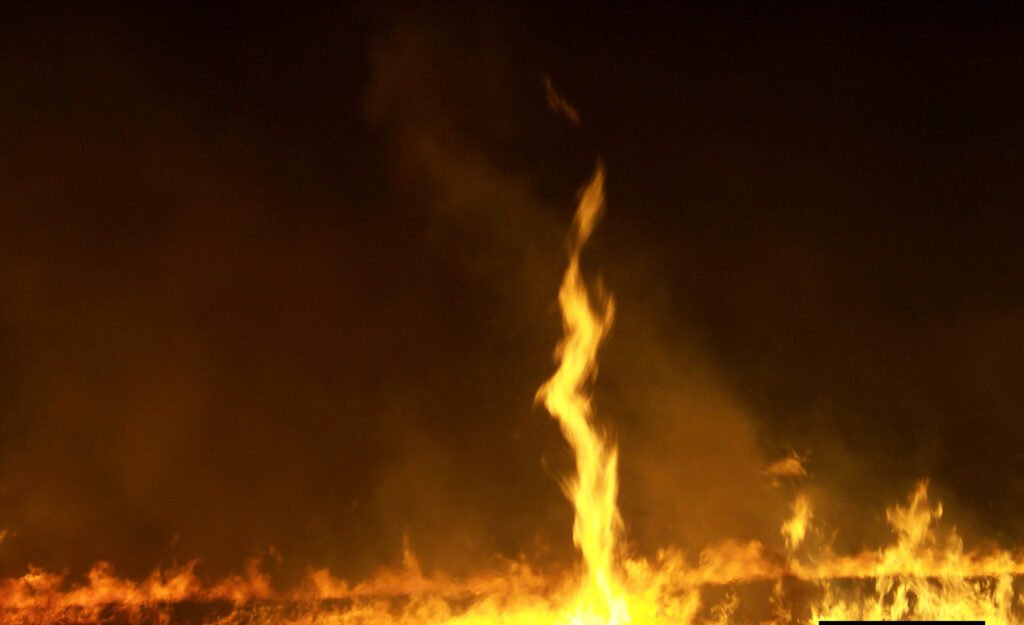
Picture a massive wildfire spinning itself into a towering vortex of flames. A wildfire near Redding, California, produced what was determined to be a fire tornado with winds on par with those of an EF3 tornado, and this event astonished the nation’s meteorologists. These aren’t your typical dust devils with a bit of smoke attached.
Fire whirls, also known as fire tornadoes, are a bizarre and frightening weather phenomenon sometimes encountered by those fighting wildfires, and these rare events are created from the high heats in large fires. The rotating column of flame can reach hundreds of feet into the air with rotational speeds approaching ninety miles per hour. What baffles scientists is the exact atmospheric recipe that transforms an already dangerous wildfire into something that resembles a tornado made entirely of fire. The interaction between intense heat, wind patterns, and atmospheric instability creates these monsters, yet predicting when and where they’ll form remains largely impossible.
Red Rain: When the Sky Bleeds

In Kerala, India, in 2001, a strange red rain shocked residents and baffled scientists. Imagine looking out your window and seeing what appears to be blood falling from the clouds. Initially, locals thought they were witnessing some apocalyptic omen.
Further investigations revealed that the red color was due to spores from a type of algae, yet this explanation only scratches the surface. The phenomenon lasted for several weeks, raising many questions about how such a high concentration of spores could end up in the atmosphere, and some researchers suggested that strong winds carried the spores from distant locations, but the exact process is still not fully understood. What’s particularly strange is the sheer volume of biological material that colored the rain. Scientists still debate how these spores reached such high concentrations and remained suspended in storm clouds before falling. It’s a reminder that sometimes the sky can truly surprise us in the most unsettling ways.
Sprites and Elves: The Secret Light Show Above Thunderstorms
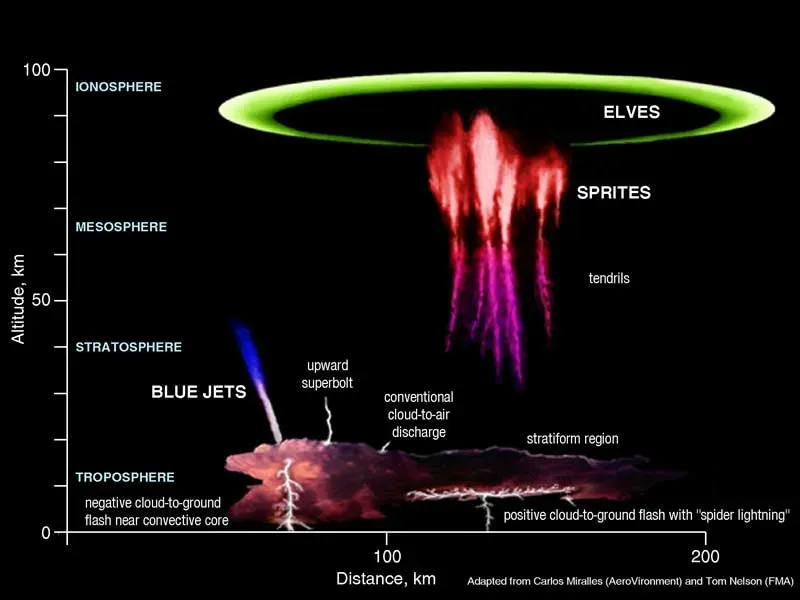
Red sprites are large-scale electrical discharges that occur high above thunderstorm clouds, and unlike regular lightning, which strikes downward, these flashes of red light appear in the upper atmosphere, often above 50 kilometers in altitude. Most people have no idea these exist because they’re nearly impossible to see without looking in exactly the right place at precisely the right moment.
The elusive sprites are rarely photographed as they only last a few milliseconds and occur way up in the mesosphere, and they may be fleeting, but red sprites can reach up to 30 miles high and usually form clusters that resemble jellyfish or carrots. Then there are elves, which are brief expanding halos of light at even higher altitudes. The phenomenon lasts for only a fraction of a second, making it difficult to observe and study, and while scientists believe that sprites are linked to positively charged lightning strikes below, there is still much to learn about the conditions that cause them. These ethereal displays remind us that thunderstorms are far more complex than what we see from the ground.
Morning Glory Clouds: The Rolling Wave in the Sky
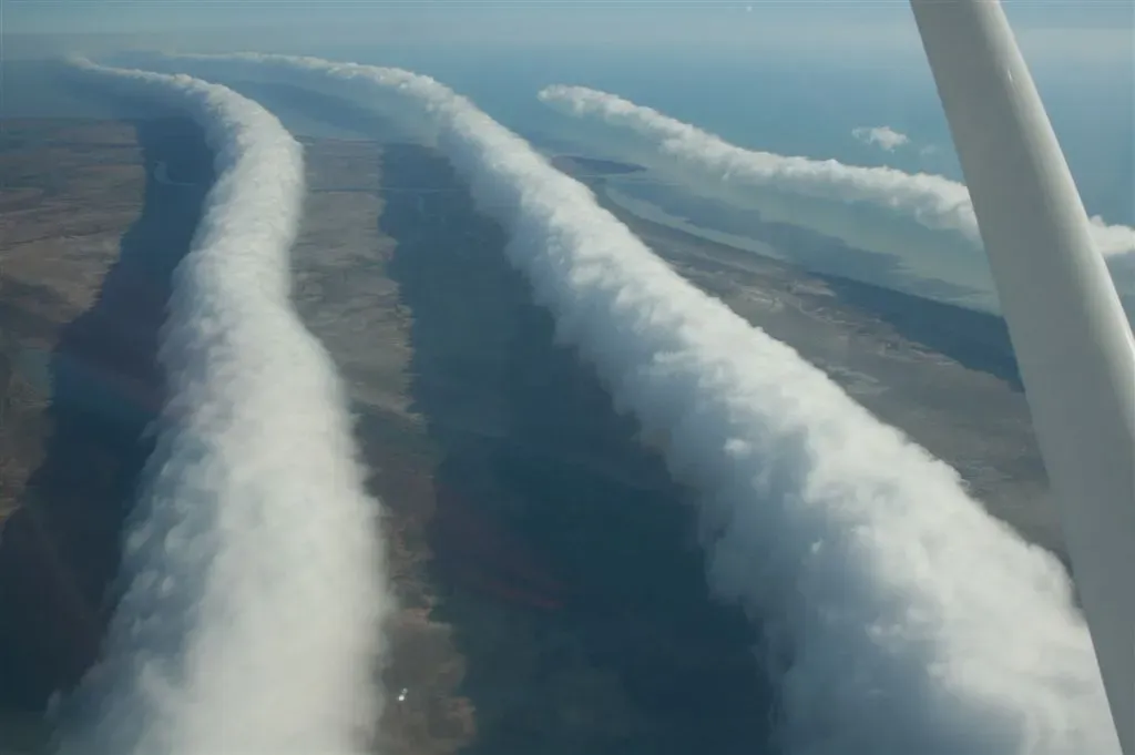
Morning glories resemble elongated roll clouds, and often occur in a series or wave succession, with formations typically spotted during the morning when atmospheric conditions are relatively stable, and morning glory clouds form in the Gulf of Carpentaria region of northeastern Australia. These aren’t your average clouds.
They can stretch for hundreds of miles, rolling across the sky like a slow-motion ocean wave frozen in the atmosphere. Why they are limited to specific regions and seasons continues to puzzle meteorologists. Pilots have been known to fly alongside them for the sheer thrill of gliding on the air currents they create. The conditions needed to form these clouds are so precise that they rarely appear anywhere else on Earth. Honestly, the fact that we can predict their general season but not their exact formation shows just how much mystery still surrounds atmospheric dynamics.
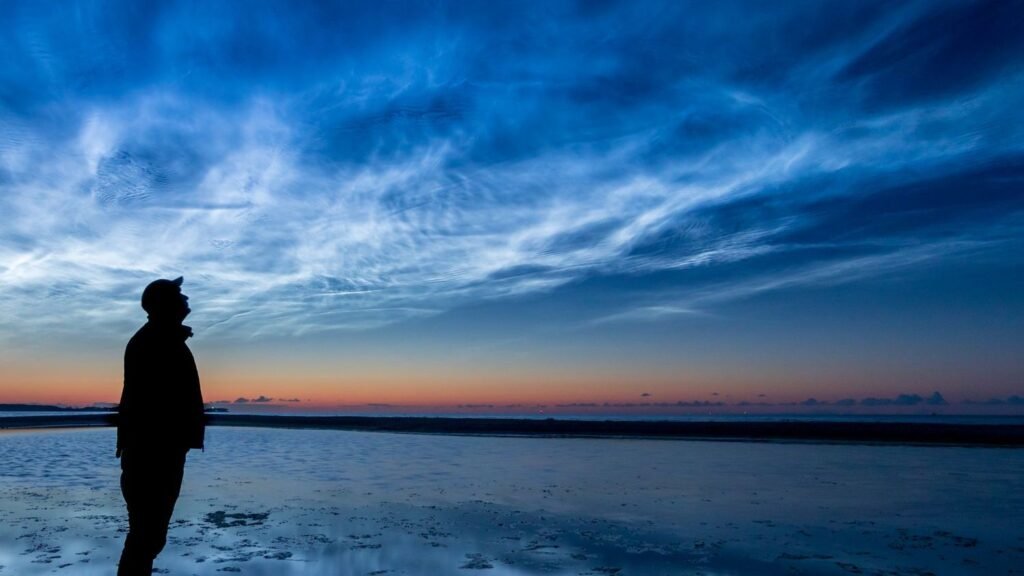
Noctilucent Clouds: The Highest and Most Mysterious Clouds
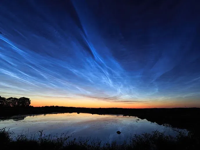
Noctilucent, or night-shining clouds, form far above the weather-producing clouds that we’re used to seeing, some 80 kilometres above Earth’s surface, and noctilucent clouds are composed of ice crystals, which may form on dust from meteorites, and they can generally only be observed in twilight when most of the sky is shrouded in darkness but the sun’s rays can still reach the upper atmosphere to illuminate them from below.
Rare but made more common by climate change, nacreous or noctilucent clouds form from ice crystals and methane at high altitudes, and according to NOAA, it is likely that these weather phenomena did not exist before 1885. Think about that for a second. These clouds might be a relatively new atmospheric feature in human history, possibly linked to changes in our atmosphere. They shimmer with an otherworldly luminescence, appearing like ghostly wisps painted across the twilight sky. Their increasing frequency in recent decades has meteorologists wondering if they’re witnessing a fundamental shift in upper atmospheric conditions.
Heat Bursts: The Sudden Midnight Heatwave
Heat bursts occur in the wake of dying thunderstorms, but other conditions have to be just right, the storm has to be high in the atmosphere and the air beneath must be hot and dry, and when the storm rains into this arid environment, the water quickly evaporates, with evaporation taking heat energy out of the surrounding air and causing it to cool and contract, resulting in a very dense parcel of air too heavy to stay up.
In the case of a heat burst, all of the moisture evaporates and that dense air is only getting warmer as it approaches the ground at high speeds, and when it hits, it suddenly delivers oppressively hot and dry air that can stay in place for hours. Imagine waking up in the middle of a summer night to find the temperature has jumped twenty degrees in minutes. The air feels like someone opened a giant oven door. Most people experiencing this bizarre phenomenon have no idea what’s happening. It feels completely wrong for nighttime temperatures to spike so dramatically, yet it’s a legitimate atmospheric event that continues to surprise both residents and meteorologists when it occurs.
Silent Tornadoes: The Deadly Twisters Without Sound
Meteorologists have found that silent tornadoes often form in areas with unique atmospheric conditions, but they still don’t fully grasp how or why the sound is diminished, and silent tornadoes highlight the complexity of severe weather and the challenges in predicting it, while they are rare, their existence is a stark reminder of the ever-present unpredictability of nature.
Most tornadoes announce their arrival with a freight-train roar that gives people precious seconds to seek shelter. Silent tornadoes rob you of that warning. They spin with the same devastating force but approach with an eerie quietness that makes them exponentially more dangerous. The atmospheric conditions that muffle the sound remain poorly understood. Some theories suggest temperature inversions or specific wind patterns might trap the sound, but no one knows for certain. It’s hard to say for sure, but these silent killers represent one of the most unsettling gaps in our understanding of severe weather.
Conclusion

The atmosphere remains one of the last frontiers of mystery on our planet. Despite satellites, radar systems, and sophisticated computer models, nature continues to produce phenomena that leave meteorologists puzzled. Despite all the advancements in science and technology, there are still many weather phenomena that continue to puzzle experts, from glowing tornadoes to ice circles, these strange occurrences defy complete explanation, leaving researchers with more questions than answers, and some of these events are rare and hard to predict, while others happen in specific regions under unique conditions.
These eight phenomena remind us that we’re still learning about the complex systems that govern our weather. Each mysterious event pushes scientists to question their assumptions and develop new theories. The next time you look up at the sky, remember that you might be one of the lucky few to witness something science can’t yet fully explain. What do you think is the most fascinating of these weather mysteries? Share your thoughts in the comments below.


