You’ve probably seen pictures of breathtaking rock formations scattered across social media. Stunning, yes. Rare, maybe. Still, most geological wonders have siblings somewhere else on the planet. Columnar basalt? Found in dozens of countries. Limestone caves? Practically everywhere.
What if I told you some formations are genuinely one of a kind? These aren’t just pretty rocks or unusual landscapes. They’re singularities, geological accidents that happened once and only once in Earth’s history. No replicas. No variations on the other side of the world. Just one spot where conditions aligned so perfectly that nature created something unrepeatable. Let’s explore ten formations so rare, you’ll find them in only one place on Earth.
The Richat Structure: Mauritania’s Desert Bullseye
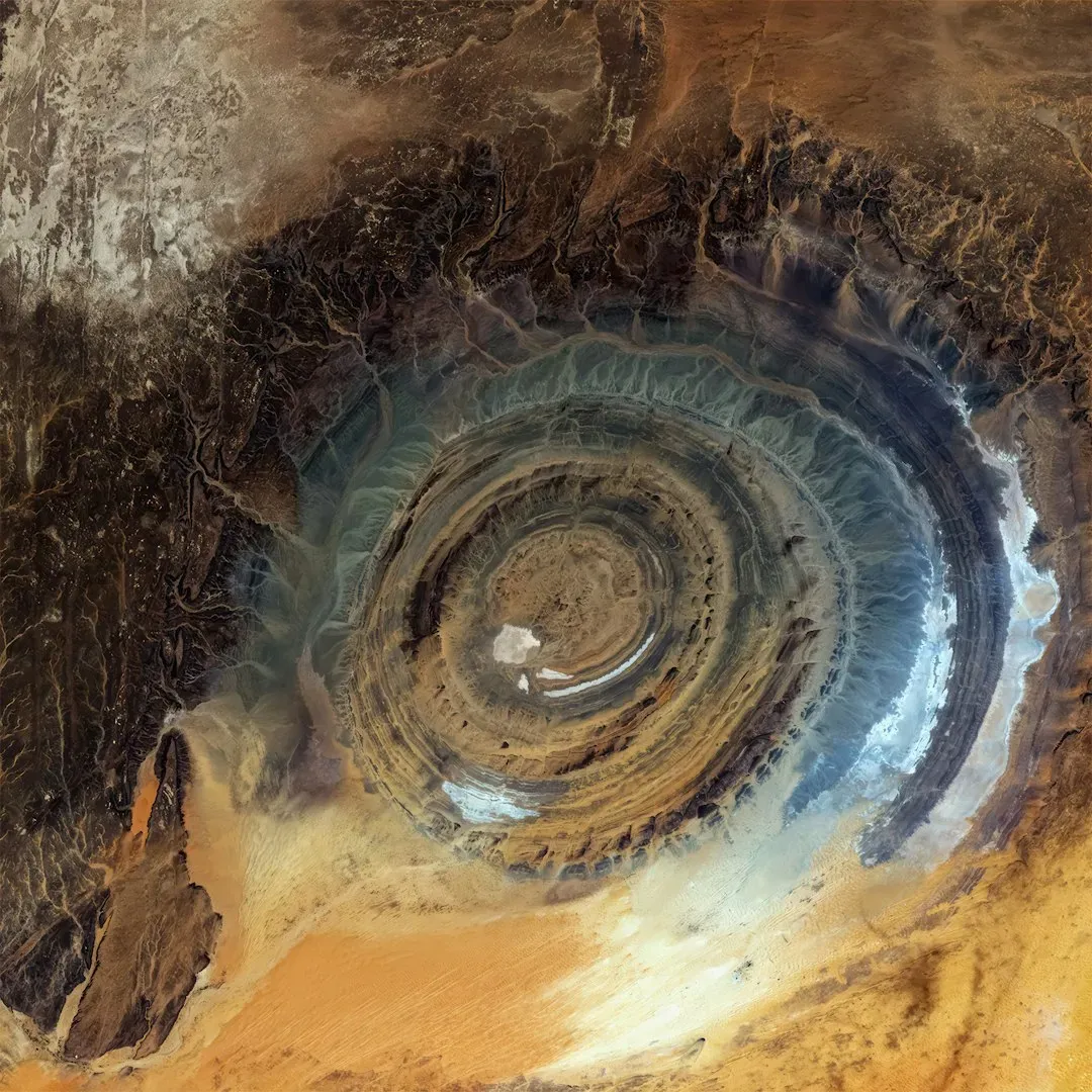
Known as the Richat Structure or the Eye of the Sahara, this massive geological formation resembles a giant eye and measures 25 miles in diameter, making it highly visible even from high above Earth. Although local people had known about the formation for centuries, the Eye of the Sahara gained international attention only in the 1960s, during the era of early space missions when astronauts aboard NASA’s Gemini 4 mission spotted the structure.
It is an eroded geological dome, 40 kilometres in diameter, caused by a subsurface igneous intrusion deforming the overlying sedimentary rock layers, causing the rock to be exposed as concentric rings with the oldest layers exposed at the centre of the structure. At first, scientists believed it was a meteorite impact crater, but later studies proved otherwise as no traces of shocked quartz, melted rock, or impact debris were ever found. Standing at the center feels almost surreal, as if you’re inside a target painted by the planet itself. The Eye sits on the Adrar Plateau in central Mauritania and the area is arid, wind-sculpted, and eerily silent.
Giant’s Causeway: Northern Ireland’s Hexagonal Masterpiece
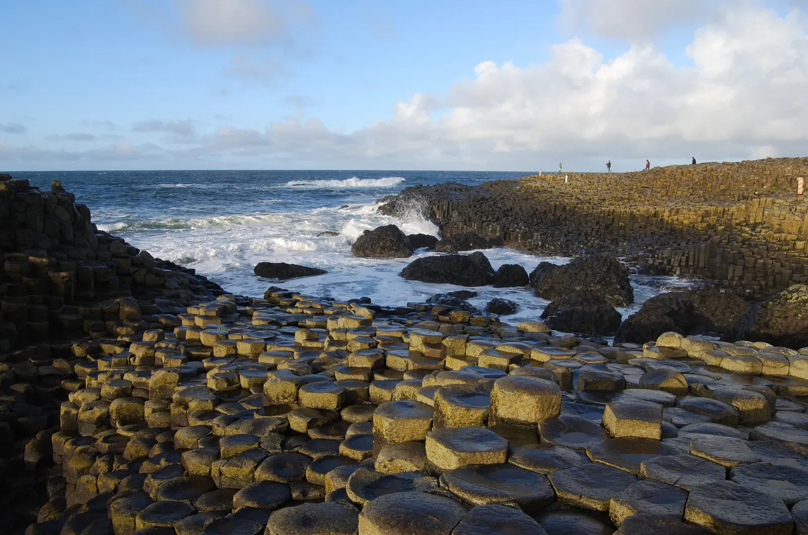
The Giant’s Causeway is an area of approximately 40,000 interlocking basalt columns, the result of an ancient volcanic fissure eruption. What makes this site unique isn’t just the columnar basalt itself, but the sheer perfection and accessibility of these formations along the dramatic Irish coastline. Around 50 to 60 million years ago, during the Paleocene Epoch, Antrim was subject to intense volcanic activity when highly fluid molten basalt intruded through chalk beds. As the lava cooled, contraction occurred and horizontal contraction fractured in a similar way to drying mud.
The columns vary in height and diameter, with some reaching up to 12 meters tall, and in some areas, the columns are stacked on top of one another, while in others, they form natural bridges and arches. The legend surrounding this wonder adds another layer of intrigue. According to one popular legend, the Irish giant Finn MacCool created the causeway as a pathway to Scotland to fight his Scottish rival, Benandonner, but when Finn saw the size of Benandonner, he became afraid and fled back to Ireland.
The Wave: Arizona’s Frozen Ocean
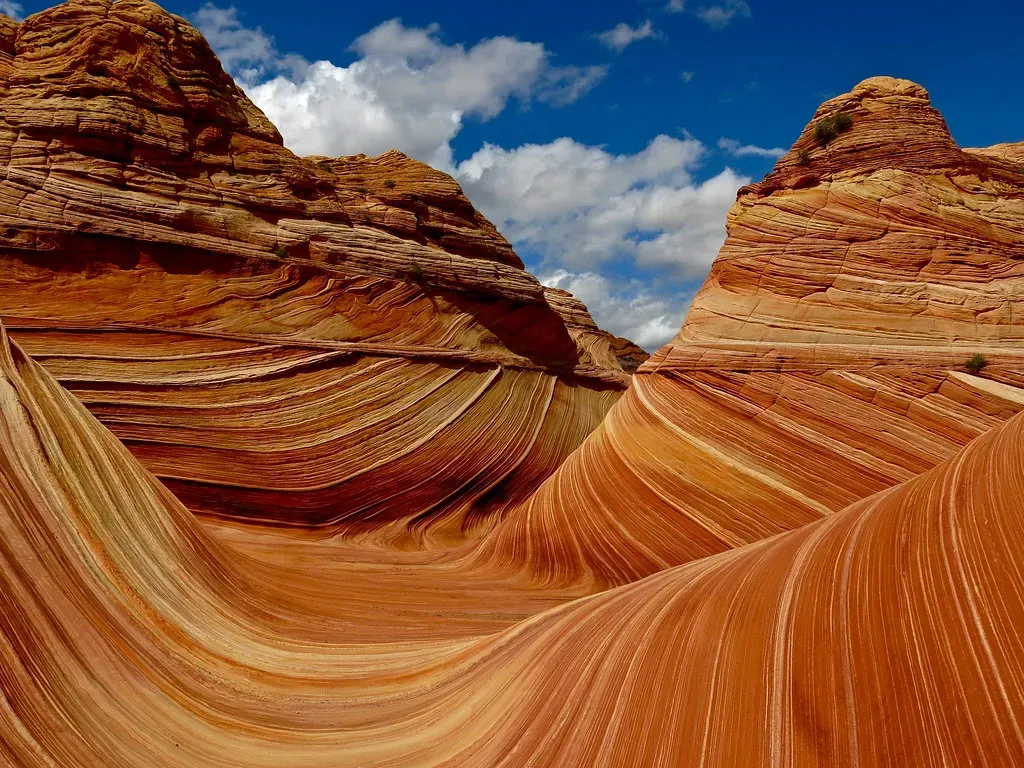
The Wave consists of intersecting U-shaped troughs that have been eroded into Navajo Sandstone of Jurassic age, with the two major troughs which comprise this rock formation being 62 feet wide by 118 feet long and 7 feet wide by 52 feet long. Known for its sandstone streaks in shades of red, orange, and pink, it resembles undulating waves frozen in time and was formed around 190 million years ago during the Jurassic period.
Initially, infrequent runoff eroded these troughs along joints within the Navajo Sandstone, but after their formation, the drainage basin shrank to the point that the runoff became insufficient and the troughs are now almost exclusively eroded by wind. Here’s the kicker: accessing this wonder requires winning a permit lottery. The Bureau of Land Management limits access to just 64 permits per day, and the popularity of The Wave is such that the chances of obtaining a permit by either advance lottery or the day-before lottery are much less than 50% from March through November. Honestly, this scarcity only adds to the mystique.
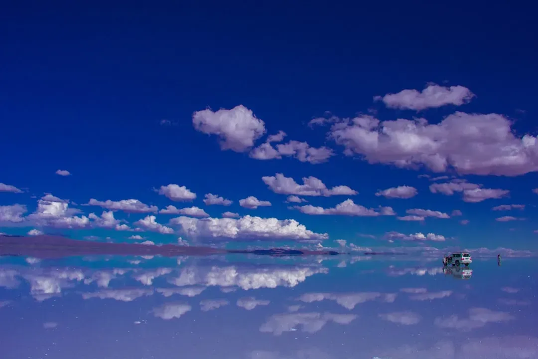
Salar de Uyuni: Bolivia’s Sky Mirror
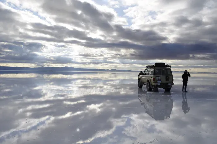
The Salar was formed as a result of transformations between seven prehistoric lakes that existed around 40,000 years ago but all evaporated over time, and it is now covered by an 8 meter thick layer of salt, which is extremely flat. The Salar de Uyuni is the world’s largest salt flat and the bright-white landscape stretches for more than 4,000 square miles, so vast that it can be seen from space.
What truly sets this place apart from all other salt flats? Following rain, a thin layer of dead calm water transforms the flat into the world’s largest mirror, 129 km across. The reflection becomes so perfect that you genuinely cannot tell where the ground ends and the sky begins. Located in the Lithium Triangle, the Salar contains a large amount of sodium, potassium, lithium and magnesium, and as of 2024, Bolivia holds about 22% of the world’s known lithium resources with most of those in the Salar de Uyuni.
Cave of Crystals: Mexico’s Subterranean Cathedral
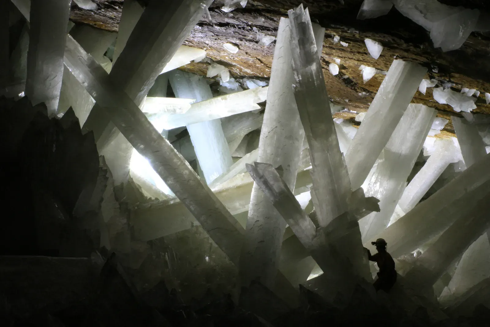
The otherworldly crystals in the Cave of the Crystals in Mexico can reach sizes larger than houses, by far the largest such crystals known on the planet, and they apparently grow at incredibly slow rates, gypsum formations that take as long as a million years to reach more than two stories tall. Located beneath the Chihuahuan Desert, this chamber remained hidden until miners accidentally discovered it in the year 2000.
The cave maintained a consistent temperature of 58°C and 90-100% humidity for 500,000 years, allowing the crystals to grow to massive sizes, and the conditions are so extreme that visitors must wear specialized cooling suits and can only stay for short periods. Think about that. Half a million years of perfect, undisturbed conditions created these giants. Researchers speculate that microscopic pockets of liquid within these giant crystals might hold microbes. The cave is basically a time capsule with potentially ancient life preserved inside translucent pillars.
Tsingy de Bemaraha: Madagascar’s Stone Forest
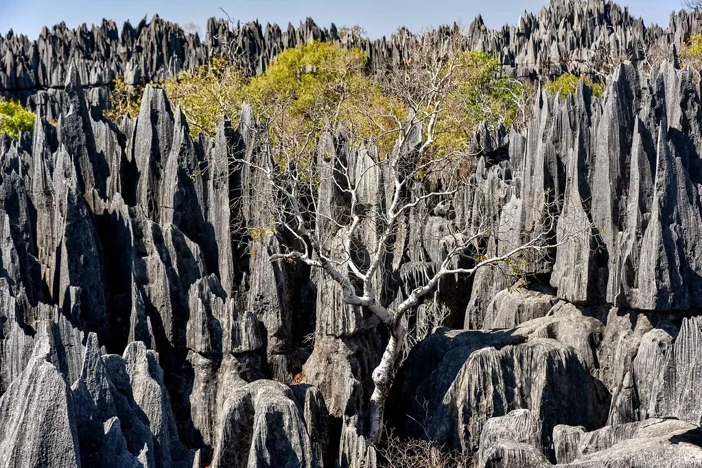
Tsingy de Bemaraha National Park in Madagascar is characterized by its sharp limestone formations known as tsingy, with the word tsingy translating to where one cannot walk barefoot in the local Malagasy language, and the park is a UNESCO World Heritage Site spanning an area of around 1,575 square kilometers. Tsingy was named due to unique, sharp-edged limestone formations erected over the entire park, and Tsingy de Bemaraha appeared after centuries of acidic rain, which created layers of sedimentation, providing a jagged backdrop and a hotspot for biodiversity.
The tsingy formations in the park are the result of millions of years of geological processes as over time, the limestone plateau was shaped by erosion, with rainwater carving deep fissures, gorges, and razor-sharp pinnacles that reach heights of up to 50 meters. Traversing this landscape requires ropes, harnesses, and courage. The stone needles slice through the sky like nature’s own fortress. It’s hard to believe this jagged wonderland exists anywhere on Earth, let alone just on one island.
Moeraki Boulders: New Zealand’s Mysterious Spheres
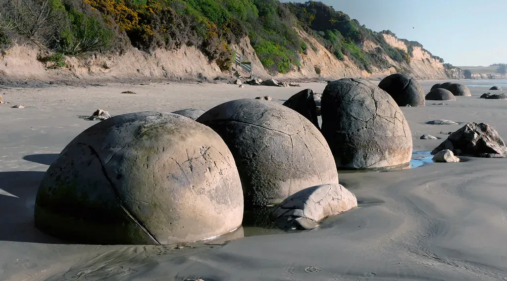
The Moeraki Boulders are large, spherical stones scattered along Koekohe Beach on New Zealand’s Otago coast, and these boulders, some up to three meters in diameter, are concretions formed approximately 60 million years ago with their near-perfect spherical shapes and large sizes making them a geological curiosity. Unlike regular rocks shaped by erosion, these spheres formed from the inside out through a process of accretion.
Mineral crystals accumulated around a core, gradually building outward in layers. The result? Perfectly round boulders that look like they were sculpted by ancient giants or dropped from space. Some have cracked open, revealing crystalline interiors that only deepen the mystery. Walking among them feels like stepping onto an alien beach where the laws of geology bent just enough to create something utterly bizarre.
Stone Forest: China’s Limestone Labyrinth
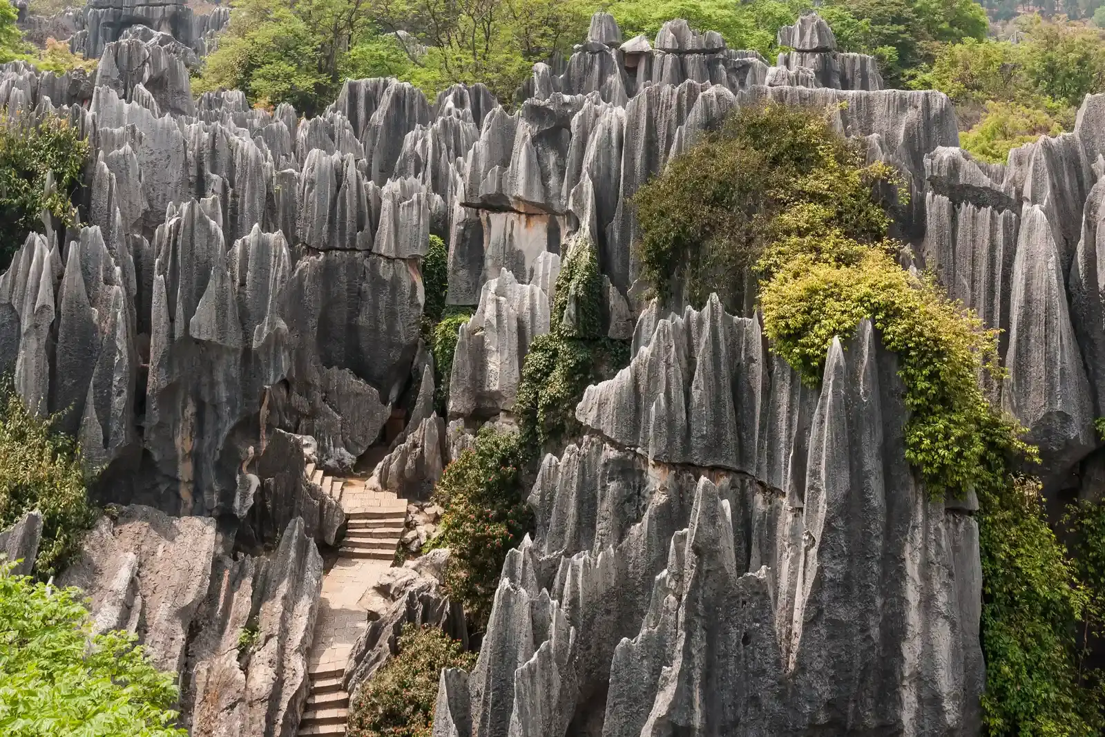
Stone Forest, located in Kunming, China, is a rock formation that looks exactly as it is described with tall limestone formations creeping up into the sky from the ground like petrified trees, and the stone forest dates back around 270 million years and covers about 186 miles altogether. The limestones are about Permian Age, around 270 million years old, and once formed underwater in a shallow sea, with parts of the forest being UNESCO World Heritage Sites and known about since the Ming Dynasty.
The formations don’t just rise vertically. They twist, lean, and interlock like nature’s own hedge maze carved from solid rock. One of the stones in particular, the Ashima Stone, has a legend attached to it: it is said that the rock was formed after a woman, Ashima, ran into the forest after being told that she was unable to be with the man she loved. Local legends add romance to the geological spectacle, but what truly astonishes is the scale and density of these stone pillars concentrated in one region.
Chocolate Hills: Philippines’ Sweet Geology
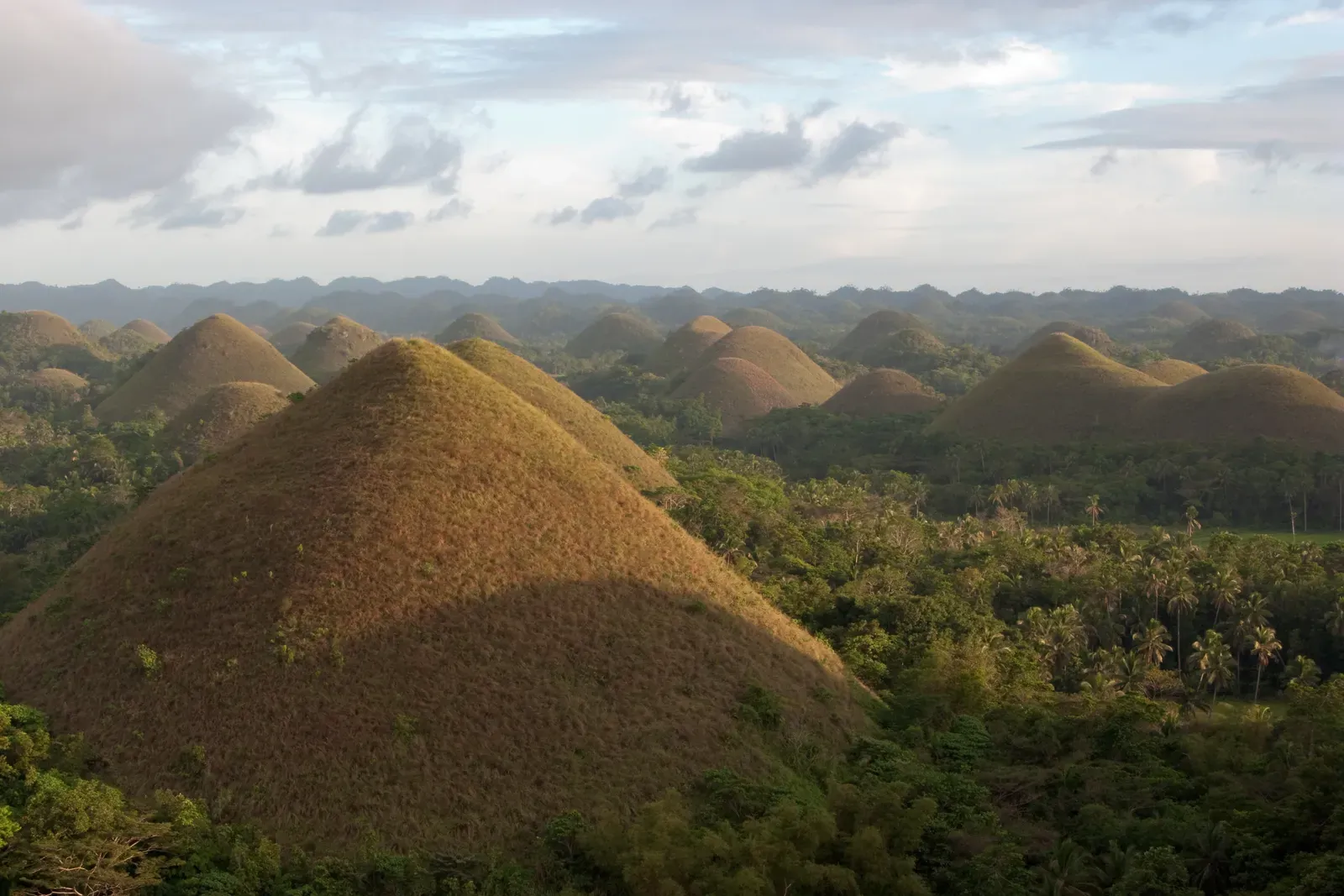
The Chocolate Hills are a group of at least 1,260 hills spread over an area of more than 50 square kilometers in Bohol, Philippines, and during the dry season, the grass covering the hills turns brown, resembling chocolate drops, hence the name, with these limestone hills formed by the uplift of coral deposits and the action of rainwater and erosion over millions of years.
The hills are almost uniform in shape and size, creating a surreal landscape, and they are one of the Philippines’ top tourist attractions, offering a unique and picturesque view. What strikes you first is the uniformity. Over a thousand hills, all roughly the same conical shape, all lined up like nature decided to practice symmetry. No other place on Earth has replicated this bizarre combination of coral geology and tropical weathering to produce such a regular pattern.
Darvaza Gas Crater: Turkmenistan’s Door to Hell
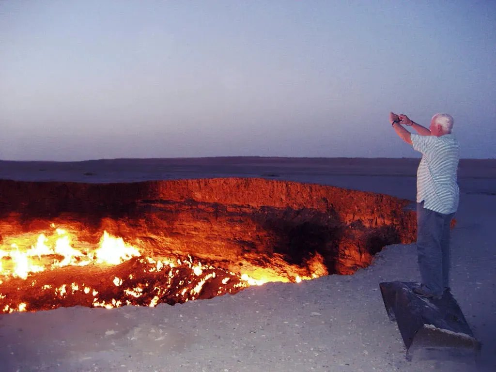
The Door to Hell is a natural gas field in Derweze, Turkmenistan, that collapsed into an underground cavern in 1971, becoming a natural gas crater, and geologists set it on fire to prevent the spread of methane gas, and it has been burning continuously since then, with the diameter of the crater being 69 metres and its depth being 30 metres. Let’s be real, this one’s partly human-made, but the ongoing phenomenon is entirely unique.
What makes this one unique is how it was formed; soviet explorers accidentally drilled into the cavern, causing it to collapse. Located in the Karakum Desert, the Darvaza Gas Crater burns so brightly it can be seen for miles at night, and the surrounding ground is hot enough to melt plastic and the air shimmers with waves of heat. Standing at the rim at night, watching flames dance across the crater floor, you experience something primal. It’s been burning for over fifty years with no signs of stopping. How’s that for commitment?
Conclusion: Earth’s Singular Masterpieces
These ten formations remind us that Earth is still full of surprises. While most geological features have counterparts elsewhere, these sites stand alone. They’re the result of perfect storms of timing, chemistry, tectonics, and erosion that haven’t been replicated anywhere else on the planet.
Visiting any of these places means witnessing something genuinely irreplaceable. They’re not just Instagram backdrops or bucket list checkboxes. They’re proof that our planet still knows how to surprise us, even after billions of years of practice. Whether it’s hexagonal columns rising from the Irish coast or perfectly spherical boulders on a New Zealand beach, each formation tells a story that can’t be told anywhere else.
So which one would you visit first? Have you already been to any of these rare wonders? The beauty of geological singularities is that once you see one, you’ve experienced something nobody else can replicate.