
Building Anticipation for a Major Winter Blast (Image Credits: Pixabay)
New York City – Residents across the five boroughs opened their eyes Saturday morning to a layer of fresh snow that coated sidewalks and streets, though the accumulation proved milder than meteorologists had predicted.
Building Anticipation for a Major Winter Blast
The winter storm approached the Tri-State Area with considerable fanfare, prompting officials to issue widespread warnings and even declare states of emergency in New York and New Jersey. Forecasters had projected up to 8 inches or more in parts of the region, marking the most substantial snowfall in nearly four years for Central Park. Snow began falling late Friday evening around 6 p.m., intensifying overnight as cold air locked in place across the Northeast. The system brought a mix of snow and sleet to some areas, but temperatures remained below freezing, ensuring an all-snow event for much of the metro area. Travel advisories urged caution, with expectations of slick roads and potential delays at major airports like JFK and LaGuardia.
By midnight, the precipitation had picked up pace, creating a wintry scene that recalled the region’s harsher winters of the past. Yet, as the storm evolved, subtle shifts in its track led to reduced intensities compared to initial models. This adjustment spared the city from the heavier totals seen farther north and east, where interior Connecticut and the Lower Hudson Valley fared worse.
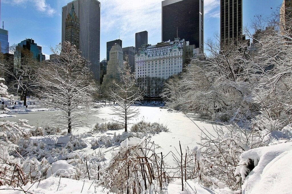
Snowfall Realities: A Modest Coating Emerges
Come dawn on Saturday, the snow had tapered off, leaving behind accumulations that fell short of the hype. Official measurements clocked in at 4.3 inches in the Bronx’s Fordham neighborhood, while LaGuardia and JFK airports each reported 4.1 inches. Central Park, often a benchmark for the city, saw totals around 4 inches, the highest since January 2022. New Jersey experienced similar restraint, with Harrison at 4 inches, Springfield at 3 inches, and Newark at 2.5 inches. These figures represented a welcome deviation from the 6-to-8-inch forecasts that had dominated headlines.
The lighter snowfall stemmed from the storm’s southern tilt, which introduced more sleet and reduced snow growth in the urban core. Still, the event qualified as the season’s first notable snow for the area, dusting parks and delaying early holiday cleanup efforts. Crews deployed salt trucks promptly, but icy patches lingered in shaded spots.
Disruptions Tempered by Reduced Intensity
Though the snow arrived with less force, it still complicated the morning commute for many New Yorkers shaking off post-Christmas routines. Highways like the New Jersey Turnpike saw slowdowns, and subway delays cropped up due to signal issues in the chill. Schools remained closed in several districts, giving families an extra day of holiday respite. Air travel faced minor hiccups, with a handful of flights grounded overnight, but major carriers reported quick recoveries by midday.
Urban life adapted swiftly; plows cleared major arteries by late morning, and residents bundled up for errands. The storm’s wind-whipped flurries added a dramatic flair, but without the crippling totals, power outages stayed limited to isolated spots in outer boroughs. Emergency services handled a uptick in minor accidents, emphasizing the need for winter tires even in lighter events.
Regional Variations and Broader Impacts
Beyond the city limits, the storm painted a patchwork of weather across the Northeast. Southern Connecticut and southeast New York accumulated closer to 6 inches in some pockets, prompting ongoing warnings for slick roads. Pennsylvania dealt with freezing rain farther southwest, creating hazardous overpasses and bridges. The National Weather Service adjusted alerts as the system weakened, lifting most winter storm warnings by early afternoon.
This event highlighted the region’s vulnerability after mild winters, reminding residents of snow’s potential to snarl logistics. Businesses in tourism-heavy areas like Times Square saw fewer crowds, while delivery services pivoted to four-wheel drives. Overall, the subdued outcome allowed the Tri-State to rebound faster than feared.
- Central Park: 4 inches – Biggest snowfall since 2022
- Bronx (Fordham): 4.3 inches
- LaGuardia Airport: 4.1 inches
- Newark: 2.5 inches
- Harrison, NJ: 4 inches
Key Takeaways
- The storm delivered the first significant snow of the season, but totals stayed below 5 inches in NYC.
- Temperatures hovered near freezing, prolonging road hazards into Saturday afternoon.
- Officials praised proactive preparations that minimized widespread disruptions.
As the sun broke through clouds later in the day, New York City shook off the snow’s grip, underscoring the unpredictable nature of winter weather in a bustling metropolis. With clearer skies ahead, the focus shifts to holiday wrap-ups and New Year’s preparations – what are your plans to navigate the rest of the season’s surprises? Share in the comments below.