Across what is now the United States, Indigenous engineers reshaped rivers, mountains, forests, and coastlines long before steel, concrete, or satellites ever existed. Yet for generations, their achievements were sidelined or dismissed as “primitive,” even as archaeologists quietly kept uncovering evidence of complex design, advanced math, and deep ecological intelligence. Today, new research using lidar, remote sensing, and soil science is revealing just how wrong that old story was. From desert irrigation that still works to city-scale earthen architecture aligned with the sun and stars, the engineering of Native nations is forcing scientists to rewrite the technical history of North America. The question is no longer whether these were advanced systems – but how much of our modern engineering quietly leans on knowledge they figured out first.
Earthworks That Redefined the Landscape
One of the most visually stunning engineering feats in North America is also one of the least understood by the general public: the monumental earthworks of the Eastern Woodlands. At places like Poverty Point in present-day Louisiana and the Newark Earthworks and Serpent Mound in Ohio, Indigenous builders moved millions of baskets of soil to sculpt vast geometric and symbolic forms. These are not random mounds; they are precisely shaped complexes involving circles, octagons, embankments, and avenues that stretch across wide areas. Archaeologists have found that some align with solar and lunar positions, suggesting careful observations over many generations. When you stand at the center of one of these complexes, the scale feels more like an airport or stadium than a “mound.”
What makes these earthworks so remarkable from an engineering perspective is that they were constructed without draft animals, metal tools, or wheeled vehicles. Soil had to be sourced, transported, and compacted in ways that would hold up for centuries, often in flood-prone river valleys. Engineers today recognize that this required sophisticated knowledge of local soils, water flow, and stability – essentially geotechnical engineering done by experience and experiment rather than textbooks. Modern surveying techniques have confirmed that many embankments are remarkably uniform in height and thickness across long distances. It is a reminder that large-scale infrastructure does not always require concrete; sometimes it just requires a very patient, very organized society with a clear vision of what the land should look like.
Cahokia: A Metropolis Built in Earth and Sky
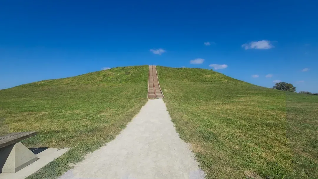
On the Mississippi floodplain near present-day St. Louis, the city of Cahokia rose a thousand years ago as one of the largest urban centers in the precolonial Americas. At its peak, its population likely rivaled or exceeded many European cities of the same era, and its planners engineered more than one hundred earthen mounds, broad plazas, and a carefully ordered street grid. The massive central platform, known as Monks Mound, covers an area larger than many modern sports arenas and stands as high as a ten- to twelve-story building. Building it meant moving an astonishing volume of earth in carefully layered lifts, which helped prevent catastrophic collapse in the region’s soft, wet soils. The city also incorporated a timber “woodhenge” likely used for tracking solar events and structuring ceremonial calendars.
From an engineering lens, Cahokia showcases systems thinking: how to manage food, water, traffic, and ritual within a dense population center. Its location near river confluences positioned it as a trade and communication hub, while the surrounding landscape was transformed into fields, managed forests, and fish-rich wetlands. Recent excavations and soil analyses suggest that Cahokian engineers understood how to build on floodplains without losing everything to seasonal waters, using elevation, drainage channels, and strategic placement of key structures. The city eventually declined, but the methods its builders used to shape earth and space still intrigue urban planners and geomorphologists. In a time when modern cities are struggling with flooding, heat, and sprawl, Cahokia stands as a reminder that sustainable urban design has very deep roots in this land.
Desert Irrigation and the Science of Scarcity
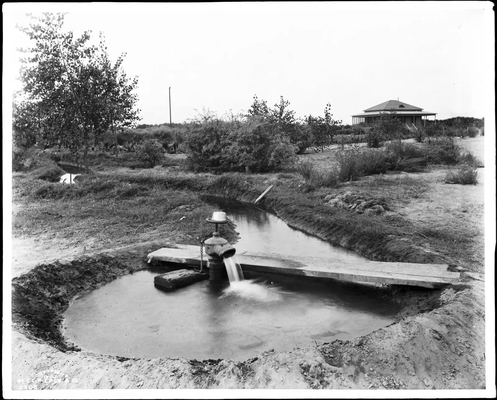
In the arid Southwest, Indigenous engineers developed water systems that still astonish hydrologists. The Hohokam, whose descendants include the O’odham peoples of present-day Arizona, carved hundreds of miles of irrigation canals through desert soils, diverting rivers like the Salt and Gila to support intensive agriculture. These canals often followed gentle, carefully calculated gradients that allowed water to flow without eroding the channel or stagnating. Some were large enough to rival small modern irrigation ditches, and they supported fields of corn, beans, squash, and cotton in a landscape that receives little rain. Mapping studies have revealed multiple phases of expansion, repair, and realignment over centuries, showing that this was a living infrastructure system, not a one-time project.
What is most impressive is how well some of these canal alignments still work. In more than one case, modern irrigation districts in the Phoenix basin have built or routed canals along the same paths first cut by Hohokam engineers. That continuity across nearly a millennium speaks to how carefully they read the land and how well they managed sediment, slope, and seasonal variation. Instead of brute-force concrete and pumps, they relied on gravity, observation, and adaptive maintenance. In an era when Western water rights are under intense pressure and megadrought conditions are redefining the Southwest, these ancient systems are becoming case studies in how to design for scarcity rather than abundance. They stand as quiet, flowing evidence that extreme environments often produce the most elegant engineering.
Terraced Fields, Forest Engineering, and Controlled Fire

Not all Indigenous engineering looks like a monument; sometimes it looks like a hillside or a forest that simply “works.” In the Pacific Northwest, California, and parts of the Southeast, Native nations practiced controlled burning and landscape management that functioned as a kind of ecological infrastructure. Regular, low-intensity fires reduced underbrush, encouraged desired plant species, and created open woodlands that were easier to travel through and hunt in. These were intentional, patterned burns with clear objectives, governed by cultural rules and seasonal knowledge. Modern fire scientists now recognize that the catastrophic wildfires of recent decades were partly fueled by the interruption of this Indigenous fire regime.
In other regions, like the Southwest and Appalachians, terracing and check dams turned steep or erosion-prone slopes into stable, productive farmland. By stacking stones, building small earth embankments, and guiding water into controlled channels, Indigenous farmers slowed runoff and captured precious moisture. Soil studies often show deep, stable profiles in these terraced areas, suggesting centuries of careful use rather than rapid exhaustion. You can think of these systems as green infrastructure centuries ahead of the term: engineering that works with plant roots, soil microbes, and natural topography instead of against them. As climate change brings more intense rainstorms and longer droughts, land managers are looking back at these methods for inspiration on how to keep hillsides from collapsing and forests from exploding into flame.
Cliff Dwellings and Passive Climate Control
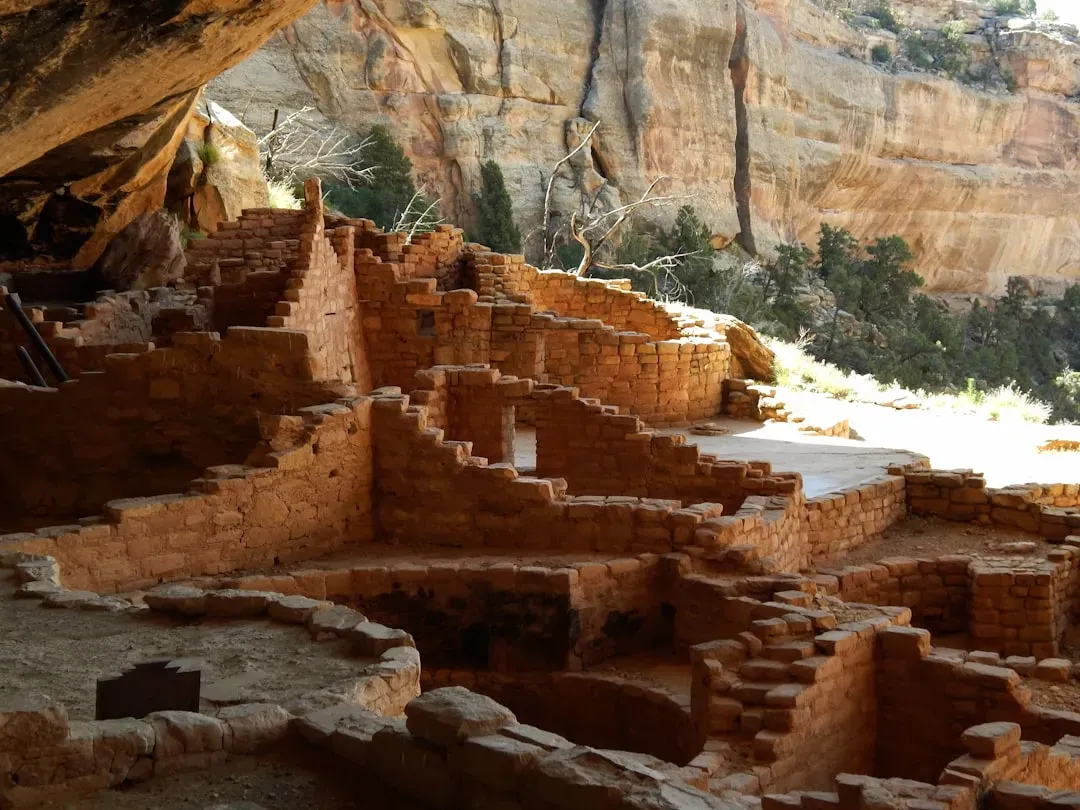
In the canyons of the Four Corners region – today overlapping Colorado, Utah, Arizona, and New Mexico – the cliff dwellings associated with Ancestral Puebloan peoples showcase architectural ingenuity tuned to extreme environments. Villages such as Mesa Verde and structures at places like Canyon de Chelly were built into alcoves in sandstone cliffs, using stone masonry, wooden beams, and plaster. Their placement was anything but random. By tucking homes into south-facing or shaded walls, builders took advantage of solar angles and rock mass to regulate temperature: warmer in winter, cooler in summer. In effect, they created passive heating and cooling systems long before the invention of HVAC units.
These dwellings also reveal sophisticated structural choices. Builders understood how to anchor beams into rock, distribute loads across stacked masonry, and use small openings to control light and ventilation. Multistory room blocks show evidence of careful planning, not ad hoc accretion, and the circular kivas demonstrate standard dimensions and forms repeated across sites. Archaeologists and architects alike have studied these cliff communities as models of compact, thermally efficient housing. In a world grappling with high energy use and a need for climate-resilient buildings, the lessons from these canyon walls feel surprisingly fresh. They suggest that one path forward in sustainable design may involve re-learning how to listen to shade, stone, and sun the way their original builders did.
Star Knowledge, Alignments, and Invisible Infrastructure
Engineering is not only about what you can see; sometimes, it is about how structures line up with the unseen motions of the sky. Across the continent, from Chaco Canyon in New Mexico to the great earthworks of Ohio, Indigenous builders embedded astronomical observations into their designs. At Chaco, certain great houses and windows align with solstice sunrises or lunar standstill events, implying generations of systematic sky-watching and data gathering. In the Eastern Woodlands, the geometry of some earthworks lines up with complex lunar cycles in ways that have only recently been confirmed by archaeologists and archaeoastronomers. These alignments are not accidents; they reflect a worldview in which timekeeping, ceremony, and engineering are all braided together.
This kind of “invisible infrastructure” is easy to overlook if you are trained only to see engineering as pipes and beams. Yet it required rigorous observational practice and the ability to translate abstract patterns into physical layout on the ground. In many cases, the scale is so large that alignments only become obvious from the air or through modern mapping software. That delayed recognition says more about our limited expectations than about the builders’ abilities. Today, scientists increasingly describe these sites as observatories and data archives encoded in stone and soil. They invite a broader definition of engineering – one that includes the design of systems to track celestial cycles and synchronize human activity with the wider cosmos.
Why These Engineering Feats Still Matter

It is tempting to treat all of this as a distant curiosity, a kind of historical museum of clever ideas from long ago. But doing that misses the central point: these are engineering traditions from nations that still exist, whose descendants are very much alive and often still practicing forms of this knowledge. The erasure of Indigenous engineering has shaped how Americans think about science and technology, quietly reinforcing the idea that innovation is something that arrived from elsewhere. When we restore the record, a different picture emerges, one in which North America has been a laboratory of hydrology, architecture, agriculture, and systems design for thousands of years. That recognition carries ethical weight, because it invites questions about land, credit, and who gets to be called an engineer.
There is also a strictly practical reason this history matters: many of the problems these systems solved are the same ones we face now, just under new names. Managing drought, building in floodplains, preventing catastrophic fires, designing for extreme heat, tracking environmental cycles – these are front-page issues in the twenty-first century. Indigenous engineers of the past approached them with constraints that look a lot like the ones we are beginning to confront: limited energy, no fossil fuels, a need to keep systems repairable with local materials. When policymakers and scientists invite Tribal nations into climate and infrastructure planning, they are not just being inclusive; they are tapping into deeply field-tested design traditions. The larger scientific importance lies in realizing that modern “innovation” often advances faster when it is willing to learn from the oldest experiments on the land.
The Future Landscape: Reviving, Partnering, and Scaling Up

Looking ahead, the most exciting developments are not about reconstructing ancient canals or rebuilding mounds exactly as they were. Instead, they involve partnerships where Indigenous communities lead the adaptation of their engineering traditions to today’s challenges. Tribal forestry programs are working with federal and state agencies to restore cultural burning practices, aiming to reduce wildfire risk while reviving ecosystems. In the Southwest, Tribal water managers are part of complex negotiations over river compacts, bringing perspectives shaped by long histories of drought and careful allocation. Engineers and climate scientists are beginning to treat these collaborations as living laboratories for hybrid solutions that merge modern tools with place-based knowledge.
Technologies like lidar, satellite imaging, and 3D modeling are also reshaping how these feats are documented and understood. Entire city-sized earthwork complexes that were once hidden by forests are being mapped in high resolution, revealing planning principles that can be plugged into computer simulations and design software. At the same time, there is a growing movement to ensure that data about sacred sites is controlled by the Indigenous nations to whom they belong. The global implications are substantial: communities from the Amazon to Australia are watching how the United States does – or does not – center Indigenous engineering in its climate response. If we treat these systems merely as artifacts, we risk losing some of the most durable blueprints for living within planetary limits. If we treat them as active, evolving knowledge, they may help guide infrastructure planning far beyond this continent.
How Readers Can Engage With This Legacy
For most people, connecting with these engineering feats starts with something deceptively simple: paying attention to the land and who shaped it. Visiting places like Mesa Verde, Chaco Culture, or the earthwork sites of the Midwest with this engineering lens can transform the experience from sightseeing into a kind of field study. Many Tribal nations and museums now offer interpretation that foregrounds Indigenous science and engineering rather than treating it as an afterthought. Supporting those programs – by choosing guided tours, attending public talks, or backing Tribal cultural centers – helps shift which stories get told and funded. Even something as basic as reading the history of the land you live on and learning the names of the nations tied to it can change how you see local rivers, hills, and forests.
There are also ways to connect this history to present-day choices. When wildfire, drought, or flood stories hit the news, look for whether Indigenous experts are at the table and seek out their perspectives when they are not. If you work in engineering, planning, or environmental science, consider how concepts like controlled burning, terracing, or gravity-fed irrigation might inform your own projects – not as templates to copy, but as proof that low-energy, long-lasting solutions are possible. On a personal level, supporting Indigenous-led conservation organizations, land back efforts, and educational initiatives can help ensure that the people who carry this knowledge have the resources and authority to keep using it. The next time you cross an irrigated field, walk through an open woodland, or trace a city’s edges along an old river, it is worth asking whose designs you are walking through, even if the blueprints were drawn a thousand years ago.

Suhail Ahmed is a passionate digital professional and nature enthusiast with over 8 years of experience in content strategy, SEO, web development, and digital operations. Alongside his freelance journey, Suhail actively contributes to nature and wildlife platforms like Discover Wildlife, where he channels his curiosity for the planet into engaging, educational storytelling.
With a strong background in managing digital ecosystems — from ecommerce stores and WordPress websites to social media and automation — Suhail merges technical precision with creative insight. His content reflects a rare balance: SEO-friendly yet deeply human, data-informed yet emotionally resonant.
Driven by a love for discovery and storytelling, Suhail believes in using digital platforms to amplify causes that matter — especially those protecting Earth’s biodiversity and inspiring sustainable living. Whether he’s managing online projects or crafting wildlife content, his goal remains the same: to inform, inspire, and leave a positive digital footprint.