Across Earth’s surface, there are places that feel like they were designed to annoy geologists. The rocks are real, the measurements are solid, the dating is careful – and yet the stories those formations tell do not quite line up with the scripts in our textbooks. In the past few decades, better satellites, sharper dating techniques, and more patient fieldwork have explained many former “mysteries,” but a stubborn handful still sit in the gray zone between hypothesis and head-scratcher. These are the formations that keep scientists arguing in conference hallways and pulling old core samples out of storage. And they remind us that, for all we claim to understand Earth, there are still corners where the planet seems to grin and say: not so fast.
The Yonaguni Monument: Natural Terrace or Sunken Architecture?
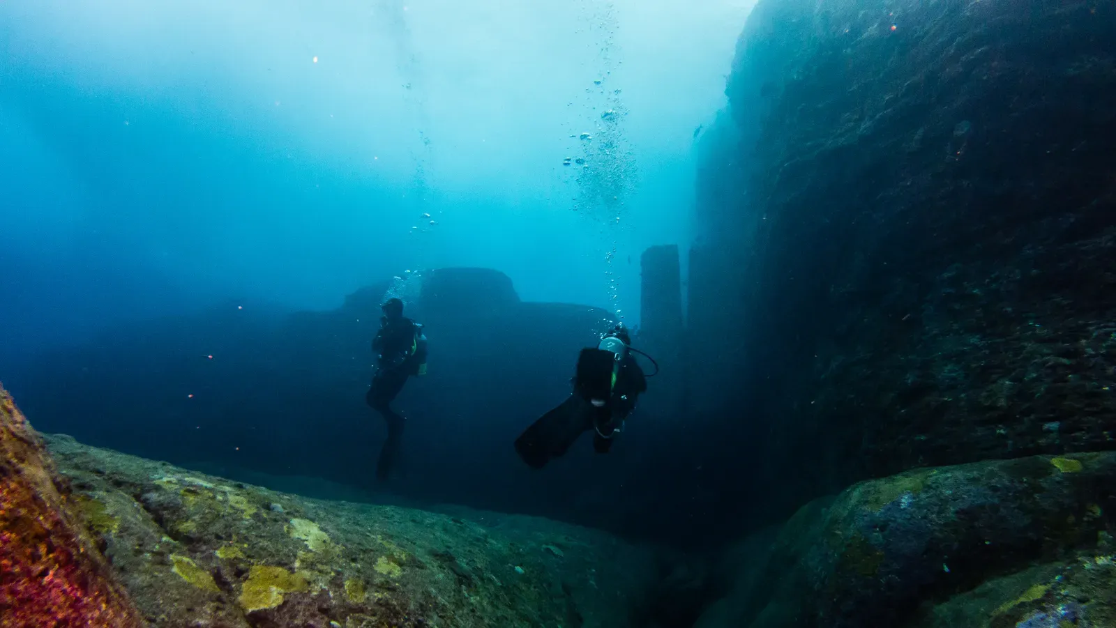
If there is one site that perfectly captures the battle between geology and imagination, it is the Yonaguni structure off Japan’s Ryukyu Islands. At a depth of about 5 to 25 meters below the surface, divers encounter massive, step-like platforms, towering walls, and sharply angled terraces that look uncannily like a sunken ceremonial complex. From some angles, the formation resembles ziggurats or stadium seating, with clean edges and straight corridors that seem too precise to be random. Local diving operators leaned into the myth early, marketing Yonaguni as an underwater “lost city,” which only intensified public fascination and scientific scrutiny. Standing on one of those stone ledges, with fish drifting through what looks like a hallway, it’s surprisingly hard to convince your own brain that this is just rock doing what rock does.
Most geologists argue that Yonaguni is a product of natural sandstone fracturing, combined with wave erosion and tectonic uplift in a region known for earthquakes. Sandstone beds tend to fracture along horizontal and vertical planes, which can produce right-angled steps that, from a distance, mimic blocks cut by human hands. Yet a minority of researchers point to odd features – isolated pillars, apparent “carvings,” and seemingly aligned platforms – that they argue are difficult to explain purely by natural processes. This tension creates a delicate scientific balancing act: how do you respect the power of well-understood mechanics like jointing and erosion, while still admitting you do not have every detail nailed down? For now, Yonaguni remains a geological Rorschach test, revealing at least as much about human pattern-seeking as about the seafloor itself.
The Devil’s Tower Puzzle: A Monolith with No Clear Blueprint
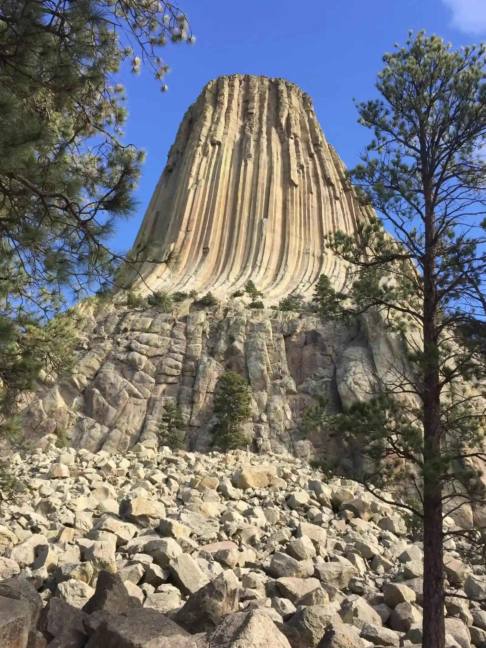
Rising more than 260 meters above the plains of northeastern Wyoming, Devils Tower looks like someone planted a colossal, fluted column in the middle of rolling ranch land and walked away. Its vertical hexagonal columns are so clean and continuous that early visitors struggled to believe they were natural; even now, the formation is a favorite visual shorthand for “alien” landscapes in popular culture. Scientifically, it is accepted as an igneous intrusion – magma that solidified underground and was later exposed as the softer surrounding rock eroded. The puzzle is not whether it is volcanic; the puzzle is exactly what kind of volcanic structure it once was. The neat textbook categories for igneous bodies – like laccolith, volcanic plug, or stock – do not fit Devils Tower comfortably, and that mismatch bothers geologists more than the public might suspect.
One big question is how the columns formed into such towering, nearly vertical prisms without slumping or breaking more chaotically over time. Typically, columnar jointing develops as lava or magma cools and contracts, producing polygonal columns that can be impressive but often shorter or more irregular. At Devils Tower, the columns are unusually tall and remarkably well preserved, as if protected by an invisible scaffold for millions of years. Various models suggest different original shapes – a shallow intrusion that later lost its “roof,” a feeder pipe for an ancient volcano, or even a rare type of subvolcanic dome – but each scenario clashes with some field evidence. As new geophysical surveys probe deeper into the rock beneath the tower, scientists hope to finally pin down its origin story; until then, this stark monolith remains a geological question mark protruding straight out of the American West.
The Eye of the Sahara: A Perfect Circle with an Imperfect Explanation
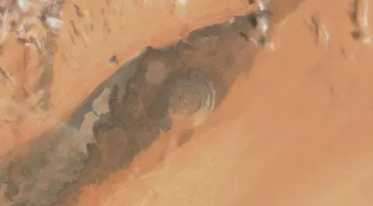
Seen from the ground, the Richat Structure in Mauritania is a series of low, eroded ridges and valleys. Seen from space, it becomes something else entirely: a near-perfect, multi-ringed circle spanning roughly 40 kilometers across the Sahara, like a gigantic fossilized target etched into the desert. Early astronauts nicknamed it “the Eye of the Sahara,” and even now it’s one of the most striking features on satellite imagery of northern Africa. Its symmetry once led many scientists to suspect an impact crater, the scar of a massive asteroid that slammed into Earth and then eroded over time. But detailed fieldwork turned up no definitive impact markers – no shocked quartz, no unmistakable melt sheet – which pushed researchers toward a more complex, and less satisfying, explanation.
The current leading idea is that the Richat is a deeply eroded, domed structure where concentric layers of rock of different ages have been sculpted into rings by wind and water. In this view, the eye-like pattern is an emergent property of uplift, fracturing, and erosion operating over hundreds of millions of years, rather than a single catastrophic event. Yet a few aspects still nag: the near-circular outline, the way certain ring segments appear surprisingly intact, and the difficulty recreating such a clean geometry in models. This is one of those cases where the general story – uplift plus erosion – is widely accepted, but the details refuse to snap into place neatly. The Eye of the Sahara sits at the intersection of understandable processes and unnerving visual precision, inviting fresh debates every time a sharper satellite image circulates online.
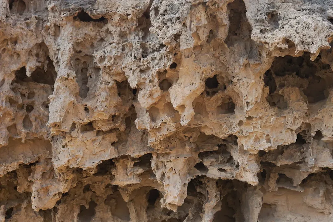
The Fairy Chimneys of Cappadocia: Sculpted by Time or Something Stranger?
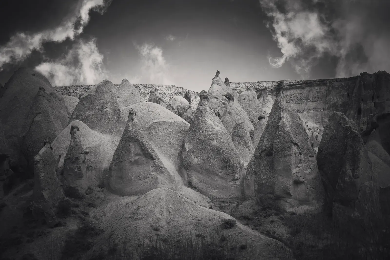
The volcanic badlands of Cappadocia in central Türkiye look like they were dreamed up for a fantasy film: slender stone towers capped with harder rock, soft cliffs riddled with caves, and entire villages once carved into spires and canyon walls. These “fairy chimneys” are usually explained as the product of differential erosion. A thick layer of ancient volcanic ash – welded into a soft rock called tuff – was buried beneath tougher basalt and other lava flows, then slowly sculpted by wind and rain. Where a chunk of harder caprock remained, the softer rock beneath eroded into a slender column; where the cap broke away, the tower eventually collapsed. On paper, the process is straightforward. On the ground, the result looks anything but ordinary.
What unsettles some observers is not just the shape of individual chimneys, but the way entire valleys seem packed with near-regular clusters of them, as if some organizing rule was at work. In several areas, chimneys line up along ridges or fault lines, hinting at deeper structural controls that are not fully modeled yet. Add in millennia of human modification – carved churches, homes, and dovecotes – and it becomes harder to disentangle pure geology from human influence. A few fringe voices try to insert unexplained mechanisms or lost technologies into the narrative, but the real story is more interesting: a complex interplay of rock strength, fractures, microclimates, and cultural history that still resists complete quantification. Even in a landscape where scientists broadly understand the ingredients, the precise recipe for Cappadocia’s surreal geometry remains an open problem.
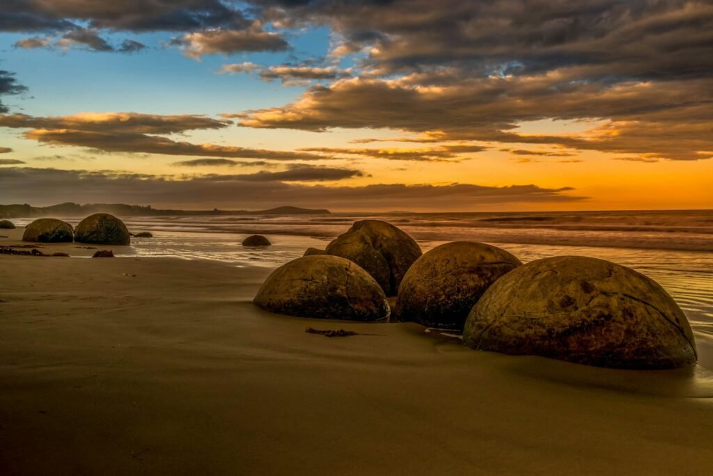
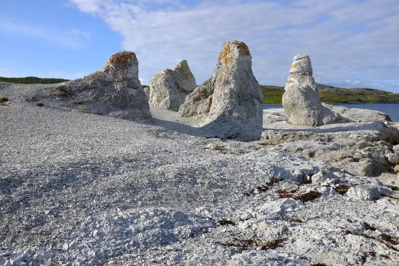
The Moeraki Boulders: Perfect Spheres Rolling Out of the Cliffs
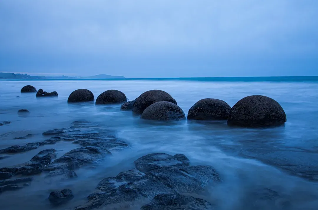
On Koekohe Beach on New Zealand’s South Island, dozens of nearly spherical boulders lie scattered across the sand like abandoned cannonballs. Some are as small as a bowling ball, while others are more than two meters across, with smooth surfaces that crack into polygonal patterns as they weather. These are the Moeraki Boulders, and the official explanation is that they are septarian concretions – masses of mineral cement that formed slowly within ancient marine sediments. Over millions of years, softer surrounding rock eroded away, leaving the hardened spheres exposed and eventually freed to roll down to the beach. The chemistry behind concretion is reasonably well understood, and similar features do exist elsewhere. Yet the Moeraki Boulders still occupy a strange space between “explained” and “deeply odd.”
What stands out is the sheer regularity and size distribution of these spheres, which are more precise and more massive than typical concretions in other regions. Many form nearly perfect globes, which would be difficult to machine at this scale, let alone grow in mud. The internal structure – radiating mineral veins and hollow centers in some cases – suggests highly ordered growth under conditions that are not easy to replicate in the lab. Scientists can outline the basics: mineral-rich fluids percolating through sediment, nucleation around organic material or shells, slow accretion of calcite over vast timescales. But they still struggle to answer the intuitive question a casual visitor might ask: why here, and why this perfectly? In that gap between mechanism and intuition, mythical explanations and local stories continue to flourish alongside peer-reviewed papers.
The Sailing Stones of Racetrack Playa: A Mystery Mostly Solved, but Not Quite
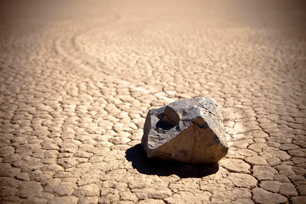
In Death Valley’s Racetrack Playa, rocks weighing tens of kilograms appear to have dragged themselves across the desert floor, leaving long, parallel furrows in the dried mud. For decades, no one had seen them move, and the playa is vast and remote enough that staging a hoax would be wildly impractical. Theories ranged from strong winds to magnetic fields to slippery algae films, each trying to reconcile the obvious tracks with the invisible motion. Then, in the past decade, time-lapse cameras and GPS-tagged stones finally caught them in the act under rare winter conditions. Thin sheets of ice formed around the stones overnight, and when morning sun and light winds combined, the ice rafts nudged the rocks along at a slow crawl, carving graceful pathways in the softened mud beneath.
This elegant solution answered most of the long-standing questions, but, as usual, it raised new ones. Not every track fits the simple ice-raft model; a few older, deeper furrows seem to demand stronger forces than those observed during modern events. Climate change is also altering the frequency and thickness of seasonal ice on the playa, which may already be shifting the behavior of the system. In other words, we solved the mystery just as the conditions that allowed it were starting to change. The Racetrack stones now serve as a case study in how rare environmental coincidences can produce seemingly impossible geological behavior – and how quickly those coincidences can disappear. Even a “mostly solved” puzzle can still defy clean, timeless logic.
Why These Geological Oddities Matter
It can be tempting to file these formations under harmless curiosities, the geological equivalent of fun trivia. But the gaps in understanding they expose are not just aesthetic; they point directly to weaknesses in our models of how rock, climate, and time interact. Traditional geology has been superb at explaining broad patterns – mountain belts, ocean basins, volcanic arcs – but it often struggles with highly localized phenomena where many variables collide. When a place like the Eye of the Sahara or Devils Tower does not slot neatly into a known category, it is telling us that our classification schemes might be too coarse. Each outlier is a quiet indictment of the assumptions we have been comfortable making.
These sites also shape public perception of science. When official explanations sound vague or unsatisfying, people understandably look elsewhere, sometimes latching onto sensational or conspiratorial narratives. That can erode trust in scientific institutions, especially if experts seem dismissive or unwilling to say the three hardest words in research: we do not know. By taking these puzzles seriously, geologists have a chance to model a healthier kind of skepticism – one that welcomes questions and treats uncertainty not as a failure, but as the starting point for better work. In a world dealing with landslides, sinkholes, sea-level rise, and melting permafrost, understanding how and why landscapes evolve in odd ways is not a luxury; it is part of a safer relationship with the ground beneath us.
The Future Landscape: New Tools for Old Mysteries
For most of the twentieth century, investigating odd formations meant boots-on-the-ground mapping, hand samples, and maybe some seismic lines or aerial photos if you were lucky. Today, geoscientists can deploy high-resolution satellite imagery, drone-based lidar, and ground-penetrating radar to peel back the layers of these sites without moving a single stone. Machine learning tools are starting to scan global data sets for hidden geometric patterns, potentially flagging other Yonaguni-like terraces or Moeraki-style spheres that have gone unnoticed. Improved radiometric dating lets researchers tease apart tiny differences in age within a single outcrop, reconstructing the tempo of uplift, intrusion, or erosion with surprising precision. All of this makes the planet feel a little less opaque – and yet the weirdest places still slip through the net.
Upcoming missions and technologies could tighten the screws further. Planetary geology on Mars and icy moons, for example, is forcing scientists to reconsider what counts as “normal” erosion, fracturing, or sediment transport, and that in turn reshapes how we interpret Earth. Experimental labs are using pressure vessels and analog materials to simulate the growth of columns, concretions, and domes at miniature scale, trying to reproduce features like Devils Tower or the Moeraki Boulders from first principles. At the same time, climate change is altering key conditions at several of these sites – snowpack in Death Valley, storm intensity in Cappadocia, coastal erosion in New Zealand – so some mysteries may evolve or vanish before they are fully understood. The future of these geological enigmas is a race between better tools and a rapidly changing planet, and no one can say yet which side will win.
How Curious Readers Can Engage With Earth’s Strangest Places
You do not need a geology degree to play a real part in understanding these formations. Simply visiting responsibly – staying on marked paths, not removing rocks, respecting local communities and Indigenous knowledge – helps preserve fragile clues that scientists rely on. Citizen science projects increasingly invite travelers and locals to share photographs, GPS coordinates, and observations, feeding valuable data into research databases. If you already take pictures on hikes or trips, you are halfway there; paying attention to patterns, alignments, and unusual textures can sharpen your eye in ways that surprise you. Supporting conservation groups that protect unusual landscapes is another tangible way to keep the puzzles intact for future study.
On a more personal level, the next time you see an image of a bizarre rock tower or a perfect stone sphere online, resist the urge to leap straight to the wildest explanation or the most dismissive. Sit in that uncomfortable middle ground a moment longer, where the evidence is incomplete and several stories might still fit. This is the space scientists live in day after day, and learning to be comfortable there is a quiet act of intellectual courage. If enough of us cultivate that mindset, perhaps the strangest thing we will discover is not just what Earth is capable of, but how much better we can become at listening to it. After all, if a stone can drag itself silently across a desert, what might we be missing in the rocks beneath our own feet?

Suhail Ahmed is a passionate digital professional and nature enthusiast with over 8 years of experience in content strategy, SEO, web development, and digital operations. Alongside his freelance journey, Suhail actively contributes to nature and wildlife platforms like Discover Wildlife, where he channels his curiosity for the planet into engaging, educational storytelling.
With a strong background in managing digital ecosystems — from ecommerce stores and WordPress websites to social media and automation — Suhail merges technical precision with creative insight. His content reflects a rare balance: SEO-friendly yet deeply human, data-informed yet emotionally resonant.
Driven by a love for discovery and storytelling, Suhail believes in using digital platforms to amplify causes that matter — especially those protecting Earth’s biodiversity and inspiring sustainable living. Whether he’s managing online projects or crafting wildlife content, his goal remains the same: to inform, inspire, and leave a positive digital footprint.