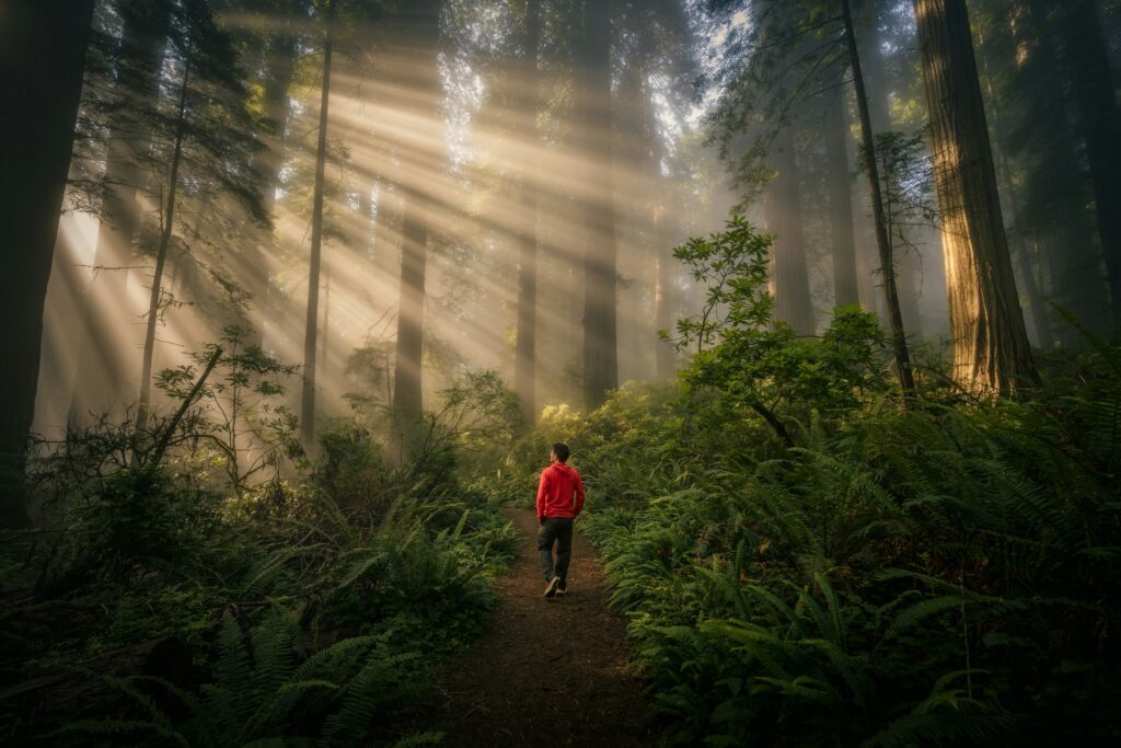
Earth does not just sit quietly beneath our feet; it moves, groans, fractures, and glows with a power that can reshape entire landscapes in a single night. From blood-red skies to rivers that suddenly vanish underground, many of the most dramatic natural spectacles are driven by forces we rarely see but constantly feel. Scientists are racing to understand these phenomena not only because they are beautiful, but because they are warnings, archives, and laboratories rolled into one. As we pack more people into coastal cities, build higher on unstable slopes, and change the climate, decoding these signals from a restless planet is becoming less a scientific luxury and more a survival skill. The question is no longer whether Earth will surprise us, but whether we will be ready when it does.
The Hidden Clues: Earthquake Lights Above a Shaking Ground
Imagine the sky flashing in eerie blue or green just minutes before the ground begins to heave: that is the unsettling reality reported during some major earthquakes. These mysterious glows, known as earthquake lights, have been described above fault zones in places as far apart as Japan, Italy, and the Americas. For decades, geologists dismissed many of these accounts as superstition or misremembered lightning, but video footage and systematic eyewitness records are changing that view. Today, researchers suspect that intense stress in certain rock types, especially those rich in quartz or basalt, can generate electrical charges that travel upward into the atmosphere. When these charges disturb the air high above a fault, they may trigger short-lived luminous displays that look like floating orbs, flickering sheets, or diffuse glows on the horizon.
These lights are more than a curiosity; they may be faint hints of what happens as Earth’s crust is driven to the breaking point. Teams studying past quakes are beginning to map where lights were seen relative to fault geometry, hoping to understand which tectonic settings are most likely to produce them. While no serious scientist claims earthquake lights can currently predict a quake, they are pushing seismology toward a more holistic view that links solid Earth physics with atmospheric electricity. The unresolved nature of the phenomenon keeps it on the line between folklore and cutting-edge science, a reminder that even in 2025, our supposedly well-known planet still keeps some of its cards hidden.
From Fire to Sky: Volcanic Lightning in Ash-Choked Plumes
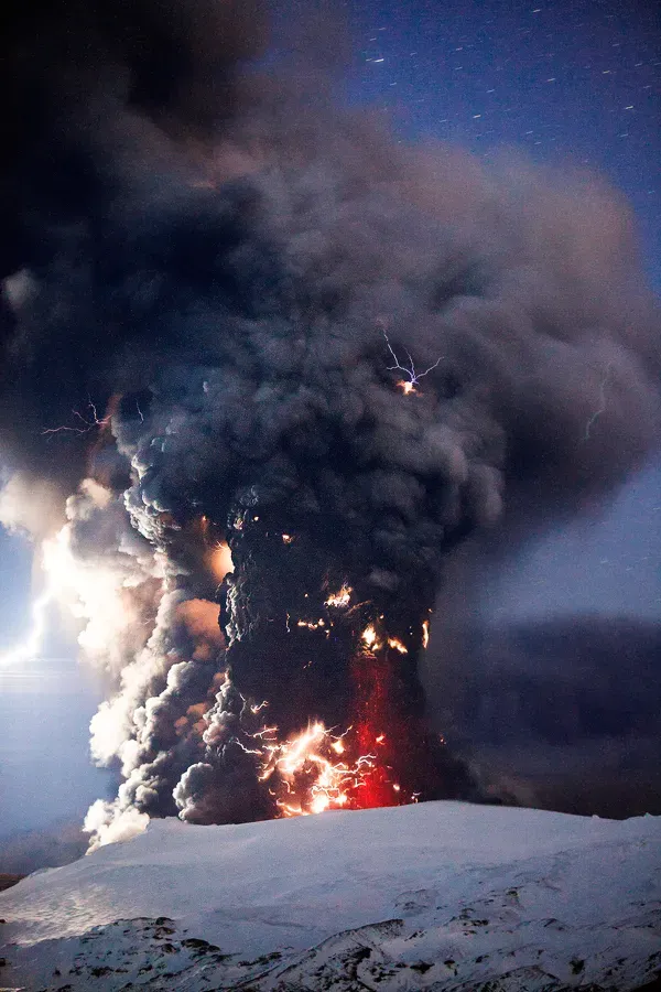
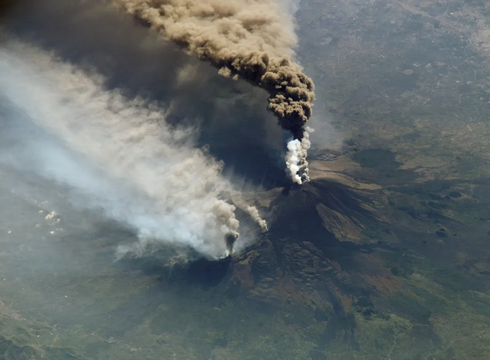
When a volcano erupts violently enough to punch a column of ash miles into the atmosphere, the resulting cloud can glow with tangled veins of lightning that rival the most intense summer storm. This is volcanic lightning, one of the most visually dramatic expressions of Earth’s raw power. Far from being a simple bolt or two, some eruptions produce branching networks that flash again and again through the plume, turning the sky into a strobe-lit cauldron. The basic physics comes down to friction: tiny ash particles collide, break apart, and separate electric charges, much like rubbing a balloon on a sweater. Once enough charges accumulate, the plume behaves like a giant battery discharging back into the surrounding air.
What looks like pure chaos is now being carefully measured with specialized lightning detection networks that can distinguish volcanic flashes from typical thunderstorms. These measurements help scientists estimate the height and density of ash plumes in real time, especially when direct visual observations are blocked by weather or darkness. That information can be critical for aviation agencies deciding whether to reroute flights to avoid ash that can clog and melt jet engines. In recent years, researchers have shown that the frequency and strength of volcanic lightning can correlate with the amount of fine ash lofted into the atmosphere, turning something visually spectacular into a data stream with real-world consequences. The same crackling light that once terrified ancient observers is now one of modern volcanology’s most dynamic tools.
Rivers That Vanish: Karst Sinkholes and Underground Worlds
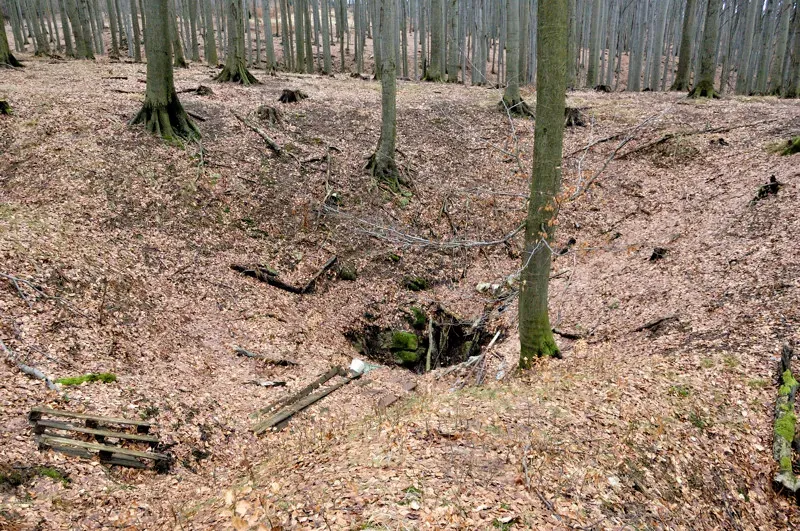
In some landscapes, a river can simply disappear, slipping into a gaping sinkhole as if the Earth had swallowed it whole. Such scenes are common in karst regions, where water has carved networks of caves and tunnels through limestone, dolomite, or gypsum over thousands to millions of years. The forces at work are slow but relentless: slightly acidic rainwater seeps into cracks, dissolving mineral grains and widening fractures grain by grain. Eventually, the ceiling of a cave can no longer support its own weight and collapses, creating a sinkhole that may be a shallow depression or a sudden, near-vertical shaft. These collapses are a stark visible sign of a hidden architecture of voids and conduits beneath everyday landscapes.
For communities built on karst, this invisible architecture can quickly turn hazardous. Roads, houses, and even entire neighborhoods have been damaged when the ground suddenly slumped into previously unknown underground chambers. Hydrogeologists and engineers are increasingly turning to tools like ground-penetrating radar and satellite-based radar interferometry to map subtle land-surface changes before catastrophic failures occur. At the same time, cave systems in karst regions preserve climate records in mineral layers known as speleothems, capturing past rainfall and temperature swings. So while sinkholes can be dangerous surprises, the same dissolution and collapse processes offer a rich archive of how Earth’s hydrological engine has shifted over time.
Frozen Sculptors: Glacial Surges and Moving Mountains of Ice
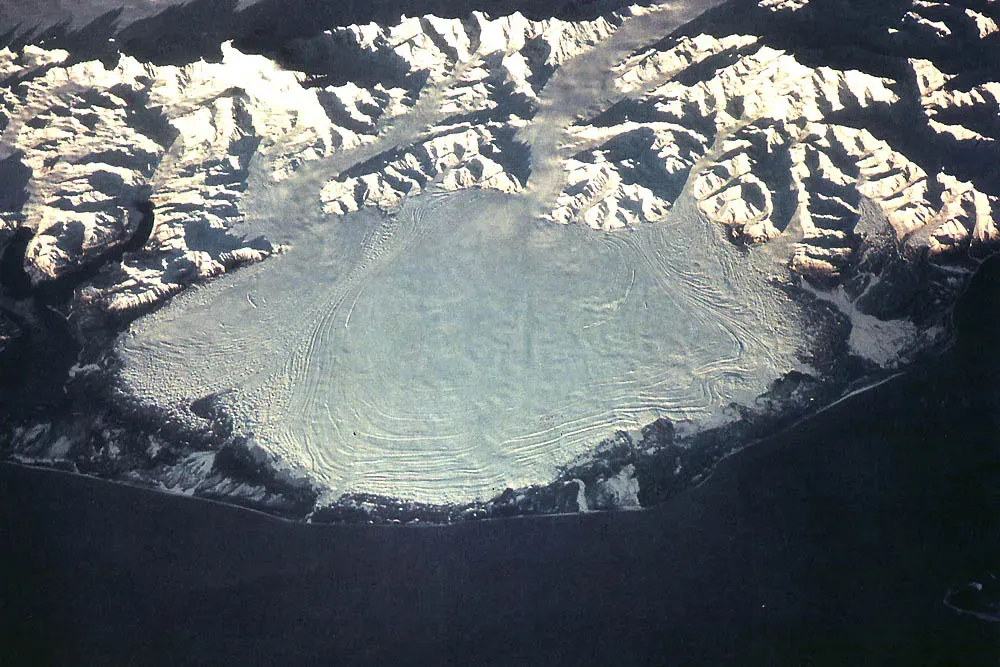
To most of us, glaciers feel like symbols of slowness, creeping down valleys over centuries with barely perceptible motion. Yet some glaciers can suddenly accelerate, racing forward in what researchers call surges that transform once-stable ice streams into grinding conveyors. During a surge, parts of a glacier may move ten or even a hundred times faster than their usual pace, plowing debris, reshaping river systems, and jamming fjords with towering ice cliffs. These rapid shifts are driven by changing water pressure at the ice-bed interface, where meltwater can act like a lubricant, and by evolving internal ice structures that respond to stress. It is a powerful reminder that even the “solid” cryosphere is anything but static.
Satellite imagery over the last few decades has given scientists unprecedented views of these icy lunges in remote ranges from Alaska to the Himalaya. Surging glaciers can dam rivers, create unstable lakes, and later unleash sudden floods that threaten downstream communities. At the same time, their behavior offers insights into how entire ice sheets might respond to warming climates, when lubrication and structural weakening could become more common. By combining field measurements, GPS tracking, and ice-flow models, glaciologists are slowly untangling the triggers and feedbacks behind surges. Understanding these frosty stampedes is no longer a niche interest; it feeds directly into forecasts of sea level, water resources, and mountain hazards in a warming world.
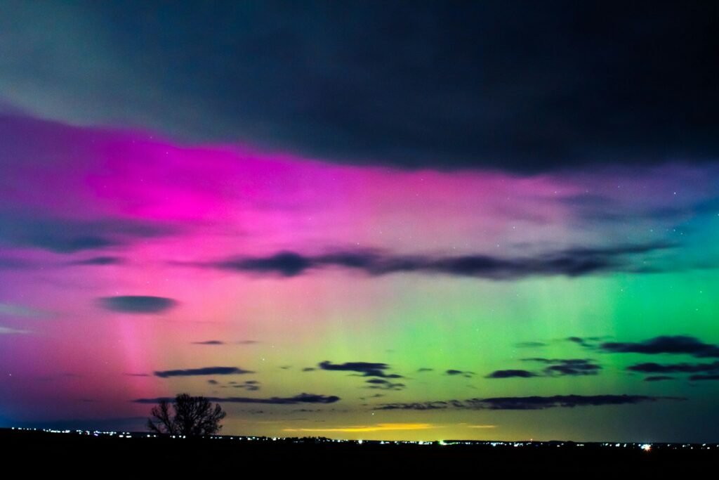
Skies on Fire: Red Sprites, Blue Jets, and High-Altitude Electric Ghosts
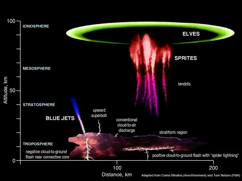
Far above the crack and rumble of familiar thunderstorms, rare flashes of crimson and blue flicker at the edge of space. These are red sprites, blue jets, and other forms of transient luminous events, electrical discharges that leap upward from storm tops instead of downward toward the ground. First captured convincingly on camera in the late twentieth century, sprites can span tens of miles across, with tendrils reaching toward the cloud top and diffuse glows extending higher into the mesosphere. Blue jets, by contrast, shoot narrower beams of bluish light from storm tops into the stratosphere at astonishing speeds. These ghostly flashes are driven by powerful lightning strokes that momentarily disturb the electric field between the atmosphere and space.
Studying these events has required a blend of astronaut observations, high-speed ground-based cameras, and specialized detectors mounted on research aircraft and satellites. What once seemed like atmospheric folklore is now recognized as an important link between weather in the lower atmosphere and the charged environment higher up. Scientists suspect that sprites and related phenomena may influence the chemistry of the upper atmosphere, altering concentrations of nitrogen oxides that, in turn, can affect ozone and radiative balance. While their global impact is still being quantified, these fleeting lights underscore a central lesson of modern geoscience: processes we once wrote off as too rare or exotic can, in aggregate, shape the planet’s energy and chemical cycles in subtle but meaningful ways.
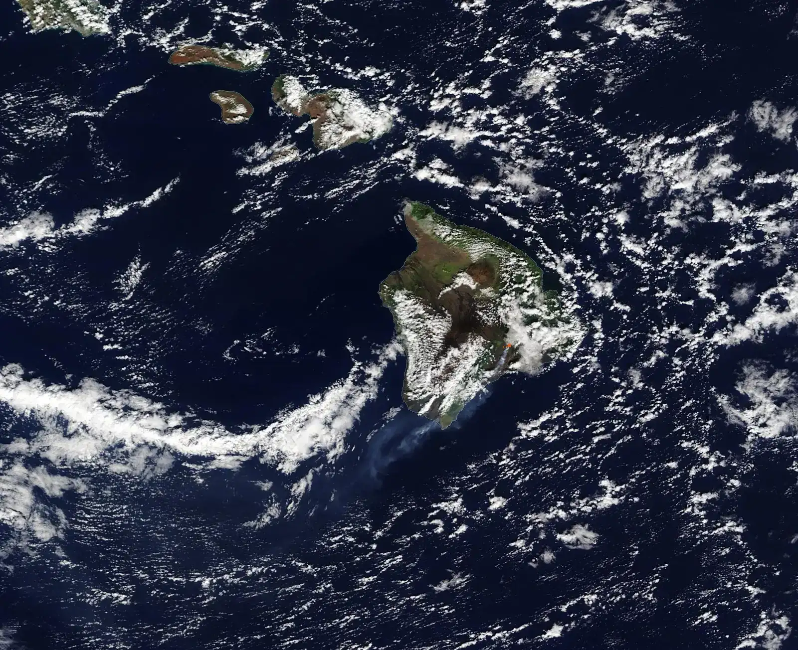
When Seas Breathe: Internal Waves and Hidden Ocean Storms
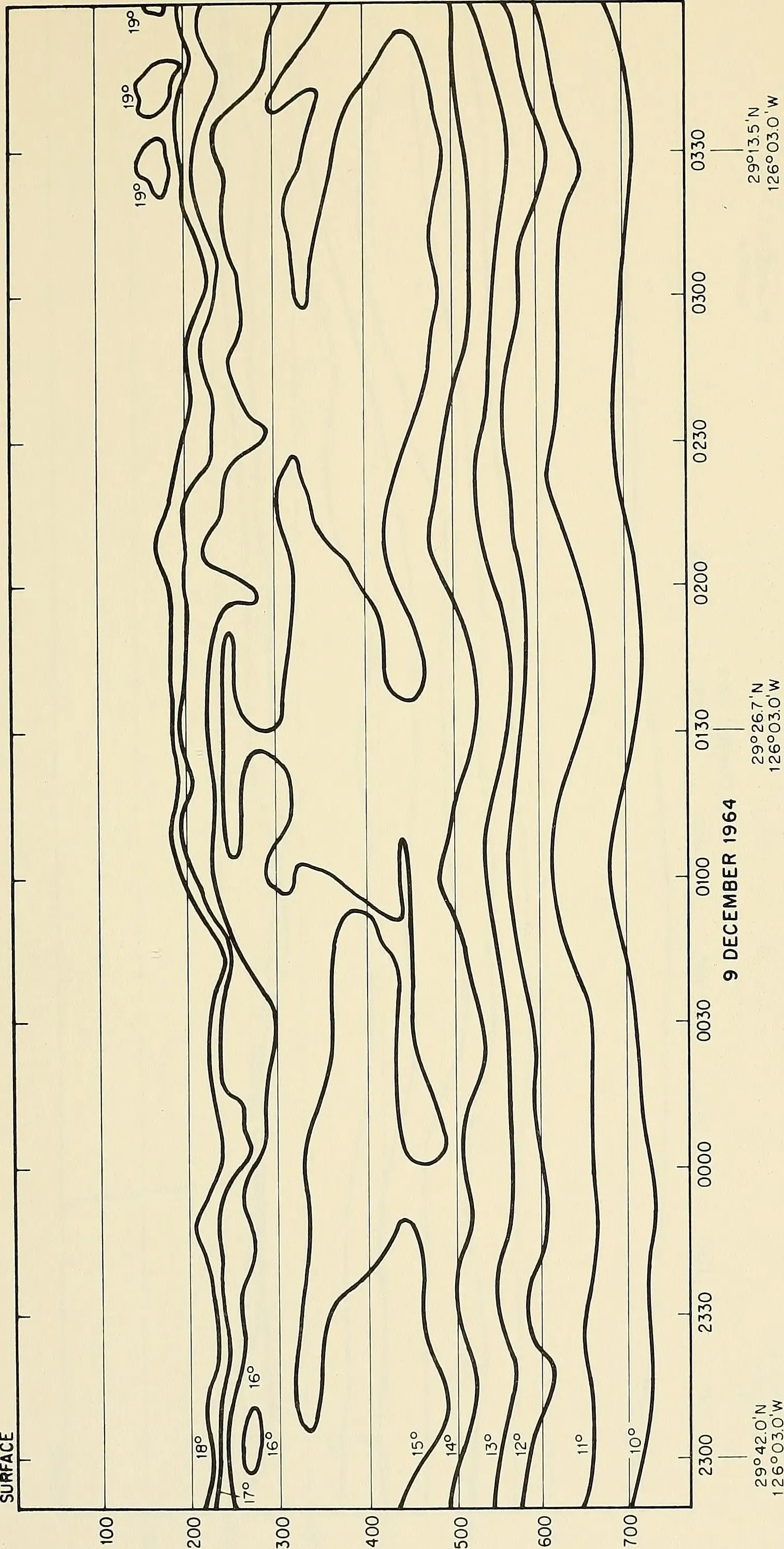
Look at the surface of a calm tropical sea from above, and you may notice vast, slowly moving bands of lighter and darker blue sweeping along like the ribs of some submerged giant. These are surface signatures of internal waves, enormous undulations that roll along boundaries between layers of different density deep within the ocean. Unlike familiar wind-driven waves, internal waves can reach hundreds of meters in height and travel for hundreds of kilometers, powered by tides interacting with seafloor ridges or by shifting currents. When these waves break, they stir colder, nutrient-rich water upward and push warmer water downward, mixing the ocean’s interior like a colossal invisible spoon. This internal churning plays a key role in regulating how heat and carbon move through the seas.
In recent years, fleets of autonomous floats, gliders, and satellites have revealed just how widespread and energetic these underwater storms can be. Their mixing helps maintain the temperature structure of the global ocean, influencing climate patterns from monsoons to El Niño events. Internal waves also affect submarine navigation and offshore engineering by changing local density and current profiles in ways that can stress cables, pipelines, and platforms. Oceanographers are now working to incorporate more realistic internal wave physics into global climate models, since underestimating their mixing power can skew predictions of how fast the deep ocean will warm. The gentle ripples we see from space, in other words, hint at a hidden engine quietly helping set the thermostat for the entire planet.
Why It Matters: Reading a Restless Planet in a Time of Change
At first glance, a crackling volcanic plume or a flicker of light above a storm might seem like mere spectacle, the sort of thing that fills social media feeds and then vanishes. But taken together, natural phenomena driven by Earth’s powerful forces are part of a living diagnostic system, revealing how energy moves through rock, water, ice, and air. They complement traditional measurements like seismographs, tide gauges, and weather balloons by capturing extremes, thresholds, and rare events that standard monitoring can miss. Compared with older approaches that focused on single disciplines, today’s research treats these displays as interfaces where geology, physics, chemistry, and biology all intersect. Ignoring them would be a bit like a doctor discarding the most dramatic symptoms and focusing only on blood pressure readings.
There is also a human dimension that goes far beyond scientific curiosity. As populations rise along coasts, river deltas, and mountain valleys, people are increasingly exposed to hazards that manifest through exactly these phenomena: surging glaciers, collapsing sinkholes, ash-rich eruptions, and energetic storms. Understanding how and when these displays arise allows for earlier warnings, smarter building codes, and more realistic risk assessments. In education and communication, these dramatic effects can act as gateways, drawing students into deeper engagement with science that might otherwise feel abstract. The same forces that can destroy infrastructure can also build scientific literacy and, in the long run, resilience.
From Ancient Wonder to Modern Instrument: How We Study Earth’s Extremes
For most of human history, red skies, trembling ground, and vanishing rivers were folded into myth, ritual, or local lore, explanations that stressed meaning rather than mechanism. The modern scientific era did not erase that sense of wonder so much as redirect it, replacing divine anger with plate tectonics, fluid dynamics, and electromagnetism. What has changed most radically in recent decades is the scale and speed at which we can observe these forces at work. High-resolution satellites now track ash plumes, glacial fronts, and internal waves in near real time, while dense sensor networks capture the tiny vibrations and fields that precede larger events. Even smartphones have become accidental instruments, as their accelerometers and cameras contribute to crowdsourced earthquake data and aurora reports.
This technological shift has blurred the boundary between observer and participant. Local communities report unusual ground cracks, discolored water, or strange lights that feed into global databases used by hazard agencies. Drones peek into volcanic craters that would be too dangerous for human pilots, while ocean robots dive into storm-forced seas to measure turbulence where ships cannot safely go. Compared with older, more static maps of risk, dynamic monitoring captures how Earth’s forces evolve with seasons, climate shifts, and human alterations to the landscape. In effect, we are building a planetary dashboard that turns once isolated wonders into continuous streams of information. It is a far cry from ancient sky watchers, yet driven by the same urge: to make sense of a world that can turn from calm to catastrophic in an instant.
The Future Landscape: Forecasting a Hotter, More Energetic Earth
Looking ahead, nearly every major natural force on this list is expected to interact in new ways with a warming climate and expanding human footprint. As oceans absorb more heat, internal waves and mixing patterns may shift, altering how quickly the deep sea takes up excess warmth. Retreating glaciers will likely produce more unstable slopes and glacial lakes in the short term, raising the odds of sudden floods and debris flows in some mountain regions. Changing rainfall patterns could influence sinkhole risk in karst terrains, as prolonged droughts are followed by intense downpours that rapidly recharge underground voids. Volcanic activity itself is not driven by climate, but the impacts of eruptions on heavily populated, highly networked societies can grow more severe as infrastructure becomes more interconnected.
On the technology front, scientists are aiming for earlier and more reliable warnings by fusing satellite data, ground sensors, and machine-learning models. Experimental approaches include algorithms that sift through tiny fluctuations in seismic noise for early hints of fault slip, as well as real-time ash-plume lightning analysis that can automatically trigger aviation alerts. In the upper atmosphere, new satellite constellations will track transient luminous events on a global scale, clarifying how often they occur and what they mean for atmospheric chemistry. The challenge will be balancing an avalanche of data with the practical need for clear, timely decisions that protect people without generating constant false alarms. As Earth’s forces continue to express themselves in surprising ways, our ability to live with them will depend as much on social and political choices as on scientific breakthroughs.
How to Stay Engaged: From Awe to Action
For most readers, the idea of contributing to research on earthquake lights or internal waves might feel out of reach, but the gap between expert and observer is narrowing. Citizen science platforms increasingly invite people to report unusual sky glows, mudflows, or ground cracks, creating valuable datasets that professionals alone could never assemble. Simple steps such as learning your local hazard map, knowing whether you live on karst terrain or near glacial valleys, and following trusted scientific institutions can make natural phenomena feel less like random shocks and more like part of a knowable system. Supporting public investment in satellites, monitoring networks, and open data may not seem as tangible as building a levee, yet those tools often provide the first hints that something big is coming. Even small acts, like talking with kids about how volcanoes really work or why the ocean is layered, can seed a more scientifically literate next generation.
Ultimately, paying attention is its own form of preparedness. The more we learn to read the signs in the sky, the sea, the ice, and the rock, the less these extraordinary events feel like distant curiosities and the more they resemble an ongoing conversation with the planet we depend on. Awareness does not eliminate risk, but it changes how we experience it, shifting the story from helplessness to informed vigilance. Next time a news clip shows lightning snarling through a volcanic plume or a river abruptly vanishing into limestone, there is an opportunity to look twice and ask what deeper forces are on display. That habit of questioning, of looking beneath the spectacle, is where awe and understanding meet.

Suhail Ahmed is a passionate digital professional and nature enthusiast with over 8 years of experience in content strategy, SEO, web development, and digital operations. Alongside his freelance journey, Suhail actively contributes to nature and wildlife platforms like Discover Wildlife, where he channels his curiosity for the planet into engaging, educational storytelling.
With a strong background in managing digital ecosystems — from ecommerce stores and WordPress websites to social media and automation — Suhail merges technical precision with creative insight. His content reflects a rare balance: SEO-friendly yet deeply human, data-informed yet emotionally resonant.
Driven by a love for discovery and storytelling, Suhail believes in using digital platforms to amplify causes that matter — especially those protecting Earth’s biodiversity and inspiring sustainable living. Whether he’s managing online projects or crafting wildlife content, his goal remains the same: to inform, inspire, and leave a positive digital footprint.