Somewhere between satellite imagery and jungle mist, entire cities are appearing on maps that, until recently, showed nothing but blank green. Archaeologists are uncovering vast urban centers in places long written off as untouched wilderness, and the discoveries are rewriting what we thought we knew about “civilization.” These are not small villages or scattered shrines, but complex, engineered landscapes that rival the world’s great ancient capitals. Yet many questions remain painfully open: who built them, how did they thrive in such hostile environments, and why did they vanish so completely that even their memory dissolved? As new tools scan the Earth’s surface like an X-ray, the story is becoming richer, stranger, and far more human than anyone expected.
The Hidden Canals Beneath the Amazon Canopy
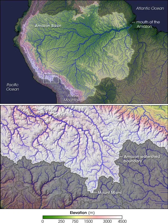
For generations, textbooks painted the Amazon as a largely untouched rainforest dotted only with small, mobile communities. That idea is collapsing under the weight of new evidence showing buried causeways, earthworks, and geometric enclosures spread across thousands of square miles. Using laser-based LiDAR scanning from aircraft, researchers are mapping raised roads and canal systems that suggest dense populations and carefully planned urban layouts in western Amazonia. Some sites show interconnected platforms and ditches that look less like scattered hamlets and more like a sprawling garden-city network. The shock is not only that these cities existed, but that they survived for centuries in a place modern engineers often consider too wet, too unstable, and too remote for sustained urban life.
Much of this infrastructure is still invisible from the ground, smothered by centuries of regrown forest and river silt. Soil samples show signs of human-engineered “dark earths” rich in charcoal and nutrients, implying deliberate, long-term management of the land, not short-lived slash-and-burn. To me, this flips the old narrative completely: instead of a pristine forest shaping people, it looks like people were shaping a semi-domesticated forest. Yet no written records remain from these city-builders, and even their regional names are lost, which makes the scale of their disappearance feel eerie. Standing on a muddy riverbank today, it’s unsettling to realize that beneath your boots may lie the main avenue of a vanished metropolis.
Lost Causeways of the Maya’s Hidden Megacities
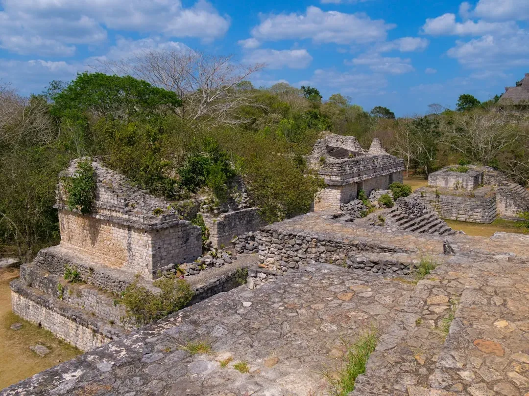
In Central America, new surveys are revealing that classic Maya cities like Tikal and Caracol were only the tip of a much larger urban iceberg. High-resolution LiDAR has exposed thousands of previously unknown structures, defensive walls, and raised roads called sacbeob that knit together what now looks like a true urban region rather than isolated ceremonial centers. In one major project, researchers mapped an area and found evidence of dense settlement features that suggest populations far larger than earlier estimates. This transforms jungles of Guatemala, Belize, and Mexico into something akin to a buried web of suburbs, highways, and fortified hubs. It’s as if someone dimmed the lights on an entire civilization centuries ago and only now is science slowly turning the dimmer back up.
Yet practical questions pile up: how did these cities support such large populations in a landscape prone to droughts and thin soils? Archaeologists are seeing intricate water reservoirs, terraced fields, and managed forests that point to sophisticated environmental engineering. At the same time, pollen records and sediment cores hint at deforestation and drying trends that may have undermined that delicate system. I find it especially striking that ancient Maya planners were solving urban congestion, water security, and food production in ways that echo modern debates over sustainable cities. But we still cannot fully connect the dots between climatic stress, political turmoil, and the final abandonment of many of these urban hubs, and that uncertainty keeps the story both scientific and haunting.
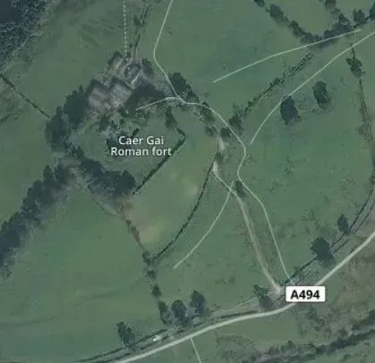
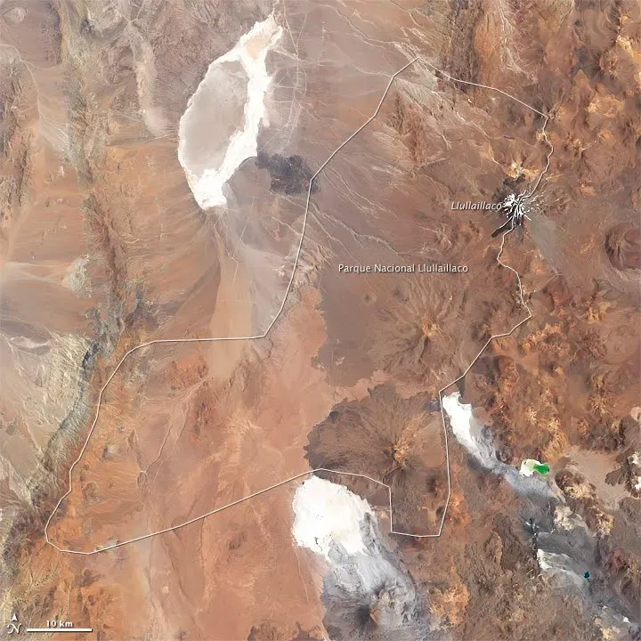
Desert Lines and Vanished Cities Along the Andes
The high deserts of Peru and northern Chile have long been associated with mysterious geoglyphs and isolated ruins, but the picture is growing more complex. Satellite imaging and on-the-ground surveys are uncovering forgotten urban centers tucked into dry valleys, often overshadowed by better-known sites like Machu Picchu or Chan Chan. Some of these cities appear to have coordinated irrigation canals carved into near-sterile desert soil, allowing intensive agriculture in places that today look utterly lifeless. You can almost imagine the shock an early explorer must have felt, stumbling across stone walls and plazas surrounded by glaring, empty sand. These places raise hard questions about resilience and failure when turns against human engineering.
Archaeologists are now tying together scattered clues: collapsed canal systems, abrupt changes in building style, and layers of flood debris linked to powerful El Niño events. In some valleys, traces of once-thriving neighborhoods simply stop, as if someone threw a switch on urban life. Were these centers undone by climate swings, internal conflict, shifting trade routes, or all of the above? The frustrating truth is that we may never get tidy answers, only patterns and probabilities drawn from damaged layers of earth. And yet, every time a faint grid of walls appears in new satellite data, it feels like a silent argument against the idea that deserts are empty by default.
Sunken Hints of Ancient Cities Off Hidden Coasts
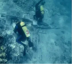
Moving off the continents, coastlines conceal some of the most dramatic and least understood traces of lost urban worlds. As sea levels rose after the last ice age, low-lying settlements and perhaps full-fledged cities would have been drowned, their streets now lying beneath dozens of meters of water. Divers and marine archaeologists have documented submerged stone structures, harbor works, and road-like features off coasts in regions from the Mediterranean to parts of the Indian Ocean. These finds are often fragmentary, warped by currents and marine life, but they hint at a broader story: ancient people built big and built close to the water, just as we do today. When the sea advanced, their urban footprints slipped beyond the easy reach of traditional archaeology.
Modern sonar and autonomous underwater vehicles are slowly bringing these drowned landscapes back into focus. Detailed seafloor maps can reveal geometric formations that stand out from natural rock, guiding targeted dives that sometimes confirm artificial construction. From a scientific point of view, this is one of the most challenging frontiers – marine work is costly, slow, and limited by visibility and depth. I find it sobering that some of the most important chapters in human urban history might currently be accessible only a few weeks a year when conditions allow. For now, these hidden coastal cities remain more rumor than roster, a vast dataset waiting patiently beneath the waves.
Hidden Grids in African Savannas and Forests
Across parts of sub-Saharan Africa, the old idea that precolonial societies were mostly small-scale or “stateless” is being sharply revised. Fieldwork combined with aerial and satellite surveys is revealing complex settlement systems: walled compounds, earthworks, and faint rectilinear patterns that suggest planned urban layouts. Some regions show evidence of sprawling settlement clusters with roads or paths linking them, functioning almost like urban belts rather than single dense city centers. These patterns often lie disguised beneath grasslands, farmland, or secondary woodland, making them easy to miss without modern sensing tools. The impression is of a continent whose urban history has been heavily underestimated, not because the cities were small, but because their remains are subtle.
In many cases, written records from neighbors or later visitors are sparse, biased, or focused on trade and politics rather than the nuts and bolts of everyday urban life. Archaeologists rely on ceramics, metallurgy remains, and charcoal dating to piece together timelines that often run for many centuries. From my perspective, what’s most striking is how diverse these African urban systems appear: some are heavily fortified, others are open and dispersed; some emphasize monumental architecture, while others prioritize landscape engineering. The word “city” itself starts to feel too narrow, shaped by European stone-built examples rather than the varied ways humans have clustered together. These hidden grids are not just filling blank spots on the map – they are demanding a rewrite of what we think “urban” can even mean.
Forest Cities in Southeast Asia’s “Empty” Highlands
In the highlands and plateaus of Southeast Asia, what used to be dismissed as scattered temple ruins are now being reinterpreted as fragments of massive, low-density cities. Around famous sites such as Angkor in Cambodia, LiDAR surveys have revealed a web of roadways, reservoirs, field systems, and residential mounds stretching far beyond the monumental cores. Similar patterns are emerging at other, less-known locations, indicating that Angkor may not have been a rare exception but part of a broader regional tradition of hydraulic, forest-embedded urbanism. On the ground, much of this infrastructure looks like lumpy terrain or small ponds until the data is layered together. It’s the kind of puzzle where only a bird’s-eye view shows you there was once a city beneath the trees.
Urban planning here was deeply tied to water control: baray reservoirs, canals, and moats that managed monsoon floods and dry-season shortages. When that finely tuned system faltered – due to climate shifts, sedimentation, or political upheaval – the entire urban ecology may have become fragile. Archaeologists examining tree rings and sediment layers see echoes of prolonged droughts, interspersed with intense flooding, that would challenge even modern infrastructure. I still remember the first time I saw a LiDAR visualization of Angkor: the jungle suddenly turned transparent, and a ghost city of embankments and grids popped into view. It drives home how misleading the word “ruin” can be when most of the city is, quite literally, still hiding in plain sight.
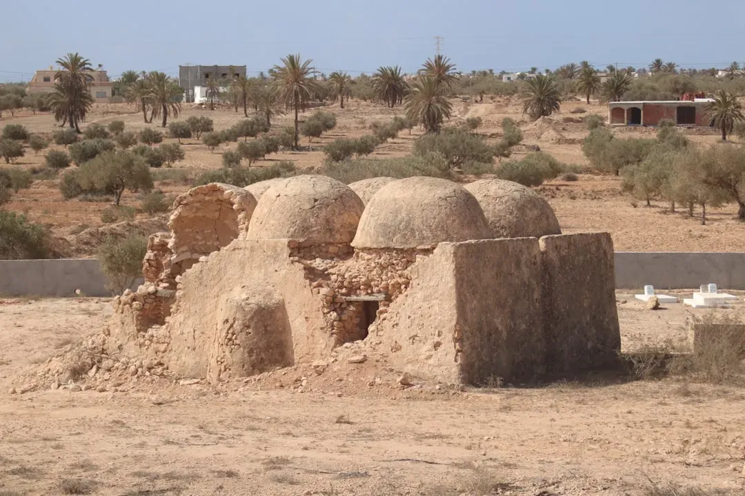
Ghost Grids in the World’s Drylands
In deserts and semi-arid regions on multiple continents, satellite imagery keeps turning up faint, geometric marks that experts are still arguing about. Some look like field systems or corrals, others like foundations of vanished towns or caravan hubs along ancient trade routes. In places where wind and erosion strip away vegetation, buried walls can create subtle color and texture differences that only show up from a high, data-rich vantage point. Aerial archaeologists have identified hundreds, even thousands, of these features in stretches of land previously labeled as marginal or empty. Yet ground truthing them – actually going out, digging, dating, and interpreting – lags far behind the discovery rate.
This mismatch between remote sensing and hands-on archaeology feels like a generational challenge. A researcher might flag dozens of promising sites in a single satellite sweep, but local teams can reasonably excavate only a handful in a season. That means many potential ancient cities, trading stations, or fortresses remain little more than ghost grids on a computer screen. For now, the story of these dryland networks is written more in pixels than in pottery shards or inscriptions. Still, each verified site supports the same underlying message: humans have been far more willing and able to build big in tough landscapes than our older histories allowed.
Why These Hidden Cities Matter
All of these discoveries, spread across jungles, deserts, coasts, and highlands, converge on a single, unsettling truth: our mental map of the human past has been dramatically incomplete. For a long time, scholars leaned on visible stone monuments, written texts, and easily accessible ruins to tell the story of “civilization.” That naturally favored regions where building materials, climate, and later history happened to preserve those traces. The newly revealed cities – often earth-built, forest-entangled, or partly drowned – show how biased that record has been. They hint that the total number of urban experiments humans have run on this planet may be far larger than anyone guessed a few decades ago.
This matters for more than just filling in blanks on a timeline. These hidden cities offer case studies in how societies manage water, soil, forests, and trade under pressures that feel strikingly familiar to us in 2025. Some apparently found long-term balance with their environments; others overshot, degraded their support systems, and declined. Comparing these ancient strategies with modern urban planning gives us a deeper, more sobering data set than any computer model alone could provide. To me, the most powerful shift is conceptual: instead of seeing the past as a ladder toward our present, we start seeing it as a crowded landscape of different paths, many of which ended in silence.
The Future Landscape of Discovery
Right now, it feels as if we’re in the early chapters of a new era of archaeological discovery powered less by shovels and more by sensors. Cheaper LiDAR, increasingly detailed commercial satellite imagery, and machine-learning tools that can flag suspiciously regular shapes are accelerating the hunt for hidden cities. In the near future, drones equipped with multi-spectral cameras might sweep remote valleys or canopy gaps in hours instead of weeks, feeding algorithms that highlight likely structures in near real time. Underwater, autonomous robots can already map seafloors in high resolution, and advances in battery life and navigation will only push that frontier deeper. The result is a world in which whole regions that once seemed archaeologically “quiet” could suddenly light up as potential urban zones.
But there are serious challenges alongside the excitement. Many of these sites lie in politically fragile areas, threatened by looting, development, or climate-driven disasters such as floods and wildfires. Local communities and governments will need to be central partners in deciding what to excavate, what to protect, and how to balance heritage with present-day needs. There’s also a risk that shiny new technologies overshadow slower, community-grounded research that actually makes sense of the data. The most hopeful vision is a blended one: satellites and algorithms spotting the outlines, and local archaeologists, historians, and residents filling those outlines with stories, objects, and meaning. If that balance holds, the next few decades could reveal an entire hidden chapter of urban history that we barely suspected was there.
How Readers Can Engage with Hidden Ancient Cities
You don’t need a research grant or a seat on a jungle-bound helicopter to be part of this unfolding story. One simple step is to support responsible science reporting and public archaeology projects that highlight lesser-known regions, not just the same handful of famous ruins. Many institutions and local museums now offer virtual tours and open-access dig diaries that let you follow discoveries season by season. When you travel, choosing guides and operators who work with archaeologists and local communities helps fund preservation rather than damage. Even small actions, like questioning simplistic narratives about “empty lands” or “untouched wilderness,” can shift public expectations about where cities could have been.
On a more concrete level, citizen science projects sometimes invite volunteers to scan satellite tiles online and flag potential archaeological features, turning idle screen time into useful data. Educators can fold these new findings into classrooms, giving students a more global and varied picture of how cities have looked and functioned through time. And in conversations about climate and urban planning today, you can bring up the deep-time examples hiding in rainforests, deserts, and drowned coasts as reminders that our own cities are part of a much longer, more experimental story. The next hidden metropolis might be spotted first on someone’s laptop in a suburban living room. It’s worth asking yourself: if a lost city lay just beneath the canopy or just off your favorite beach, would you want to know?

Suhail Ahmed is a passionate digital professional and nature enthusiast with over 8 years of experience in content strategy, SEO, web development, and digital operations. Alongside his freelance journey, Suhail actively contributes to nature and wildlife platforms like Discover Wildlife, where he channels his curiosity for the planet into engaging, educational storytelling.
With a strong background in managing digital ecosystems — from ecommerce stores and WordPress websites to social media and automation — Suhail merges technical precision with creative insight. His content reflects a rare balance: SEO-friendly yet deeply human, data-informed yet emotionally resonant.
Driven by a love for discovery and storytelling, Suhail believes in using digital platforms to amplify causes that matter — especially those protecting Earth’s biodiversity and inspiring sustainable living. Whether he’s managing online projects or crafting wildlife content, his goal remains the same: to inform, inspire, and leave a positive digital footprint.