They rise out of deserts, glow beneath the oceans, and twist into shapes that seem to mock everything geology textbooks promise about order and predictability. Around the world, a handful of rock formations continue to baffle researchers, refusing to fit neatly into known processes of erosion, uplift, and volcanism. In some cases, the physics looks off; in others, the timing makes no sense at all. These landscapes are not just pretty backdrops for photos – they are open questions carved into stone. As scientists refine satellite imaging, dating techniques, and geochemical tools, the mysteries deepen instead of disappearing, forcing us to ask an uncomfortable question: how much of Earth’s story do we still not understand?
1. The Eye of the Sahara: A Bullseye No One Saw Coming
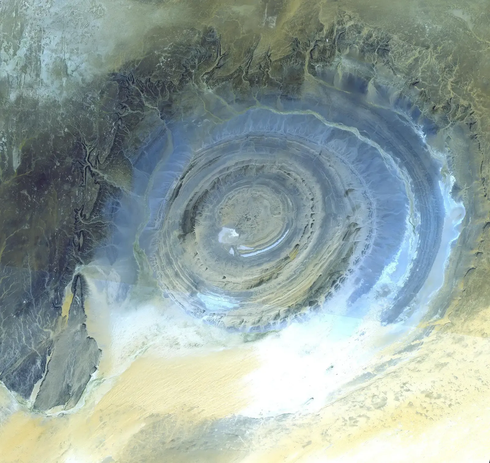
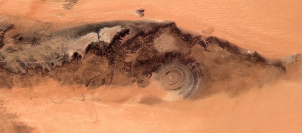
The Richat Structure, better known as the Eye of the Sahara, looks like something designed, not eroded. From the ground in Mauritania, it’s a jumble of ridges and rock; from space, it’s a near-perfect spiral bullseye more than 25 miles across, so distinctive that early astronauts used it as a landmark. The official explanation is that it formed as a deeply eroded, uplifted dome composed of different rock layers, each weathering at slightly different rates. Yet its symmetry, concentric rings, and chemical fingerprints have kept the door open to lingering questions about how such a structure grows and collapses over deep time. I remember the first time I saw a satellite image of it and instinctively thought of a fossilized hurricane frozen mid-spin.
Part of the mystery lies in the mismatch between what geologists expect from a simple dome and what they actually see in the Eye’s internal structure. The exposed rocks span hundreds of millions of years of Earth’s history, but the patterning seems almost too tidy for a chaotic combination of erosion and tectonics. Some researchers have proposed that the Eye might once have been a massive volcanic structure, while others see it as a deeply eroded impact feature that has lost the clean signature of a crater. Neither theory fully fits the data so far, particularly when it comes to the absence of definitive high-pressure impact minerals or an obvious volcanic plumbing system. For now, the Eye sits in the middle of the Sahara, looking back at our uncertainty.
2. The Sailing Stones of Death Valley: Rocks That Move Themselves
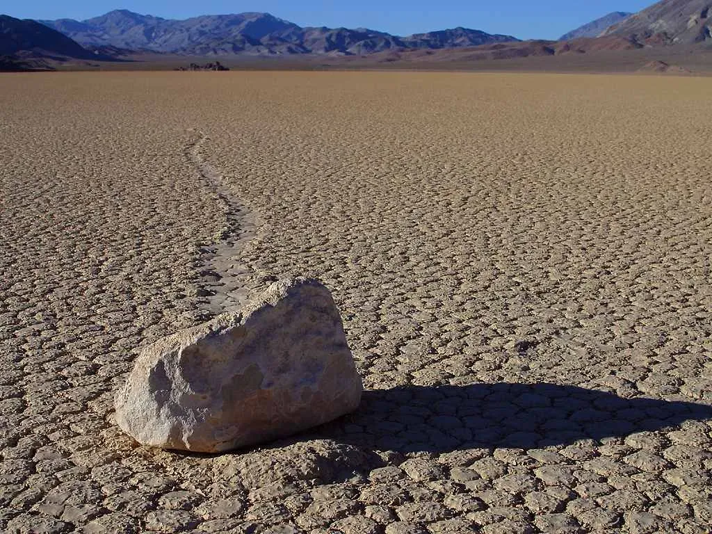
On the cracked clay of Racetrack Playa in California’s Death Valley, heavy rocks carve long, winding trails across the lakebed, as if something invisible has dragged them. For decades, park rangers, geologists, and visitors stared at these “sailing stones” and argued about the cause: powerful winds, sheets of ice, even pranksters. Time-lapse GPS studies in the past decade revealed a partial answer – thin panels of ice can form under the right winter conditions, allowing rocks to slide when pushed by light winds across the slick mud. That sounds tidy, but it still leaves questions about why only certain stones move, why their paths sometimes diverge sharply, and why similar conditions in other dry lakes rarely produce such dramatic tracks. The physics works on paper, yet the phenomenon remains oddly local and strangely temperamental.
On paper, the ingredients for rock motion look straightforward: shallow water, overnight freezing, sunny mornings to crack the ice, and just enough wind to nudge floating ice sheets that cradle embedded stones. In reality, field teams have only caught a few modest movements on instruments, often just inches at a time, not the sweeping, graceful lines that can extend for dozens or even hundreds of feet. Some trails curve, intersect, or abruptly stop in ways that suggest subtle variations in mud strength or microtopography that scientists have yet to fully map. When you stand out there, staring at a boulder that clearly moved far beyond what your own strength could manage, the official explanation feels just plausible enough – and just incomplete enough – to keep you looking over your shoulder at the empty horizon.
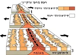
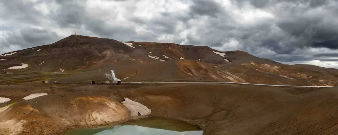
3. The Hexagonal Giant’s Causeway: Nature’s Uncanny Geometry
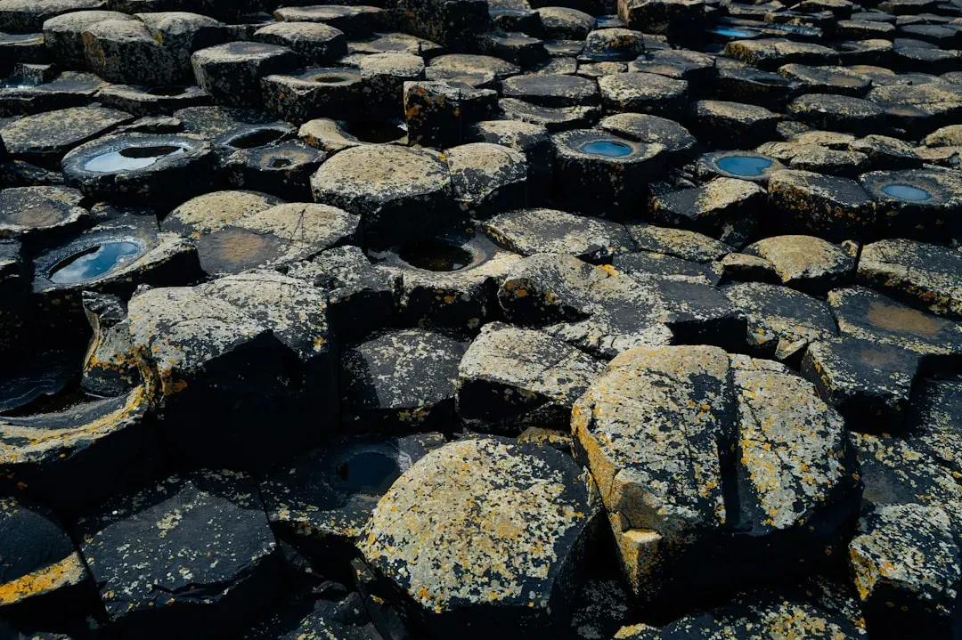
Along the coast of Northern Ireland, roughly forty thousand interlocking basalt columns rise from the sea like a tessellated staircase, most of them with nearly perfect hexagonal cross-sections. Standard geology says these columns formed when a thick lava flow cooled, shrank, and cracked, with the stress distributing into a honeycomb pattern much like dried mud. The same process is seen in other volcanic landscapes, such as Iceland and parts of the American West. But what continues to puzzle researchers is the extraordinary regularity and scale of the Giant’s Causeway, where column widths and angles align with a precision that feels more architectural than accidental. Standing on them, you can’t help feeling as if someone designed a black stone piano and then abandoned it to the tide.
Mathematical models of cooling lava can recreate hexagonal cracking, but they struggle with predicting the exact column width, height, and the transition from chaotic to ordered patterns. The physics of how microscopic fractures organize into large-scale geometry remains an active research area, bridging volcanology, materials science, and even engineering. Small changes in cooling rates, lava chemistry, and water interaction may dramatically change the final pattern, yet field data are sparse and hard to control. In other words, we know the broad strokes but still lack a detailed script for how this specific coastline achieved such disciplined geometry. That gap between theory and reality keeps the Causeway firmly on the list of geological wonders that look solved until you start asking precise questions.
4. Siberia’s Batagaika Crater: A “Mega-Slump” That Shouldn’t Grow So Fast

In northeastern Siberia, the Batagaika “crater” is less a hole in the ground than an open wound slicing into permafrost. Technically a thermo-karst depression caused by warming temperatures and collapsing frozen soils, it has been expanding at a rate that has shocked scientists tracking climate change in the Arctic. The walls of the slump expose ancient layers of sediment and ice, revealing not only long-buried forests and animal remains but also climate records stretching back tens of thousands of years. What troubles researchers is not that such features exist, but how quickly this one is evolving and how deep the collapse may eventually go. It feels like watching a slow-motion geological landslide unfold in real time rather than over millennia.
While the basic trigger – rising temperatures destabilizing ice-rich ground – is understood, the precise feedback loops that control Batagaika’s growth are not. As more ice melts, the ground lowers, creating a heat-trapping bowl that accelerates further thawing and releases greenhouse gases. Yet estimates of how much ancient carbon might be liberated from such features vary widely, and existing climate models are only beginning to account for these rapid permafrost failures. Batagaika is also revealing unexpected structural quirks in Siberian permafrost, with buried ice wedges and ancient riverbeds shaping the way the slump fractures and spreads. In a sense, it is both a geological mystery and a warning sign, reminding us that Earth’s “solid” ground can respond to warming in ways we are not fully prepared to predict.
5. Karst Towers and Stone Forests: Gravity-Defying Spires
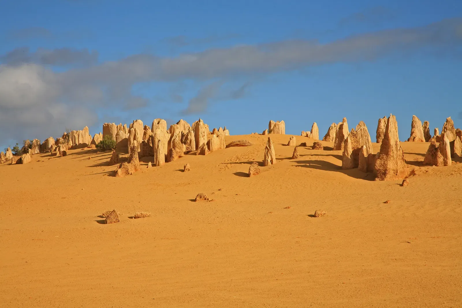
From China’s Stone Forest to the jagged limestone towers of Vietnam’s Ha Long Bay and Madagascar’s Tsingy, karst landscapes sometimes look like they were carved by an artist with a taste for the impossible. These needle-like pillars and razor-edged ridges form when slightly acidic water dissolves soluble rocks such as limestone or dolomite over long periods. The textbook description is simple: water seeps, rock dissolves, voids form, and erosion sculpts what remains. On the ground, though, the resulting shapes often seem to ignore gravity, with delicately balanced pinnacles and thin stone bridges that should, by all intuitive accounts, have collapsed long ago. When I hiked through one such forest of rock, it felt less like geology and more like walking through a frozen storm of stone waves.
Researchers studying karst have good models for large-scale cave systems and sinkholes, yet the fine-scale forms of these exotic pinnacles still defy easy prediction. Slight variations in fracture patterns, rock purity, vegetation, and even microbial communities can radically reshape how the stone dissolves and undercuts itself. In some regions, weather patterns drive alternating wet and dry cycles that etch the rock with an almost rhythmic precision, while nearby areas with similar rock show much blander terrain. Scientists can simulate general patterns in the lab, but reproducing the exact complexity seen in the field remains out of reach. The result is that these dramatic stone forests sit at the intersection of geology, chemistry, and biology, with processes so intricately entangled that no single discipline can comfortably claim to explain them.
6. Subglacial Lakes in Antarctica: Hidden Basins That Should Be Frozen Solid
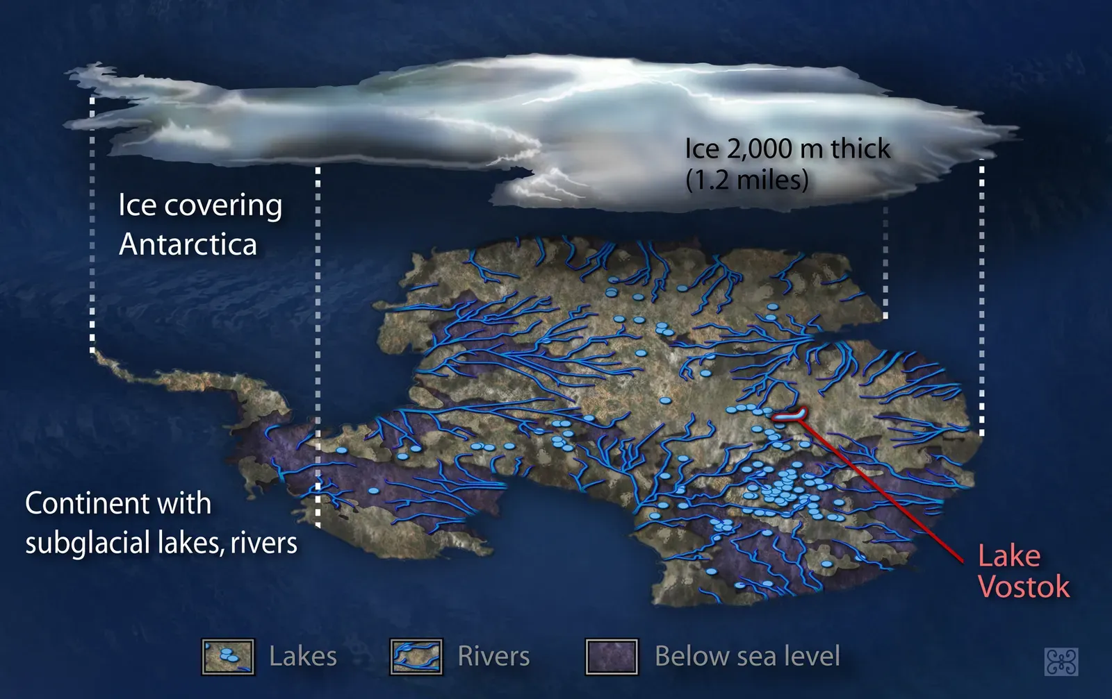
Deep beneath the Antarctic ice sheet, more than four hundred subglacial lakes have been detected using radar and satellite measurements, some of them larger than major surface lakes. Take Lake Vostok, buried under more than two miles of ice and sealed off from the atmosphere for perhaps millions of years. In theory, such depths and isolation should make these basins simple: just pockets of water held in place by pressure and geothermal heat. In practice, they behave in surprising ways, with water levels rising and falling, lakes draining and refilling, and whole networks of hidden rivers sloshing beneath the continent. The dynamic behavior of this under-ice plumbing system challenges basic assumptions about how stable ice sheets really are.
Geophysicists can explain some of the motion as gravity-driven flow over uneven bedrock, lubricated by thin films of meltwater, yet measurements keep revealing abrupt changes that do not fit smooth, gradual models. Some lakes appear to empty into others over short timescales, hinting at shifting pathways that we have never directly observed. The chemistry of these waters, inferred from rare samples and indirect signals, suggests complex interactions between rock, ice, and microbial life in conditions once thought nearly inert. That raises questions not only about Earth but also about icy moons like Europa and Enceladus, where similar sub-ice oceans may exist. Every radar pass over Antarctica seems to confirm that what we once considered a frozen, static underside is in fact a restless, mysterious aquatic world.
7. The Patomskiy “Crater”: A Cone With No Clear Culprit
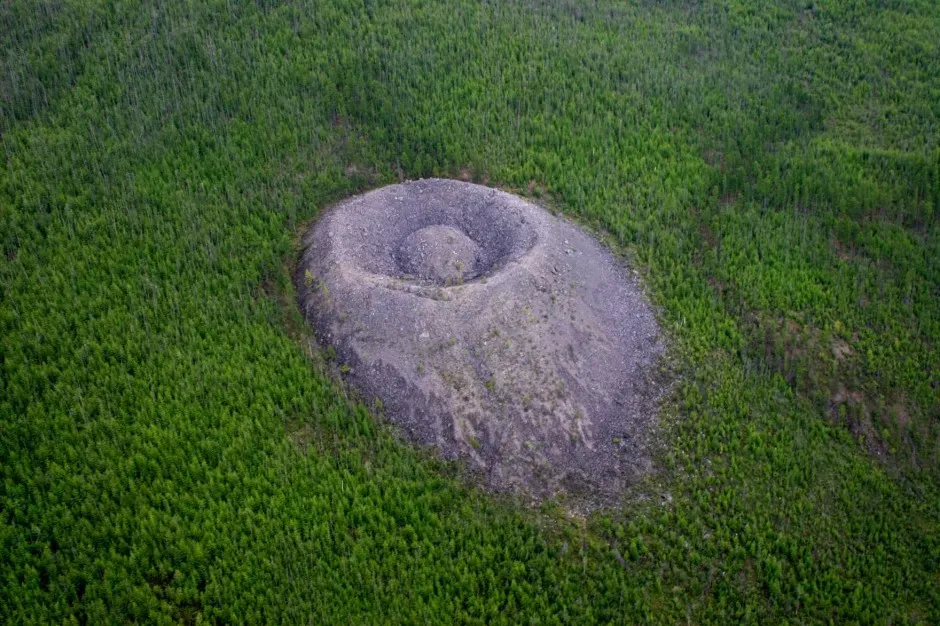
In a remote Siberian forest, the Patomskiy structure rises as a strange stone cone roughly shaped like a volcano, with a central depression and ringed slopes. First documented in the mid-twentieth century, it immediately attracted speculation: impact crater, secret mining operation, even something more outlandish. Geological investigations have ruled out many of the simplest explanations. It does not show the classic shock features of a meteorite impact, nor does it match the chemistry of typical volcanic cones in the region. Yet its shape, size, and position still refuse to line up neatly with known types of landslides, gas explosions, or permafrost features.
Some recent work hints that the structure might be related to deep-seated gas release or slow uplift linked to underlying faults, but the exact mechanism remains contested. The cone seems younger than surrounding terrain, yet not so young that historians would have easily recorded a dramatic event. Tree growth patterns and limited dating efforts suggest a formation timeline that may stretch across centuries rather than a single catastrophe. That sort of slow-motion construction is harder to study and model than an obvious explosion or impact. Until more detailed surveys and drilling campaigns can be carried out in this difficult, remote region, Patomskiy will likely remain one of the most stubborn question marks on the geological map.
Why These Geological Mysteries Matter
It can be tempting to treat these formations as curiosities, good for postcards and social media feeds but not much more. In reality, each mystery points to gaps in our understanding of how Earth’s systems interact across time and scale. When a permafrost crater grows faster than models predict, it hints that we may be underestimating the pace and impact of climate change in vulnerable regions. When rock pillars defy collapse or lakes flow beneath miles of ice in unexpected ways, they highlight the limits of our physical laws as applied to messy, real-world conditions. I’ve sat in conference rooms where seasoned researchers openly admitted that these anomalies keep them awake at night, not because they are supernatural, but because they are stubbornly natural and still unexplained.
These puzzles also serve as stress tests for scientific methods themselves. Geological models work by simplifying reality, but features like the Eye of the Sahara or the sailing stones of Racetrack Playa expose where our simplifications break down. They force collaborations between disciplines – climate scientists working with glaciologists, geomorphologists teaming up with microbiologists, field geologists sharing data with computer modelers. In that sense, mysterious formations are like pressure points in our collective knowledge, revealing which assumptions are solid and which are already starting to crack. Taking them seriously is less about indulging the strange and more about respecting how much complexity the planet still holds.
The Future Landscape: New Tools for Old Rocks
Over the next decade, many of these geological enigmas will be revisited with tools that barely existed when they were first described. High-resolution satellite constellations are already tracking surface changes in remote regions almost in real time, allowing scientists to watch permafrost slumps, subglacial lake drainages, and rockfalls as they happen. Advances in drone-based lidar and ground-penetrating radar will make it easier to map the internal structure of features like Patomskiy or karst towers without intrusive drilling. Tiny, low-power sensors can now sit in hostile environments such as Death Valley’s playa or Antarctic crevasses for months, quietly recording micro-movements and subtle temperature shifts that once went unnoticed. These technologies promise to turn one-off snapshots into detailed time-lapse portraits of how landscapes really behave.
At the same time, machine learning and powerful simulations are beginning to take on some of geology’s messiest pattern-recognition problems. Algorithms can sift through enormous datasets to spot relationships between climate, rock type, and erosion patterns that human experts might miss. Yet there is a catch: these systems are only as good as the data and assumptions fed into them. If our understanding of an under-ice lake system or karst dissolution process is incomplete, the models will simply reproduce our blind spots with greater confidence. The future of decoding Earth’s strangest formations will likely rest on an uneasy partnership between sensors, simulations, and the old-fashioned, boot-on-the-ground work of going to these places, walking on the rock, and letting the questions sink in.
How Curious Readers Can Engage With Earth’s Geological Mysteries
You don’t need a PhD or an expedition grant to play a role in unraveling these puzzles. Many of the most intriguing observations of unusual formations, rock movements, or sinkholes come from hikers, photographers, and local communities who notice when something changes. Citizen science platforms allow people to upload photos, GPS coordinates, and field notes, building time series that researchers can later mine for patterns. Even something as simple as respecting park rules – like staying off delicate playas or not disturbing unusual rock arrangements – helps preserve natural experiments that have taken centuries to set up. In an age of rapid change, careful observation becomes a quiet but powerful form of participation.
If you feel drawn to these mysteries, there are concrete ways to support the work behind the wonder. Donations to field research programs, geological surveys, and polar science initiatives help fund the expensive, unglamorous work of data collection and long-term monitoring. Supporting policies that protect fragile landscapes, from karst systems to permafrost zones, buys scientists time to study them before they are irreversibly altered. And on a personal level, staying curious – asking how that cliff formed, why that valley is shaped just so – keeps the cultural value of Earth science alive. The planet is still writing strange chapters in stone; the real question is whether we are willing to keep reading closely enough to notice.

Suhail Ahmed is a passionate digital professional and nature enthusiast with over 8 years of experience in content strategy, SEO, web development, and digital operations. Alongside his freelance journey, Suhail actively contributes to nature and wildlife platforms like Discover Wildlife, where he channels his curiosity for the planet into engaging, educational storytelling.
With a strong background in managing digital ecosystems — from ecommerce stores and WordPress websites to social media and automation — Suhail merges technical precision with creative insight. His content reflects a rare balance: SEO-friendly yet deeply human, data-informed yet emotionally resonant.
Driven by a love for discovery and storytelling, Suhail believes in using digital platforms to amplify causes that matter — especially those protecting Earth’s biodiversity and inspiring sustainable living. Whether he’s managing online projects or crafting wildlife content, his goal remains the same: to inform, inspire, and leave a positive digital footprint.