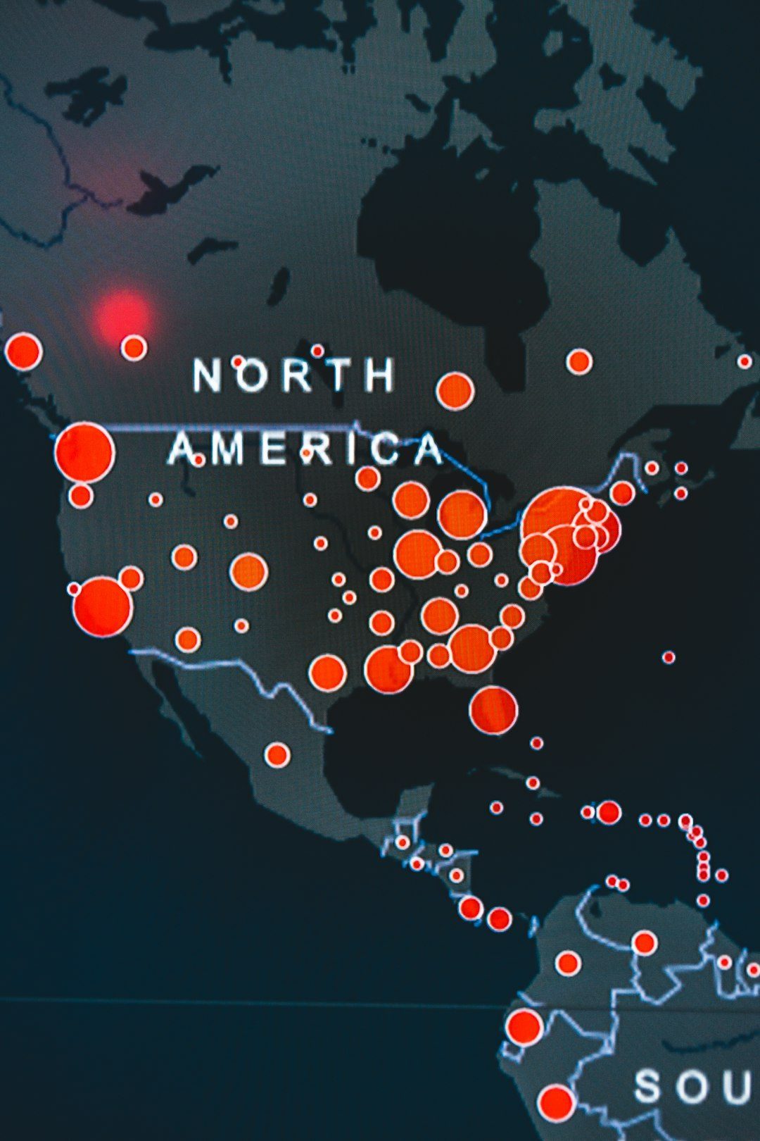
Across the United States, millions of people wake up, commute, and fall asleep above fractures in the Earth’s crust that have unleashed devastating earthquakes in the past – and will do so again. Unlike hurricanes or wildfires, these disasters strike without warning, turning familiar streets into ruptured landscapes in a matter of seconds. Yet in many high-risk cities, skyscrapers still rise, housing booms continue, and infrastructure built for a gentler past strains under a harsher seismic future. Scientists are racing to map hidden faults, refine shaking forecasts, and push for tougher building standards before the next big event hits. The story of these eight cities is a story of how modern America grapples with ancient forces still very much alive beneath its feet.
Los Angeles, California: Living on the edge of the San Andreas
Stand on a clear day in Los Angeles, looking toward the San Gabriel Mountains, and you are staring right at the topographic scars of one of the most famous fault systems on Earth. The greater Los Angeles region is laced not just with the San Andreas Fault to the north and east, but with a tangled web of smaller, dangerous faults such as the Newport–Inglewood, Hollywood, Raymond, and Puente Hills faults. The 1994 Northridge earthquake, which killed dozens of people and caused tens of billions of dollars in damage, came from a previously unrecognized blind thrust fault buried beneath the San Fernando Valley. That disaster was a sobering reminder that the faults we do not see cutting the surface can still pack a deadly punch. Today, detailed mapping, satellite-based ground deformation monitoring, and dense seismometer networks are revealing a complex, shifting puzzle below the city that cannot be ignored.
Scientists now estimate that the southern section of the San Andreas Fault is capable of a magnitude seven or larger earthquake that has not ruptured in roughly three centuries, an unusually long quiet period in geological terms. That locked segment stores strain like a loaded spring, and computer scenarios suggest shaking that could last a minute or more, with severe damage to freeways, pipelines, and older concrete and soft-story buildings. In response, Los Angeles has implemented one of the most aggressive seismic retrofit ordinances in the country, targeting brittle concrete structures and vulnerable apartments with weak ground floors. The city also participates heavily in ShakeAlert, the West Coast’s earthquake early-warning system, which can provide a few seconds of notice before strong shaking arrives. For a region built on cinematic spectacle, the real drama is whether science, engineering, and policy can stay ahead of the next rupture.
San Francisco Bay Area, California: A metropolis in a fault zone maze

In the San Francisco Bay Area, danger does not come from a single fault line but from a small constellation of them, each with its own personality and history. The infamous 1906 San Francisco earthquake ruptured hundreds of kilometers of the San Andreas Fault, but today seismologists are just as concerned about the Hayward Fault running through the densely built East Bay. That fault cuts beneath cities like Oakland, Berkeley, and Hayward, slicing across university campuses, neighborhoods, and even the foundations of homes and sidewalks. Studies have shown that the Hayward Fault has produced a major earthquake roughly every few centuries, and the last big one struck in 1868, when the region was far less populated. Now, the Bay Area’s booming tech economy, crowded freeways, and aging infrastructure sit squarely in the crosshairs of multiple potential ruptures.
Recent mapping shows that the Hayward and Calaveras faults may interact or even link at depth, raising the possibility of multi-fault ruptures that boost earthquake magnitudes beyond what earlier models assumed. Transportation lifelines – the Bay Bridge, BART tunnels, and water and power systems that cross the bay – have undergone major seismic upgrades since the 1989 Loma Prieta earthquake, but vulnerabilities remain, especially in older neighborhoods built on soft bay fill or artificial land. Soft, water-saturated soils can amplify shaking and trigger liquefaction, turning solid ground into a churning slurry that undermines building foundations. Emergency planners run annual drills simulating a large Hayward Fault quake that could displace hundreds of thousands of people and disrupt the region for months. In a place that prides itself on innovation, the Bay Area is learning that adapting to its restless geology is as critical as the next software upgrade.
Seattle, Washington: Between subduction and shallow faults
Seattle’s postcard setting – snowcapped volcanoes, deep blue water, forested islands – sits atop one of the most complex seismic environments in North America. The city is perched above the Cascadia Subduction Zone, where the Juan de Fuca tectonic plate is sliding beneath North America, storing the potential for a massive offshore megathrust earthquake. At the same time, Seattle is crisscrossed by shallow crustal faults, including the Seattle Fault that runs roughly east–west beneath the city and nearby Puget Sound. Geological evidence shows that about a thousand years ago, a major Seattle Fault earthquake uplifted shorelines and generated a local tsunami, permanently reshaping the region. For a modern coastal city with dense downtown high-rises and critical port facilities, that history is deeply unsettling.
Unlike California’s transform faults, subduction zone earthquakes can reach magnitudes in the high eights or even larger, triggering long-lasting shaking and widespread regional impacts. That is the nightmare scenario for Cascadia, where offshore sediments and buried evidence point to a line of great earthquakes occurring roughly every few centuries, the most recent one in the early eighteenth century. In Seattle itself, a shallower Seattle Fault rupture could produce stronger, more abrupt shaking, particularly hazardous for unreinforced masonry structures still common in older neighborhoods. Urban planners are now incorporating tsunami evacuation routes, stricter building codes, and retrofits for schools, hospitals, and bridges into long-term city plans. For residents sipping coffee in waterfront cafes, the biggest threats are quiet, slow-building, and literally beneath the surface of their daily routines.
Memphis, Tennessee: A quiet city above a restless past
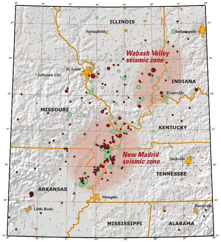
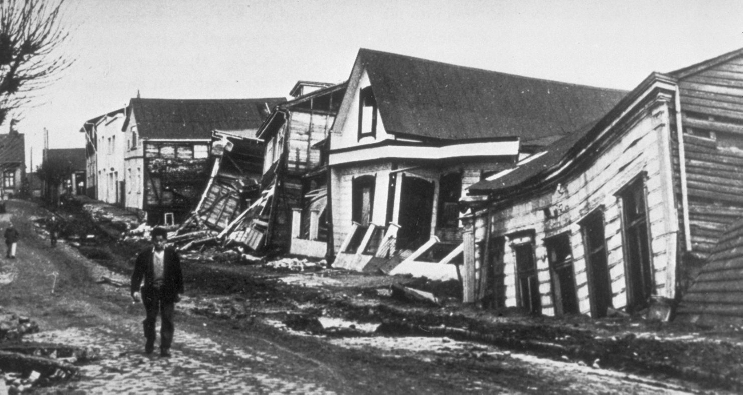
Memphis is better known for blues music and barbecue than for earthquakes, but its geological setting tells a more unsettling story. The city lies near the New Madrid Seismic Zone, a series of faults in the central Mississippi Valley that unleashed a remarkable swarm of huge earthquakes in the winter of 1811–1812. Those events were powerful enough to ring church bells on the East Coast, cause landslides along river bluffs, and reportedly make the Mississippi River briefly run backward in places. At the time, the region was sparsely populated, and there were no high-rises, interstates, or modern levees to test against that level of shaking. Today, Memphis and the surrounding area are home to major freight hubs, pipelines, bridges, and millions of residents who would experience those same forces very differently.
Central and eastern North America transmit seismic waves more efficiently through older, colder crust than the fractured, hot rocks of the West Coast. That means a moderate to large quake in the New Madrid region could be felt over an enormous area, impacting cities hundreds of kilometers away and stressing buildings never designed with earthquakes in mind. Many structures in Memphis are older masonry buildings that can crumble under lateral shaking, and critical lifelines – rail yards, interstate corridors, and river crossings – converge along vulnerable soils and riverbanks. Hazard maps have been updated repeatedly as scientists refine models of how strain accumulates and releases on these buried faults, leading to continued debate about the exact probabilities but little doubt about the potential consequences. For a city that sees itself as safely inland, accepting that it sits in a seismic bullseye is still an ongoing challenge.
St. Louis, Missouri: Heartland metropolis in the New Madrid shadow
Several hours upriver from Memphis, St. Louis may seem even more distant from classic earthquake country, yet it shares the same underlying risk from the New Madrid Seismic Zone. The city’s iconic Gateway Arch, historic riverfront warehouses, dense brick neighborhoods, and sprawling suburbs sit on and near river sediments that could amplify shaking from a distant but powerful quake. Unlike on the West Coast, where earthquakes are part of popular culture and public drills are routine, many Midwestern residents rarely think about seismic safety beyond a passing headline. That cultural blind spot means that older, brittle buildings, schools, and churches remain unretrofitted, and emergency plans sometimes prioritize floods and tornadoes while giving earthquakes less attention. At the same time, the city’s role as a logistics and industrial hub could make recovery from a major quake both nationally significant and painfully complicated.
Geologists continue to search for clearer signals in the deep subsurface, using seismic reflection, GPS, and satellite measurements to detect how the crust is deforming. The lack of frequent large quakes in the modern instrumental record makes forecasting more uncertain, but paleoseismic evidence from sand blows and deformed sediments confirms that the region has seen repeated seismic episodes in the last several thousand years. Infrastructure like bridges over the Mississippi and Missouri rivers, older highway interchanges, and buried pipelines are being assessed for seismic resilience, but progress often depends on limited funding and political will. Insurance uptake for earthquake coverage in the region is relatively low, leaving many homeowners financially exposed. St. Louis, like much of the central United States, is still deciding how seriously to take the quiet warnings written into its landscape.
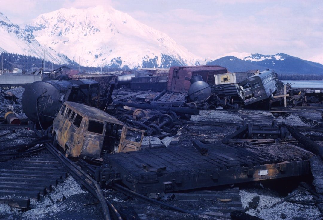
Anchorage, Alaska: Remembering North America’s giant
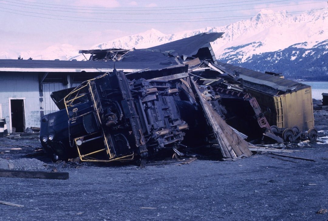
Anchorage sits in one of the most seismically active belts on the planet, on the front line of the Pacific Ring of Fire, where the Pacific Plate dives beneath Alaska along a powerful subduction zone. In 1964, a colossal magnitude nine earthquake ruptured a long section of that fault, shaking for several minutes and triggering landslides, ground failures, and tsunamis that devastated parts of coastal Alaska. Anchorage itself suffered collapsed neighborhoods where soft ground slumped and slid, and the memory of that event still shapes the city’s identity and engineering culture. Since then, seismometers have recorded countless smaller quakes, some strong enough to damage buildings and rattle nerves even in recent years. For residents, living with regular shaking is simply part of life, but the prospect of another giant rupture always looms in the background.
Detailed monitoring has turned Alaska into a natural laboratory for understanding subduction processes, slow-slip events, and how megathrust earthquakes nucleate and propagate. Civil engineers in Anchorage design to much more stringent seismic standards than many lower forty-eight cities, integrating lessons from both the 1964 quake and subsequent events. Still, steep slopes, thawing permafrost, and coastal bluffs present ongoing hazards when shaking strikes, as gravity and unstable soils conspire to amplify damage. Critical infrastructure – from the port and airport to pipelines and communication cables – has been strengthened, but the vast distances and harsh climate make rapid repair difficult. In Anchorage, the question is not whether the ground will move again, but how prepared the city will be when the next truly historic rupture arrives.
Salt Lake City, Utah: A growing city on a waking fault
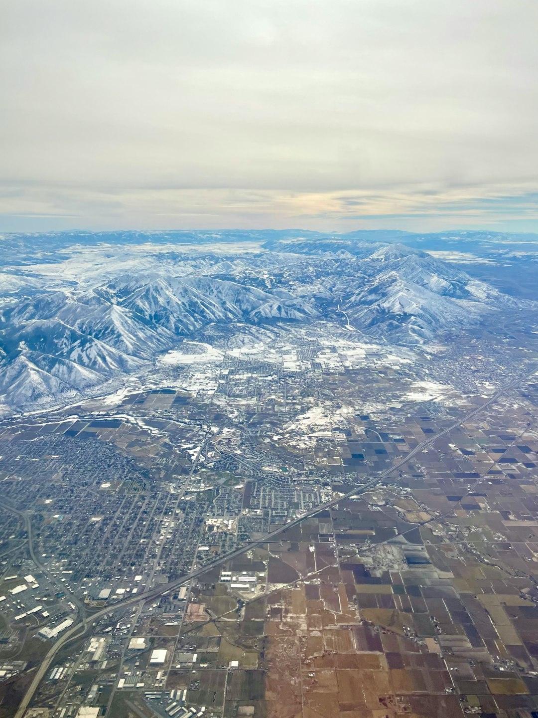
Salt Lake City has exploded in population and development in recent decades, with new apartment towers, tech campuses, and subdivisions marching across the valley. All of that growth hugs the base of the Wasatch Range, where the Wasatch Fault forms a dramatic, steep front between mountains and basin. Geological trenching along this fault reveals a history of repeated large earthquakes over the last several thousand years, each one stepping the mountains higher and dropping the valley floor. Many of those prehistoric events reached magnitudes in the high sixes or low sevens, big enough to produce widespread damage in a modern urban corridor. The last major surface-rupturing quake on the central Wasatch segment occurred several centuries ago, which may sound comforting but actually suggests the clock is ticking toward another.
Salt Lake City’s particular vulnerability lies in its combination of vulnerable building stock and tricky soils. Wide swaths of the valley sit on lakebed sediments from ancient Lake Bonneville, which can strongly amplify seismic waves, increasing shaking intensity for structures sitting atop them. A recent moderate earthquake in 2020, while not catastrophic, cracked buildings, damaged the iconic Mormon Temple’s spire, and served as a sharp wake-up call for many residents. Engineers and planners are now pushing harder for retrofits of unreinforced masonry buildings and for stricter design standards in schools and hospitals. As the region continues to market itself as a thriving tech and outdoor recreation destination, it is being forced to reckon with the fault that made its scenery possible in the first place.
Why it matters: Rethinking which cities are truly “safe”
These eight cities illustrate a broader truth that challenges a lot of casual assumptions about American geography and safety. Earthquake risk is not confined to the West Coast, and it is not simply a matter of whether a city lies near a single famous fault line. Instead, risk emerges from a mix of geology, building practices, infrastructure age, population density, and community awareness. A moderate quake beneath an older Midwestern city with brittle buildings can be just as devastating, or worse, than a larger but better-planned event in California. Thinking only in terms of magnitude without considering soil conditions, construction standards, and emergency preparedness gives a dangerously incomplete picture.
Traditional hazard maps once painted a fairly simple picture: bright colors along the Pacific margin, cooler tones inland. Modern science has complicated that view, revealing buried fault systems, long-lived intraplate zones like New Madrid, and local effects that can make certain neighborhoods hot spots within otherwise moderate regions. This matters for how we design homes, schools, hospitals, and lifelines such as water, power, and data networks that tie the country together. It also raises uncomfortable questions about equity when lower-income communities, often living in older housing and weaker soils, shoulder a disproportionate share of the risk. Ultimately, understanding fault lines beneath American cities is less about chasing scientific curiosity and more about deciding what level of avoidable tragedy we are willing to tolerate.
The future landscape: Better forecasts, tougher buildings, and hard choices
Looking ahead, the science of earthquake hazard is shifting from static maps to dynamic, data-rich forecasts that can be updated as new information comes in. Satellite radar can now detect millimeter-scale shifts in the ground over wide areas, helping scientists track how strain accumulates on faults bracketing cities like Los Angeles, Seattle, and Salt Lake City. Dense seismic arrays and machine learning techniques are improving our ability to distinguish tiny signals from noise, revealing previously hidden faults and subtle slow-slip events deep underground. At the same time, early-warning systems are slowly expanding, offering those precious seconds of advance notice that can halt trains, open firehouse doors, and prompt people to drop, cover, and hold on. These advances do not stop earthquakes, but they can transform them from total surprises into hazards we can at least partially brace for.
On the engineering and policy side, future resilience hinges on building codes, retrofits, and land-use decisions that take fault lines seriously. Some cities are considering fault-avoidance zones where new critical facilities such as hospitals, emergency operation centers, and data hubs cannot be built directly atop active faults. Others are weighing how to handle aging high-rises or clusters of brittle buildings that could become mass-casualty sites in a major quake. Choices about where to allow dense development, how to price insurance, and whether to subsidize upgrades in lower-income neighborhoods will shape who suffers most when the ground moves. As climate change reshapes where people live due to fires, floods, and heat, some regions at high seismic risk may even see population inflows, putting more lives and assets atop already dangerous ground.
What you can do: Turning awareness into action
For most people living in these cities, the idea of moving away from fault lines is neither realistic nor even desirable; their families, jobs, and communities are tied to these places. What is possible, though, is to turn abstract seismic risk into concrete steps that reduce the chances of disaster. Individuals can start by learning their local fault zones and soil conditions, checking whether their homes or workplaces are built to modern seismic standards, and asking landlords or employers direct questions about safety and retrofits. Simple preparedness measures – a secured water heater, fastened bookshelves, an emergency kit with food, water, and medications – can make a real difference when shaking hits. Community-level actions, like supporting stronger building codes and funding for retrofitting schools and hospitals, can quietly save hundreds or thousands of lives down the line.
Paying attention to earthquake drills, signing up for local alert systems, and taking part in regional preparedness campaigns helps normalize the idea that earthquakes are not freak events but part of life in many parts of the country. If you live in one of these eight cities – or in any region with seismic potential – talking with neighbors, joining local preparedness groups, or supporting science-based planning efforts are simple but powerful contributions. Ultimately, fault lines do not negotiate, but societies do, and we get to choose how seriously we take the stories written in our landscapes. The ground beneath American cities will keep shifting on geological timescales; our challenge is to move faster in how we plan, build, and prepare. Did you expect so many “unexpected” earthquake cities to be on the list?

Suhail Ahmed is a passionate digital professional and nature enthusiast with over 8 years of experience in content strategy, SEO, web development, and digital operations. Alongside his freelance journey, Suhail actively contributes to nature and wildlife platforms like Discover Wildlife, where he channels his curiosity for the planet into engaging, educational storytelling.
With a strong background in managing digital ecosystems — from ecommerce stores and WordPress websites to social media and automation — Suhail merges technical precision with creative insight. His content reflects a rare balance: SEO-friendly yet deeply human, data-informed yet emotionally resonant.
Driven by a love for discovery and storytelling, Suhail believes in using digital platforms to amplify causes that matter — especially those protecting Earth’s biodiversity and inspiring sustainable living. Whether he’s managing online projects or crafting wildlife content, his goal remains the same: to inform, inspire, and leave a positive digital footprint.