Weather is supposed to be predictable, at least in theory: satellites watch every cloud, supercomputers crunch equations, and forecast models get updated almost by the minute. Yet, scattered across the sky and around the globe are phenomena that refuse to fit neatly into the equations, leaving even veteran atmospheric scientists muttering that they still do not fully understand what they are seeing. Some of these events look almost supernatural, the kind of thing people once blamed on angry gods or omens in the heavens. Others are so subtle that they are visible only with ultra-sensitive instruments but may hint at forces we are barely beginning to measure. As our climate warms and extremes intensify, these mysterious events are no longer just curiosities; they are clues that something deeper is still missing in our understanding of Earth’s atmosphere.
Morning Glory Clouds: The Sky’s Rolling Enigma

Imagine waking up at dawn and seeing a perfect, low, tubular cloud stretching from horizon to horizon, rolling silently across the sky like a gigantic atmospheric wave. That is the Morning Glory, a rare cloud formation most famously seen over the Gulf of Carpentaria in northern Australia, where locals treat its arrival almost like the return of a migrating animal. Pilots who glide along its length describe a ride that feels more like surfing an invisible wave than flying through air, with powerful updrafts and downdrafts packed into a relatively thin layer of atmosphere. What baffles scientists is not just how dramatic it looks, but why it forms so reliably in some seasons over this particular region while remaining almost impossible to predict elsewhere. The basic idea involves a kind of atmospheric “solitary wave” triggered by sea breezes, temperature contrasts, and coastal geometry, yet models still struggle to capture the exact combination that makes it all click into place.
In many ways, the Morning Glory is a stress test for our weather models: if we cannot reliably predict such a well-defined feature, what else are we missing in more chaotic situations like severe storms. Researchers have tried to recreate these waves in high-resolution simulations and wind-tunnel analogs, but even the best efforts often end up too simplified compared to real-world complexity. Local Indigenous communities had watched these clouds for generations long before meteorologists arrived with instruments, and pilots now trade stories about “chasing” the Morning Glory as if it were a living thing. That mix of tradition, human experience, and cutting-edge science gives this cloud an almost mythic status, a reminder that even a simple-looking stripe in the sky can hide staggeringly complicated physics. The unsettling part is that while we understand pieces of the puzzle, the full picture still keeps rolling just ahead of us, quite literally over the horizon.
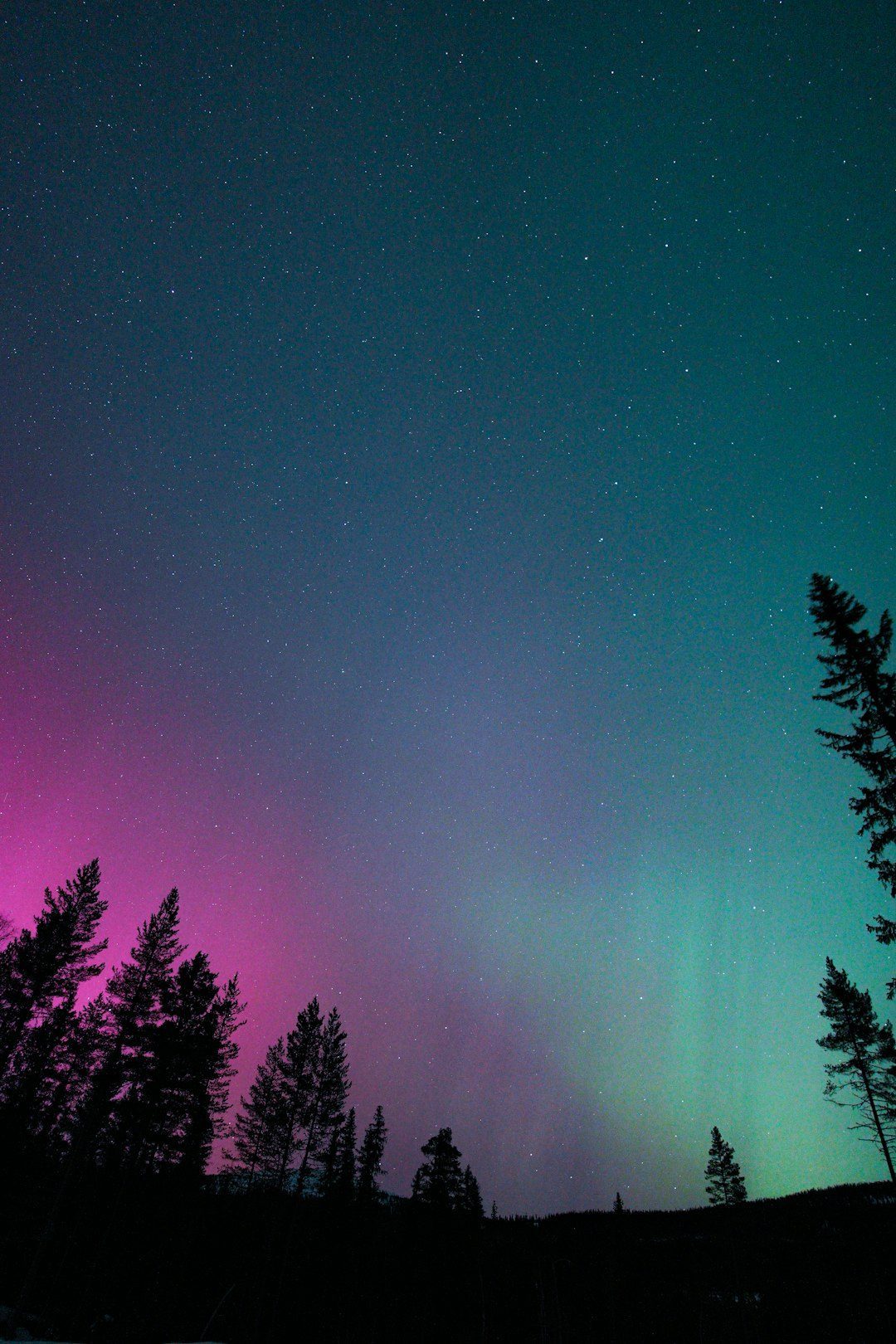
Sprites, Blue Jets, and Elves: Ghostly Lightning Above the Storms
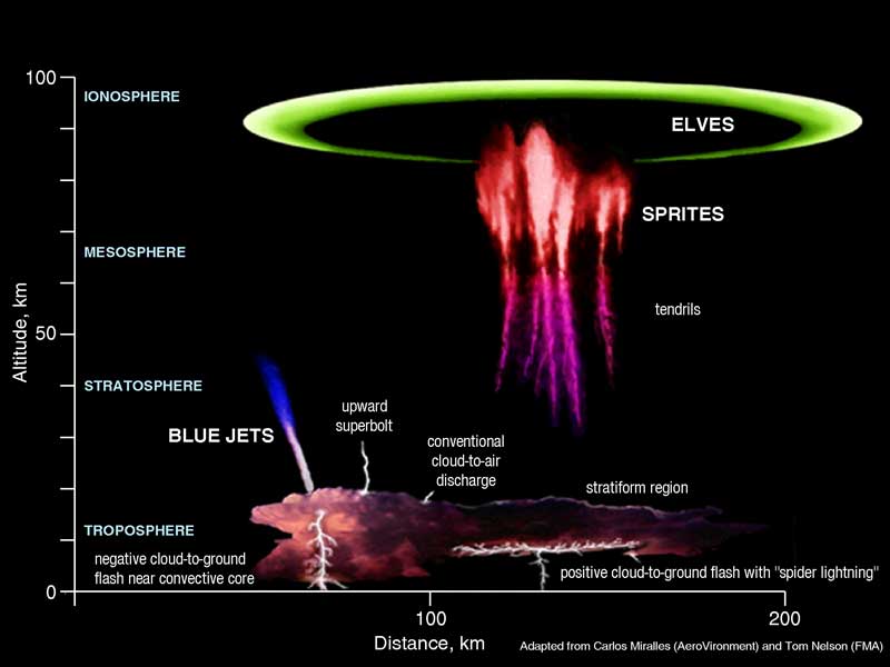
High above thunderstorms, where the air should be calm and thin, strange flashes of crimson, blue, and ultraviolet light flicker for mere milliseconds, often invisible to the naked eye. These are transient luminous events – sprites, blue jets, elves, and more – and they were dismissed as pilot hallucinations or camera glitches until better sensors finally proved they were real. Sprites look like upside-down jellyfish or ghostly red trees reaching down from the edge of space, while blue jets shoot upward from thundercloud tops like luminous spears. What makes them so mysterious is that they occur well above the main lightning channels, in a region of the atmosphere that is not supposed to host such dramatic electrical fireworks. Even today, scientists are still working out the exact electrical pathways that lead from a bolt of lightning in a storm to a sprite more than 30 miles above.
These events are not just pretty sky shows; they might be tinkering with the chemistry of the upper atmosphere in ways we do not fully understand. They can generate brief bursts of high-energy radiation and may influence the balance of nitrogen oxides and ozone at altitudes where climate and space weather intersect. Researchers now use high-speed cameras, satellites, and even cameras on the International Space Station to capture them, but they still struggle to predict when and where they will appear. Some studies suggest they might serve as a kind of pressure-release valve for enormous electric fields that build up above storms, but those explanations are still being tested. There is something quietly unsettling about the idea that, even in one of the most studied natural processes – lightning – we are still discovering whole families of phenomena hiding in the thin air above our heads.
Ball Lightning: The Elusive Fire Orb No One Can Agree On

Ball lightning is the kind of phenomenon that splits a room of scientists into skeptics and believers within minutes, yet the number of credible eyewitness accounts is hard to ignore. People describe glowing, floating spheres of light – sometimes small, sometimes larger than a basketball – drifting through the air during thunderstorms, occasionally passing through windows, doors, or even airplane cabins before vanishing with a pop or a quiet fade. For decades, many researchers suspected people were simply misinterpreting afterimages or conventional lightning reflections, but video evidence and carefully documented reports have pushed the conversation away from outright dismissal. The trouble is that ball lightning refuses to behave like any ordinary electrical discharge, and laboratory recreations tend to be partial, short-lived, or dependent on very contrived conditions. Even the basic question of what a ball lightning orb is made of – plasma, vaporized materials, trapped microwaves, or something else – remains an open debate.
Several proposed theories are almost cinematic in their creativity: one suggests that intense lightning strikes vaporize soil or metal into a glowing, self-sustaining cloud, while another imagines electromagnetic waves trapped in a kind of atmospheric bubble. None of these ideas has yet risen to the level of a widely accepted explanation that fits both physics and the messy details of real-world sightings. Unlike ordinary lightning, which follows clear statistical patterns, ball lightning reports are scattered, brief, and unpredictable, making systematic study notoriously difficult. A few lucky high-speed measurements have captured ball-like glows near transmission lines and storm sites, but even those data are sparse and open to interpretation. In an age when many people assume every natural phenomenon has already been neatly categorized, ball lightning sits stubbornly at the boundary between folklore and physics, taunting researchers every time a new incident makes the news.
Hailstorms That Explode Beyond Models
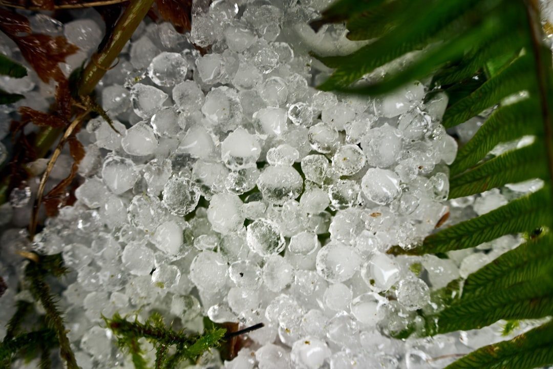
Hail is familiar enough in many places, but every so often a storm drops ice that seems almost absurd in scale, with individual stones larger than grapefruits slamming into the ground. These extreme hailstorms can shred crops in minutes, punch holes in roofs and aircraft, and generate damage totals that rival small hurricanes. We know that hail forms in strong updrafts that repeatedly loft droplets through freezing layers inside a storm, building up layers of ice like an onion before gravity finally wins. Yet when hail stones reach extraordinary sizes, the physics becomes genuinely puzzling, because the updrafts needed to hold them aloft strain the limits of what models say is possible. There have been verified reports of stones weighing more than a pound, raising uncomfortable questions about whether our understanding of storm structure, microphysics, and turbulence is incomplete.
Hailstorms also seem to be shifting in behavior as the climate warms, with some research hinting that the most intense events may be becoming more frequent or occurring in new regions, though the trends are not yet fully clear. That uncertainty makes them particularly unnerving for farmers, insurers, and city planners, who have to design buildings and protections based on best guesses about future extremes. Radar and satellite tools have improved hail detection from space, but forecasters still struggle to distinguish between a storm that will drop small, nuisance hail and one that will unleash potentially lethal ice bombs. Each extreme event effectively becomes a field experiment, producing data that modelers then try to weave into better simulations, though the gaps remain noticeable. As someone who has watched a supposedly “routine” thunderstorm suddenly turn into a hail-shredding monster over a neighborhood, I find it hard not to think of these storms as the atmosphere’s way of revealing where our science is still thin.
Atmospheric Rivers: Hidden Sky Rivers That Flood Without Warning
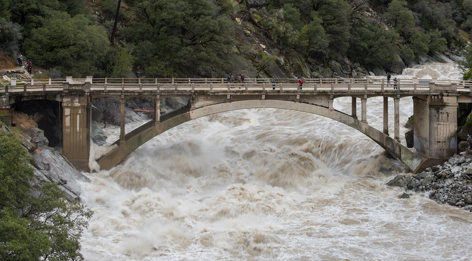
Far above the ocean, long, narrow bands of moisture can stretch for thousands of miles, carrying more water vapor than many of the world’s largest rivers. These atmospheric rivers, as scientists call them, can slam into coastlines and unleash days of intense rain and snow, sometimes turning a calm winter week into a catastrophic flood. They are crucial for delivering water to mountain snowpacks and reservoirs, but they also drive some of the most destructive floods on record, especially along the west coasts of continents. The mystery is not whether they exist – that part is well documented – but why some atmospheric rivers release their moisture in manageable doses while others dump it in devastating torrents. Small shifts in ocean temperature, wind patterns, and planetary waves seem to make an outsized difference, yet those triggers are difficult to predict more than a week or so in advance.
For communities living in the crosshairs, this uncertainty is more than a scientific curiosity; it is a direct risk to lives and infrastructure. Traditional weather forecasts can warn that heavy rain is coming, but they often underestimate the intensity or duration when an atmospheric river stalls or gets reinforced by other systems. Some climate models suggest that as global temperatures rise, these sky rivers may carry more water and reach farther inland, increasing the odds of extreme events even in places that did not historically see them as often. That possibility has emergency managers scrambling to rethink flood defenses, early-warning systems, and reservoir rules to accommodate rare but devastating bursts. It is a surreal thought that invisible rivers of air above us may decide, with little warning, whether a winter becomes a blessing of water or a billion-dollar disaster.
Snowstorms from Clear Skies: The Puzzle of Lake-Effect and Sea-Effect Bursts
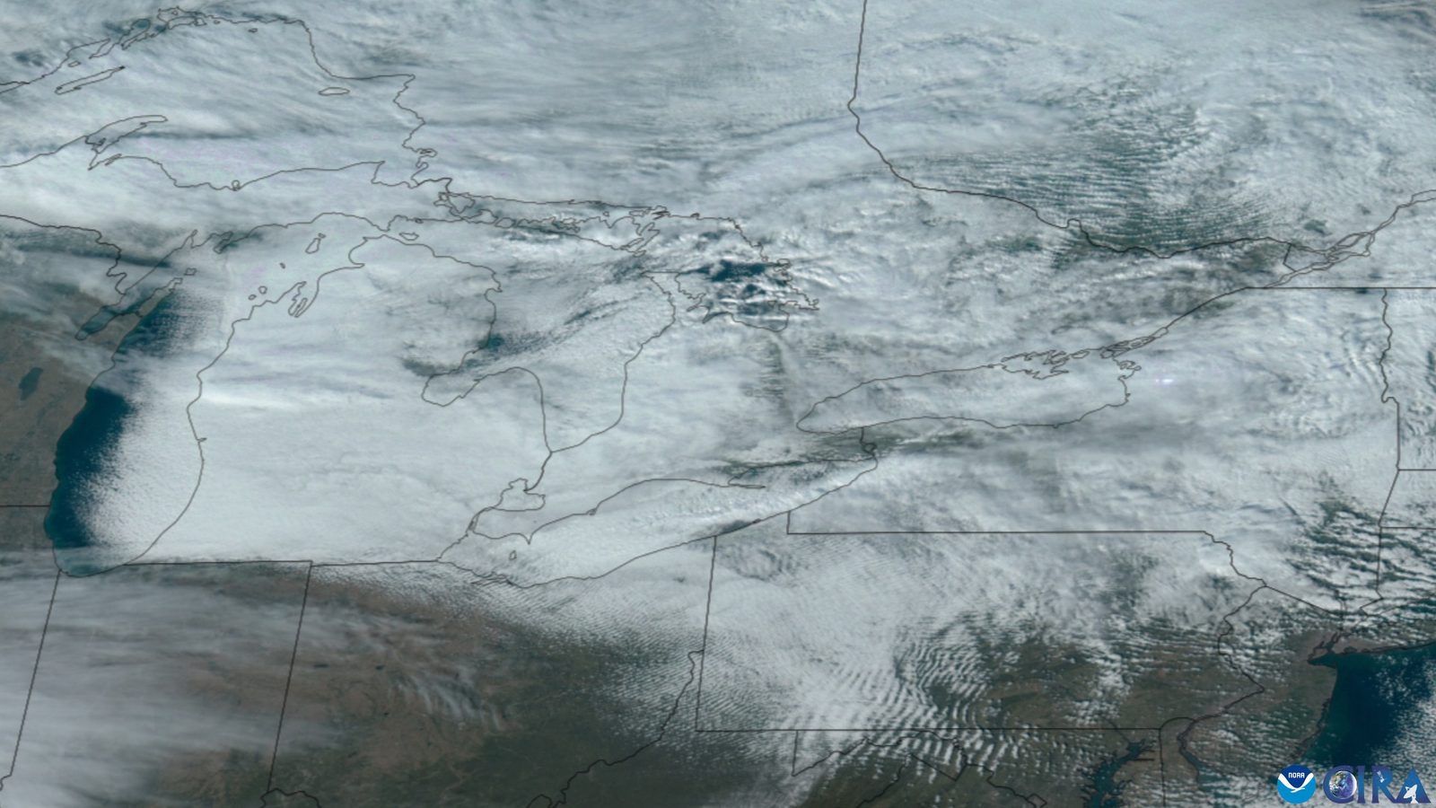
In certain regions, people wake up to feet of snow despite weather maps that showed mostly calm conditions only hours before, a pattern often blamed on lake-effect or sea-effect snow. When cold, dry air passes over relatively warm water, it can pick up huge amounts of moisture and then dump it as intense, narrow bands of snow just downwind of the shoreline. That basic mechanism is well known, but what remains mysterious is how these snow bands organize themselves into such sharp, localized structures, sometimes dumping astonishing amounts of snow on one town while leaving another, only a few miles away, almost untouched. Residents often describe it as standing at the edge of a snow curtain, with one side in a blizzard and the other under bright blue sky. Forecast models, even at high resolution, still struggle to track exactly where these bands will set up and how long they will persist.
These snow bursts create real-world challenges that go far beyond atmospheric curiosity. Municipal crews trying to plan plowing routes, school districts deciding on closures, and emergency services preparing for road accidents all rely on precise forecasts that the science still cannot reliably deliver in every case. Climate change complicates the picture further, because warming lakes and seas can initially enhance these bursts, while long-term shifts might eventually reduce them as ice cover and temperature gradients change. That means communities built around historical snow patterns may find those patterns reshuffling in confusing and disruptive ways. Standing under one of these bands, with snow piling up several inches an hour while the horizon glows clear just beyond it, you get a visceral sense of how complex and finely balanced local weather can be.
Why These Mysteries Matter for the Rest of Us
It is tempting to treat Morning Glory clouds, sprites, ball lightning, and ultra-local snow bands as charming quirks of nature, the atmospheric equivalent of party tricks. But each one points to a gap in how we represent the atmosphere in the models that guide everything from aviation routes to flood insurance to climate policy. Traditional meteorology has focused on large-scale patterns – jet streams, pressure systems, seasonal averages – while many of these mysteries involve small-scale structures, rapid flashes, or rare extremes that are easy to gloss over. When these weird events interact with human systems, the consequences can be severe: missed warnings for flooding from an atmospheric river, underestimated hail damage in growing suburbs, or aviation hazards from poorly understood electrical phenomena above storms. They reveal that the old assumption that we “basically know how weather works” is more fragile than most people realize.
In a sense, these phenomena are like stress fractures in a bridge: they may seem minor at first glance, but they hint at weaknesses that could matter under heavier loads. As climate change increases the energy and moisture available to storms, the strange corners of atmospheric behavior are more likely to play a starring role instead of staying on the margins. Comparing today’s unresolved questions with those from a few decades ago also shows how slow and painstaking progress can be, especially when data are rare or difficult to capture. That should be a humbling reminder that our atmospheric knowledge is still a work in progress, and that the stories we tell about “once in a lifetime” events may need constant revision. Even if you never see a Morning Glory or a ball lightning orb yourself, the science built around those mysteries quietly shapes the forecasts and risk assessments that affect your daily life.
The Future Forecast: New Eyes, Better Models, and Bigger Questions

Looking ahead, the tools being developed to study these mysterious weather phenomena are as fascinating as the events themselves. Constellations of small satellites, high-altitude balloons, and even citizen-science camera networks are giving researchers more chances to catch sprites, blue jets, and rare storm structures in the act. Machine-learning systems are being trained to mine radar and satellite data for subtle signatures that might hint at when a severe hail core is about to explode beyond expectations or when an atmospheric river is poised to stall over a vulnerable valley. At the same time, ultra-high-resolution climate models are starting to simulate features once considered too small or fleeting to include, potentially revealing connections between rare events and larger climate shifts. None of this guarantees quick answers, but it does mean that the next decade could transform some of today’s mysteries into tomorrow’s textbook case studies.
There are also big, uncomfortable questions that this new technology will force us to confront. If we discover that extreme hail or atmospheric rivers are becoming more intense in a warming world, how fast can societies realistically adapt their infrastructure, insurance systems, and emergency planning. What happens if new data reveal previously unrecognized risks to aviation or power grids from upper-atmosphere electrical phenomena. International collaboration will be crucial, because many of these phenomena span continents and oceans, ignoring political boundaries entirely. In that sense, the future of mysterious weather research is not just about better gadgets, but about building trust, sharing data, and accepting that the atmosphere still has surprises in store for us.
How You Can Engage with the Mysteries Above

Most of us will never operate a research aircraft or launch a weather satellite, but that does not mean we are shut out from this unfolding story in the sky. Simply paying closer attention to unusual clouds, strange lightning, or sudden hyper-local snow can turn you into a valuable observer, especially if you document what you see with time-stamped photos or short descriptions. Many meteorological agencies and research groups now welcome public reports of rare events, because those scattered observations help scientists narrow down where to look with more specialized instruments. If you live in a region prone to intense storms, hail, or atmospheric rivers, basic preparedness – updated emergency kits, awareness of local alert systems, and conversations with neighbors – can turn mysterious weather from a terrifying surprise into a manageable, if still awe-inspiring, challenge.
There are also quieter ways to support this kind of science, from backing public research institutions to engaging with local climate and weather literacy programs. When policymakers hear that voters actually care about better forecasting systems, infrastructure upgrades, and open data, it becomes easier to fund the instruments and field campaigns that push knowledge forward. Even small personal choices, like being mindful of contributions to climate change, tie into the bigger picture, because a more energized atmosphere amplifies many of these mysterious extremes. The next time an unusual cloud, sudden burst of hail, or eerie flicker of lightning catches your eye, consider it an invitation to stay curious and stay informed. After all, the sky is not just a backdrop – it is an active, evolving system that we are still learning to read.

Suhail Ahmed is a passionate digital professional and nature enthusiast with over 8 years of experience in content strategy, SEO, web development, and digital operations. Alongside his freelance journey, Suhail actively contributes to nature and wildlife platforms like Discover Wildlife, where he channels his curiosity for the planet into engaging, educational storytelling.
With a strong background in managing digital ecosystems — from ecommerce stores and WordPress websites to social media and automation — Suhail merges technical precision with creative insight. His content reflects a rare balance: SEO-friendly yet deeply human, data-informed yet emotionally resonant.
Driven by a love for discovery and storytelling, Suhail believes in using digital platforms to amplify causes that matter — especially those protecting Earth’s biodiversity and inspiring sustainable living. Whether he’s managing online projects or crafting wildlife content, his goal remains the same: to inform, inspire, and leave a positive digital footprint.