Most Americans picture California or Alaska when earthquakes come to mind, but there’s a seismic time bomb ticking right in America’s heartland. You drive through Missouri, Arkansas, Tennessee, Kentucky, and Illinois every day, never knowing that beneath your feet lies one of the most dangerous fault systems in the entire country.
The truth might shock you more than the ground itself could. While everyone focuses on the San Andreas Fault, scientists have been quietly watching a zone that could unleash devastation across a region home to millions of people. The soil here amplifies earthquake waves like a giant speaker system, spreading destruction far beyond what California typically experiences.
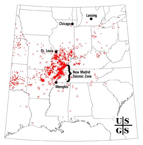
The New Madrid Mystery Zone
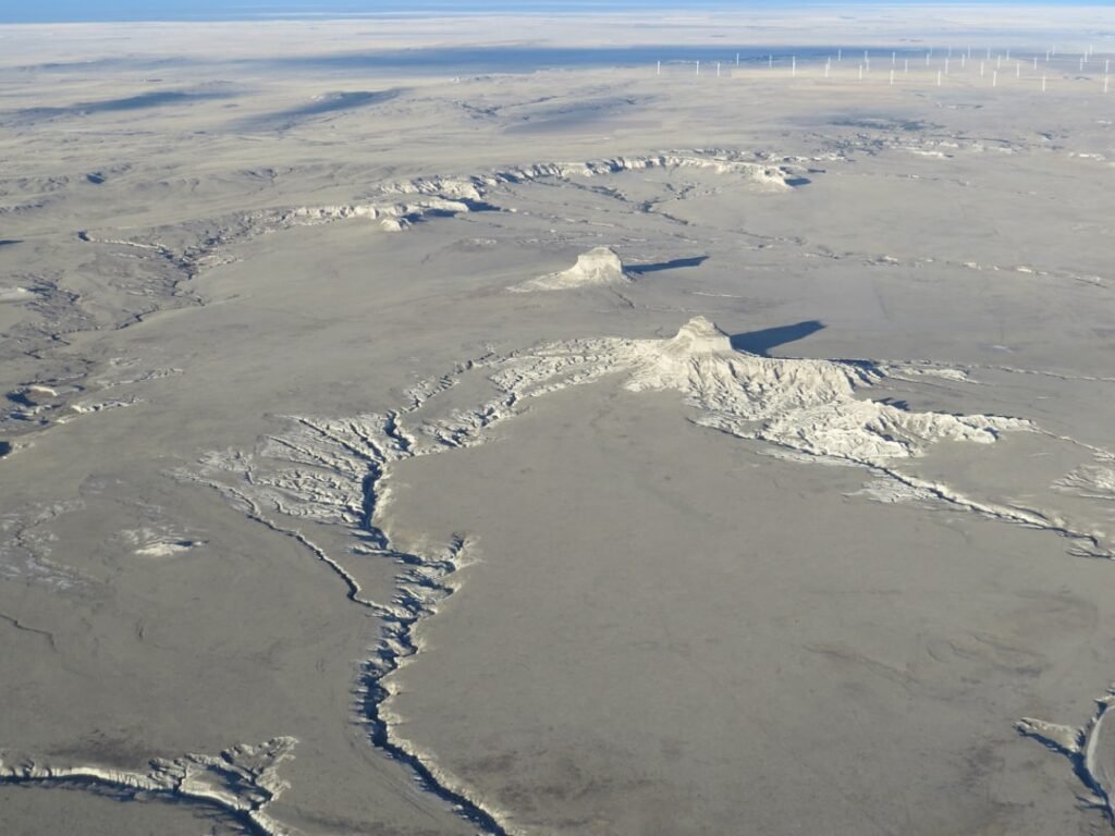
The New Madrid Seismic Zone, located in southeastern Missouri, northeastern Arkansas, western Tennessee, western Kentucky and southern Illinois, is the most active seismic area in the United States, east of the Rocky Mountains. Since 1974, seismometers have recorded thousands of small to moderate earthquakes, though the faults that produce earthquakes are not easy to see at the surface because they are eroded by river processes and deeply buried by river sediment.
This hidden nature makes the zone particularly dangerous because the faults are buried beneath 100- to 200-foot thick layers of soft river sediments called alluvium, and surface traces of the faults in the soft alluvium erode quickly or may be rapidly covered by new deposits thereby hiding evidence of earlier earthquakes locations. You’re essentially living above a geological secret that refuses to reveal its full extent.
There is broad agreement in the scientific community that a continuing concern exists for a major destructive earthquake in the New Madrid seismic zone. The U.S. Geological Survey predicts that there’s a 25% to 40% chance of a 6.0-magnitude earthquake along the seismic zone within the next 50 years.
When the Earth Cracked America in Half
In the winter of 1811 and 1812, the New Madrid seismic zone generated a sequence of earthquakes that lasted for several months and included three very large earthquakes estimated to be between magnitude 7 and 8, destroying several settlements along the Mississippi River and causing minor structural damage as far away as Cincinnati, Ohio, and St. Louis, Missouri. One such uplift related to faulting near New Madrid, Missouri, temporarily forced the Mississippi River to flow backwards.
Approximately 5,500 square miles or about 3.5 million acres of the Mississippi and Ohio river valleys were impacted by landslides, fissures, sandblows, lateral spreads, subsidence, submergence and uplift, with the basic single story log buildings often shifting or sinking as parts of the areas submerged and flooded. The earthquake literally rewrote the landscape of the American heartland.
Witnesses described something that sounds more like a horror movie than reality. Witnesses at the time reported seeing “waves” in the soil as the earth moved, and because of the delta alluvial soil here, earthquake energy is more apt to travel much farther than those in the rocky California area.
The Sleeping Giants Next Door
Two seismic zones contribute to the earthquake hazard in Missouri; the New Madrid Seismic Zone and the Wabash Valley Seismic Zone. “I think everyone’s interested in the Wabash Valley Fault because a lot of the attention has been on the New Madrid Fault, but the Wabash Valley Fault could be the more dangerous one, at least for St. Louis and Illinois. The strongest earthquakes in the last few years have come from the Wabash Valley Fault, which needs more investigation.”
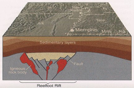
Current assessments indicate several major faults including the Reelfoot Rift in the Missouri bootheel and western Kentucky area, one in the Wabash valley region, and one in southern Illinois known as the Commerce Lineament, with each of these areas having the potential to produce large earthquakes. You’re surrounded by multiple fault systems that most people have never heard of.
Scientists know that the Wabash Valley seismic zone has magnitude 6.5 or greater earthquakes with about a 4,000-year recurrence. This makes the zone a ticking time bomb with a frighteningly predictable schedule.
Why Midwest Earthquakes Hit Differently
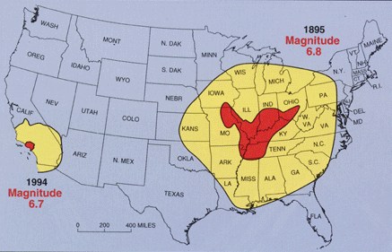
Due to the nature of the bedrock in the earth’s crust in the central United States, earthquakes in this region can shake an area approximately 20 times larger than earthquakes in California. The geology here acts like a massive amplifier, turning moderate earthquakes into regional catastrophes.
Since the Central United States geology is susceptible to soil liquefaction, earthquake damage is magnified over a potentially wider area, with the greatest earthquake risk east of the Rocky Mountains along the NMSZ, where damaging earthquakes cover more than 15 times the area because of the underlying geology and soil conditions.
The loose soil layers create a terrifying amplification effect. The majority of Illinois averages 25 feet in depth of glacial sediment, and the more soil you have between the bedrock and the surface of the ground, the more damage you are likely to see because the looser soil layers have the effect of amplifying the vibrations from a quake.
Cities in the Crosshairs
The area includes major cities such as Memphis, Tennessee, St. Louis, Missouri, Little Rock, Arkansas and Evansville, Indiana. A scenario where all three segments of the New Madrid fault ruptured simultaneously with a total earthquake magnitude of 7.7 would result in significant damage in eight states, with Tennessee, Arkansas, and Missouri most severely impacted, Memphis and St. Louis severely damaged, and an estimated 86,000 casualties, including 3,500 fatalities, 715,000 damaged buildings, and 7.2 million people displaced.
Today, the region is home to millions of people in cities like St. Louis, Missouri, and Memphis, Tennessee, with most structures not built to withstand earthquake shaking, as they have been in more seismically active areas like California, and most earthquake preparations also lagging far behind. The infrastructure wasn’t designed for what’s coming.
A 2004 HAZUS report prepared by FEMA, based on a 7.7 earthquake occurring in the New Madrid Seismic Zone, estimates earthquake damages to be $296 billion dollars across the region and nearly 730,000 people displaced from their homes, with Missouri alone facing a direct economic loss of $69 billion dollars and nearly 87,000 damaged buildings.
The Building Time Bomb
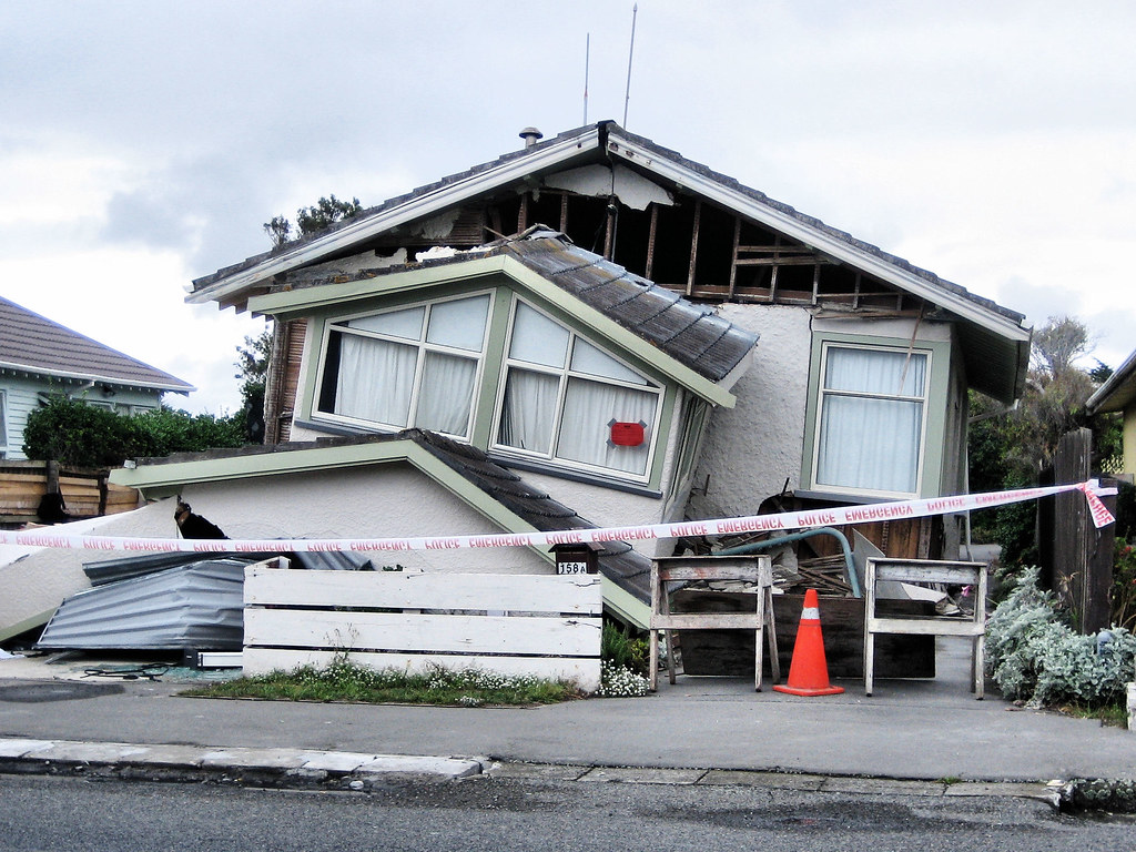
The infrastructure in the Midwestern states is much older than those in the West Coast, with many buildings in Midwestern cities being unreinforced masonries without any earthquake design or retrofitting plan because of the lack of attention, and the earthquake design of even modern structures very primitive. Honestly, this might be the most frightening aspect of the entire situation.
Many older structures are not protected against earthquakes because buildings are often used for decades before being replaced or substantially altered, making these existing buildings the single biggest contributor to seismic risk in the United States today. The very buildings where you work and live could become death traps.
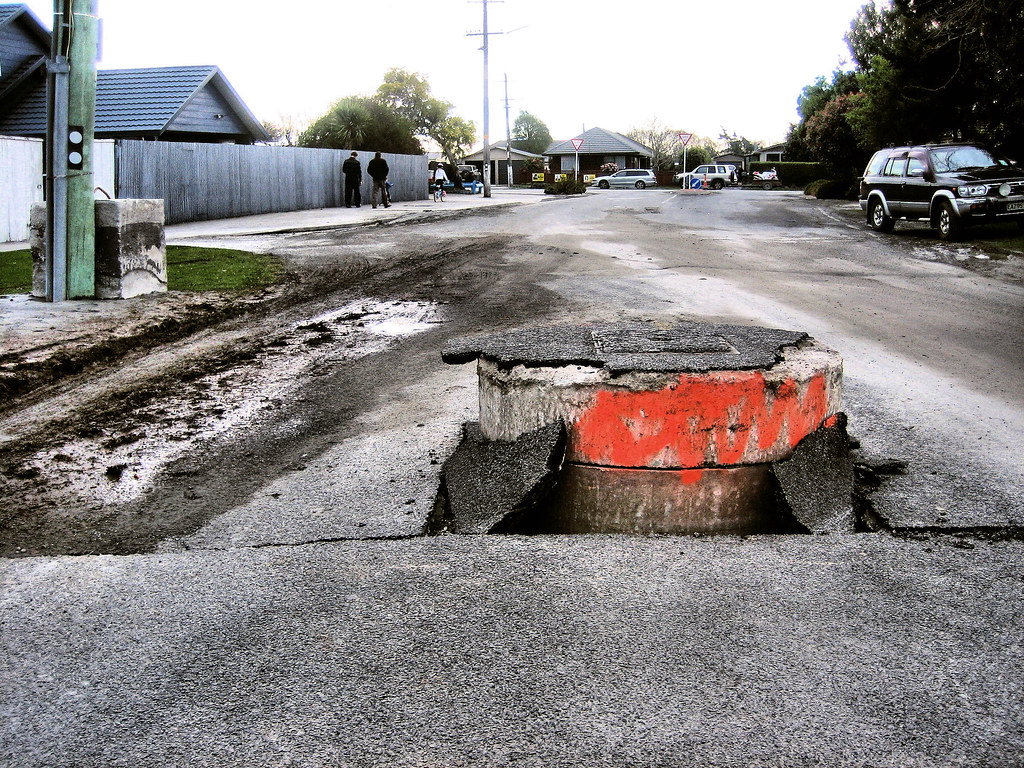
Buildings in St. Louis, 150 miles or more to the north, received damage consisting mostly of broken or collapsed stone chimneys and broken stone buildings of Unreinforced Masonry construction during the 1811-1812 earthquakes, and even today those URM old buildings, which have not been retro-fitted with safety features, are especially susceptible to earthquake damage.
The Science Behind the Silence
GPS measurements made since about 1996 do not show significant deformation across part of the New Madrid seismic zone, though these short-term observations must be tempered by the context of tectonic processes developed over many thousands to millions of years, as such long-term processes are unlikely to switch off in a few decades with an accompanying decrease in the earthquake hazard.
The Reelfoot Rift failed to split the North American continent but has remained as an aulacogen deep underground, and this relative weakness allows the relatively small east–west compressive forces associated with the continuing westward continental drift of the North American plate to reactivate old faults around New Madrid, making the area unusually prone to earthquakes despite being far from the nearest tectonic plate boundary.
The geologic record reveals that the New Madrid seismic zone has repeatedly produced sequences of major earthquakes over the past 4,500 years, with similarly large, widespread, and abundant prehistoric sand blows produced over the same area during previous clusters of large earthquakes around A.D. 1450, A.D. 900, and 2350 B.C., indicating that the older earthquakes were similar in location and magnitude to the 1811-12 shocks.
A Race Against Time
From a cultural viewpoint, many people in the Midwestern states are not aware of the potential hazard of prospective earthquakes, with insufficient education provided to the public about earthquake preparation and safety. This ignorance could prove deadly when the inevitable happens.
Officials note that general complacency builds because you never know when an earthquake can strike on the most volatile and dangerous fault system in the country, making being prepared for catastrophe essential. The unpredictability breeds dangerous overconfidence.
The probability of a repeat of the 1811-1812 earthquakes (magnitude 7.5-8.0) is from 7-10% and the probability of a magnitude 6.0 or larger is from 25-40%, though it is understood that a large magnitude event grows more probable with each passing day, and a catastrophic seismic event on the NMSZ could directly impact more than 50% of the state’s population.
The stakes couldn’t be higher. While California prepares for “The Big One,” the Midwest sits on an earthquake zone that could affect more people across a wider area than any disaster in American history. The question isn’t if another major earthquake will strike the central United States. The question is when, and whether we’ll be ready for what scientists already know is coming.
What’s your plan when the ground starts shaking in America’s heartland? Tell us in the comments.

Hi, I’m Andrew, and I come from India. Experienced content specialist with a passion for writing. My forte includes health and wellness, Travel, Animals, and Nature. A nature nomad, I am obsessed with mountains and love high-altitude trekking. I have been on several Himalayan treks in India including the Everest Base Camp in Nepal, a profound experience.