The Pacific Ocean looks like an unbroken blue expanse on a globe, but its floor is a patchwork quilt stitched over hundreds of millions of years. Hidden under miles of water, scientists are finding hints of sunken landscapes, continental scraps, and volcanic provinces the size of small countries. The question that keeps resurfacing is as dramatic as it sounds: did a true continent once hide beneath the Pacific? The short answer is that no single Atlantis-like landmass has been proved, yet a growing body of evidence points to vast regions of continental crust and colossal volcanic plateaus that blur old boundaries. The mystery now is not whether pieces exist, but how they fit together – and what their story tells us about Earth’s restless past.
The Hidden Clues
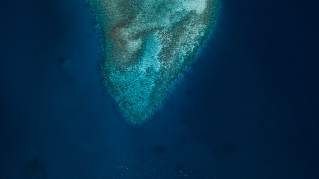
Start with the rocks themselves: granites, metamorphic schists, and ancient zircons that scream continent, not seafloor, dredged from ridges and plateaus east of Australia and north of New Zealand. Add satellite gravity maps and multibeam bathymetry that outline broad, buoyant swells – features like the Lord Howe Rise – that rise higher than normal oceanic crust. These lines and colors, once abstract, begin to sketch the silhouette of something larger, stitched from fragments now drowned.
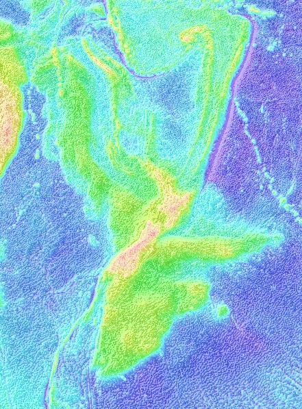
Perhaps the most compelling silhouette is Zealandia, a mostly submerged continent-scale block sprawling across the southwest Pacific. It is not myth; it is continental crust with the chemistry, thickness, and geology to match. Roughly 94% lies underwater, yet it behaves like the missing puzzle piece along Gondwana’s old seams. The clue, as always in geology, is consistency across many imperfect pieces that all point in the same direction.
From Ancient Tools to Modern Science
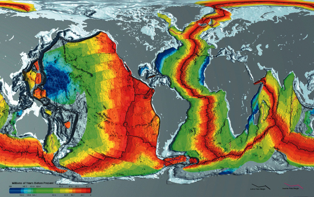
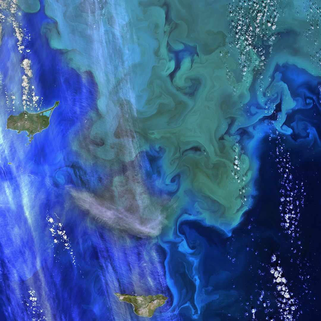
Early explorers mapped the Pacific with weighted lines and patience, tracing depth point by point like reading Braille. Today, ships sweep swaths of seafloor with multibeam sonars, while satellites sense tiny variations in sea-surface height that reveal mountains and basins below. These datasets do not just fill in coastlines; they redraw continents and plate boundaries in places nobody can see.
Seismic reflection profiles slice the crust like medical imaging, showing layered sediments draped over harder, older foundations. Ocean drilling recovers microfossils, volcanic ash, and mineral grains that nail down ages and past environments, sometimes revealing shallow-water life where deep ocean now rules. Put together with plate-reconstruction software and geochemical fingerprints, these tools transform scattered clues into testable histories with surprising confidence.
The Case for Zealandia
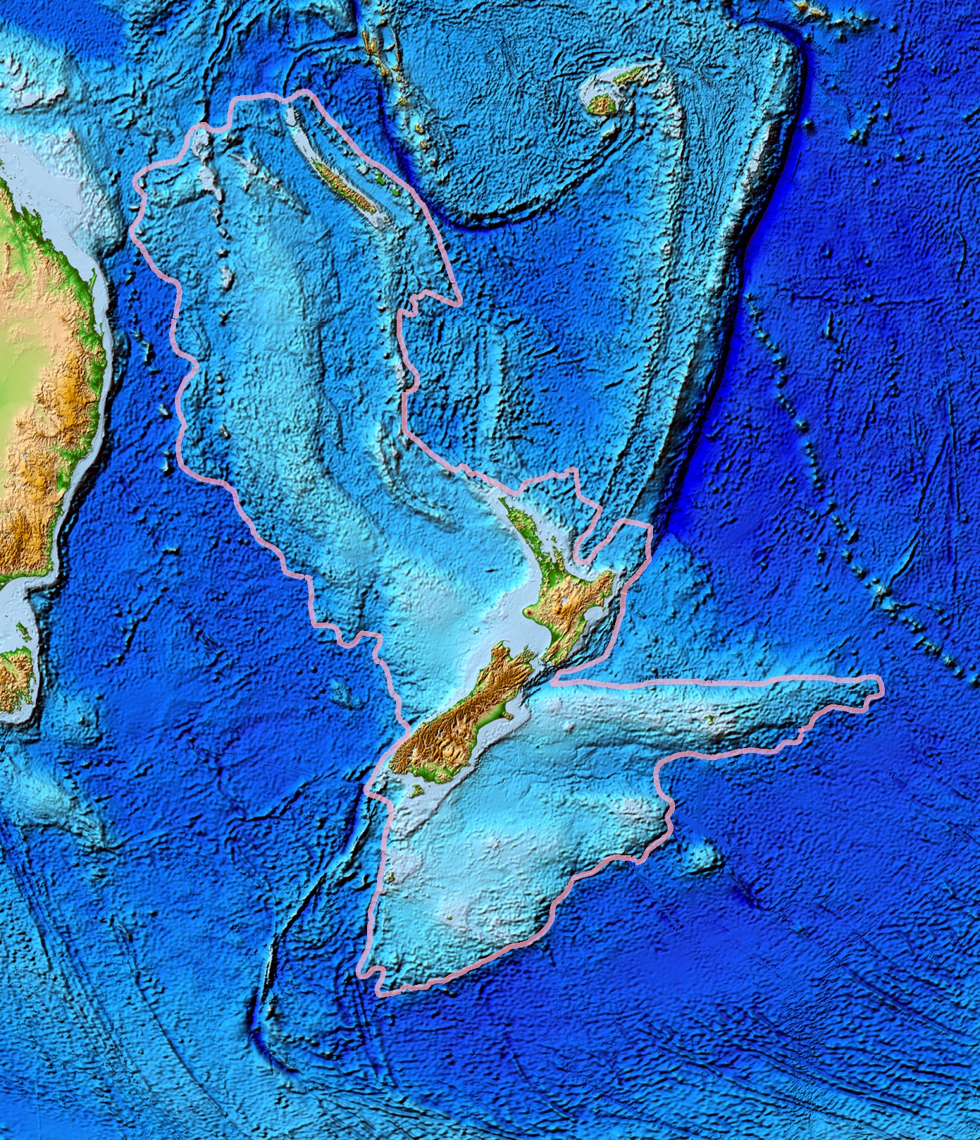
Geologists formally argued in the last decade that Zealandia meets the criteria for a continent: it is large, elevated relative to the abyssal plains, and composed of continental rock types. It stretches from New Zealand to New Caledonia and across the Lord Howe Rise, a ghostly archipelago of high-standing crust masked by water. Instead of a single catastrophic sinking, evidence points to a long breakup from Gondwana followed by thinning and subsidence.
Drilling and seismic data suggest parts of northern Zealandia were once nearer to sea level, with sediments and fossils that formed in shallower settings before the region sagged. Uplift and later drowning appear to have pulsed through the Paleogene, driven by shifting plate boundaries and mantle forces. Zealandia does not solve the entire Pacific mystery, but it proves that continental-scale crust can hide in plain sight beneath the waves.
Seismic X-rays of the Deep
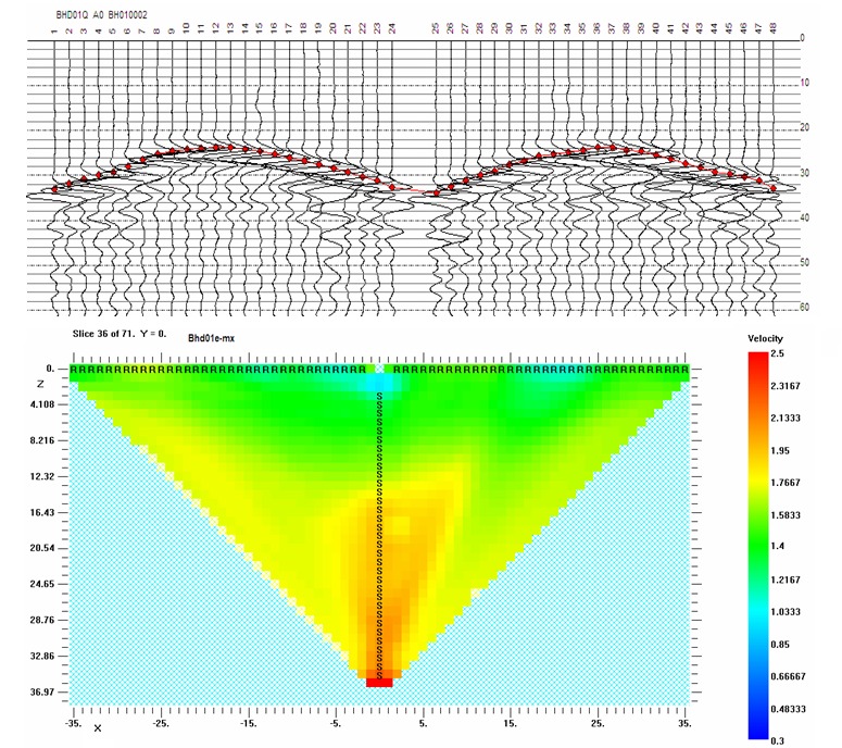
Seismic tomography – Earth’s version of a CT scan – maps slow and fast zones deep in the mantle, and the Pacific hosts one of the planet’s great anomalies. A vast low-shear-velocity province sits beneath the ocean, flanked by walls of subducted slabs that mark where ancient plates plunged and settled. These structures are not continents, but they shape how plumes rise and where volcanoes sprinkle the surface, from Hawaii to Samoa.
Closer to the crust, immense volcanic plateaus like Ontong Java, Manihiki, and Hikurangi speak of outbursts of magma around one hundred twenty million years ago. Their basaltic makeup is oceanic, yet their thickness rivals continental margins and they may have been born as a single giant complex before splitting apart. The line between continent and ocean blurs here, not through fantasy, but through geology’s habit of producing hybrids that defy simple labels.
Global Perspectives
The Pacific’s story echoes elsewhere: a Greater Adria fragment now welded under southern Europe, a vanished Argoland dispersed across the eastern Indian Ocean, and microcontinents peppering the Atlantic. These examples show that continental crust can be shaved off, thinned, and hidden, only to reappear as mountain roots or odd rock types on faraway shores. Terranes in Alaska and western Canada, for instance, look like travelers that crossed oceans before docking.
Such wanderers remind us to read coastlines as temporary truce lines rather than permanent borders. When continents splinter, they shed ribbons and shards that ride plates like passengers catching different trains. The Pacific, being the largest, naturally holds more passengers and more tangled itineraries, including pieces that look continental without ever assembling into a single drowned superland.
Why It Matters
Understanding whether a continent once hid beneath the Pacific reshapes how we reconstruct supercontinents, predict volcanic hazards, and estimate where critical minerals might reside. Continental crust is more buoyant and chemically distinct than oceanic crust, so its presence alters how plates collide, how mountains rise, and how earthquakes concentrate. It even nudges long-term climate, because continents modulate weathering rates that draw down carbon dioxide.
There’s also a reality check: myths imagine dramatic sinkings overnight, while geology favors slow-motion change over tens of millions of years. Comparing the two sharpens scientific literacy and improves how we communicate risk. Put plainly, chasing this mystery is not just academic; it informs resource planning, hazard mapping, and the stories we tell about a planet that is never at rest.
The Future Landscape
New tools are coming fast: fiber-optic cables that double as global seismometers, fleets of autonomous vessels mapping seafloor canyons, and machine learning that fuses gravity, magnetics, and seismic data into clearer crustal pictures. Ocean drilling campaigns continue to target key ridges and plateaus, seeking age pins and environmental markers that either connect or separate the fragments. Denser networks of ocean-bottom seismometers will sharpen tomography and expose hidden faults.
The biggest hurdle is coverage; vast stretches of the Pacific remain only coarsely mapped, like a half-developed photo. International efforts to chart the entire seabed aim to close that gap, but time at sea is precious and expensive. As resolution improves, expect some hypotheses to fall away while others harden into maps that future textbooks will take for granted.
Conclusion
You can help bring the hidden Pacific into focus by supporting open seafloor mapping initiatives and the museums and universities that curate ocean cores and rocks. Follow ocean exploration programs and share their findings; public attention makes expeditions easier to fund and sustain. If you work in tech, data science, or engineering, consider contributing to open datasets and tools that stitch marine measurements into accessible maps.
Closer to home, back policies that protect marine areas where science and conservation can proceed together, and reduce personal carbon footprints that amplify ocean stress. Curiosity matters too: ask questions, compare maps, and keep a skeptical eye on grand claims while cheering for real discoveries that make our planet’s deep past a little less mysterious.

Suhail Ahmed is a passionate digital professional and nature enthusiast with over 8 years of experience in content strategy, SEO, web development, and digital operations. Alongside his freelance journey, Suhail actively contributes to nature and wildlife platforms like Discover Wildlife, where he channels his curiosity for the planet into engaging, educational storytelling.
With a strong background in managing digital ecosystems — from ecommerce stores and WordPress websites to social media and automation — Suhail merges technical precision with creative insight. His content reflects a rare balance: SEO-friendly yet deeply human, data-informed yet emotionally resonant.
Driven by a love for discovery and storytelling, Suhail believes in using digital platforms to amplify causes that matter — especially those protecting Earth’s biodiversity and inspiring sustainable living. Whether he’s managing online projects or crafting wildlife content, his goal remains the same: to inform, inspire, and leave a positive digital footprint.