A tropical disturbance currently designated Tropical Depression Nine has drawn the attention of meteorologists and emergency managers, as it is expected to strengthen into Tropical Storm Imelda imminently and potentially escalate to hurricane status as it approaches the U.S. southeastern coastline.
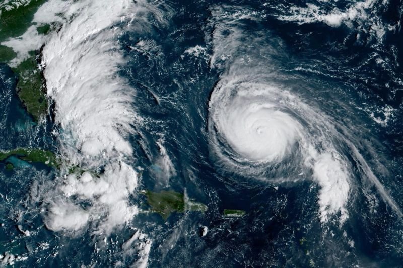
Over recent days, the system has moved slowly northward across the Bahamas, drenching islands already with heavy rains and flash flooding.
While earlier forecasts showed a possible direct hit on the Carolinas, more recent model guidance suggests Imelda may track just offshore—lessening but not eliminating the threat to coastal communities. Nonetheless, the system’s slow forward motion and interaction with a nearby hurricane (Humberto) complicate forecasts and raise concerns about flooding, high surf, and localized wind impacts even outside the storm’s core.
When And Where Imelda May Strike: Timing, Path, And Landfall Prospects
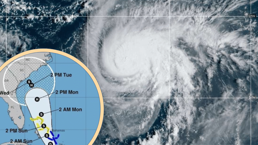
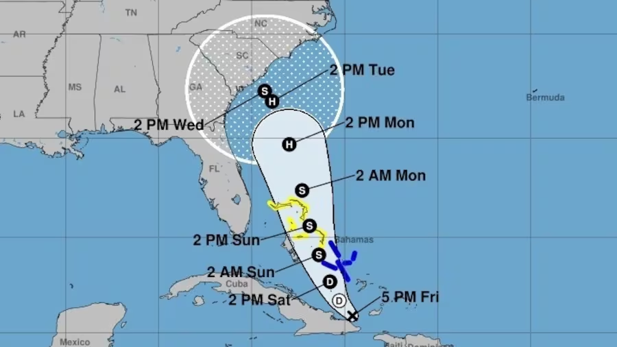
As of the latest advisories, Imelda is forecast to form (i.e. the depression to intensify to tropical storm strength) between late Sunday, September 28, and early Monday, September 29.
It is then expected to track northward through the Bahamas during Sunday, with heavy rains and tropical storm conditions across the islands.
By Monday into Tuesday, the system may run roughly parallel to Florida’s Atlantic coast, under a tropical storm watch for parts of the east coast of Florida (from Palm Beach northward toward Volusia).
Forecasts suggest that by Tuesday or Wednesday, Imelda could intensify into a Category 1 hurricane (or at least a strong tropical storm) while lying offshore of Georgia, South Carolina, or North Carolina.
Some model runs show the storm briefly stalling around the southeastern coast before curving back out to sea.
Importantly, direct landfall along the U.S. coast is no longer the most likely scenario. Many recent forecast ensembles favor a track that keeps Imelda just offshore, gradually veering east away from the coastline.
That said, the possibility of grazing impacts—heavy rain, flooding, storm surge, and strong winds over coastal zones—cannot be discounted, especially if the storm tracks closer than currently projected.
Areas At Risk And Intensity Forecasts And Regions Likely To Feel The Effects
The Bahamas and Cuba — As Imelda organizes over the Caribbean and migrates north, these areas are already under tropical storm watches and warnings, with flash flooding and heavy rainfall expected.
Florida’s Atlantic coast — Portions of east coast Florida are under tropical storm watch, with possible tropical storm conditions (gusty winds, rain, coastal flooding) beginning Monday.
Georgia, South Carolina, North Carolina (coast and nearshore) — These are the areas most likely to contend with the strongest impacts: prolonged heavy rainfall, storm surge, coastal flooding, and higher winds if Imelda hugs the coastline.
Inland and upper coastal zones — Even though inland penetration is less likely given current paths, flood risk from rain bands and localized gusts may extend into parts of Piedmont North Carolina and beyond.
Intensity And Severity Outlook
Forecasts suggest Imelda may strengthen into a low-end hurricane (Category 1) if environmental conditions remain favorable (warm ocean waters, low shear).
However, peak intensification is likely capped due to potential dry air entrainment, wind shear, and the storm’s slow movement stirring cooler water underneath.
Most projections now view Imelda as a tropical storm to a marginal Category 1 hurricane rather than a stronger system.
While the probability of catastrophic damage is lower than for a major hurricane, the flooding risk is elevated—especially in coastal and low-lying zones where storm surge and rain runoff may combine.
Strong rip currents and large surf are also expected to accompany Imelda along the U.S. coast, posing danger to swimmers and nearshore maritime activities.
Finally, complicating the forecast is the presence of Hurricane Humberto to the east. The mutual interaction between the two storms (a phenomenon sometimes likened to a “Fujiwhara effect”) may tug Imelda farther out to sea or alter its trajectory, contributing to forecast uncertainty.
Potential Impacts And Danger Signals
Even if Imelda remains offshore, the following hazards are of considerable concern:
Heavy rainfall and flooding — Rain totals of 4–8 inches are plausible along coastal zones, with isolated totals exceeding 10 to 12 inches in vulnerable zones (especially southern North Carolina).
Flash floods and urban flooding may occur, particularly in poorly drained areas.
Storm surge and coastal flooding — Even without landfall, onshore winds and high tides may push seawater inland along barrier islands and estuaries, flooding roads, piers, and low-lying coastal communities.
Strong winds and gusts — Tropical storm–force winds (say 40–60 mph) may occur in bands, especially along the coastline or over sea-facing exposures. Gusts could locally exceed forecasted wind thresholds under convective bursts.
High surf, dangerous rip currents, coastal beach erosion — The surf zone is likely to become treacherous, with large swells and strong rip currents extending far from the storm’s center. Swimming and boating may become hazardous well ahead of the core.
Slow storm motion hazard — Because Imelda is not forecast to rush through, prolonged exposure to heavy rain and onshore winds could worsen cumulative flooding and exacerbate storm surge compounding.
It is worth noting that inland zones farther from the coast are less likely to see direct wind damage, but flooding from rain bands remains a concern, especially in foothill or hilly terrain with drainage constraints.
- Preparedness: what communities and residents should do now
- Given the evolving nature of Imelda’s track and intensity, the following precautionary steps are strongly recommended:
- Monitor updates closely: Local, state, and federal weather services (e.g. National Hurricane Center, NOAA, and local offices) will issue routine advisories, watches, and warnings. Stay tuned to official forecasts.
- Heed tropical storm or hurricane watches/warnings: Especially along the east coast of Florida, Georgia, and the Carolinas, residents should be ready to act if warnings escalate.
- Prepare for flooding: Residents in flood-prone or low-lying zones should ensure that drainage around homes is clear, sandbags ready if available, and valuables are moved to higher ground.
- Secure property and outdoor items: Loose debris, patio furniture, lightweight structures should be tied down or brought indoors.
- Have an evacuation plan: Even though a landfall is not certain, some coastal or barrier-island communities may issue voluntary or mandatory evacuations if surge risk intensifies. Know your route and have alternative plans.
- Stock emergency supplies: Water, nonperishable food, batteries, flashlights, first aid kits, and backup power sources should be ready for potential power outages or delays.
- Avoid entering surf or coastal waters: Rip currents and powerful surf can be lethal well before the main storm arrives.
- Be cautious with post-storm flooding: After Imelda passes, flooding may persist or even worsen as rains drain—avoid driving through flooded roads and stay alert to further weather.
Local authorities, emergency responders, and residents should coordinate now to finalize plans, especially along the coastal zones likely to feel Imelda’s edge. Given forecast uncertainty, erring on the side of caution is wise.
While Imelda’s exact path and intensity remain subject to change, especially due to its slow motion and interactions with Hurricane Humberto, the storm still poses a genuine risk to coastal communities from unprecedented rainfall, surge, and dangerous surf. As forecasts refine in the coming 24–48 hours, close attention and early preparation may make a critical difference for at-risk areas.

Hi, I’m Andrew, and I come from India. Experienced content specialist with a passion for writing. My forte includes health and wellness, Travel, Animals, and Nature. A nature nomad, I am obsessed with mountains and love high-altitude trekking. I have been on several Himalayan treks in India including the Everest Base Camp in Nepal, a profound experience.