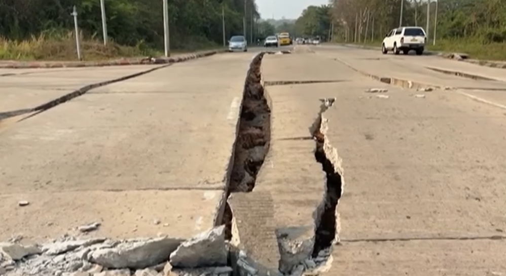
For those who do not know, in the early afternoon of March 28, 2025, central Myanmar was rocked by a magnitude 7.7 earthquake that would leave thousands dead and thousands more displaced. But what has fascinated scientists most isn’t only the human cost—it’s the extraordinary video of the Earth itself breaking open. A security camera at the Thapyawa solar farm, near Thazi, caught in dramatic detail the moment when the ground cracked—an actual surface rupture—as two tectonic plates along the Sagaing Fault shifted.
The footage shows a gate trembling, then a crack ripping across the ground driving a visual split in what was until then a quiet driveway. It is believed that this video is the first ever to capture such a through‐surface rupture in such raw, unedited real time. When watching the video, focus on the hill outside the gate which moves completely to one side. The earthquake was a rupture of about 460 kilometers (290 miles) of the Sagaing fault line that runs through most of Myanmar, causing shaking of up to intensity X on the Modified Mercalli scale. As heavy shaking was felt throughout much of Myanmar as well as other neighboring countries, the fault line moved side-to-side by as much 6 meters (20 feet) in some places, a movement which can be seen in this video. This is the first (and currently only) known instance of a fault line motion being captured on camera.
Fault Lines, Plates, and the Mechanics Behind the Crack
The quake occurred along the Sagaing Fault, a great strike‐slip transform fault where the Burma Plate and the Sunda Plate slide past each other. The epicenter was near Mandalay, to the north of the location of the solar farm video, but the rupture propagated both northwards and southwards along the fault.
What makes this event scientifically rich is how the rupture behaves. Geophysicists such as John Vidale and Rick Aster have noted that seeing a rupture reach the surface is itself rare; seeing it caught live, from so close to the fault, is nearly unprecedented. The crack didn’t move in simple fashion—it opened in what looks like a curved path, moving sideways and then spreading out as the surface broke apart. This curvature in the rupture is significant, suggesting different stresses at depth vs. near the surface, or changes in how the fault structure itself behaves as rupture propagates.
Measuring the Rupture: Speed, Slip, and Surprises
Using the video, scientists have been able to quantify how much ground moved and how fast. According to analyses: the fault slipped about 2.5 meters (≈ 8.2 feet) in just 1.3 seconds at the location captured by the camera. The slip velocity peaked around 3.2 meters per second (≈ 10.5 feet/s) before slowing and straightening out after the initial curved motion.
Furthermore, the slip dynamics appear “pulse-like”—that is, a rapid burst of movement rather than a gradual, uniform shift. This kind of behavior is of high interest because it can tell researchers about how energy is released during large quakes, and how the fault might behave at other segments. The curvature seen in the early stage of the rupture may reveal how the near-surface materials deform differently from deeper rock under high stress.
Human Toll and the Reach of the Quake
The earthquake was devastating. It is reported to have killed nearly 5,500 people, with extensive damage not only in Myanmar but also felt across borders, including strong tremors in Thailand.
The video came from the GP Energy Myanmar’s equipment at the Thapyawa solar farm, which allowed unique coverage of the rupture. Security cameras are rarely positioned in such fault‐trace proximity (i.e. nearly directly over where the crust will crack). This serendipity of location, combined with video that hasn’t been lost or distorted by the quake itself, gives scientists a window into processes that most of the time must be inferred rather than seen.
What This Means for Earthquake Science & Preparedness
Experts say this video marks a turning point in how earthquakes may be studied moving forward. Sewismologists like John Vidale at USC and Rick Aster at Colorado State say that having visual evidence of through‐surface rupture, complete with precise measurements of velocity, displacement, and curvature, gives a benchmark against which models and simulations can be tested.
The implications are practical as well. Better understanding of how faults rupture at the surface—how quickly, how far, in what shapes—can help in hazard mapping, building codes, and early warning systems. If scientists can trace similar signatures in satellite imagery or ground sensors elsewhere, then knowing what a rupture looks like in action means response plans can be more grounded (literally) in what actually happens during the worst quakes.
Conclusion: A Moment Frozen in Rupture
What unfolded in Thazi, Myanmar was more than just a disaster—it was a rare opportunity to witness one of Earth’s dynamic forces in motion. The crack that ripped through concrete, earth, and steel in just over a second may well become an iconic image in the field of seismology. It reminds us that faults are not abstract lines on a map but living structure that can suddenly, violently, heave, buckle, and split.
While the human tragedy remains at the heart of this event, scientists are working to ensure that from this footage, lessons will be drawn: better predictions, stronger infrastructure, more precise understanding of how the ground itself behaves when enormous forces push it beyond its limits. In the jagged crack that now marks the land near Thazi, there lies both a warning—and a new source of insight for us all.

Hi, I’m Andrew, and I come from India. Experienced content specialist with a passion for writing. My forte includes health and wellness, Travel, Animals, and Nature. A nature nomad, I am obsessed with mountains and love high-altitude trekking. I have been on several Himalayan treks in India including the Everest Base Camp in Nepal, a profound experience.