NASA’s Terra satellite took a stunning picture of the cosmos in May 2015. It showed six Atlantic islands painting the sky with swirling, hypnotic cloud spirals that covered more than 260,000 square miles (670,000 km²). These “von Kármán vortices” are one of the most beautiful atmospheric dances in nature. They got their name from the physicist who figured out what they were. It is very rare for so many of these ghostly swirls to show up at once, making the Atlantic a huge canvas for fluid dynamics. This phenomenon shows how the geography of the Earth affects the skies, from Madeira’s complex spirals to the Canary Islands’ interference patterns.
The Science Behind the Swirls: How Islands Sculpt the Sky
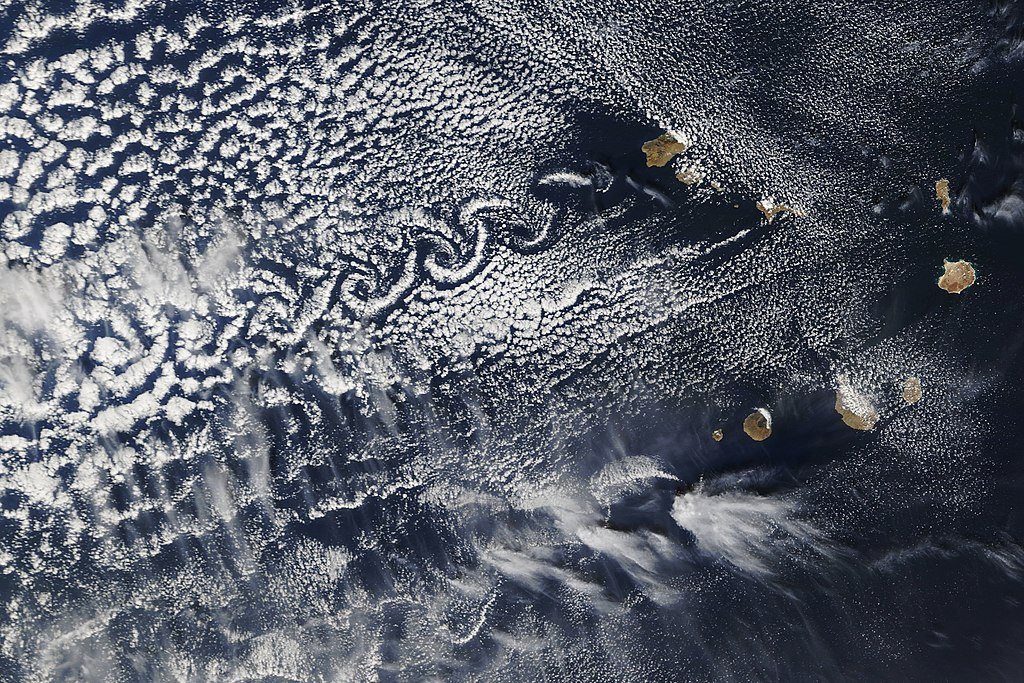
When steady winds hit tall landmasses, they break up the airflow into alternating whirlpools, which is how Von Kármán vortices form. NOAA says that these things, like island peaks, split the air and create a “double row of vortices” that spin in opposite directions downstream. Clouds serve as natural tracers, revealing these invisible air currents much like smoke in a wind tunnel. The 2015 photo shows this phenomenon perfectly: the rough terrain of Madeira made the most distinct spirals, and the vortices over the Canary Islands got so tangled that they almost cancelled each other out, which is a rare case of atmospheric interference.
A Record-Breaking Display: Why This Event Stood Out
This vortex parade was the first of its kind and covered an area bigger than France. NASA said that its size was much bigger than most recorded cases, and that the swirls in Madeira were perfectly symmetrical. The Canary Islands of La Palma, El Hierro, La Gomera, Tenerife, and Gran Canaria made things even more complicated. It’s interesting that vortices from La Gomera and Tenerife collided, cancelling each other’s rotations like two whirlpools fighting. Meteorologists don’t often get to see interactions like this, which are a live demo of fluid dynamics.
Island Hotspots: Where Earth’s Geography Creates Art
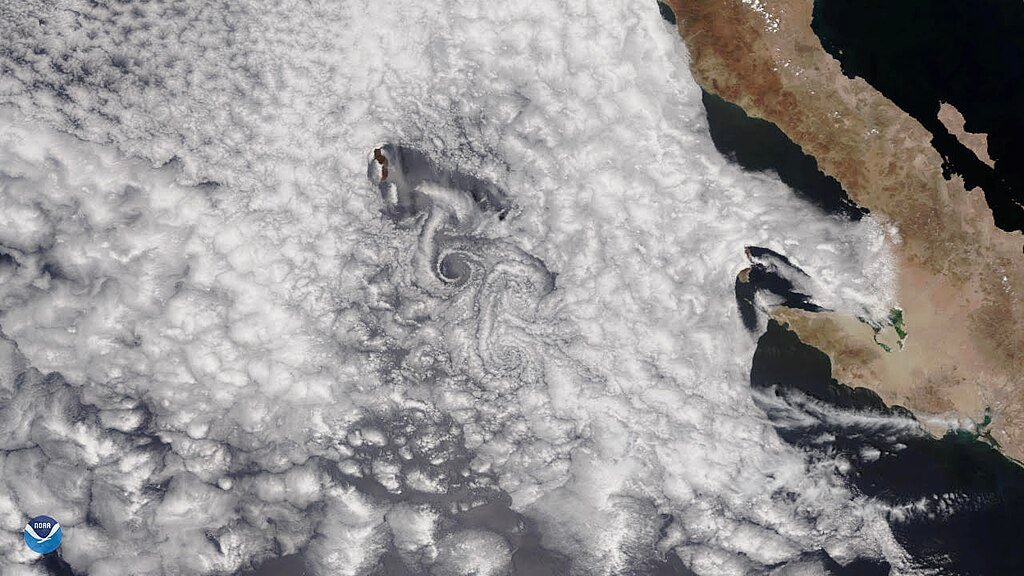
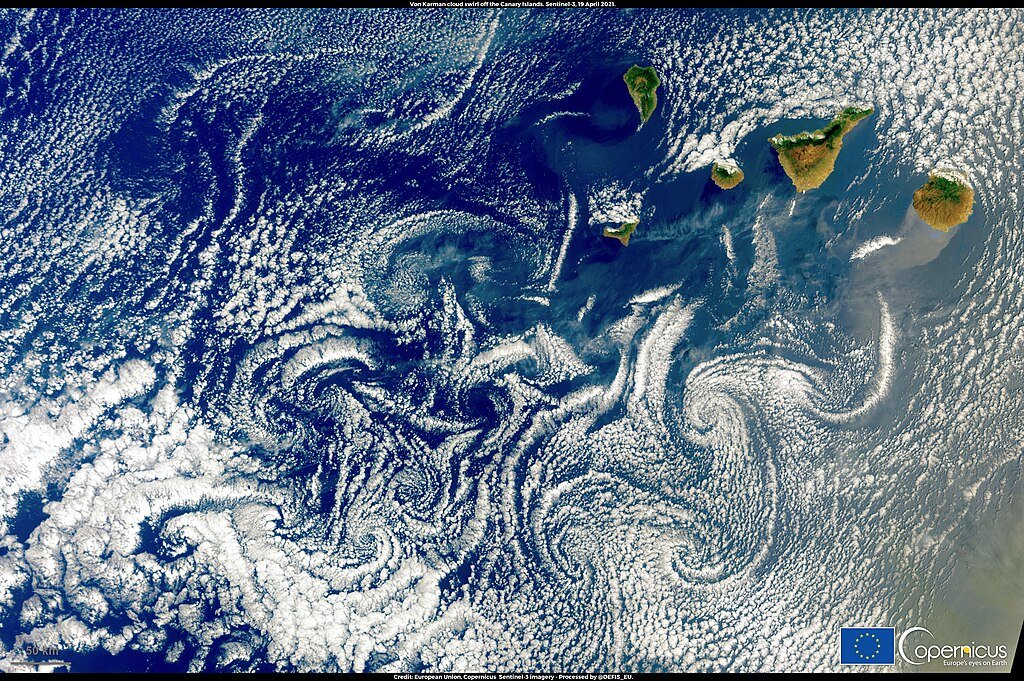
According to EUMETSAT, the best places to form vortices are Madeira and the Canary Islands because they are located within the tropics and their peaks are sufficiently distanced from each other. The Pico Ruivo in Madeira is 1,862 meters (6,109 feet) tall, while Teide volcano in Tenerife stands at 3,715 meters (12,188 feet) tall. Both of these peaks serve as natural windbreaks. While most of this is not just an Atlantic fluke, Guadalupe Island near Mexico also is known to spawn vortices quite frequently. The Arctic is not left out of these happenings; frozen peaks of Bear Island sculpting bizarre artworks from the sky and sea, hurricanes, and algae outbursts.
When Vortices Collide: The Mystery of Canceling Whirls
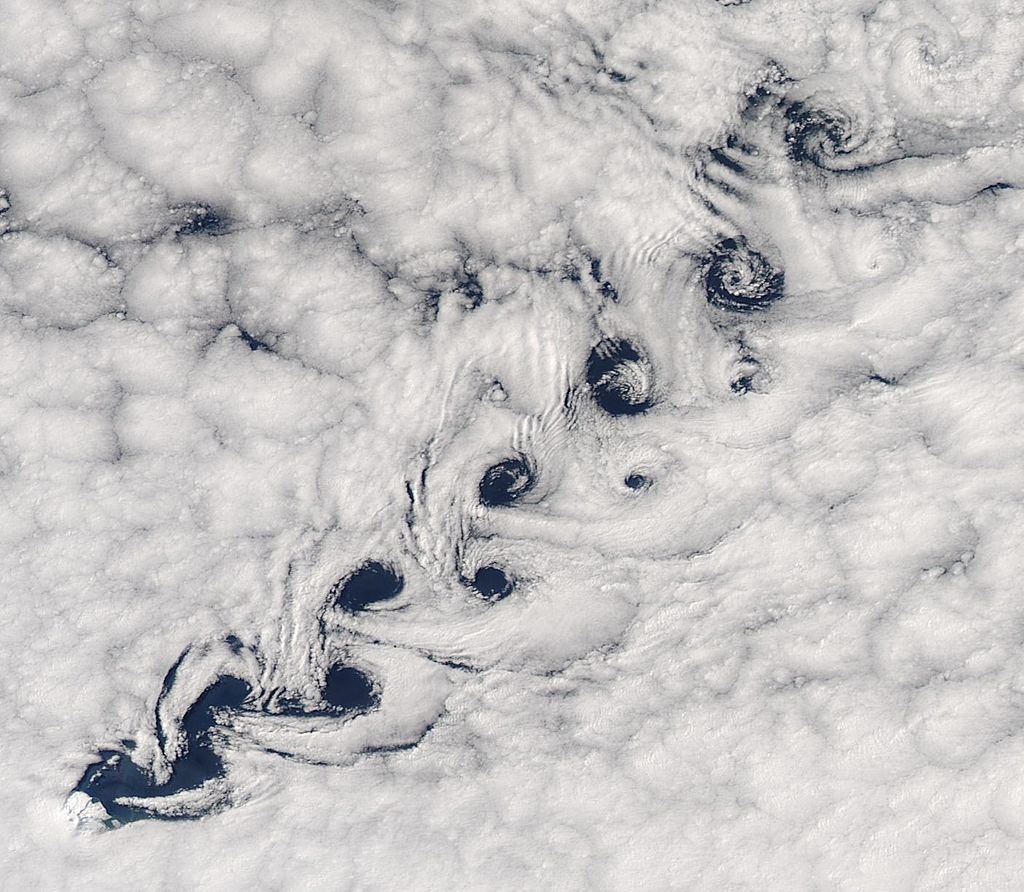
Scientists were confused by the Canaries’ interfering vortices. La Gomera and Tenerife’s whirls looked like they were cancelling each other out, just like sound waves do. This “destructive interference” shows that vortex streets that cross each other can mess up their own patterns, which is a rare occurrence. Researchers think that the distance between the islands and the wind shear might have something to do with it, but the 2015 image is still an important example for figuring out these aerial knots.
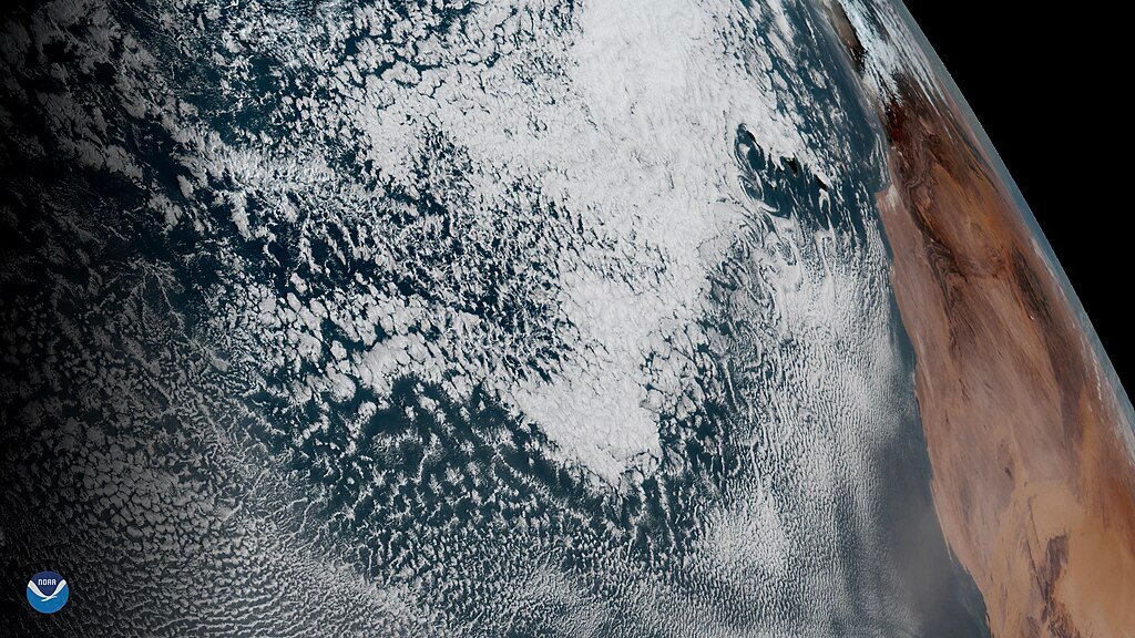
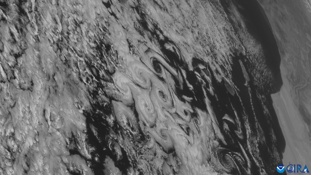
Beyond Clouds: Vortices’ Global Footprint and Odd Pairings
Vortices apply to mare’s tail clouds as much as they do ocean currents and zelfson dust storms in Mars atmosphere. Vortices were observed around buildings too. The 2015 Atlantic event was sighted next to a large “warp double rainbow” and the vortices nearby Bear Island were witnessed during 250 mile long algal bloom. According to EUMETSAT, Earth’s atmosphere is always exhibiting a perpetual swirl toy manufacturer and proves this by estimating new pairs of vortices formed everywhere on Earth every eight hours.
Climate Clues: What Vortices Reveal About Our Planet
The spirals are more than just pretty; they tell us about the weather. By looking at the size and duration of vortices, scientists can figure out how strong and turbulent the wind is. For instance, the sharp edges of Madeira’s vortices suggest stable, high-speed winds, while the frayed edges of the Canaries’ vortices suggest some stagnation and microclimatic activity. As more of these events are recorded by satellites, they may help us understand how the world’s rotational winds are changing as the planet warms.
Conclusion
The 2015 vortex show is still a good example of how art and science can work together to make beautiful weather. These things, like the algae-vortex duets in the Arctic and the cloud pretzels in the Atlantic, remind us that the atmosphere of Earth is a work of art that is always changing. Islands act as paintbrushes and winds hold invisible palettes. What else is up there in the sky that satellites are watching?
Sources:

Suhail Ahmed is a passionate digital professional and nature enthusiast with over 8 years of experience in content strategy, SEO, web development, and digital operations. Alongside his freelance journey, Suhail actively contributes to nature and wildlife platforms like Discover Wildlife, where he channels his curiosity for the planet into engaging, educational storytelling.
With a strong background in managing digital ecosystems — from ecommerce stores and WordPress websites to social media and automation — Suhail merges technical precision with creative insight. His content reflects a rare balance: SEO-friendly yet deeply human, data-informed yet emotionally resonant.
Driven by a love for discovery and storytelling, Suhail believes in using digital platforms to amplify causes that matter — especially those protecting Earth’s biodiversity and inspiring sustainable living. Whether he’s managing online projects or crafting wildlife content, his goal remains the same: to inform, inspire, and leave a positive digital footprint.