Imagine standing on a mountainside where the ground beneath your feet moves so imperceptibly that it takes decades to notice, yet possesses enough force to tear apart highways and reshape entire valleys. This isn’t science fiction – it’s the fascinating reality of Wyoming’s creeping landslides, where mountains literally move in slow motion, creating some of Earth’s most dramatic geological theater.
The Silent Power of Earth’s Patient Giants

Have you ever wondered what it would look like if mountains could walk? In Wyoming, that question isn’t hypothetical. What’s happening in this Wyoming resort town might be better described as a land creep than a landslide, but the lack of speed has not hindered the sheer power of the moving earth. Picture a massive chunk of mountainside deciding to take a leisurely stroll downhill, moving so slowly that you could literally watch paint dry faster, yet with enough unstoppable force to snap houses in half like twigs. The ground had been moving initially at a rate of an inch a day. That’s is expected to speed up as time goes on, said George Machan, a landslide specialist consulting for the town. It’s like watching geological time in fast-forward – if fast-forward meant waiting months to see any real change. Creep — Slow, imperceptible, downward flow of soil or rock material along the surface of a slope. This seemingly innocent process harbors tremendous destructive potential, transforming familiar landscapes one grain of soil at a time.
Wyoming’s Landslide Capital Status

Wyoming isn’t just another state with some geological quirks – it’s practically the landslide capital of America. Parts of Wyoming have some of the highest landslide densities in the United States. Think of Wyoming as nature’s own laboratory for studying how mountains fall apart in spectacular slow motion. The WSGS has mapped more than 30,000 landslides throughout the state. That’s roughly one landslide for every 20 residents! Landslides occur every year in Wyoming, however, most occur in remote areas and do no typically cause damage. It’s like living in a giant geological experiment where the mountains are constantly rearranging themselves, usually when nobody’s watching. Most landslides mapped in Wyoming are classified as being complex. These aren’t your simple rock-falls-down-hill scenarios – they’re intricate dances of earth, rock, and gravity that can take decades to fully unfold.
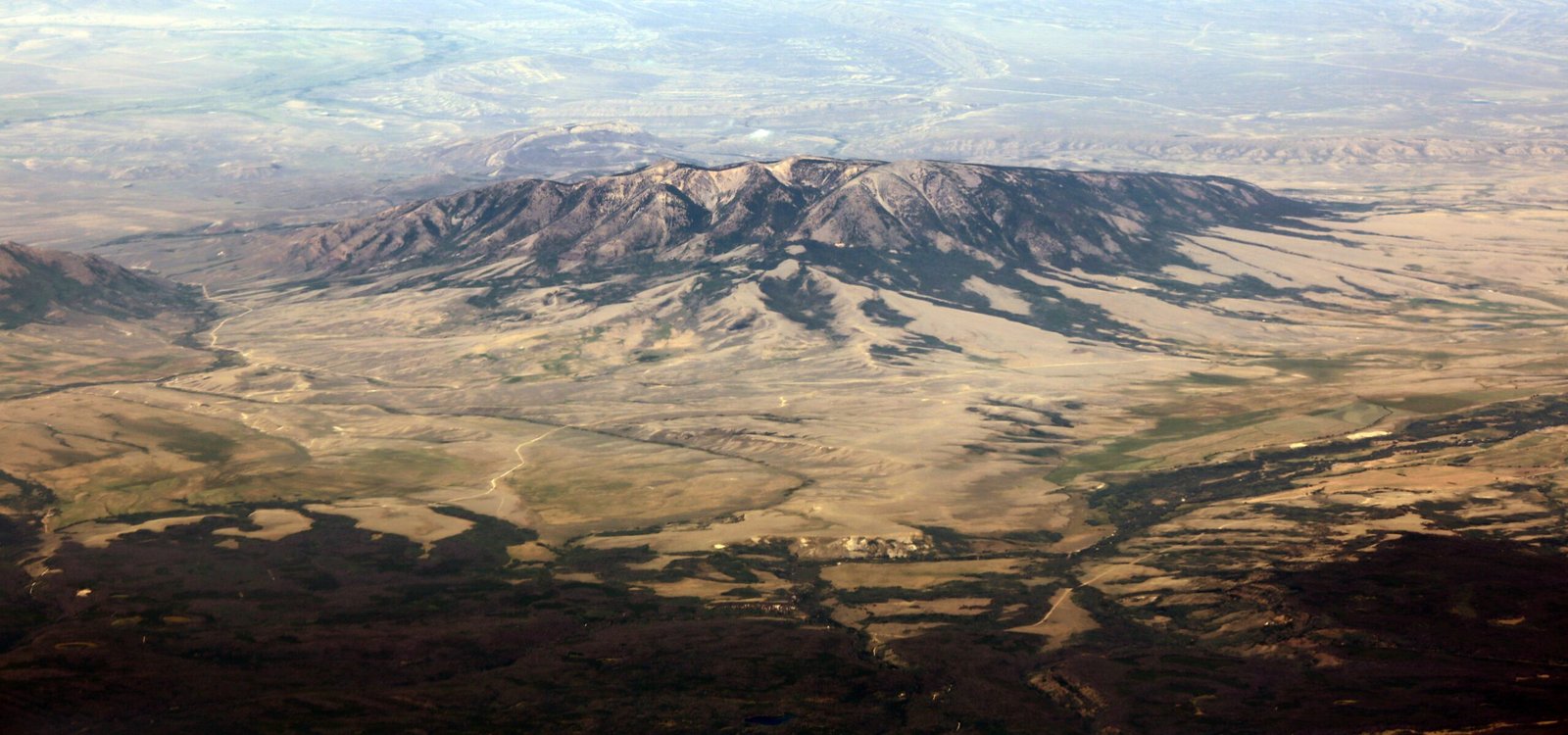
The Heart Mountain Giant That Redefined Slow

The largest known subaerial landslide is the Heart Mountain Landslide in northwestern Wyoming. This is the largest subaerial landslide that has been recognized. But here’s the mind-bending part: Although this landslide occurred about 50 million years ago, it was so large that weathering, erosion, and volcanic activity have not yet obscured all of the evidence. Imagine a landslide so massive that it’s still leaving calling cards 50 million years later! At least 3,500 km2 of land slid during the HMD, which is an area larger than the size of Rhode Island! In this slide a 400-square-mile slab of Madison Limestone was detached, started to slide and broke into dozens of smaller pieces. Some of these pieces moved over 30 miles during the slide. It’s like Mother Nature decided to rearrange her furniture and moved an entire state’s worth of rock across the landscape. This prehistoric giant makes today’s “slow” landslides look like speed demons in comparison.
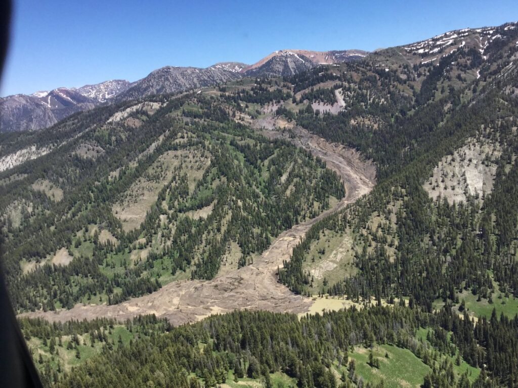
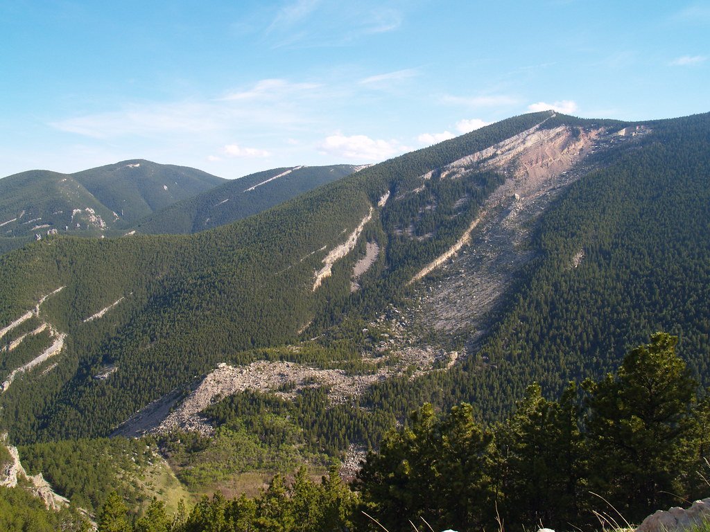
The Teton Pass Drama: When Slow Turns Catastrophic

Nothing illustrates Wyoming’s landslide personality quite like the recent Teton Pass collapse, where decades of patient creeping suddenly turned into a highway-swallowing monster. WYDOT has been monitoring this creeping slide for decades. This road section of road was re-paved in 2004 and patched last fall after slow, consistent creep over the past 20 years. Picture road crews playing an endless game of whack-a-mole with a mountain that just wouldn’t stay put. Prior to this incident, the slide moved less than an inch per year. Then suddenly, like a sleeping giant waking up grumpy, A perfect storm of rain early in the week, followed by a rise in daily temps, and overnight temps above freezing resulted in rapid snow melt that saturated groundwater conditions which exponentially sped up this slide movement to the failure we saw June 8. A landslide caused the roadway at Teton Pass in Wyoming to collapse and crumble, in what the state’s department of transportation described as a catastrophic failure Saturday. It’s like watching a slow-motion disaster suddenly hit the fast-forward button.
The Science Behind Wyoming’s Creeping Mountains

Understanding why Wyoming’s mountains move so slowly requires diving into the fascinating world of soil mechanics and geological patience. Creep is the slow, continuous, imperceptible downslope movement of soil and rock particles. Think of it like a geological conveyor belt that operates at the speed of a sloth having a bad day. Cohesive flows in earth include soil creep, solifluction, earth flows, and debris laden earth flows. Soil creep and solifluction in earth are similar to those in debris. Earth flows are very slow to rapid flows that have a distinct source area, a main flow track, and a lobate depositional area. The magic happens when water acts like nature’s lubricant, turning solid mountainsides into something that behaves more like very thick honey. Rock type, slope angle, hydrology, and geologic structure are some of the major factors that determine whether an area is prone to landslides. It’s a perfect storm of geology, gravity, and water working together to create Earth’s slowest dance moves.
Jackson’s Creeping Neighborhood Nightmare

In Jackson, Wyoming, residents got a front-row seat to watch their neighborhood literally slide away in slow motion, like a real-life disaster movie played at quarter speed. Over the past two weeks, a piece of East Gros Ventre Butte has slowly collapsed toward the west side of Jackson — shearing one hillside home in half, threatening to devour several others and looming ever more ominously over a cluster of businesses below. Imagine waking up each morning to see your house a little bit closer to falling off a cliff, but not quite close enough to panic about it today. Town officials first noticed significant hill movement on April 4. They evacuated 42 homes and apartment units on April 9. No one can say precisely when the mountainside will cease its slow droop into Jackson or finally give way. But it appears increasingly likely that it’s going to take a piece of Jackson with it. It’s like living under a geological sword of Damocles that moves at the speed of continental drift.
The Economic Earthquake of Slow-Motion Disasters

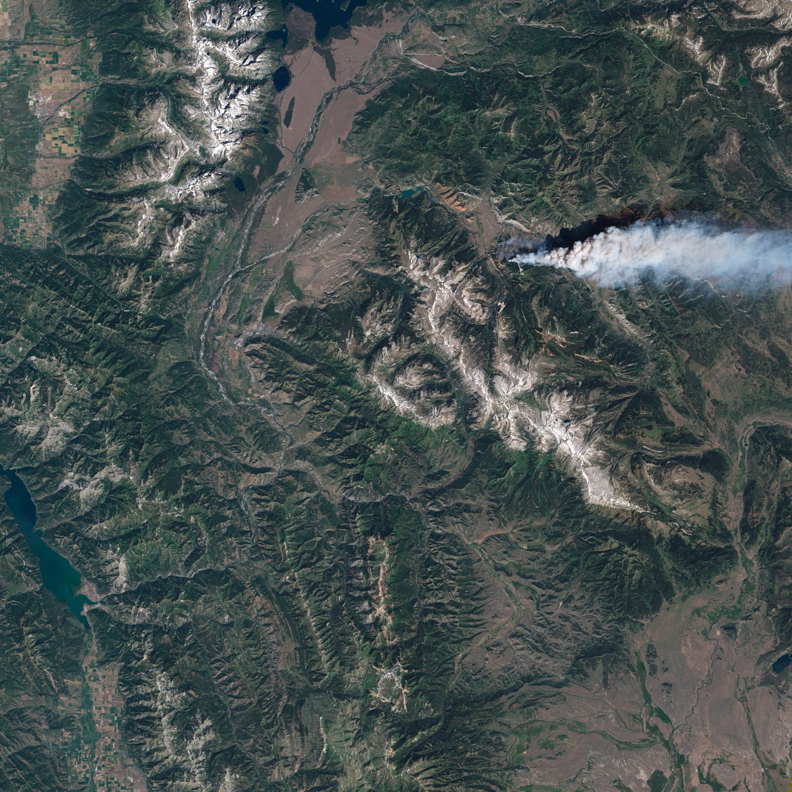
When mountains move slowly, the economic impacts can be anything but gradual, creating ripple effects that spread faster than the landslide itself. A landslide that wiped out a vital two-lane road in western Wyoming is causing a mountain of headaches for thousands of commuting tourist town workers at the outset of the Yellowstone region’s busy summer season. After the slide sent both lanes crashing into a ravine near Teton Pass on Saturday, it’s anybody’s guess when Wyoming Highway 22, between Jackson, Wyoming, and eastern Idaho, will reopen. On average, more than 2,500 people commute daily from Idaho to Jackson, which is in the wealthiest county in the United States, per capita, the county housing authority said. “The landslide really shines a ton of light on how unsustainable our community is,” said Jacob Gore, a Wyoming native who lives in Idaho because of rising costs. “I just accepted that I will never own a home in Jackson unless I win the lottery.” It’s like watching economic dominoes fall in slow motion, where a crawling mountainside triggers a cascade of financial consequences that move much faster than the earth itself.
Modern Technology Meets Ancient Processes

Today’s scientists have turned into geological detectives, using cutting-edge technology to monitor mountains that move like they’re swimming through molasses. Most recently, WYDOT’s geologists installed an inclinometer, a device that measures subsurface slide movement, in the fall of 2023 to monitor this area. Think of these instruments as geological stethoscopes, listening to the slow heartbeat of moving mountains. He added that states can also monitor land that’s slowly moving with new technologies, though it’s still tough to say when it’ll turn into a big slide like the one on Teton Pass. It’s like trying to predict when a ticking time bomb will explode, except the bomb ticks once every few months and might explode tomorrow, or in fifty years, or maybe never. The Wyoming State Geological Survey (WSGS) welcomes reports of recent or active landslides. The WSGS is currently updating its landslide database. Scientists are essentially crowd-sourcing their mountain-watching efforts, turning every Wyoming resident into a potential geological early warning system. The challenge remains: how do you prepare for a disaster that unfolds over decades but can suddenly accelerate without warning?
Climate Change and the Acceleration of Slow Motion

Global warming isn’t just melting ice caps – it’s literally speeding up Wyoming’s slowest geological processes, turning patient landslides into impatient ones. Mohammed Ombadi, a climate scientist and professor at the University of Michigan, said mountain towns are hotspots for extreme rain and snowmelt due to warming temperatures. “With continued global warming, we expect more landslide events, soil erosion, flooding particularly in mountainous regions,” Ombadi said. Picture climate change as nature’s accelerator pedal, pressing down on geological processes that have been content to crawl for millennia. On Teton Pass, experts say high temperatures and rapid snowmelt triggered the June 8 slide, since the soil was oversaturated with water. National Weather Service meteorologists attributed heavy spring rainfall in combination with a significant snowmelt, which led to an increase in landslides and flooding. Temperatures of 10-20 degrees above average caused the ice and snow at higher elevations to rapidly melt, filling rivers and drainage tributaries. It’s like putting Wyoming’s geological processes on fast-forward, where “slow” landslides suddenly discover they can move much faster than anyone expected. Ombadi said communities should see that disaster as a “wake-up call” to the kinds of damages predicted to come with a warming climate.
The Complex Dance of Different Landslide Types

Wyoming’s landslides aren’t one-trick ponies – they’re more like geological Swiss Army knives, combining multiple types of movement into complex, slow-motion choreography. For example, many landslides in the State are slump/earth flow complexes. That type of landslide is composed of a slump at its head, with the main body and deposit being an earth flow. Imagine a geological dance where the mountain starts with a graceful bow (the slump), then flows into an elegant slow-motion waltz down the hillside (the earth flow). Block streams are slow moving tongues of rocky debris on steep slopes, and are often fed by talus cones. Talus flows are slow flows that occur in the basal portions of talus slopes. Rock glaciers are not true landslides, but have been included in the classification scheme because they are mass movements composed of coarse debris. Interstitial ice between debris fragments plays a role in the movement of rock glaciers, which are similar in form to a true glacier. These aren’t just rocks falling down hills – they’re complex geological performances that can take decades to complete, with each type of movement contributing its own tempo to the overall symphony of slow-motion destruction.
The Historic Gros Ventre Disaster: When Slow Goes Fast
Sometimes Wyoming’s slow landslides remind everyone that they can suddenly decide to sprint, as the Gros Ventre landslide demonstrated with devastating consequences in 1925. The landslide occurred on June 23, 1925, following melt from a heavy snowpack, several weeks of heavy rain, and earthquake tremors in the area. Approximately 50,000,000 cu yd (38,000,000 m3; 1.4×10⁹ cu ft) of primarily sedimentary rock slid down the north face of Sheep Mountain, crossed over the Gros Ventre River and rode up the opposite mountainside a distance of 300 feet (91 m). Picture 50 million cubic yards of rock deciding to relocate all at once – that’s enough material to bury Manhattan under 15 feet of debris. The landslide created a large dam over 200 feet (61 m) high and 400 yards (370 m) wide across the Gros Ventre River, backing up the water and forming Lower Slide Lake. On May 18, 1927, part of the landslide dam failed, resulting in a massive flood that was six feet (1.8 m) deep for at least 25 miles (40 km) downstream. In the early 1920s, a massive slide caused by heavy rains north of Jackson formed a natural dam across a small river. The dam gave way two years later, unleashing a flood that killed six people. It’s a sobering reminder that Wyoming’s patient landslides can suddenly lose their temper with catastrophic results.
Monitoring the Unmoveable Movers
Keeping tabs on landslides that move slower than growing fingernails requires the patience of a geologist and the precision of a watchmaker. The landslides were mapped over a 15-year period by the Geologic Hazards Section of the Wyoming State Geological Survey. Over 850 7.5-minute quadrangles have been mapped for landslides. Imagine spending 15 years methodically cataloging every place where mountains might decide to take a stroll – it’s like creating a geological census of Wyoming’s most restless residents. If a GPS system is used to identify the location of the landslide, locations should be taken at the base of the slide if possible. If not, please report where the GPS locations were taken, and in which direction from the coordinates the landslide is located. Please be extremely cautious as landslides can create difficult terrain. Don’t put yourself in danger to gather a GPS location on a landslide. Scientists have to balance the need for precise measurements with the reality that they’re studying something that could decide to speed up without warning. It’s like being a geological tightrope walker, gathering data while standing on terrain that might literally disappear beneath your feet.
Living and Building in Slow-Motion Hazard Zones

Constructing infrastructure in Wyoming means accepting that the ground beneath your feet might have plans of its own, creating an eternal chess match between engineers and geology. Basically, anytime you build a road through a mountain range, you run the risk of potential landslides. Departments of Transportation across the country work hard to mitigate the risk of road failure. If transportation officials only built roadways in landslide free areas, it would be hard to connect communities throughout the Rocky Mountain Region, or any mountain range. Without these roads, communities would be isolated without access to economic resources and emergency services. It’s like playing geological Russian roulette, where the stakes are measured in millions of dollars and years of planning. Human activities, such as road construction and surface water diversion, can also have an impact on landslide occurrence. Sometimes humans accidentally wake up sleeping landslides, like poking a dozing geological giant with a construction stick. This includes constant monitoring and drilling/sampling investigations, as well as pursuing and completing projects to address drainage improvements and better road design to improve weight distribution to discourage ground movement. Engineers have become geological psychologists, trying to convince unstable slopes to behave themselves through careful drainage therapy and weight distribution counseling.
The Endless Dance of Stone and Time
Wyoming’s moving mountains represent one of nature’s most patient but relentless forces, operating on timescales that dwarf human experience while occasionally accelerating into moments of dramatic change. From the prehistoric catastrophe that created Heart Mountain to the modern creeping slides that threaten infrastructure and communities, these geological processes reveal the dynamic nature of what we typically consider solid and permanent. This mind-boggling landslide has often elicited more questions than answers, but over the decades geologists have pieced together the evidence into a compelling theory. The story of Wyoming’s landslides teaches us that the Earth beneath our feet is neither stable nor predictable, but rather a restless foundation constantly shaped by forces deep within the planet. What appears to be a fixed and immovable landscape is, in fact, in slow motion—grinding, shifting, and occasionally collapsing in dramatic fashion. In Wyoming, this reality is etched into the very terrain, where layers of rock tell tales of ancient upheavals and modern instability. The massive detachment of Heart Mountain, once dismissed as impossible, now stands as a striking example of gravity’s long game and the complex interplay of tectonics, erosion, and time. Today, scientists continue to monitor subtle earth movements using satellite data and ground-based sensors, not only to protect lives and infrastructure but also to deepen our understanding of these majestic but moody mountains.