Imagine standing on the muddy banks of a Pacific Northwest river and seeing the ghostly stumps of ancient trees rising from beneath the water, their roots still clutching the earth after centuries. These silent sentinels, known as Seattle’s drowned forests, are more than just haunting relics—they’re living clues to the region’s secret and violent past. Their story isn’t just about trees or even about forests, but about the earth itself shaking, swallowing, and reshaping the land in a matter of moments. Are you ready to uncover how these sunken giants tell a tale of earthquakes, tsunamis, and survival that reaches back thousands of years?
The Discovery of the Drowned Forests
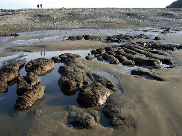
The discovery of Seattle’s drowned forests reads almost like a detective novel. Local fishermen and scientists first stumbled upon ancient stumps poking out of the tidal flats and riverbeds around Puget Sound. These stumps weren’t recent casualties of logging; they were rooted deep, preserved, and clearly old beyond memory. As researchers dug deeper—sometimes literally—they uncovered stumps and logs so well-preserved that tree rings could still be counted. This unexpected find set off a wave of curiosity. What had happened to drown a whole forest? The answer, it turned out, would reveal a hidden history of natural disasters. The forests became a living museum, keeping secrets beneath silt and water for generations.
What Exactly Is a Drowned Forest?
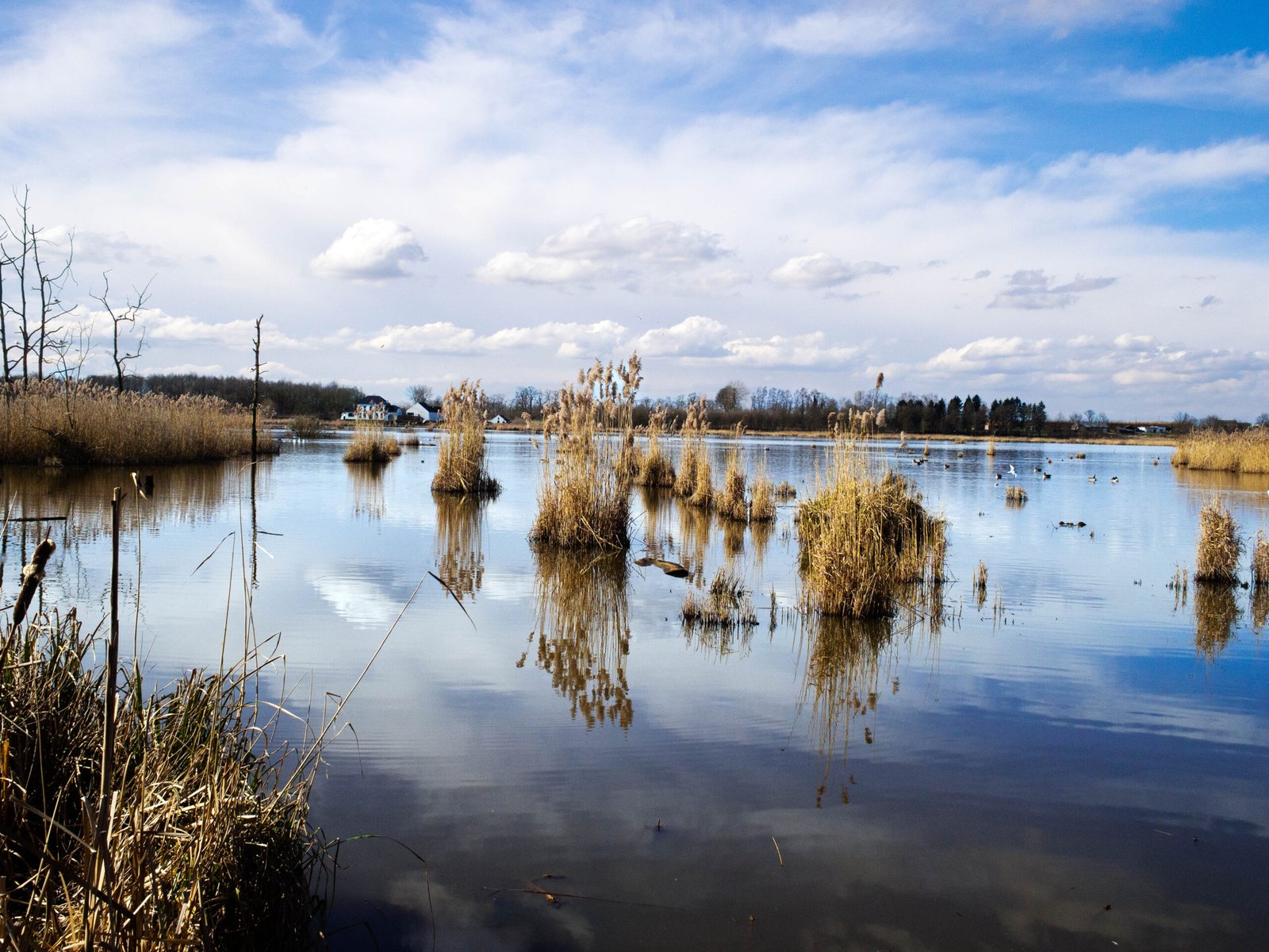
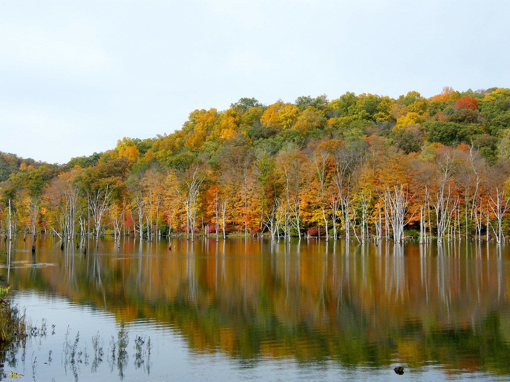
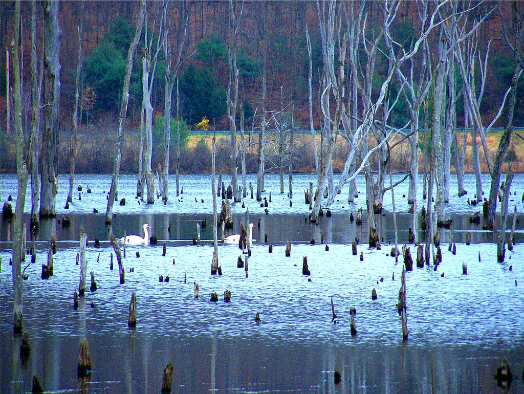
A drowned forest, in the simplest terms, is a stand of trees that once grew on dry land but now sits underwater or in marshy ground. The trees themselves can be remarkably intact, looking almost as if they could be revived with a little sunlight. In Seattle, these forests line riverbanks and the edges of the Puget Sound, their roots anchored where they fell centuries ago. The water acts as a natural preservative, slowing decay and protecting the wood from insects and fungi. Sometimes, visiting these sites feels like stepping into a natural time capsule. Unlike ordinary fallen trees, these stumps tell a story of sudden and dramatic change. Their presence begs the question: what catastrophe brought about their watery fate?
The Power of Earthquakes in the Pacific Northwest
Seattle sits in a region that’s no stranger to shaking ground. The Cascadia Subduction Zone, lying just off the coast, is capable of producing some of the most powerful earthquakes on the planet. For centuries, people thought the Pacific Northwest was relatively safe from major quakes. But the drowned forests told a different story. When scientists began to study the tree rings and sediment layers, they found evidence of abrupt land subsidence—where whole stretches of ground suddenly dropped several feet. This kind of geological event is almost always linked to massive earthquakes. The realization was shocking: Seattle’s peaceful landscape hid a violent past just beneath the surface.
The Tsunami Connection
Earthquakes are only half the story; tsunamis complete the picture. When the land dropped during a massive quake, it triggered waves that swept inland, flooding forests and burying roots in mud. The evidence is plain in the sediments: layers of ocean sand overlying forest soils, with tree stumps trapped in between. This kind of geological fingerprint is unmistakable. It tells us that the quiet waters of Puget Sound have, at times, surged with terrifying force. The drowned forests became silent witnesses to these tsunamis, their fate sealed by walls of water and debris.
Clues in the Tree Rings
Tree rings are nature’s diary, recording seasons of growth and sudden catastrophe. Scientists studying the drowned forests of Seattle use dendrochronology—the science of tree-ring dating—to pinpoint the exact year these trees died. In some cases, all the trees in a grove stopped growing in the same year, a clear sign of a single, catastrophic event. These simultaneous deaths coincide with geological evidence of earthquakes and tsunamis. By matching tree-ring patterns across the region, researchers can trace the reach and timing of ancient disasters. The rings also reveal periods of drought, fire, and even volcanic eruptions, but none so sudden as the events that drowned the forests.
Buried in Silt: How the Forests Were Preserved
Preservation in the drowned forests is almost eerie in its perfection. When seawater rushed in after an earthquake, it brought with it loads of silt and sand. This thick blanket settled over the forest floor, sealing stumps and roots away from air and decay. The waterlogged environment slowed the breakdown of wood by microorganisms. As a result, some trees have survived for hundreds—or even thousands—of years, their bark and wood still recognizably intact. The preservation is so good that you can sometimes see the marks left by ancient beavers or woodpeckers. It’s like nature pressed the pause button in the middle of catastrophe.
Native Legends and the Human Perspective
Long before scientists pieced together the puzzle, local Indigenous peoples had their own explanations for the drowned forests. Coastal tribes like the Quileute and the Makah told stories of “great shaking” and “waves that swallowed the land.” These oral histories often described entire villages disappearing beneath the ocean overnight. Today, scientists are amazed at how closely these legends match the evidence found in tree rings and sediments. The stories were more than just myths—they were warnings, passed down through generations. Listening to these voices from the past gives us a richer, more human sense of the forests’ fate.
Mapping the Extent of the Sunken Trees
One of the most astonishing facts is just how widespread these drowned forests are. They’re not limited to one small area; they pop up all around the edges of Puget Sound and along major rivers like the Duwamish and Nisqually. Modern mapping techniques—including aerial photography and sonar scanning—have revealed vast stretches of submerged stumps. These discoveries suggest that the ancient disaster wasn’t a local fluke, but a regional catastrophe that reshaped hundreds of square miles. Even today, construction projects sometimes uncover new patches of drowned forest, adding fresh pieces to the puzzle.
Seattle’s Unique Geological Setting

Seattle is perched at a geological crossroads, where several tectonic plates meet and grind together. The city sits on a patchwork of fault lines, unstable soils, and ancient riverbeds. This makes it especially vulnerable to the kinds of sudden land shifts that can drown a forest. The land beneath Seattle is still moving, flexing and settling as the plates shift. Scientists now use the drowned forests as a warning: what happened once could happen again. The ground that feels so solid beneath our feet is, in reality, always changing.
Lessons for Modern Science
The drowned forests of Seattle have become a textbook example for geologists around the world. They offer a rare, direct link between living ecosystems and sudden geological events. By studying these ancient trees, scientists have learned to spot the warning signs of earthquakes and tsunamis in other regions. The forests also challenge old assumptions—reminding us that even stable-looking landscapes can be shaped by violence. For local researchers, each new discovery is a reminder of how much we still have to learn from the natural world.
Connecting Past Disasters to the Present
The lessons of the drowned forests aren’t just academic—they have real, urgent implications for people living in the Pacific Northwest today. As researchers piece together the history of past disasters, they’re able to predict what kinds of events might happen in the future. These predictions shape building codes, emergency planning, and community awareness. The forests stand as silent reminders that disaster can strike with little warning, and preparation is the key to survival. It’s a humbling realization, but also an empowering one: knowledge gives us the chance to act before the next great quake.
How Scientists Date the Disasters
Getting the timing right is crucial, and the drowned forests make it possible. Scientists combine tree-ring studies with radiocarbon dating of organic material buried in the silt. Sometimes, they even find layers of volcanic ash from known eruptions, which act as time markers. By piecing together all this evidence, researchers have pinpointed major earthquakes and tsunamis to specific years—even specific seasons. This level of detail is rare in earth sciences, where so much is usually guesswork. The forests have become a kind of geological calendar, marking the moments when everything changed.
A Glimpse Into Seattle’s Prehistoric Landscape
It’s hard to imagine what the Seattle area looked like before the drowned forests were underwater. The region was once covered in dense, towering stands of western red cedar, Douglas fir, and Sitka spruce. These forests teemed with life: bears, elk, and salmon thrived in the cool, shaded streams. When you look at the drowned stumps today, you’re peering into a window on this lost world. The forests are a reminder that the landscape we know now was shaped by forces far older than any city or road.
The Role of the Drowned Forests in Modern Ecology
Surprisingly, the drowned forests still play a part in Seattle’s ecosystem. The submerged stumps and logs create habitat for fish, birds, and insects. Salmon fry hide among the roots, and herons hunt for minnows in the shallow water. The decaying wood releases nutrients back into the environment, feeding new generations of plants. In this way, the forests aren’t just relics—they’re living parts of the landscape, still shaping the cycles of life and death even centuries after they fell.
Unraveling the Mystery With Technology
New technology has transformed the study of drowned forests. Ground-penetrating radar, drone surveys, and underwater cameras have revealed details that would have been invisible just a decade ago. Scientists can now create 3D models of sunken root systems or analyze trace minerals in the wood. These tools have confirmed what Indigenous people and early researchers already suspected: the forests died in the blink of an eye. Technology continues to unlock new secrets, shedding light on mysteries that once seemed unsolvable.
Preparing for the Next Big Event

The drowned forests aren’t just a story about the past—they’re a warning for the future. Seattle sits on shaky ground, and scientists believe another massive earthquake could strike at any time. By studying how the ancient forests drowned, emergency planners can better understand which areas are at risk of flooding or land subsidence. Public agencies hold drills, stockpile supplies, and update evacuation routes with these lessons in mind. The forests have become more than a curiosity; they are part of the city’s survival plan.
Personal Stories From the Field
For those who have visited the drowned forests, the experience is unforgettable. One researcher described the feeling as “walking among ghosts,” with tree stumps stretching away into the mist. Local residents sometimes stumble upon ancient logs while digging in their gardens or walking along the beach. Each discovery is a small connection to the past—a reminder that history isn’t always written in books. Sometimes, it’s etched in the landscape, waiting to be uncovered by anyone with a curious mind.
Why the Story Captivates Us
There’s something deeply moving about the drowned forests. Maybe it’s the sense of time, or the way they bridge the gap between nature’s beauty and its raw power. They remind us that the world can change in an instant and that even the mightiest trees can fall. But the forests also tell a tale of resilience—of how life returns, and how stories survive through generations. For Seattleites and science lovers alike, these sunken groves are proof that the past is never really gone; it’s just waiting beneath the surface.
What We Still Don’t Know
Despite everything we’ve learned, the drowned forests still hold mysteries. How many times has the land beneath Seattle shifted so violently? Are there more ancient forests buried deeper, waiting to be found? Could new data change our understanding of when and how these disasters struck? Scientists continue to search for answers, digging, probing, and testing. Each new discovery adds another piece to the puzzle, deepening our appreciation for the forces that shape our world.
Looking Ahead: Living With the Lessons of the Past
The story of Seattle’s drowned forests isn’t finished. As climate change and urban development alter the landscape, new challenges and questions arise. Will future generations remember the lessons etched in silt and wood? Will we use this knowledge to build safer, more resilient communities? The forests urge us not to forget—to listen to the land, to respect its power, and to prepare for whatever comes next. Are you ready to see what lies beneath your own feet?