Across the world, stone and earth still whisper secrets that modern science is only just beginning to decode. For decades, ancient monuments were dismissed as the work of superstition, brute labor, or simple trial and error, but new research is revealing something far more unsettling: many of these sites embody scientific insights that seemed to vanish for centuries, even millennia. From precision alignments with the stars to surprisingly sophisticated engineering tricks for stability, acoustics, and climate control, these structures suggest that our ancestors knew more than we once thought. As archaeologists, physicists, and engineers revisit old ruins with new tools, they are finding carefully encoded knowledge about nature, materials, and mathematics. The story that emerges is not about magical lost civilizations, but about how human scientific understanding can bloom, disappear, and be rediscovered.
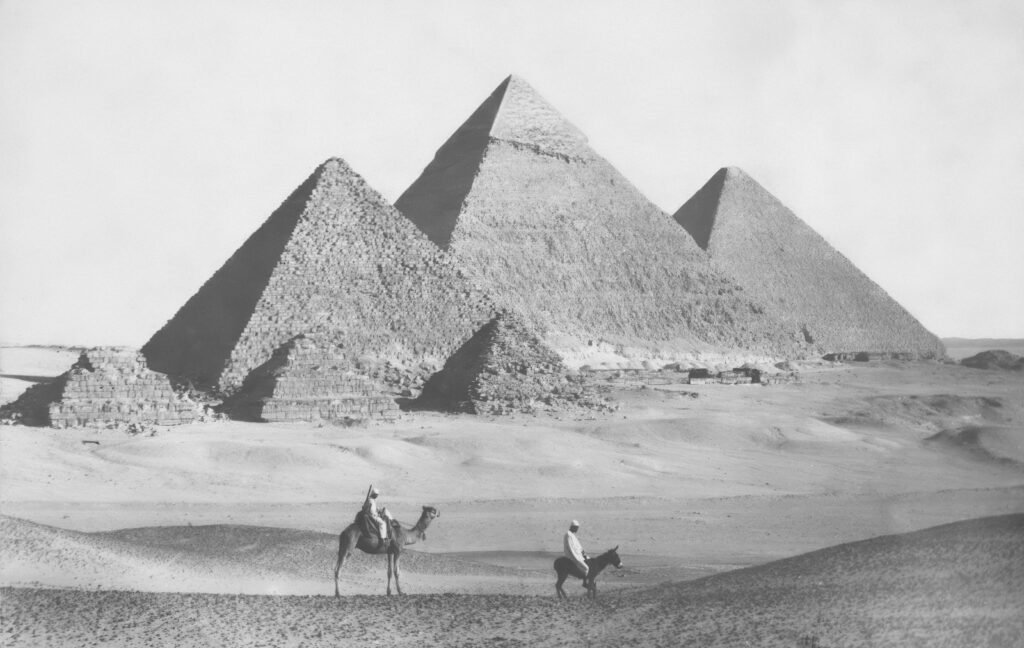
The Great Pyramid of Giza: Precision, Resonance, and Forgotten Engineering
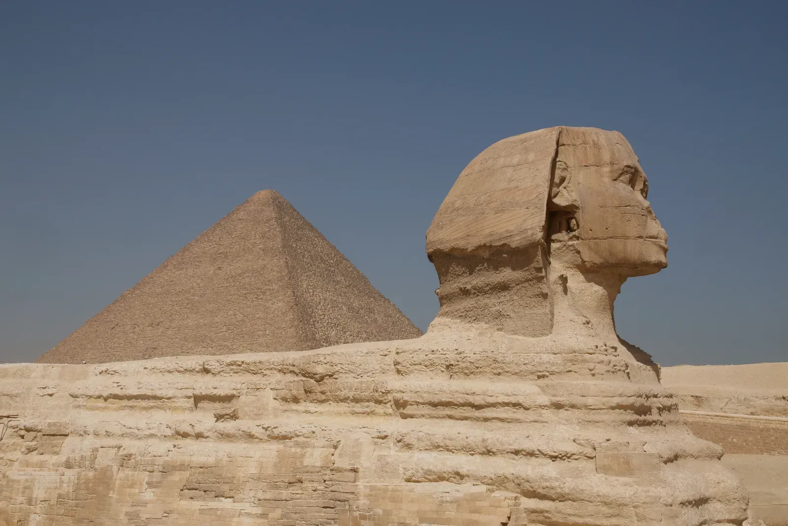
The Great Pyramid is so overexposed in popular culture that it is easy to forget how technically shocking it still is. Its base is aligned with true north to a precision that rivals modern surveying, despite being built more than four thousand years ago. Engineers studying its internal layout have pointed out that the pyramid’s long, narrow shafts line up closely with specific stars as they would have appeared in the ancient sky, indicating a refined understanding of celestial motion. That kind of astronomical accuracy does not happen by accident; it suggests years of sky-watching and a robust method for translating angular measurements onto the ground. For a long time, this observational science was written off as “religious symbolism,” but the data increasingly shows a culture that merged ritual with rigorous sky-based geometry.
Recent research into the pyramid’s stone cavities has sparked renewed interest in its physical properties. Some studies suggest that at certain frequencies, the internal chambers can concentrate and distribute mechanical vibrations, a kind of passive resonance effect that hints at an intuitive grasp of acoustics and structural dynamics. Whether this was deliberately engineered or a by-product of trial and error remains debated, but even accidental discoveries require builders who recognize and exploit what works. The sheer stability of the structure, with millimeter-level settling over thousands of years, also points to advanced knowledge of foundation engineering on soft desert bedrock. In many ways, the Great Pyramid is a fossilized textbook of geometry, material science, and structural design that we are only now learning to read properly.
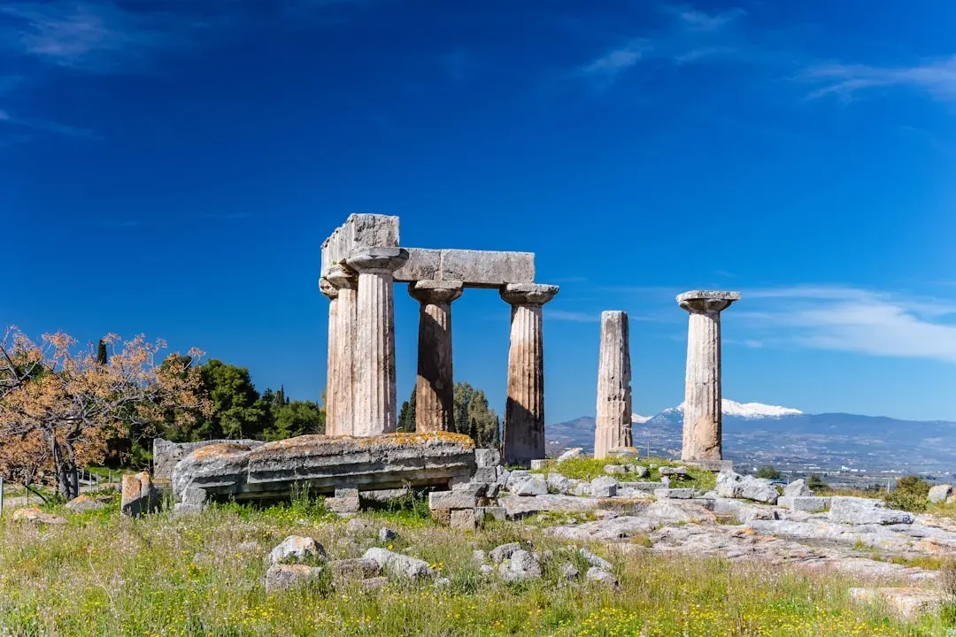
Stonehenge: Megalithic Astronomy and Cycles in the Sky
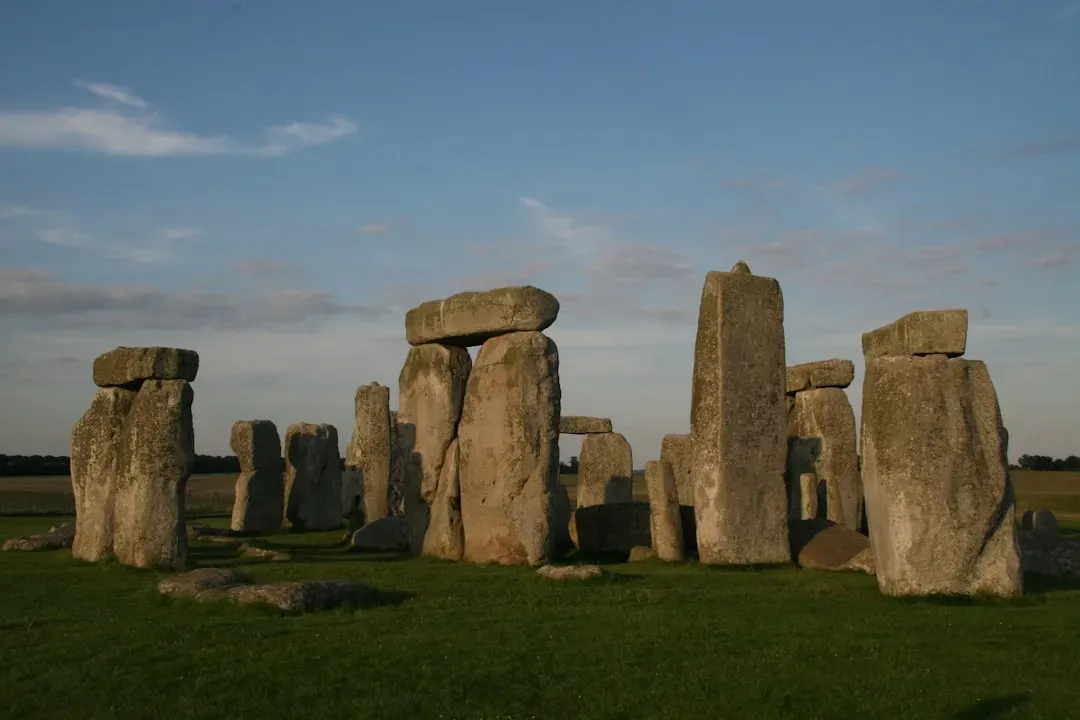
Stonehenge tends to be framed as a spiritual monument, a convenient stage for solstice photos, but under the romance lies a serious body of astronomical and geometric knowledge. The stones are arranged in a way that marks the extremes of the sun’s annual path, effectively encoding a solar calendar into the landscape. Some alignments also appear to track lunar cycles, which are much harder to map because the moon’s path is more complex and drifts over time. Creating a monument that can signal key turning points in both solar and lunar cycles suggests that its builders followed the sky for multiple generations, noticing slow, subtle patterns. That is not casual stargazing; it is long-term data collection turned into architecture.
Archaeological surveys have revealed that Stonehenge did not stand alone, but formed part of a larger, highly organized ritual and observational complex in the surrounding landscape. Timber circles, processional avenues, and sightlines to distant hills or river bends all seem to play roles in tracking celestial events. Modern archaeoastronomers use computer models to reconstruct the ancient skies and test which alignments are statistically likely to be intentional. The picture that emerges is of a Neolithic society that turned scientific observation into social glue, embedding astronomical knowledge in ceremonies, festivals, and even burial practices. Much of that sophisticated observational tradition was lost in later centuries, leaving behind only the stones and a puzzle for modern science to solve.
Teotihuacan: Urban Planning, Cosmic Angles, and Hidden Hydraulics
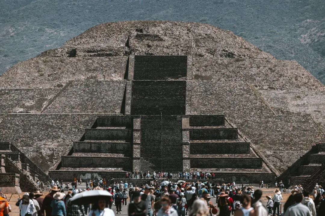
North of today’s Mexico City, the ancient city of Teotihuacan still feels like a deliberate experiment in how to engineer a civilization. Its main avenue, often called the Avenue of the Dead, is laid out on a grid offset from true north by a specific angle that appears to correspond to the setting of certain bright stars and the sun on key agricultural dates. This blend of city planning and celestial timing suggests that its builders used astronomy as a design tool, locking cosmic cycles into the geometry of daily life. The Pyramids of the Sun and Moon stand at carefully chosen sightlines, creating visual corridors where the sun appears to rise or set in dramatic alignments at particular times of the year. This makes the entire city a kind of giant calendar you can walk through.
Recent excavations have added another layer of scientific intrigue below ground. Tunnels discovered beneath the Pyramid of the Feathered Serpent contain traces of mercury-like liquid and carefully engineered drainage features, hinting at complex hydraulic and symbolic practices. Some researchers argue that the city’s designers were experimenting with water management, pressure control, and reflective surfaces to create ritual environments that also demonstrated control over natural forces. The way Teotihuacan integrates geometry, hydrology, and astronomy into a unified urban design challenges the stereotype of ancient cities as organic, unplanned growth. It points instead to lost traditions of urban engineering, planning codes, and environmental modeling that would not look out of place in a modern sustainability workshop, just expressed in a different scientific language.
Machu Picchu: Seismic Savvy and Sustainable Mountain Design
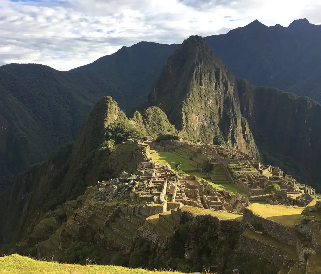
Machu Picchu is often romanticized as a lost city in the clouds, but it is also a masterclass in applied mountain science. Built on a knife-edge ridge in a seismically active region, the Inca citadel has survived countless earthquakes that have devastated younger structures in the same region. Its ashlar masonry, with precisely cut stones that interlock without mortar, allows the walls to flex and settle without collapsing, a clever response to frequent ground shaking. The terraces that cascade down the slopes are not just for beauty or food production; they are sophisticated earth-retention and drainage systems that stabilize the mountain itself. In many ways, Machu Picchu is a living model of geotechnical engineering wrapped in stone and soil.
Hydraulic engineering is another area where the site reveals deep practical science. A network of fountains, channels, and culverts collects and distributes spring water through the city, ensuring supply while preventing destructive erosion. Engineers who have modeled the flow patterns and soil structure describe the system as surprisingly close to modern best practice in slope management and stormwater control. The fact that the site remained relatively intact and functional until its abandonment speaks to a culture that understood ecological limits and mechanical risks better than many later builders. When we talk about “,” Inca mastery of mountain environments deserves a central place in the conversation, especially as we face contemporary challenges of landslides and high-altitude urbanization.
Göbekli Tepe: Deep-Time Data and the Birth of Structured Observation
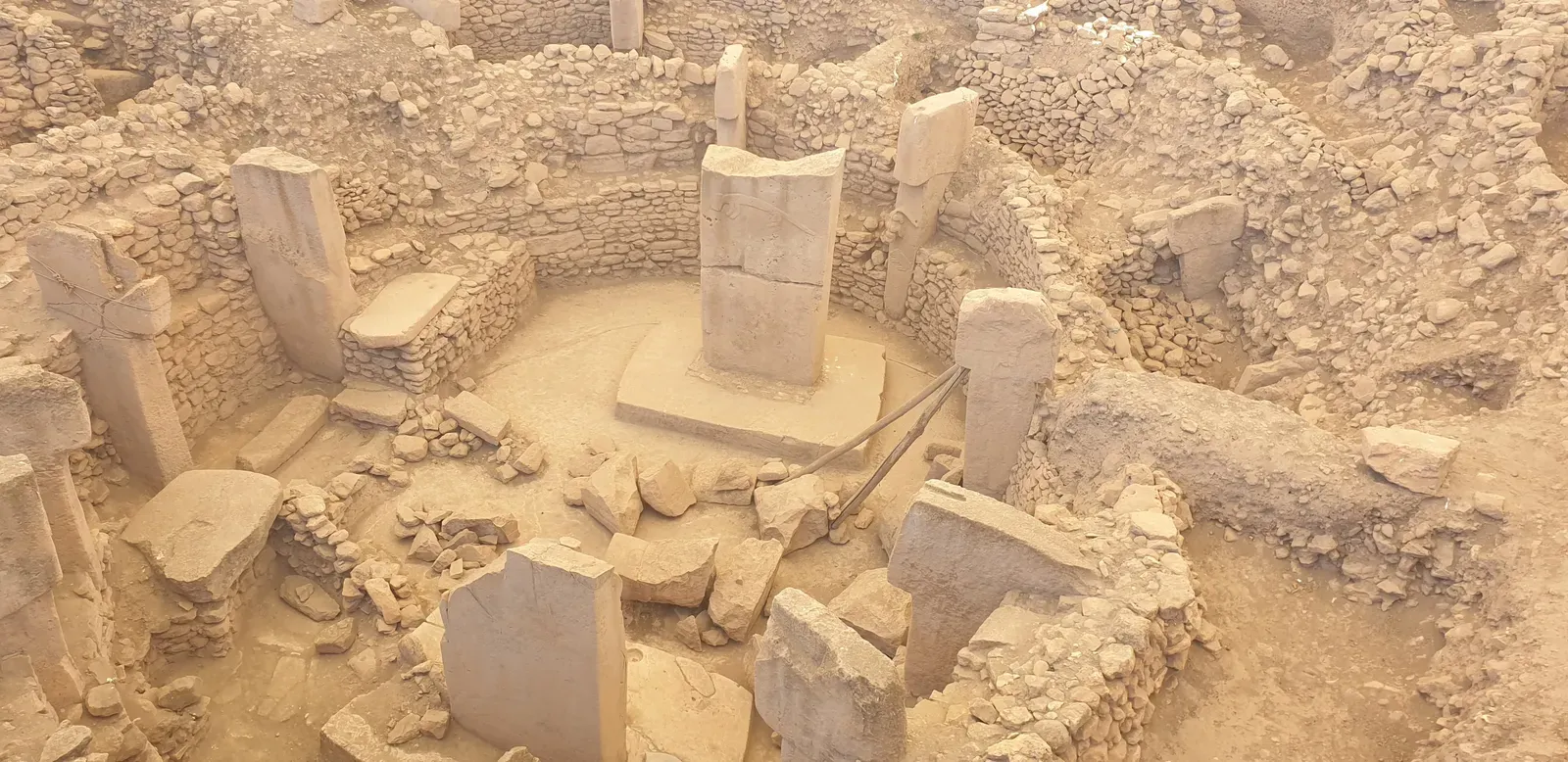
Göbekli Tepe, in southeastern Turkey, rewrote timelines the day it was announced. Older than Stonehenge by thousands of years, this hilltop complex of carved stone pillars shows that organized, large-scale construction began long before the rise of settled farming communities in many regions. The circular enclosures, decorated with animals and abstract symbols, are aligned in ways that some researchers link to specific star patterns and seasonal events. Even if not every proposed star map holds up, the overall layout hints at sustained attention to cycles in nature: migration, climate, light, and darkness. Building such a site required not only labor and artistry, but also planning horizons that stretched beyond a single individual’s lifetime.
What makes Göbekli Tepe especially important for the story of is its place at the dawn of complex society. It suggests that structured observation of the environment – essentially early scientific thinking – was a driver of cultural transformation, not just a by-product. The carvings might represent encoded memories of rare sky events or climatic shifts, serving as a kind of durable data archive in stone. Over time, as new communities moved in and out, much of this symbolic system was buried, both literally and culturally. Modern excavations are effectively decoding a forgotten experiment in how humans first tried to measure, predict, and perhaps influence a world that often felt unpredictable and dangerous.
Ancient Indian Stepwells: Thermal Physics and Water Mathematics
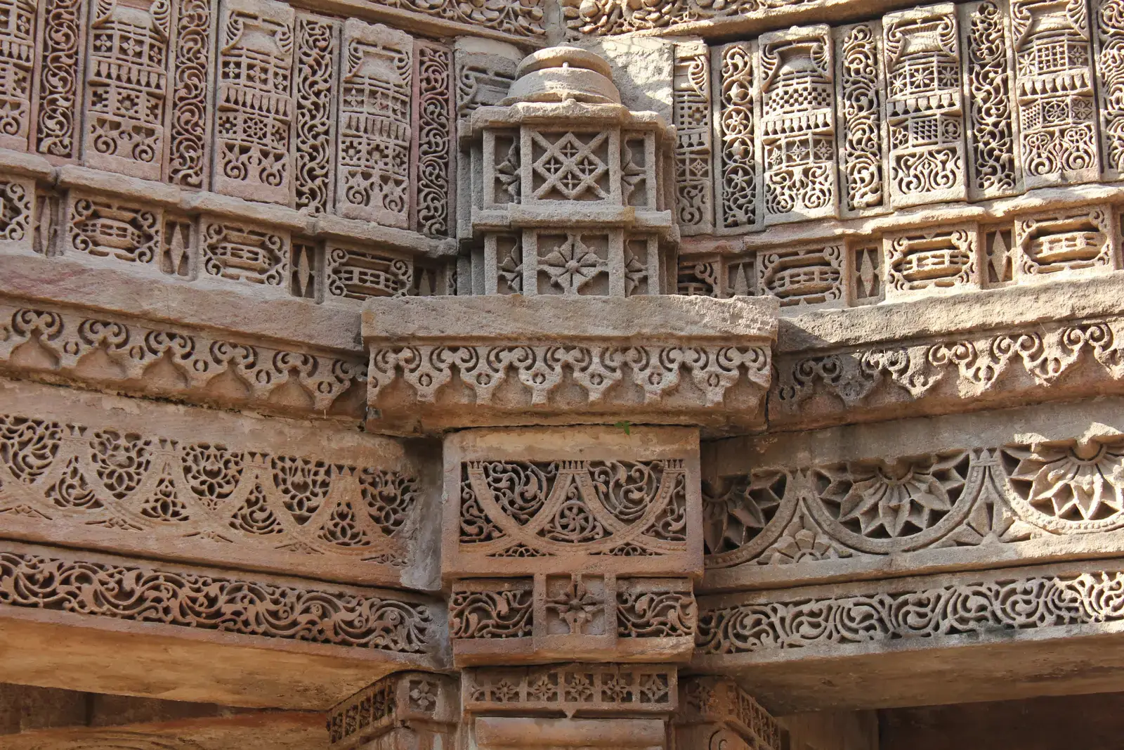
Scattered across western India, stepwells look at first glance like inverted temples: elaborate staircases descending into the earth toward a central pool. Behind their beauty lies highly tuned environmental engineering. These structures capture and store monsoon water in deep, shaded shafts, dramatically slowing evaporation in hot, dry seasons. The multiple levels allow access as water levels rise and fall, turning unpredictable rainfall into a managed resource. Anyone walking down the steps also experiences a noticeable drop in temperature, the product of evaporative cooling and the thermal inertia of surrounding stone.
From a scientific perspective, stepwells show an intuitive grasp of groundwater dynamics, heat transfer, and seasonal variability. Builders had to estimate catchment areas, infiltration rates, and the relationship between well depth and aquifers without the equations that modern hydrologists use. Decorative elements were not purely aesthetic; openwork stone screens modulated airflow and light, fine-tuning the microclimate. As colonial-era and then modern piped water systems spread, many stepwells fell into disuse and disrepair, and much of the practical knowledge associated with their design faded. Now, as climate change brings more erratic rainfall, urban planners and climate scientists are looking back at these ancient systems as blueprints for low-energy, decentralized water management in arid and semi-arid regions.
Nasca Lines and Andean Ceque Systems: Mapping Landscapes with Invisible Geometry
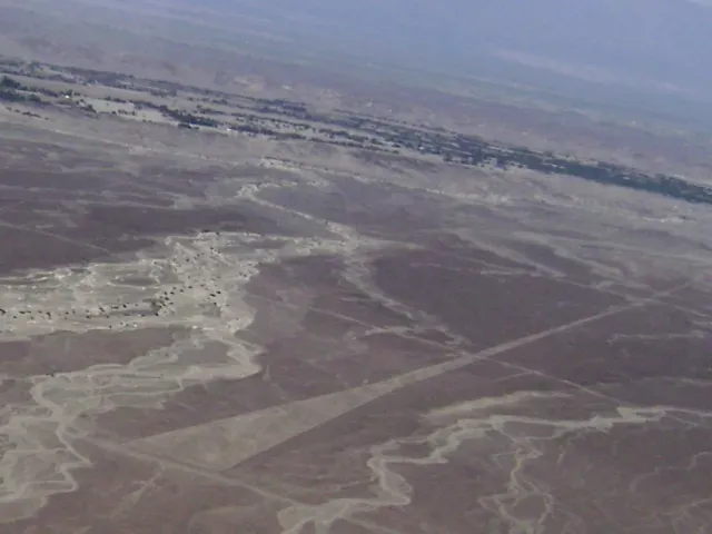
The Nasca Lines in Peru are among the most visually striking puzzles in archaeology: vast geoglyphs etched into the desert floor, depicting animals, plants, and abstract shapes visible best from the air. For decades they were treated mostly as mysterious art or ritual markings, but surveys have revealed a more systematic structure. Many of the straight lines align with horizon points of the sun and other celestial bodies on key calendar dates, suggesting they functioned in part as giant sightlines or processional routes marking solar and perhaps hydrological cycles. The placement often coincides with underground water sources, hinting at a link between sky observation and groundwater mapping. When you view them not as random drawings, but as data drawn across kilometers of desert, the picture changes dramatically.
Further north in the Andean highlands, the Inca ceque system mapped lines of shrines and landmarks radiating out from Cusco, the imperial capital. These imaginary lines organized not only ritual life but also administrative and territorial control, effectively turning geography into a structured information grid. Both the Nasca and Inca systems rely on invisible geometry imposed on the land, transforming mountains, rivers, and plains into reference points in a mental coordinate system. This is survey science without modern instruments, using sightlines, memory, and social practice to encode complex spatial knowledge. Much of this cognitive mapping tradition eroded under colonial disruption, but its traces remain in Indigenous place names, local pilgrimage routes, and the alignment of surviving shrines.
Why These Ruins Matter: The Fragility of Scientific Memory
The idea of “” can sound sensational, but these nine sites illustrate a quieter, more sobering reality: scientific understanding is not a one-way ladder that only goes up. Cultures can develop precise techniques for navigation, water management, structural design, or sky observation, then lose them through war, migration, disease, or shifts in belief systems. Unlike written formulas in a textbook, much traditional science is embodied in practice – how to cut stone, where to place a foundation, when to plant according to star positions. Once the practicing communities disappear or are disrupted, the knowledge can evaporate within a few generations. That makes ruins and landscapes some of the only remaining “pages” of a much larger, missing library.
Comparing these ancient systems with modern science also reveals something uncomfortable: we tend to privilege knowledge that comes with equations and lab equipment, and overlook empirically tested methods that arose from hands-on observation. While today we use satellite-based remote sensing and computer modeling, many of these ancient builders achieved robust solutions using only the human senses, careful record keeping, and social memory. This does not make their knowledge mystical, but it does make it vulnerable. Recognizing the scientific content embedded in sacred sites, city plans, or irrigation networks forces us to rethink how we define expertise. It also raises a pressing question for our own age: which parts of our hard-won climate, medical, or engineering knowledge might future generations see only as puzzling remnants, half-decoded from buildings and data centers we leave behind?
The Future Outlook: New Tools, Old Stones, and Global Implications
In the last decade, a wave of new technologies has transformed how researchers study ancient structures, and it is accelerating. Aerial LiDAR scanning is stripping away forest cover in digital models, revealing hidden city grids and ceremonial complexes beneath jungles in Central America and Southeast Asia. Ground-penetrating radar and muon tomography are peering inside pyramids and mounds without excavation, discovering voids, tunnels, and unexpected structural features. These methods allow scientists to test hypotheses about alignment, load-paths, and water flow at a scale that would have been impossible a generation ago. In effect, we are finally giving these ancient works the kind of forensic analysis usually reserved for modern infrastructure.
The implications go far beyond academic curiosity. As climate change intensifies storms, droughts, and heat waves, engineers are increasingly interested in time-tested low-energy solutions: terracing techniques, passive cooling, decentralized water systems, and materials that weather centuries without high-maintenance inputs. Lessons gleaned from Machu Picchu’s terraces, Indian stepwells, or Andean hydrological mapping could influence next-generation adaptation strategies, especially in regions already facing resource stress. At the same time, there are ethical challenges: how do we incorporate Indigenous and ancestral knowledge without exploiting or oversimplifying it? International collaborations that involve local communities, historians, and scientists will be crucial if we want to turn these ruins into shared laboratories for a more resilient future.
What You Can Do: Seeing Ruins as Living Laboratories
Engaging with this story of does not require a PhD or an excavation permit; it starts with how you see old stones and familiar landmarks. When you visit a historic site, try asking not only what gods were worshipped there, but also what environmental or practical problems its builders were solving. Look for signs of water management, climate control, orientation, and materials choice, and read site reports or museum panels with an eye for the underlying experiments in nature. Supporting public science communication – through museums, documentaries, or reputable online platforms – helps keep funding and attention flowing toward interdisciplinary fieldwork. Even small choices, like choosing tours that involve local guides trained in both cultural and scientific aspects, can shift demand toward deeper, more respectful storytelling.
If you cannot travel, there are still meaningful ways to engage. Open-access archaeological databases, virtual reconstructions, and citizen-science projects invite volunteers to help classify satellite images or transcribe old field notes. Donating to heritage preservation groups that work with, rather than over, local communities helps protect fragile sites and the living knowledge that surrounds them. Most importantly, staying curious – and skeptical of simplistic claims about hyper-advanced mystery civilizations – creates space for the more interesting, nuanced truth. Humanity has always been experimenting, observing, and sometimes forgetting what it learns. The next time you see a photograph of an ancient structure, you might ask yourself: what experiment were they running, and what might we be about to rediscover?

Suhail Ahmed is a passionate digital professional and nature enthusiast with over 8 years of experience in content strategy, SEO, web development, and digital operations. Alongside his freelance journey, Suhail actively contributes to nature and wildlife platforms like Discover Wildlife, where he channels his curiosity for the planet into engaging, educational storytelling.
With a strong background in managing digital ecosystems — from ecommerce stores and WordPress websites to social media and automation — Suhail merges technical precision with creative insight. His content reflects a rare balance: SEO-friendly yet deeply human, data-informed yet emotionally resonant.
Driven by a love for discovery and storytelling, Suhail believes in using digital platforms to amplify causes that matter — especially those protecting Earth’s biodiversity and inspiring sustainable living. Whether he’s managing online projects or crafting wildlife content, his goal remains the same: to inform, inspire, and leave a positive digital footprint.