Imagine stepping outside your door and seeing pillars of light stretching into the sky, or witnessing rain that falls red as blood. Picture a tornado made entirely of fire, or clouds that resemble flying saucers so perfectly they’ve been mistaken for UFO sightings. These aren’t scenes from your favorite science fiction movie.
They’re real weather phenomena happening right here on Earth, so rare and extraordinary that they challenge everything you thought you knew about meteorology. While you check the forecast for simple rain or sunshine, Mother Nature occasionally shows off with displays so spectacular they seem impossible. Let’s dive into eight of these mind-bending weather events that prove our planet is far stranger than fiction.
Fire Tornadoes: When Hell Literally Meets Earth
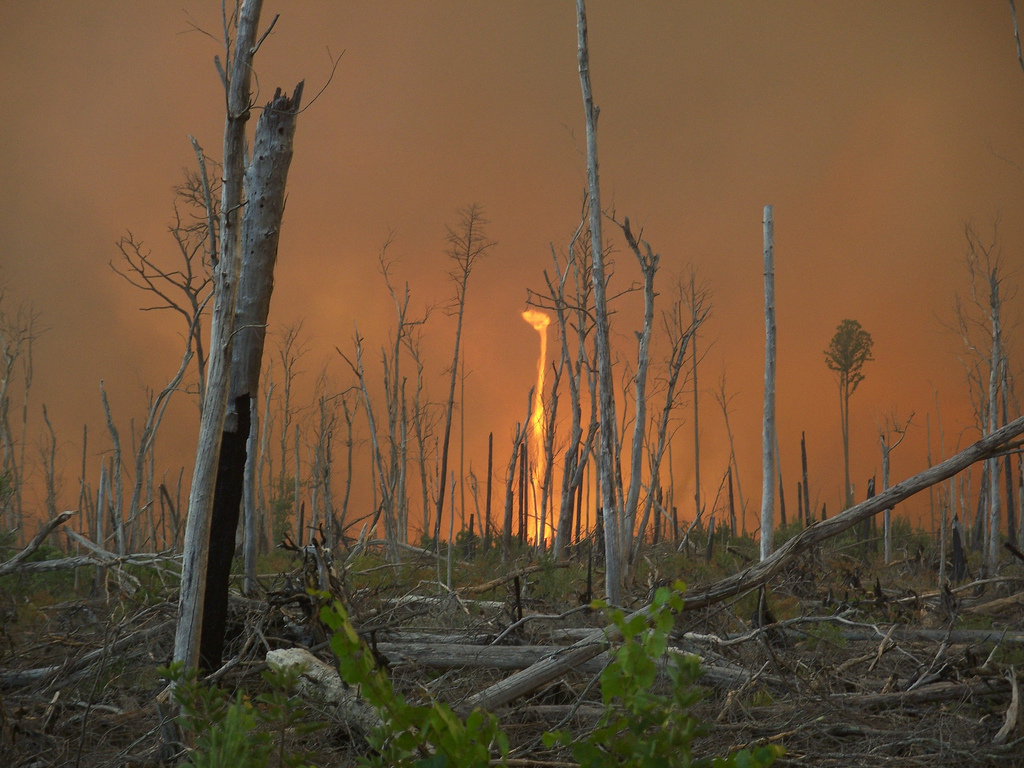
You’ve probably seen regular tornadoes in disaster movies, but nothing can prepare you for the first time you witness a spinning vortex of air that picks up flames, ash, and debris. Fire tornadoes are rare atmospheric tornado events, and they’re exactly as terrifying as they sound. A fire whirl can reach up to 2,000 °F (1,090 °C), turning the landscape into something that looks more like an alien planet than anywhere on Earth.
These fiery monsters form when wildfires produce a lot of heat, which causes the air above them to rise rapidly, and cooler air from the surrounding area rushes in to replace it. A fire tornado can stretch hundreds of feet into the sky and have winds that spin at speeds over 100 miles per hour. The devastating 2018 Carr Fire tornado would hit Redding, California, creating one of the most documented examples of this phenomenon.
Think of it like nature’s blowtorch gone rogue. Fire tornadoes are extremely dangerous and can spread embers far beyond the main wildfire, starting new fires in areas that might otherwise have been safe. What makes them particularly frightening is their unpredictability, as their intense heat and chaotic movement make firefighting efforts even more difficult.
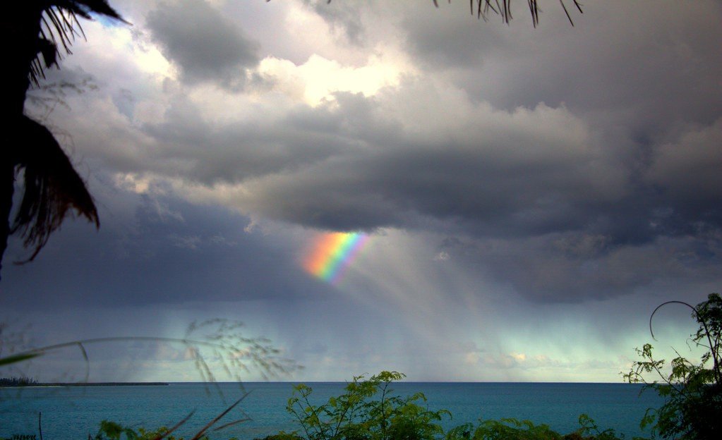
Blood Rain: When the Sky Weeps Crimson

The phrase “raining cats and dogs” sounds normal compared to what happened in Kerala, India, where the blood rain deposited red particulate matter that gave it the distinctive color. The rain was blood red, with some reports saying there was also black, green, and even yellow rain. If you think this sounds like something straight out of a horror movie, you’re not alone.
Before you start panicking about actual blood falling from the sky, scientists have found a more mundane explanation. Researchers have found that this unusual form of rain is stained either by dust from deserts or by microscopic algae that are suspended in the raindrops. However, scientists are not entirely sure how algae get into the clouds, which keeps this phenomenon deliciously mysterious.
Though this may sound like something out of science fiction, there are recorded cases of blood rain from all over the world. From November to December 2012, residents of Sri Lanka got a unique rainstorm – blood rain. Although the rain wasn’t always red (it was also reported to be green, yellow, and black), it was a shock nonetheless. Blood rain has been recorded in Kerala, India multiple times, with notable cases in 1896 and a well-documented event in 2001.
Light Pillars: Earth’s Own Laser Light Show
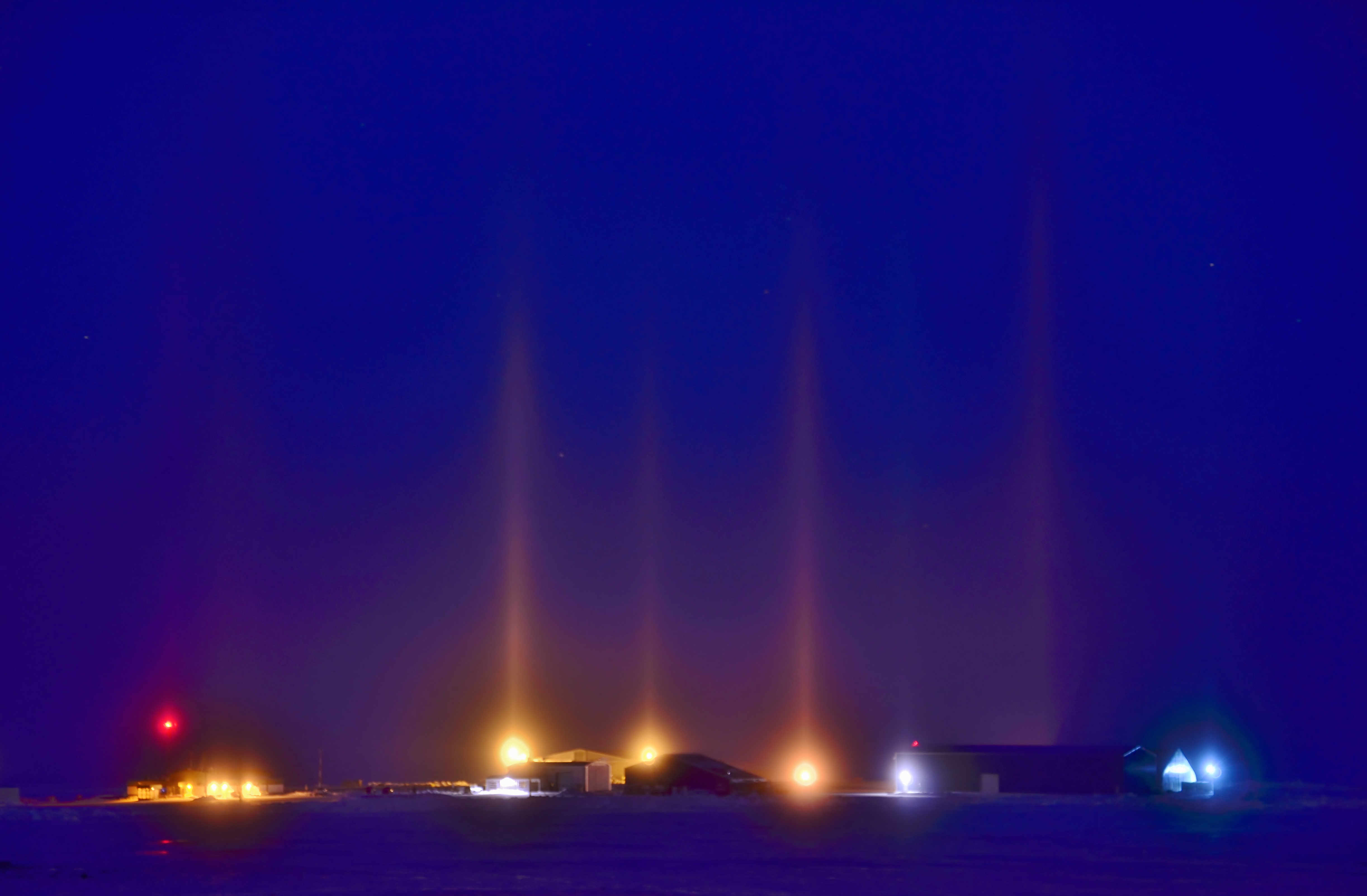
Picture stepping outside on a frigid winter night and seeing mysterious beams of light stretching up into the sky. Light pillars, a captivating atmospheric optical phenomenon, have been observed during extremely cold weather conditions. These mesmerizing columns of light appear to beam directly upwards from unshielded lights, creating a spectacle that captures the imagination.
These aren’t supernatural visitations or alien communications. Light pillars are actually a result of plate-shaped ice crystals suspended in the air close to the ground. For ice crystals to form, the conditions need to be extremely calm and cold, without wind. For the light pillars to show, the ice crystals need to be near the ground. Typically, ice crystals are small enough to remain suspended in the air and only form when temperatures are below zero.
Many such false UFO sightings have been reported, particularly near Niagara Falls, where the mist around the falls often leads to the formation of ice crystals closer to the ground. These ice crystals reflect off the city lights, creating prominent light pillars that mesmerize observers for miles around. The effect is so convincing that they are so rarely seen in the U.S. that they have even been reported as UFO sightings.
Ball Lightning: Nature’s Floating Orbs of Mystery
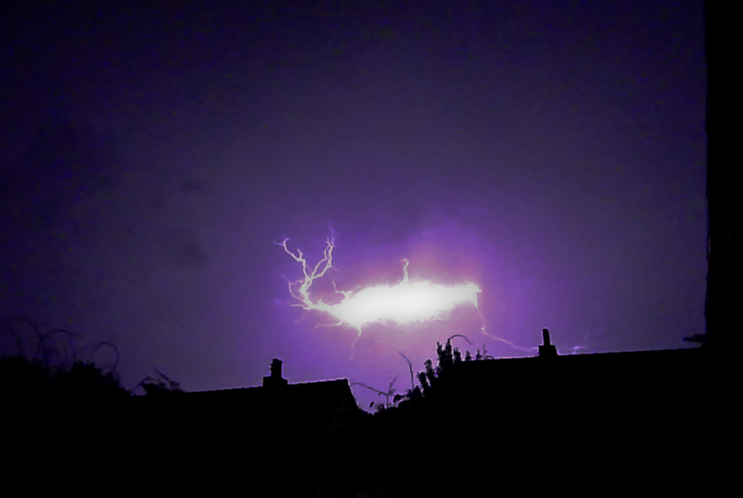
Imagine during a thunderstorm, instead of the usual lightning strikes, you see a floating, glowing orb moving through the air. This rare weather phenomenon, known as ball lightning, has puzzled us for centuries. Unlike the quick flash of regular lightning, ball lightning appears as a sphere of light that can last several seconds, moving through the sky or even entering homes through windows and doors.
People who have seen ball lightning describe it as a sphere that glows in different colors, ranging from blue to orange, with a size that can vary from a small marble to a few feet in diameter. These glowing orbs can float in the air, hover, or zip around before vanishing suddenly, sometimes with a loud bang. That’s ball lightning, a mysterious and rare weather phenomenon that has puzzled scientists for years. These glowing orbs, typically the size of a grapefruit, can last several seconds as they drift erratically in the air.
The scientific community still struggles to fully understand this phenomenon. The nature of these sightings makes ball lightning one of the most fascinating weather phenomena we encounter. What makes ball lightning particularly intriguing is its unpredictability and the fact that it seems to defy many of our conventional understanding of electrical phenomena.
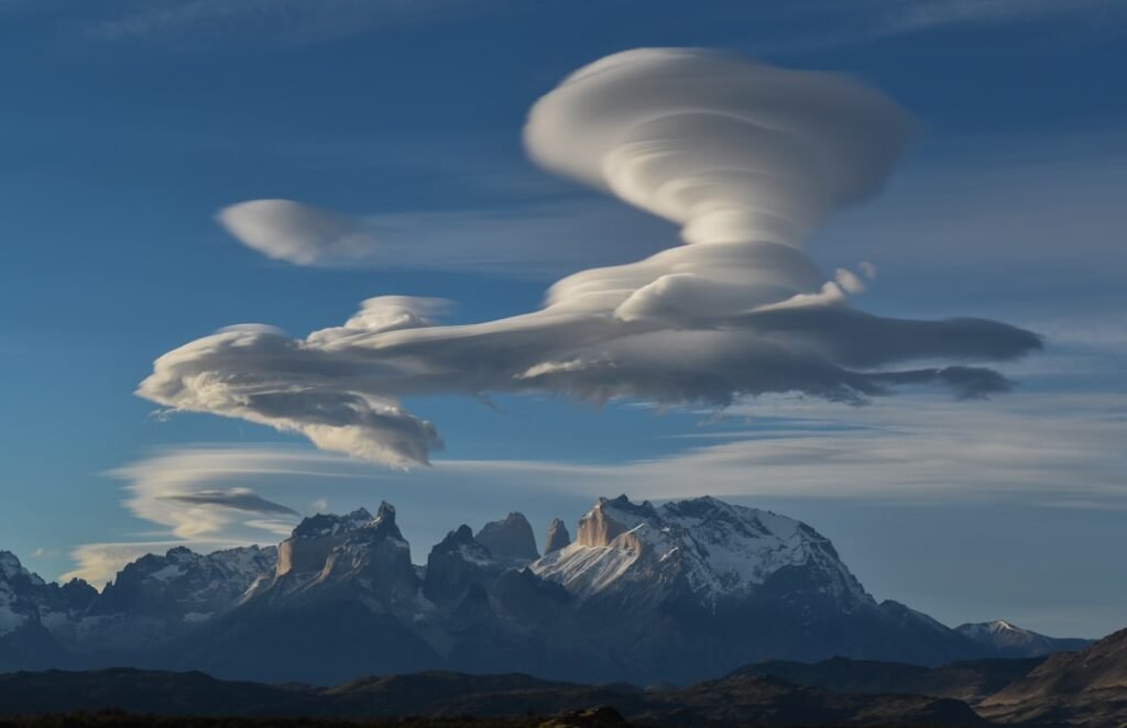
Lenticular Clouds: Nature’s Flying Saucers

We all know that flying saucers are the stuff of science fiction – don’t we? But you can see why UFO reports arise from the ‘out of this world’ weather phenomena of lenticular clouds. These smooth, lens-shaped clouds look so much like classic depictions of UFOs that they’ve been responsible for countless alien spacecraft reports over the decades.
People are often fascinated by lenticular clouds for a few reasons. Their unusual shape can make the sky look like a scene from a science fiction movie, sparking stories about UFOs and otherworldly visitors. These clouds form when stable, moist air flows over a mountain or large hill, creating a wave pattern in the atmosphere that looks eerily artificial.
The perfect symmetry and smooth edges of lenticular clouds make them appear manufactured rather than natural. They often stack on top of each other in formation, hovering motionlessly in the sky like a fleet of alien vessels. Unlike regular clouds that drift and change shape, lenticular clouds maintain their disc-like appearance for extended periods, adding to their otherworldly mystique.
Green Flash: The Sun’s Final Magic Trick
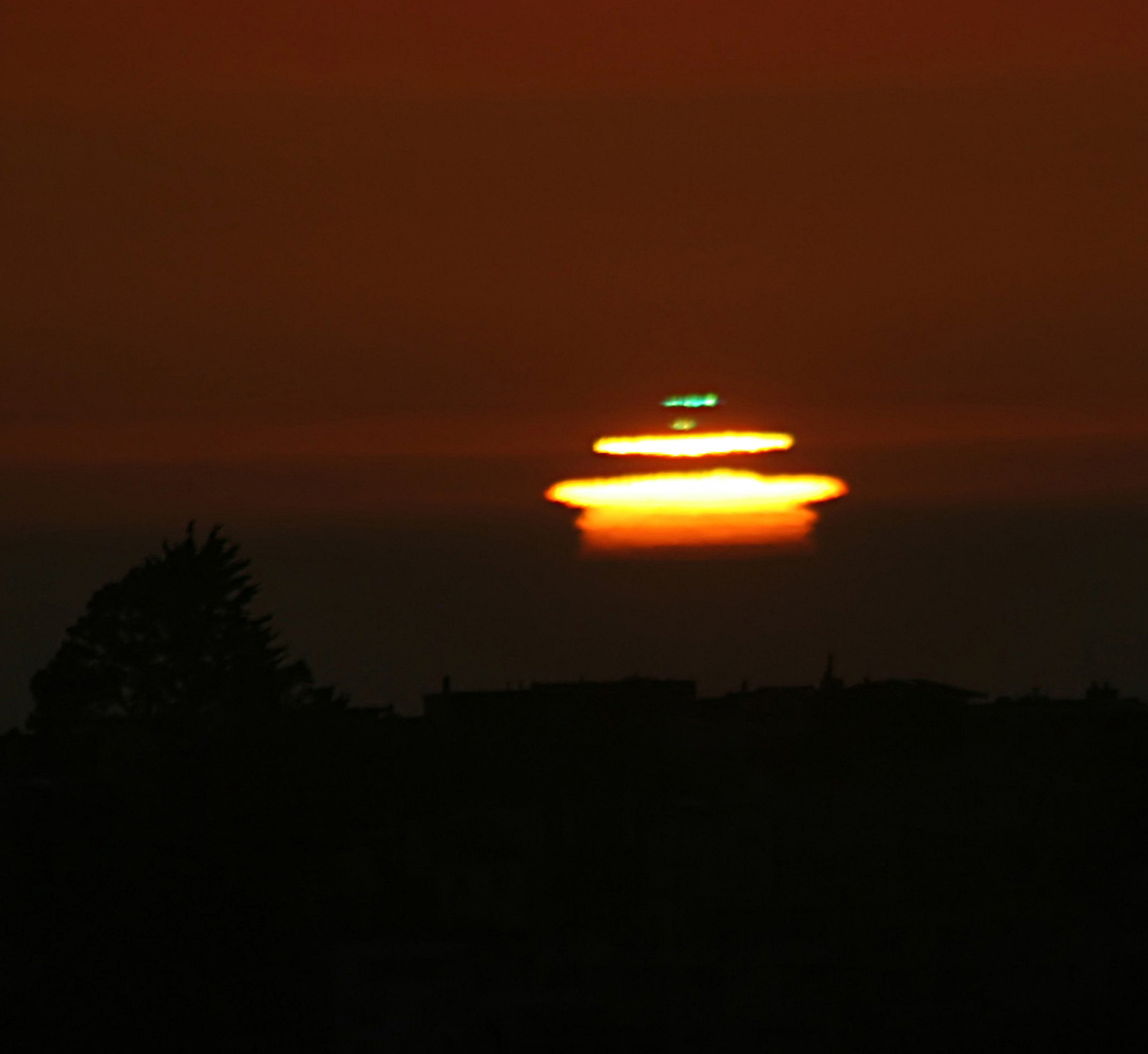
Also known as the green ray, these sporadic events take place briefly just before sunset and sunrise, and can only be seen on a clear day, and when looking at a distant horizon, most commonly over the ocean. As the name implies, a green flash of light appears near the sun. For most people, this phenomenon exists only in pirate legends and fantasy movies.
The science behind this optical illusion is actually quite fascinating. Observing the green flash is the result of looking at the sun through a greater and greater thickness of the atmosphere as the sun moves lower in the sky. Water vapor in the atmosphere absorbs the yellow and orange colors in white sunlight, and air molecules scatter the violet light. As water vapor absorbs the yellow and orange colors (with air molecules scattering the higher purples and violet-blues), all that’s left on the visual spectrum is a flash of green.
This rare phenomenon lasts only a few seconds at most, making it incredibly difficult to capture or witness. The conditions must be perfect: a clear horizon, minimal atmospheric disturbance, and precise timing. Many experienced sailors and photographers spend years trying to catch a single glimpse of this emerald farewell from the setting sun.
Morning Glory Clouds: Australia’s Rolling Thunder
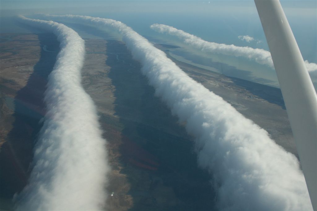
A giant tube-shaped cloud rolls across the sky, stretching from one horizon to the other. This isn’t a scene from a movie – it’s a real weather phenomenon known as the Morning Glory cloud. This rare type of roll cloud creates a stunning visual spectacle that captures the attention of both scientists and thrill-seekers.
What makes the Morning Glory cloud stand out is its unique structure – a long, tube-like cloud that seems to roll smoothly across the sky. One of the best places in the world to witness the Morning Glory cloud is in Northern Australia, particularly over the Gulf of Carpentaria. Here, under the right conditions, these clouds can appear in the early morning, providing a breathtaking view to those lucky enough to see it.
These remarkable formations can stretch for hundreds of miles and move at speeds of up to 12 miles per hour. What makes them even more extraordinary is that glider pilots actually surf these clouds, riding the updrafts created by their rolling motion. The Morning Glory is so predictable in certain parts of Australia that it has become a tourist attraction, with photographers and adventure seekers traveling from around the world to witness this meteorological marvel.
Sprites, Elves, and Blue Jets: Lightning’s High-Altitude Cousins
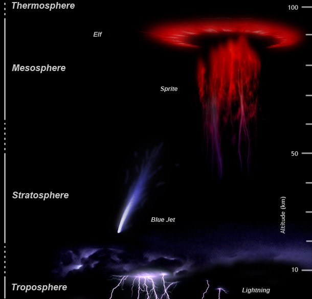
Unlike what we would regard as ‘normal’ lighting, Sprites occur way up in the Earth’s atmosphere at about 50 to 90 kilometres above us, so images of them are rarely captured. Sprites are a kind of cold plasma discharge that occurs above a thundercloud as nature’s way of balancing out the positive lightning charges are released between the thundercloud and the ground below.
In the sky above thunderstorms, a spectacular show occurs, but it’s fleeting and often goes unnoticed. High-altitude lightning phenomena like sprites, elves, and blue jets light up the atmosphere with their unique forms. These electrical phenomena occur far above regular thunderstorms, creating brief but spectacular light shows that most people never see.
Sprites appear as reddish-orange flashes that can be massive, sometimes spanning 30 miles horizontally and reaching 50 miles into the atmosphere. Blue jets shoot upward from thunderclouds in blue cones of light, while elves create brief, expanding rings of light. The spread of artificial lights at night is making it more difficult to see and study faint objects such as sprites. These phenomena were only officially discovered in the late 20th century, despite occurring throughout human history.
Conclusion
These eight extraordinary weather phenomena remind us that our planet still holds countless mysteries, even in an age where we think we understand everything about our atmosphere. From fire tornadoes that seem pulled from apocalyptic nightmares to blood rain that would make ancient civilizations tremble, nature continues to surprise us with displays that challenge the boundaries between reality and fantasy.
What’s perhaps most remarkable is that many of these phenomena are becoming more documented thanks to modern technology and climate change creating new conditions for rare events. Each sighting adds another piece to the puzzle of understanding our complex atmospheric system. Next time you step outside and see ordinary clouds or regular rain, remember that somewhere on Earth, someone might be witnessing pillars of light piercing the sky or watching a cloud roll across the horizon like a giant tube. What would you have guessed our planet was capable of creating such spectacular, science fiction-worthy displays?

Hi, I’m Andrew, and I come from India. Experienced content specialist with a passion for writing. My forte includes health and wellness, Travel, Animals, and Nature. A nature nomad, I am obsessed with mountains and love high-altitude trekking. I have been on several Himalayan treks in India including the Everest Base Camp in Nepal, a profound experience.


