Have you ever stood somewhere and felt like the rules of physics were taking a coffee break? Maybe your compass needle spun in circles like it had lost its mind. Maybe your sense of direction just vanished into thin air. These places exist across our planet, scattered like hidden puzzle pieces that scientists still can’t quite fit together.
You might think we’ve mapped every corner of Earth by now. Satellites orbit overhead. GPS tells us where we are down to the meter. Yet there remain spots where our most reliable navigational tools betray us, where magnetic fields twist into knots, and where compasses point nowhere useful at all. Some of these spots are legends whispered among pilots and sailors. Others are geological oddities that researchers debate in academic journals. What unites them is mystery.
Let’s be real, nobody likes feeling lost. That primal unease when your compass refuses to cooperate touches something deep in our survival instincts. Think about early explorers who depended entirely on these instruments. One malfunctioning compass could mean death. Today we have backup systems, but these anomalies still fascinate us because they remind us that Earth keeps secrets. So let’s dive in.
The Oregon Vortex: Where Horses Refuse to Enter
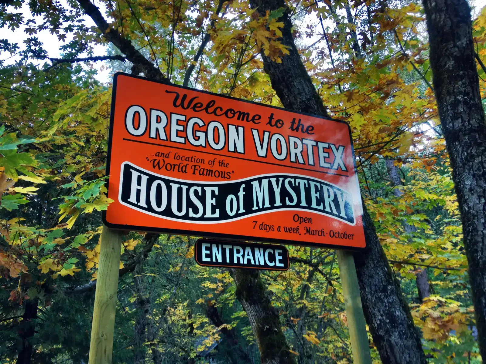
You’ll find this strange circular area near Gold Hill, Oregon, where visual and perceptual phenomena occur naturally and can be captured on film. Local Native American tribes once called this area forbidden ground. Horses reportedly stop and turn around before even reaching the border of where the vortex is said to be, coupled with incorrect compass readings and unexplainable changes in height.
Scottish physicist and geologist John Litster took over the old mining assay in 1920, running experiments in the vortex that produced confusing results which, to him, could only be explained by a supernatural or unknown force. The hills are layered with basalt, iron-rich rock, and quartz, minerals known to interact with magnetic fields, with the land also once holding veins of gold, creating the perfect storm for geomagnetic anomalies. James Randi used photography and mathematics to describe the claims of the Oregon Vortex as optical illusions in 1998. Still, visitors continue to report bizarre experiences that go beyond simple visual tricks.
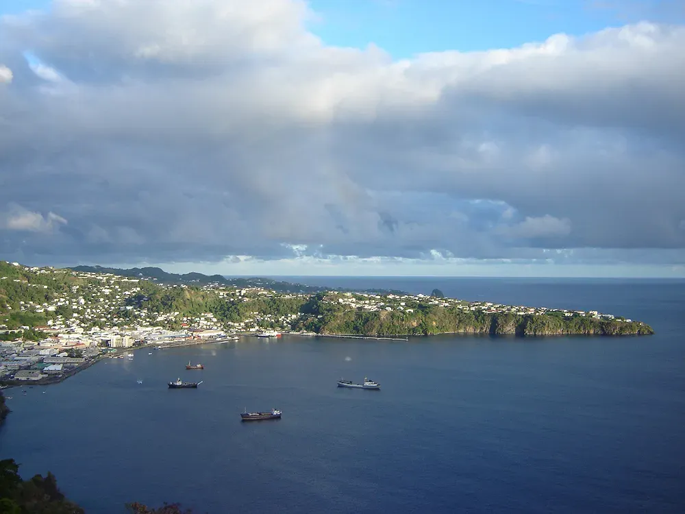
The Bermuda Triangle: More Than Just a Maritime Legend
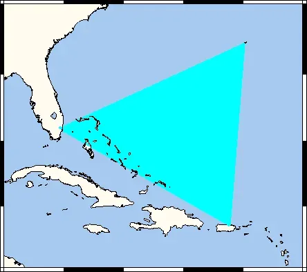
Picture yourself as a pilot in 1945, flying over the Atlantic Ocean between Florida, Bermuda, and Puerto Rico. Your compass starts acting strange. Everything looks wrong somehow. Christopher Columbus looked down at his compass on October 8, 1492, and noticed it was giving weird readings, though he didn’t alert his crew because having a compass that didn’t point to magnetic north may have sent the already on edge crew into a panic.
There is some evidence to suggest that the Bermuda Triangle is a place where a “magnetic” compass sometimes points towards “true” north, as opposed to “magnetic” north. Honestly, this might not sound like a big deal, yet even small navigational errors compound quickly when you’re crossing hundreds of miles of open ocean. It has been theorized that in the Bermuda Triangle, there are abnormal fluctuations in the Earth’s magnetic field that interfere with compass function, although scientists are yet to find concrete evidence of abnormal magnetic field fluctuations in the area. There is no evidence that mysterious disappearances occur with any greater frequency in the Bermuda Triangle than in any other large, well-traveled area of the ocean.
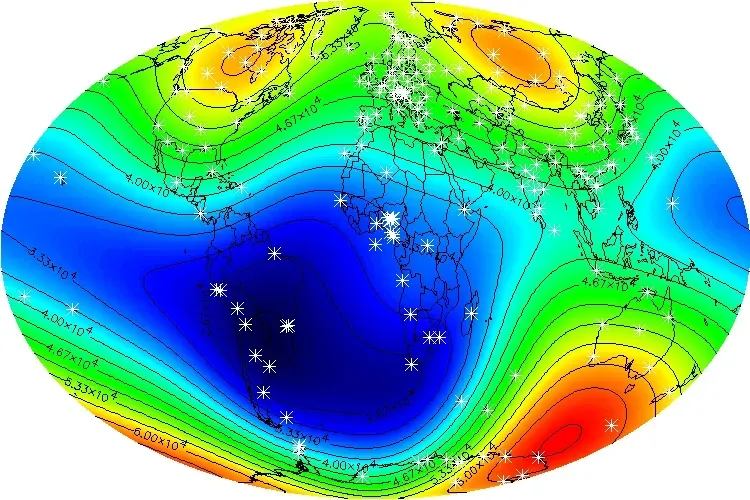
South Atlantic Anomaly: The Bermuda Triangle of Space
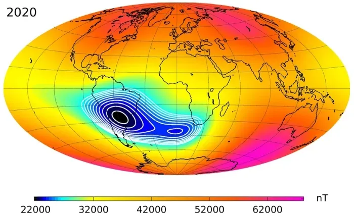
The South Atlantic Anomaly (SAA) is caused by a dent in Earth’s magnetic field where the field is much weaker, allowing dangerous particles to dip closer to the surface. This isn’t folklore or sailor’s superstition. This is hard science with measurable effects.
NASA has reported that modern laptop computers have crashed when Space Shuttle flights passed through the anomaly, and in October 2012, the SpaceX Dragon spacecraft experienced a transient problem while passing through it. Magnetic compasses and other navigation systems that rely on Earth’s magnetic field can experience deviations when operating within the SAMA, leading to incorrect readings and requiring compensatory adjustments to maintain accurate navigation. The really unsettling part? Recent observations show the region is expanding westward and continuing to weaken in intensity, with observational data from 2015-2020 finding the SAA has recently started to split from a single valley into two cells. What does that mean for future navigation? Nobody knows for certain.
Kursk Magnetic Anomaly: Earth’s Largest Magnetic Disturbance
The Kursk Magnetic Anomaly is recognized as the largest magnetic anomaly on Earth, a territory rich in iron ores located within the Kursk, Belgorod, and Voronezh oblasts in Russia. Imagine standing in a region where massive underground iron deposits create their own competing magnetic field powerful enough to be measured from space.
The KMA was first discovered in 1773 by Russian astronomer Pyotr Inokhodtsev while preparing maps, and it was not investigated again until 1874. The peak-to-trough magnetic anomaly measured over 34 nT at an altitude of 350 km. To put that in perspective, that’s an enormous deviation detectable hundreds of kilometers above Earth’s surface. The ores are spread over an area estimated at 120,000 square kilometers with surveyed ore reserves of ferrous quartzite presently estimated at more than 25 billion tonnes. If you were trying to navigate by compass in this region, you’d need to apply significant corrections just to figure out which way is actually north.
Kingston Harbour: Where Compasses Swing 30 Degrees
The Kingston waterfront area is affected by a strong magnetic anomaly caused by mineral deposits in the immediate area. This spot sits at the northeastern end of Lake Ontario where it meets the St. Lawrence River. Mariners know about it. Charts warn about it. Yet the effects remain dramatic.
Along the front of Kingston city, compass variation is not less than 18 degrees in the same direction, at the Government Drydock it is as much as 30 degrees west, and abreast the Penitentiary it is 18 degrees east, with the variation returning to normal a short distance west of Rockwood Asylum. Think about that for a second. You could sail a few hundred meters and watch your compass swing nearly 50 degrees from one extreme to the other. Differences from normal variation of about 6 degrees west to 7 degrees east have been observed at numerous locations throughout Lake Ontario. Experienced captains learn to anticipate these zones, but newcomers often find themselves dangerously off course.
Zone of Silence: Mexico’s Communication Dead Zone
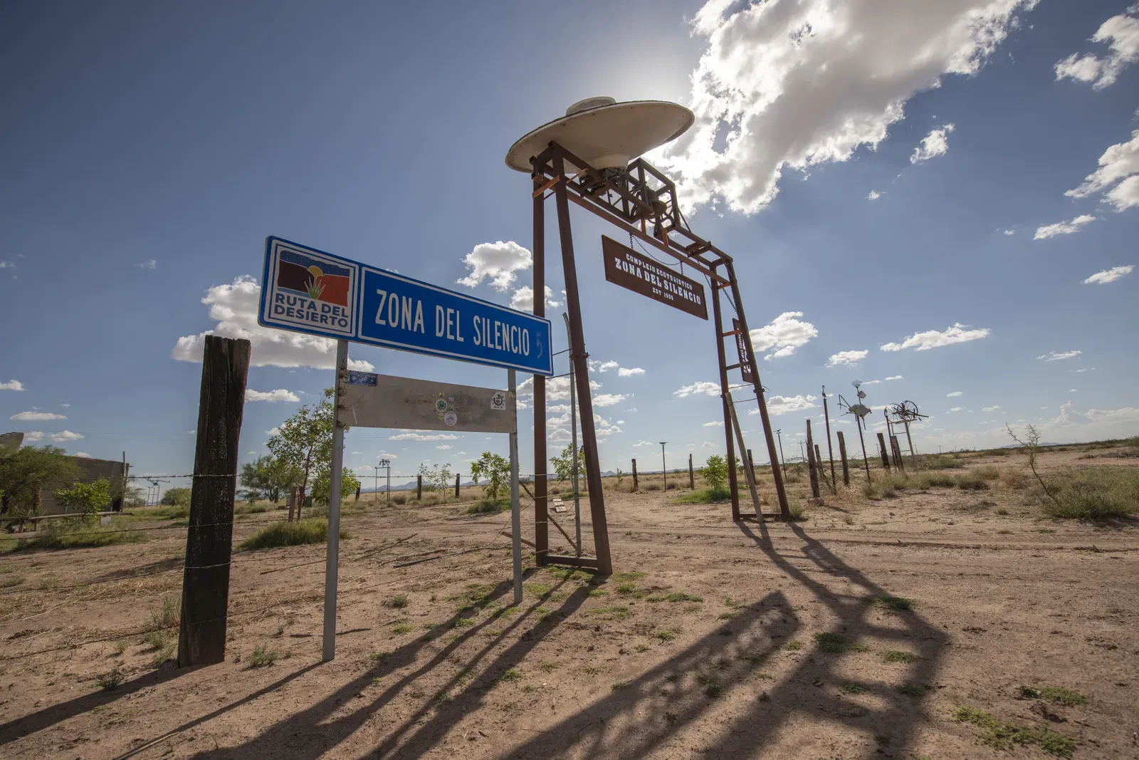
The Zone of Silence in Mexico is an area where radio signals and communications often fail, with compasses spinning uncontrollably and strange lights frequently reported. Located in the Mapimí Desert in northern Mexico, this barren stretch of land has earned a reputation that borders on the supernatural.
What makes this place truly bizarre is the combination of effects. It’s not just magnetic anomalies. Radio waves don’t behave properly either. Some researchers theorize the area sits at the same latitude as the Bermuda Triangle, roughly along the 27th parallel. Others point to high concentrations of magnetite in the soil and rocks. The scientific community remains divided about whether the reported phenomena are genuinely anomalous or simply the result of harsh desert conditions amplified by local folklore. Stories of meteorite crashes in the region add another layer to the mystery. Whatever the cause, pilots and researchers report consistent compass malfunctions in this desolate region.
Hibbing, Minnesota: Where Survey Lines Go Crooked
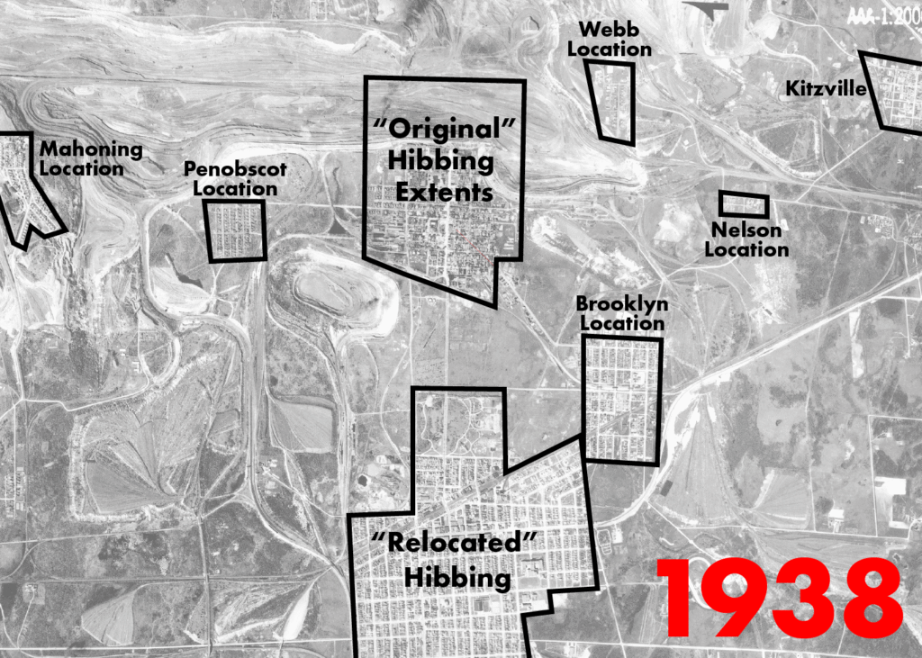
The USPLS survey lines around Hibbing, Minnesota show evidence of problems with magnetic interference from iron ore during survey, and they are often pretty irregular. This might sound like dry technical trivia, yet those survey lines determine property boundaries and legal claims.
The Mesabi Range near Hibbing contains some of the richest iron ore deposits in North America. These massive underground formations create localized magnetic disturbances strong enough to throw off compass readings by several degrees. These anomalies arise from large underground deposits of iron ore or volcanic rock that create their own magnetic fields, pulling the compass needle away from the general magnetic north. Early surveyors didn’t have sophisticated equipment to detect and compensate for these variations. As a result, you can still see the evidence in property maps that zig and zag in ways that make no geometric sense. Modern GPS has solved the practical problem, but it hasn’t eliminated the underlying magnetic chaos.
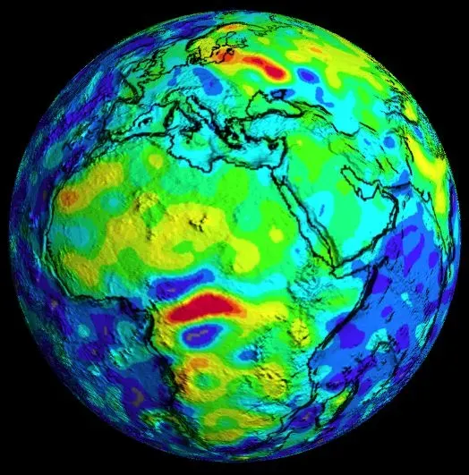
Central African Republic: The Bangui Anomaly
Anomalies associated with ancient structures like the crustal disturbance associated with the Bangui anomaly in west-central Africa are primarily caused by intra-crustal lithologic variations. This massive magnetic feature sprawls across parts of the Central African Republic and remains poorly understood.
Satellite measurements reveal an extensive high-amplitude anomaly that rivals the Kursk anomaly in intensity. The remote and politically unstable nature of the region has prevented detailed ground surveys. What little data exists suggests ancient geological formations deep in Earth’s crust are responsible. These aren’t recent volcanic features or shallow iron deposits. We’re talking about structures formed billions of years ago, now creating magnetic field variations that extend hundreds of kilometers into space. The Bangui anomaly challenges our models of how Earth’s magnetic field should behave over stable continental crust. It’s hard to say for sure, but this anomaly might hold clues about the early formation of continents.
Conclusion
Earth’s magnetic mysteries remind us that we’re still learning about the ground beneath our feet. These eight locations span continents and involve different geological mechanisms, yet they share something profound. They all make our most reliable navigational tools behave like they’ve forgotten their purpose.
Some of these anomalies come from massive iron deposits distorting local magnetic fields. Others involve weaknesses in Earth’s protective magnetic shield. A few might be partially explained by optical illusions working in tandem with subtle magnetic variations. The honest truth is that scientists continue to debate the precise mechanisms behind each location.
Technology has given us GPS, inertial navigation, and satellite mapping. We don’t depend on magnetic compasses the way our ancestors did. Still, these places matter because they reveal gaps in our understanding. They show us that Earth is more dynamic and complex than our models predict. The magnetic field that shields us from solar radiation isn’t a simple dipole. It’s lumpy, shifting, full of local variations we’re only beginning to map in detail.
What would you have guessed causes these anomalies before reading this? Did any of these locations surprise you? Maybe the real mystery isn’t just why compasses go wild in these spots, but why we find ourselves so endlessly fascinated by places where the rules bend just a little bit. Our planet still has secrets worth exploring.

Hi, I’m Andrew, and I come from India. Experienced content specialist with a passion for writing. My forte includes health and wellness, Travel, Animals, and Nature. A nature nomad, I am obsessed with mountains and love high-altitude trekking. I have been on several Himalayan treks in India including the Everest Base Camp in Nepal, a profound experience.