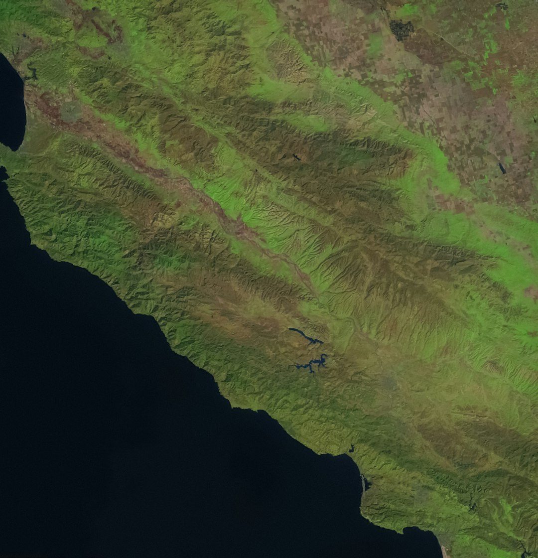
Across North America, there are places where the ground glows, lakes vanish underground, and rocks seem to move on their own. These landscapes look like they belong in myth, yet they sit on real maps, often a day’s drive from crowded cities and familiar highways. Scientists have explanations for some of these sites, but others remain stubbornly strange, teasing researchers with data that does not quite add up. What ties them together is a feeling many visitors describe in the same way: a sense that the planet is quietly doing something just out of sight. These seven locations show how mystery and science can coexist on the same trail, and why these “mystical places” are becoming some of the most important outdoor laboratories in North America.
The Wave That Isn’t Water: Antelope Canyon’s Sculpted Light
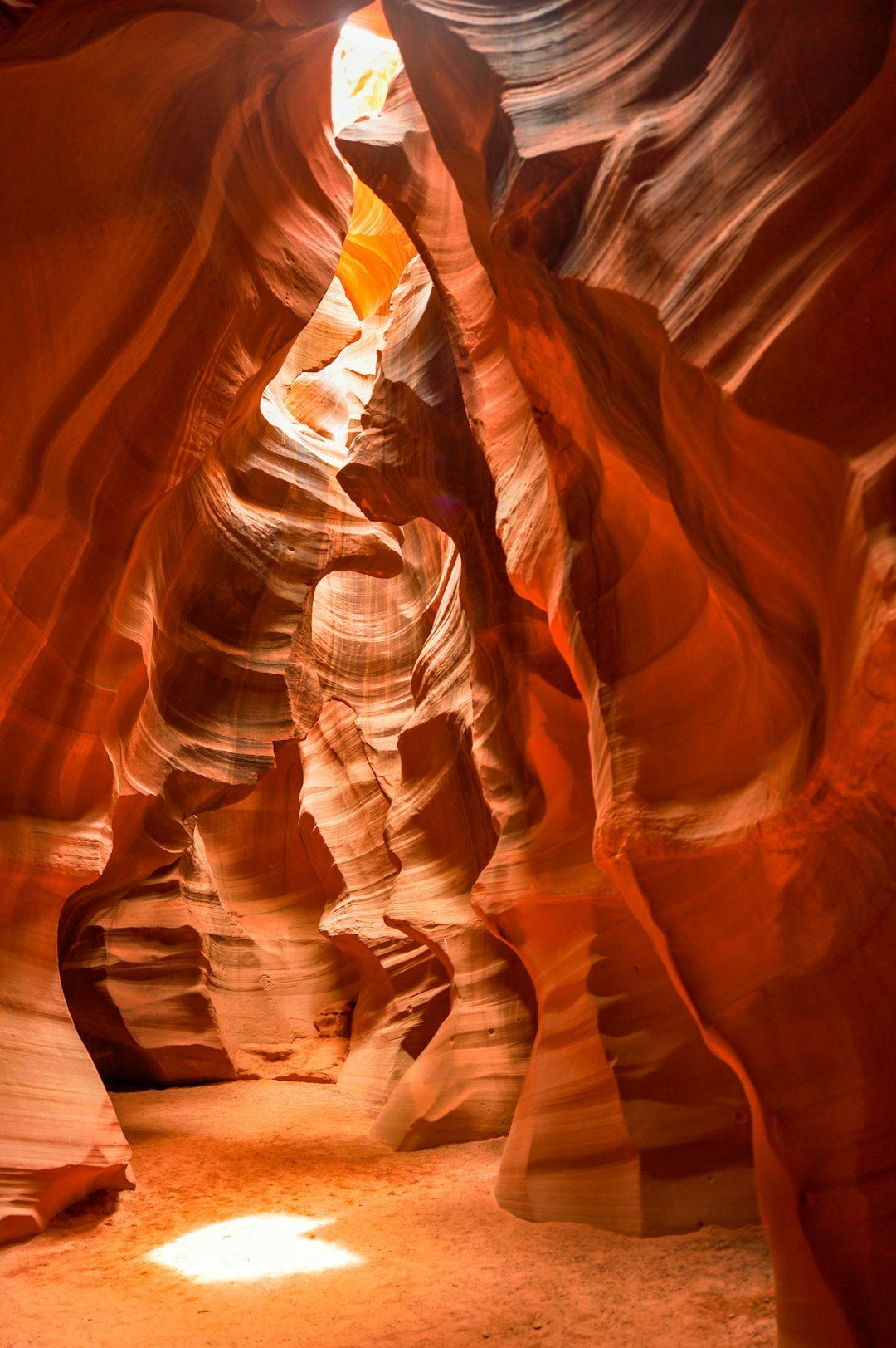
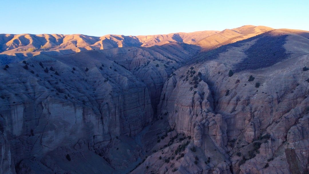
Walk into Antelope Canyon in northern Arizona and it feels like stepping into a liquid made of stone and light. Narrow sandstone corridors twist and curve around you, carved over thousands of years by sudden flash floods roaring through Navajo land. At certain times of day, beams of sunlight slice down through cracks overhead, turning dust and air into something almost solid, like glowing pillars you could lean on. The canyon walls carry delicate horizontal lines, silent evidence of ancient dunes that hardened into rock long before humans arrived. Standing there, it is easy to believe the land is still flowing, even though nothing seems to move.
Geologists see Antelope Canyon as a case study in what violent, episodic water can do in an arid climate. Rather than slow erosion by a steady river, it is sculpted by rare but brutal storms that send walls of muddy water through the slot at frightening speeds. That combination of soft Navajo sandstone and sudden flash floods creates the rounded, wave-like forms that draw photographers from around the world. Local guides also weave in Navajo cultural perspectives, treating the canyon as a sacred space, not just a pretty backdrop. The result is a site where visitors experience both awe and unease, aware that the same forces that shaped this beauty can also be deadly in a matter of minutes.
The Lights That Refuse to Go Out: Marfa’s Desert Orbs
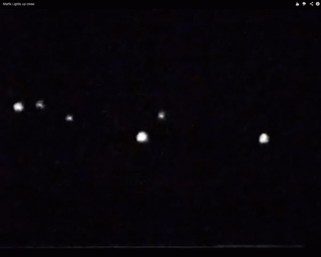
On certain clear nights near Marfa, Texas, small spheres of light appear over the desert, dancing, splitting, and fading without warning. Locals have watched these “Marfa lights” for generations, long before highways, cell towers, and LED signs could be blamed. From a roadside viewing platform east of town, visitors stare toward the horizon hoping to catch a glimpse of something that seems halfway between ghost story and physics experiment. Some lights drift slowly like lanterns, while others flicker in bursts, shifting color from white to reddish hues. The fact that no one can reliably predict when they will appear only deepens the sense of a landscape that refuses to be fully explained.
Researchers have proposed plenty of theories, from car headlights refracted by layers of warm and cool air to piezoelectric effects caused by stress in underground rock. Controlled studies have shown that many reported sightings can indeed be explained by distant traffic and atmospheric mirages, especially on certain temperature gradients. Still, a small portion of accounts do not match those patterns, keeping the mystery alive for scientists who specialize in atmospheric optics. The Marfa region has become an informal field site where observers bring instruments, not just cameras, trying to separate rare natural phenomena from human-made noise. It is a reminder that even in an age of satellites and sensors, a simple desert horizon can still outsmart us.
The Hills That Roll on Their Own: California’s “Mystery Spots” and Gravity Hills
Drive a car onto the right stretch of road in parts of California, Alberta, or Pennsylvania and you might swear gravity has changed its mind. On so-called gravity hills, vehicles left in neutral appear to roll uphill, water seems to flow the wrong way, and tourists film videos that look like physics has taken the day off. One of the most famous clusters of these illusions lies along backroads in Southern California, where drivers line up to test what looks like a natural glitch in the laws of motion. The effect is unsettling because it attacks something we normally trust without thinking: our sense of what is level versus what is sloped.
Scientists and surveyors, armed with precise instruments, have repeatedly shown that these “uphill” stretches are actually downhill, just camouflaged by the surrounding landscape. A tilted horizon line, oddly shaped tree lines, and subtle road banking trick the brain into reading the scene backward, a kind of open-air laboratory for perception. Yet even when you know the explanation, watching a bottle or ball roll “up” the road still feels wrong, as if your eyes and inner ear are staging an argument. Some sites, branded as “mystery spots,” add leaning cabins and distorted rooms that amplify the effect, giving a carnival sheen to a real perceptual puzzle. In a continent obsessed with data and precision, these hills are a rare place where intuition loses – and people are delighted by the defeat.
The Lake That Breathes: Spotted Lake in British Columbia
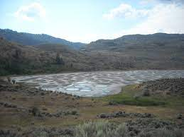
Every summer in British Columbia’s Okanagan region, Spotted Lake shrinks and transforms into a strange mosaic of circular pools, like a painter’s palette left to dry. As the water evaporates, mineral-rich brine separates into distinct spots, each patch varying in color from milky white to deep yellow and green. This happens because the lake holds unusually high concentrations of magnesium sulfate, calcium, and other minerals that crystallize in different ways as the seasons change. The visual result is otherworldly enough to look digitally edited, yet it unfolds slowly and quietly under the same sun that warms nearby vineyards. For many travelers stumbling across photos online, the first reaction is disbelief that it is not a trick.
For the Syilx Okanagan people, Spotted Lake has long been a sacred and medicinal site, visited for its perceived healing properties. Modern geochemists, on the other hand, use it as a window into how mineral-rich basins evolve and how similar features might have formed on Mars or early Earth. The lake is fragile: its chemistry can be disrupted by changes in groundwater, nearby development, or even too many human feet along the shoreline. That is why much of it is now protected and mostly viewed from a distance, balancing curiosity with respect. It sits at a crossroads of traditional knowledge and modern science, reminding us that mystery can be both culturally profound and chemically precise at the same time.
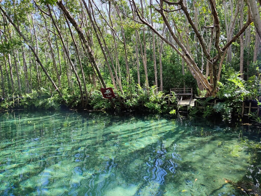
The River That Disappears Underground: Mexico’s Yucatán Cenotes
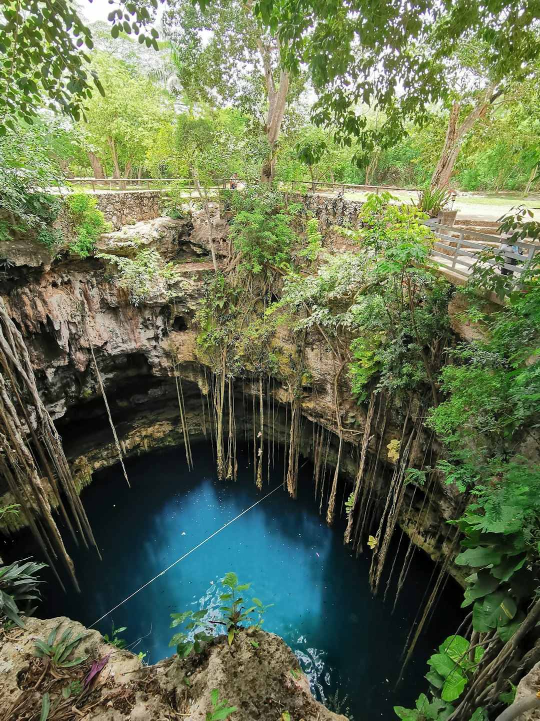
Across Mexico’s Yucatán Peninsula, the jungle floor is punctured by sinkholes filled with clear, blue water that seem to drop straight into the underworld. These cenotes form when limestone bedrock collapses into the vast freshwater caves beneath, revealing a hidden plumbing system that runs for hundreds of miles. Sunlight knifes down through open shafts, catching roots, fish, and sometimes the ghostly outlines of stalactites that once hung in dry air. For the ancient Maya, cenotes were portals to the gods and sites of ceremony; for modern hydrologists, they are access points to one of the most complex karst aquifers on Earth. Standing at the edge of one, you feel both exposed and invited, as if the planet has left a secret door open just long enough to peek inside.
Scientific cave diving expeditions in recent decades have mapped intricate networks linking dozens of cenotes, revealing a sprawling underground river system that delivers water to millions of people. These explorations have turned up archaeological artifacts, extinct animal remains, and climate records locked inside mineral deposits lining the cave walls. At the same time, pollution from tourism, agriculture, and growing cities is beginning to seep into this hidden system, raising alarms among local communities and researchers. Cenotes now serve as early-warning indicators, showing how surface decisions echo underground in ways that are hard to reverse. The mystery here is not whether we can explain the geology, but whether we will act quickly enough to protect a water world we are only starting to fully understand.
Why These Mystical Places Matter More Than Ever
It is tempting to treat sites like these as beautiful oddities, the geological equivalent of roadside attractions, but that view misses their deeper importance. Each “mysterious” landscape is also a natural archive, storing clues about past climates, ancient ecosystems, and the ways Earth responds to stress. For example, the mineral layers in Spotted Lake or the stalagmites in Yucatán caves can record shifts in rainfall and temperature over thousands of years, offering a baseline for today’s rapid changes. The light-bending air above Marfa’s desert can help refine models of how temperature inversions and pollution affect visibility and heat distribution across bigger regions. When scientists read these landscapes carefully, the mystery becomes a tool, not a barrier.
Compared with traditional lab-based studies, fieldwork in these places forces researchers to embrace messier, more interconnected systems. Instead of a single controlled variable, they must consider culture, tourism, local economies, and sacred traditions alongside chemistry and physics. That broader view often leads to more realistic insights about how people and planet shape one another. In a time when many environmental stories are framed as crisis-only, these sites also offer something quieter but powerful: wonder, a feeling that can pull people into caring long before statistics do. Put simply, the planet’s strangest corners are often where our understanding of it moves forward the fastest.
The Future of Studying North America’s Hidden Wonders
In the coming years, scientists will not just visit these sites with notebooks and cameras – they will bring tools that would have looked like science fiction a generation ago. Lightweight drones can now map remote slot canyons and cenotes in three dimensions, tracing every curve and crevice without disturbing fragile surfaces. Portable spectrometers and environmental sensors allow researchers to measure air quality, mineral composition, and microclimates on the spot, rather than hauling samples back to faraway labs. Even satellite constellations are fine-tuned enough to monitor changes in water levels, vegetation, and ground deformation around these sites over time. The more data we gather, the more clearly we can see how quickly these “timeless” landscapes are actually changing.
But new technology brings new challenges, especially the risk of turning delicate places into overcrowded check-in locations on social media. Conservationists and local communities are already wrestling with questions about how many visitors a cenote can safely host, or how much light and noise Antelope Canyon can handle before its character changes. Some regions are exploring permit systems, Indigenous-led stewardship, and remote virtual tours to balance access with protection. If those approaches work, they could serve as models for managing other fragile attractions worldwide, from Icelandic hot springs to Himalayan valleys. The real test will be whether we can treat mystery as something to be protected, not consumed.
How You Can Explore – and Protect – These Mystical Places
For travelers in North America, the most powerful step is deceptively simple: choose to see these places as more than just backdrops for photos. That means learning a bit of their geology and cultural history before you arrive, so you recognize the stories in the rock layers and the traditions tied to the water or light. Visiting with local or Indigenous guides, where available, keeps more money in nearby communities and often reveals perspectives you will not find on a trail sign. It also means accepting limits – staying on marked paths, respecting closures, and skipping that “perfect shot” if it means stepping where you should not. In fragile environments, restraint is its own form of participation.
If you cannot travel, you can still support these hidden wonders from home. Many research teams and conservation groups share their work online, offering ways to donate, join citizen science projects, or amplify calls for protection when development threatens. Paying attention to how groundwater, dark skies, or protected areas are managed in your own region can indirectly help similar sites across the continent. After all, the same forces – climate shifts, pollution, unchecked tourism – that endanger a cenote or desert light phenomenon are at work in quieter corners of your local landscape too. The Earth’s strangest places are not separate from everyday life; they are just where the planet’s secrets are a little easier to see.

Suhail Ahmed is a passionate digital professional and nature enthusiast with over 8 years of experience in content strategy, SEO, web development, and digital operations. Alongside his freelance journey, Suhail actively contributes to nature and wildlife platforms like Discover Wildlife, where he channels his curiosity for the planet into engaging, educational storytelling.
With a strong background in managing digital ecosystems — from ecommerce stores and WordPress websites to social media and automation — Suhail merges technical precision with creative insight. His content reflects a rare balance: SEO-friendly yet deeply human, data-informed yet emotionally resonant.
Driven by a love for discovery and storytelling, Suhail believes in using digital platforms to amplify causes that matter — especially those protecting Earth’s biodiversity and inspiring sustainable living. Whether he’s managing online projects or crafting wildlife content, his goal remains the same: to inform, inspire, and leave a positive digital footprint.