There are places on this planet that look so strange, so impossibly crafted, that they feel more like the backdrop of a science fiction movie than somewhere you could actually visit. Geologists have powerful tools, clever theories, and decades of research behind them, and yet a handful of landscapes still refuse to give up all their secrets. We know some of the “how,” but the “why here, exactly this way?” part still nags like an itch in the back of the scientific mind.
What makes these formations so fascinating isn’t just their beauty, but the gaps in our understanding. Some are tied to deep forces we can’t directly see. Others hint at ancient climates or processes that don’t fully match what we see on Earth today. As you go through these seven places, notice how often the answer is “we know a lot, but not everything.” That little slice of mystery is where curiosity thrives.
The Eye of the Sahara (Richat Structure, Mauritania)
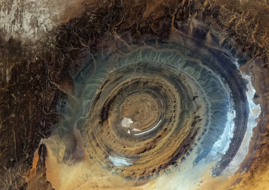
Imagine flying over the Sahara and seeing what looks like a giant bull’s-eye staring back at you from the middle of the desert. That’s the Richat Structure, often called the Eye of the Sahara: a nearly perfect circular formation more than twenty-five miles across that astronauts have used as a landmark from space. At first glance, it looks exactly like the impact crater of an enormous asteroid, and for years that was the leading idea.
Then the evidence decided not to cooperate. Shocked quartz and other typical signs of a massive impact are missing, and the rock layers look more like a deeply eroded dome of uplifted rock than a crater. Many geologists now think it’s a “structural dome” carved out by millions of years of erosion, but the near-perfect ring symmetry and its lonely isolation in the desert still raise uncomfortable questions. Why this tidy pattern here, and not in dozens of other domes around the world?
The Giant’s Causeway (Northern Ireland)
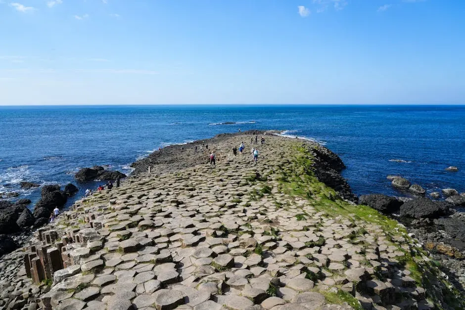
Walk along the shore at the Giant’s Causeway and it almost feels like you’re stepping across the stumps of a forest of stone. Roughly about forty thousand basalt columns, most of them with six sides, fit together like a carefully designed pavement leading into the sea. The columns are so geometric that early visitors insisted there had to be some human or mythical hand involved, and honestly, when you see it up close, that idea doesn’t feel completely ridiculous.
We know the broad strokes: around fifty to sixty million years ago, lava cooled and cracked in a way similar to drying mud, creating polygonal joints. This kind of “columnar jointing” appears in other places, like Devils Postpile in California and basalt flows in Iceland, so it’s not unique to Ireland. What’s still debated are the finer details: why some areas produce mostly six-sided columns, others mix in more four, five, or seven; why the columns can be so tall, uniform, and perfectly arranged in some clusters. The physics of cooling lava is notoriously touchy – small changes in cooling rates, water, or chemistry can wildly change the pattern – and scientists are still working to fully reproduce what nature pulled off here.
Sailing Stones of Racetrack Playa (Death Valley, USA)
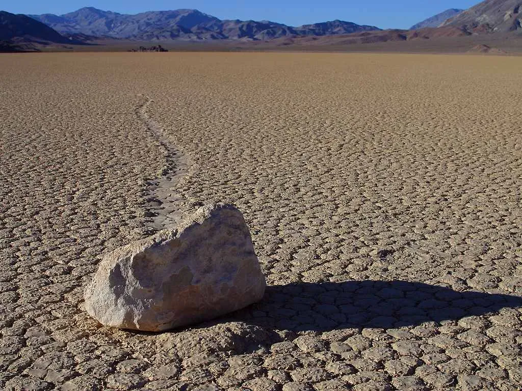
For decades, visitors to Racetrack Playa in California’s Death Valley saw something that looked like a prank pulled by nature itself: heavy rocks scattered across a flat, dry lakebed, each with a long track carved into the mud behind it. No one ever saw the stones move, yet the trails proved they had. Some traveled many dozens of meters in seemingly straight or gently curving paths, including rocks that would take a strong person to even nudge.
We now know the stones do move, very slowly, under an odd combination of thin ice sheets, a shallow layer of meltwater, and light winds. When conditions are just right, the ice floats the stones slightly and the wind drifts the slick ice slabs, dragging the rocks along and etching those eerie trails. Researchers have captured this movement with time-lapse cameras, but there are still nagging puzzles: why some trails are sharply bent while others are arrow-straight, why certain rocks move while nearby ones don’t, and why these perfect conditions line up so rarely here and almost nowhere else. It’s like a physics experiment nature runs only once in a blue moon.
The Blood Falls of Antarctica
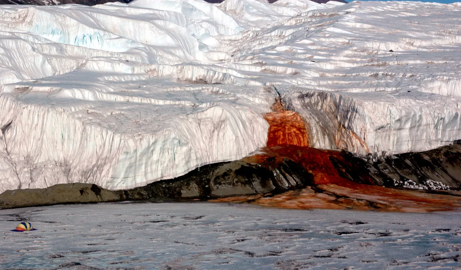
At the edge of Taylor Glacier in Antarctica, a streak of deep, rusty red water pours down onto gleaming white ice, looking uncannily like a glacier that has been cut open and left to bleed. When explorers first saw Blood Falls in the early twentieth century, they had no way to explain why a glacier was oozing what looked like liquid iron. In the coldest, driest part of Antarctica, flowing water itself is already a shock, let alone water this color and chemistry.
Modern research shows the water comes from a salty, iron-rich, oxygen-poor brine trapped under the glacier. As it reaches the surface and meets air, the iron oxidizes and turns red, much like rusting metal, giving the falls their dramatic color. Microbes living in this brine survive without sunlight, feeding on sulfur and iron in conditions similar to some proposed environments on Mars. What still intrigues experts are the details of how this brine system has stayed liquid and isolated for so long, how the plumbing under the glacier is arranged, and what it might be hinting about hidden ecosystems beneath other ice sheets. It’s a reminder that “frozen” doesn’t always mean lifeless.
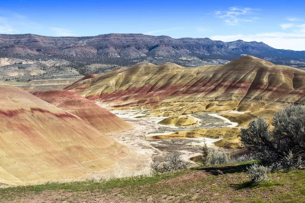
China’s Rainbow Mountains (Zhangye Danxia Landform)
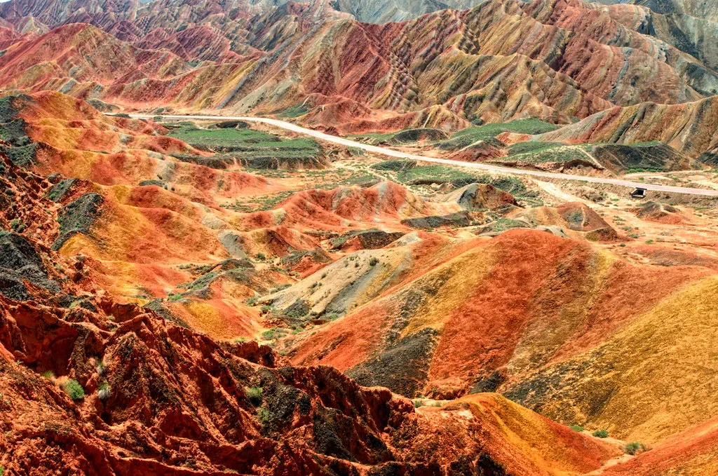
From some viewpoints in China’s Zhangye Danxia National Geological Park, the hills look almost fake, like someone airbrushed stripes of brick red, mustard yellow, and soft blue across the landscape for a fantasy movie backdrop. These “rainbow mountains” are made of layered sandstone and minerals, tilted and warped, then carved by erosion into ridges and valleys painted in surreal, horizontal bands. Photograph them at sunrise or sunset and the colors become almost painfully intense.
The basic explanation is layered sediments laid down over tens of millions of years, each with slightly different minerals and iron contents, later uplifted and eroded. But the sharpness and consistency of some color bands, and the way they persist over large areas, still lead to active research into the exact environmental conditions when these layers were formed. Temperature, water chemistry, volcanic activity, and even ancient climate cycles all may have contributed to the mineral patterns, but scientists are still piecing together how those factors combined to paint such a vivid natural mural. It’s like flipping through chapters of Earth’s history written in stripes rather than words.
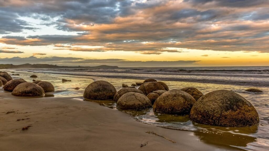
The Moeraki Boulders (New Zealand)
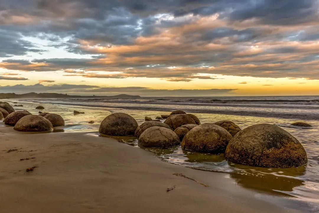
Stroll along Koekohe Beach on New Zealand’s South Island and you’ll suddenly find yourself surrounded by giant stone marbles scattered in the sand. The Moeraki Boulders are almost perfectly spherical in many cases, some as wide as a small car, with strange polygonal cracks running across their surfaces. They look deliberately carved, like props rolled off a movie set, but they formed naturally within ancient marine mudstones.
Geologists classify them as concretions, where minerals like calcite slowly precipitate around a core within sediment, gradually forming a hard lump that resists erosion better than the surrounding rock. What remains puzzling is the remarkable size, regular roundness, and internal structure of some of these boulders, including their intricate “septarian” cracking patterns. Why they grew so large here, and not with equal frequency in similar rocks elsewhere, is still being explored. I remember standing next to one and feeling a bit like I was leaning on a planet that never quite finished forming, a small, solid mystery rolled up by deep time.
The Stone Forest of Shilin (China)

In China’s Yunnan Province, the Shilin Stone Forest rises up from the ground like a dense, petrified jungle of gray stone trunks and jagged spires. From a distance it looks like a forest after some mythical curse turned every tree to rock mid-growth. Up close, narrow passages twist between towering limestone pillars, some balanced in ways that look far too delicate to have survived millions of years of weathering.
The Stone Forest is an example of karst topography, where slightly acidic water has dissolved and sculpted limestone over long periods into fantastical shapes. This broad process is well understood; you can see milder versions in caves, sinkholes, and other limestone landscapes around the world. The part that still intrigues experts is how local conditions in Shilin – from rock purity and fracture patterns to rainfall and groundwater routes – conspired to produce such dense, towering formations with such dramatic vertical relief. Why did this region evolve into a stone city of spires while other karst areas became more subdued rolling hills and sinkholes? The answer seems to lie somewhere in an intricate dance between rock, water, and time that we’re still learning to read.
Conclusion: Earth’s Strangest Stories Are Still Unfinished
These seven formations show that even with satellites, supercomputers, and decades of field research, Earth still keeps a few cards close to its chest. Scientists can sketch out the main processes, but the fine print – the exact chain of events that made this pattern here and not there – often remains blurry. That blur isn’t a failure; it’s a sign that our planet is more complex and more creative than our current models can capture in full.
What ties all these places together is that they sit right at the edge of what we comfortably understand, nudging us to ask better questions. Maybe that’s what makes them feel so magnetic: they prove there’s still room for wonder in a world we sometimes assume is already mapped and measured. When you look at a blood-red waterfall in Antarctica or a perfect stone sphere on a New Zealand beach, it’s hard not to feel that tug of curiosity. Which of these mysteries would you most want to stand in front of yourself and just stare at in silence?