You’ve probably wandered through a museum staring at ancient artifacts, wondering about the people who made them. Maybe you’ve stood before photographs of crumbling stone structures and felt that pull of curiosity. The American Southwest holds mysteries that still confound experts more than a century after their discovery. These aren’t small puzzles. We’re talking about entire cities, strange architectural alignments and sudden disappearances that modern science still struggles to explain fully.
Honestly, this region doesn’t give up its secrets easily. Desert winds have swept across these landscapes for more than a thousand years, carrying away clues while somehow preserving others. What remains behind challenges everything we think we know about ancient civilizations. Let’s dive into six locations that refuse to let archaeologists rest easy at night.
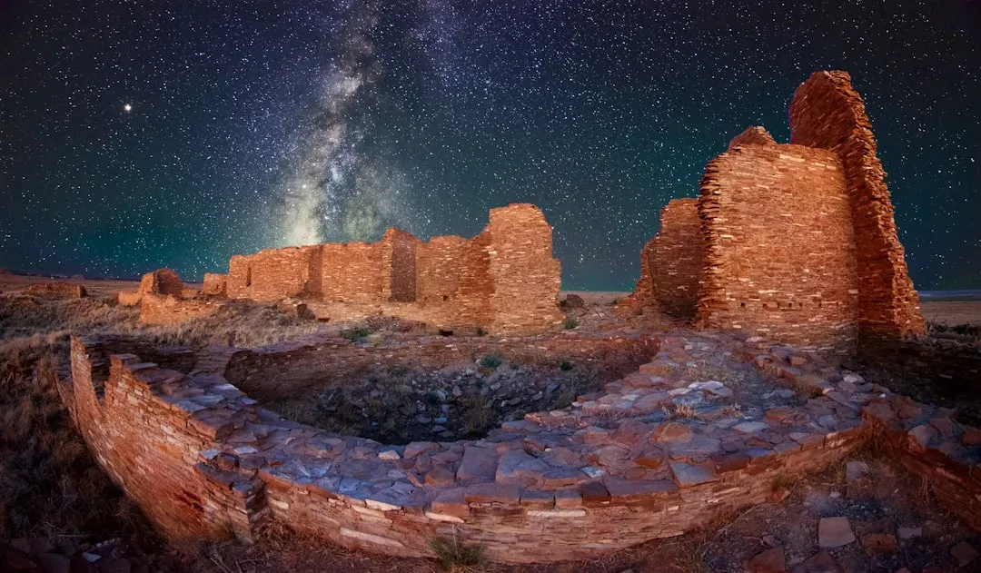
Chaco Canyon’s Mysterious Great Houses and Impossible Road System
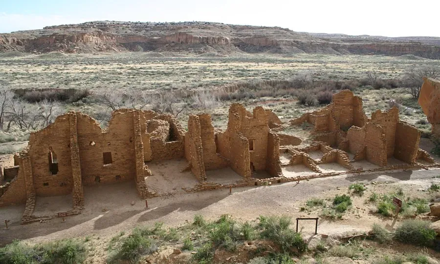
You’ll find that scientists have struggled to understand Chaco society since its first excavations in the late 1800s, and who first settled Chaco Canyon around 1,200 years ago is still a mystery. Picture this: massive stone structures rising from an unforgiving desert floor where growing food should have been nearly impossible. The Chaco people transported by foot more than 200,000 timbers to the canyon from more productive lands 55 to 70 miles away, yet these buildings that required such large investment of labor and planning reveal little evidence of residential use.
Here’s where it gets even stranger. Engineered roads stretch across dozens of miles in straight lines to significant landforms, but with little evidence of travel or trade, with one such road, the Great North Road, connecting the central canyon’s ceremonial buildings across 35 miles of desert to a steep badlands canyon in the North. Why build perfectly straight roads through brutal terrain if you’re not hauling goods or moving armies? Ancient Chaco residents appear to have regarded six-toed people as special, with having six toes bringing social honor in Chaco society. The more you dig into Chaco, the less sense conventional explanations make.
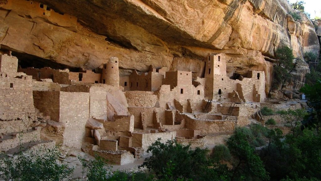
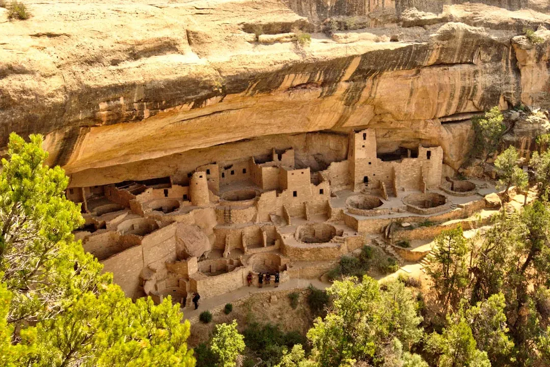
Mesa Verde’s Cliff Dwellings and the Great Abandonment Question
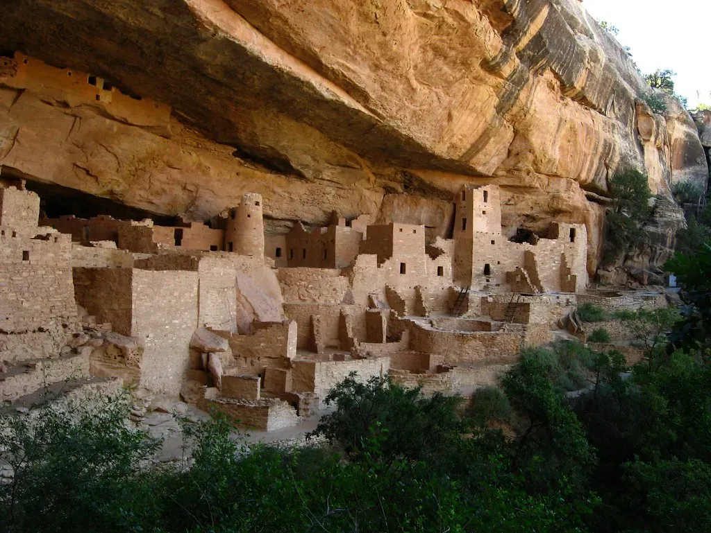
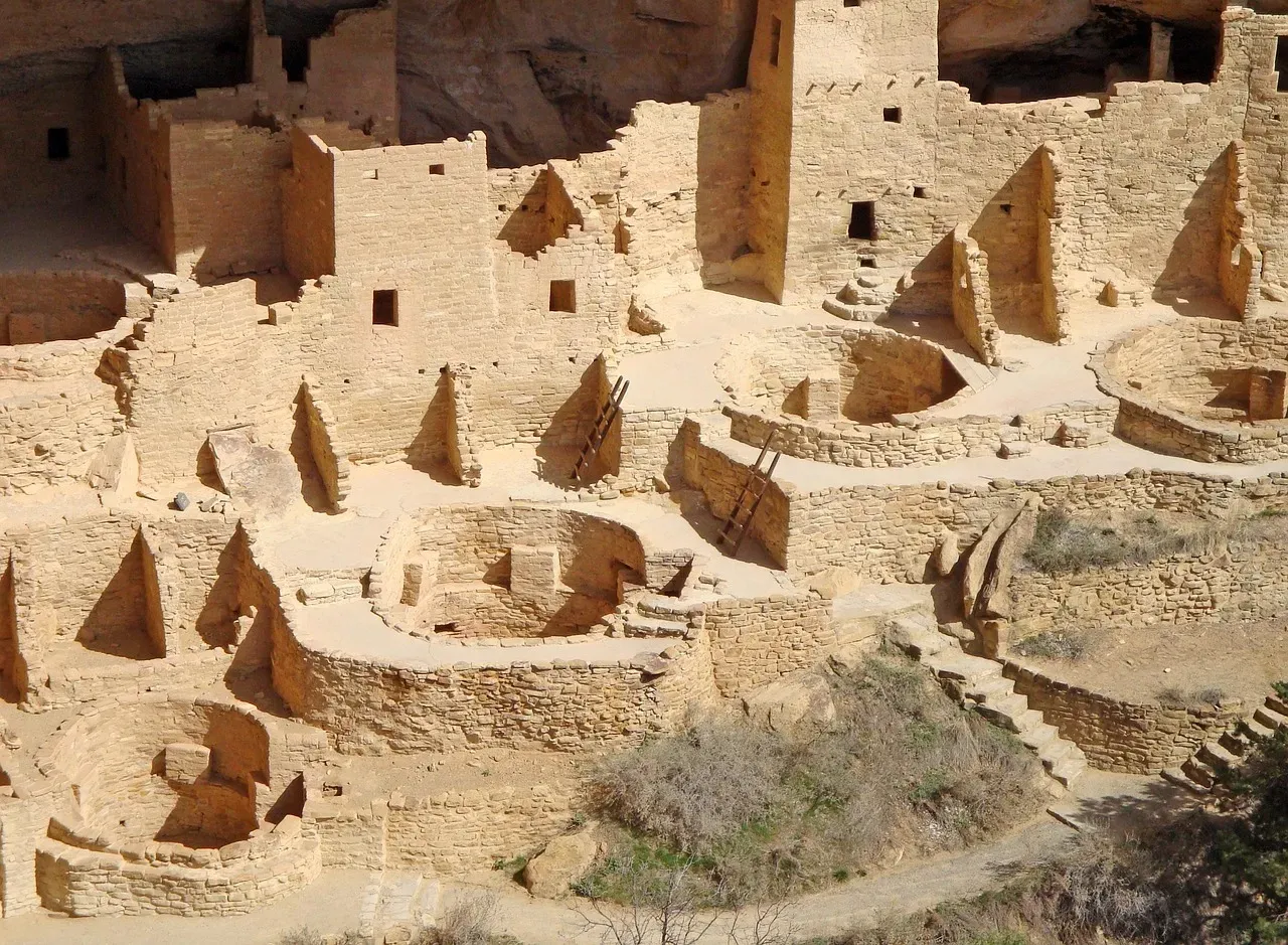
For nearly a century and a half, archaeologists have been studying Mesa Verde in hopes of deciphering what happened to the people who lived and so clearly thrived there for so long, and for many, it remains one of the great mysteries in the history of North America. Think about spending generations carving entire villages into cliffsides, only to walk away. That’s exactly what happened here. Within a few hundred years, the Puebloans had abandoned the mesa top and moved down into the cliffs themselves where they’d learnt to build with stone and constructed houses, kivas, and even whole villages which were carved out of the solid sandstone rock faces, and it’s these cliff houses that make Mesa Verde so special.
But why move into the cliffs at all? No one knows exactly why the Puebloans started building homes within cliffs, though the most common belief is that when the landscape became much drier as the climate became warmer, they decided to move nearer to the water. Researchers encountered ruins that they weren’t sure they could reach even with ropes and modern climbing gear, and researchers believe the Anasazi clambered up felled tree trunks that were notched by stone axes to form minuscule footholds, with these log ladders often propped on ledges hundreds of feet off the ground. The engineering alone seems impossible, let alone the reason for choosing such extreme locations.
The Enigmatic Astronomical Alignments Throughout the Region
Between 850 and 1150 AD, the Chacoan people designed and constructed massive ceremonial buildings in a complex celestial pattern throughout a vast desert region, with aerial and time lapse footage, computer modeling, and interviews with scholars showing how the Chacoan culture designed, oriented and located its major buildings in relationship to the sun and moon. You have to appreciate the precision here. High atop Fajada Butte, three large stone slabs once cast narrow beams of light onto a carved spiral petroglyph, with a single shaft of sunlight piercing the center of the spiral on the summer solstice, while the winter solstice and equinoxes were marked by different light patterns, though public access to Fajada Butte is now restricted to protect the fragile site.
Let’s be real, you don’t accidentally build structures that align with celestial events. Rather than being primarily a trade and redistribution center, it was a center of astronomy and cosmology where a primary purpose for the construction of elaborate Chacoan buildings and certain roads was to express astronomical interests, with landscape, directions, sun and moon, and movement of shadow and light being the materials used by the Chacoan architects and builders to express their knowledge of an order in the universe. This level of astronomical sophistication suggests knowledge systems we’re only beginning to understand.
The Puzzling Outlier Sites and Their Unknown Connections
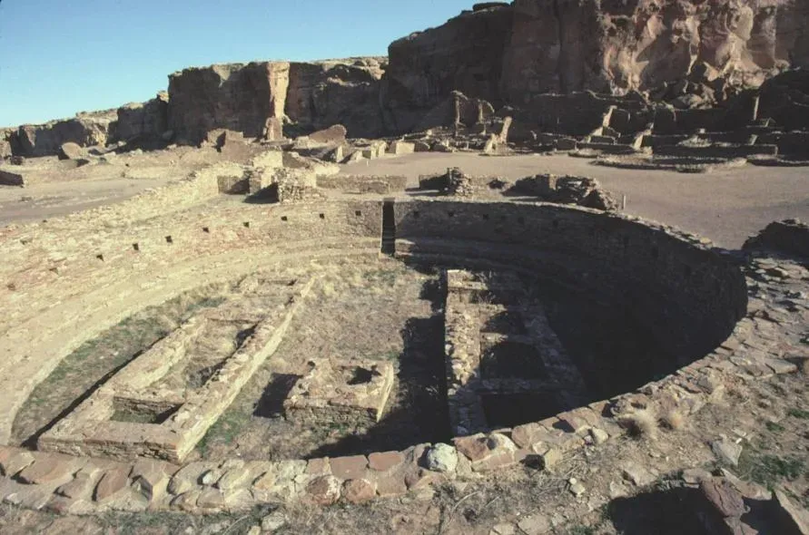
Archaeologists have done little excavation at Pueblo Pintado and most of the other outliers, which undoubtedly conceal a few more clues to the puzzles of Chaco Canyon, the exact nature of its relationship to the outlying communities, and the mystery of its eventual downfall. Scattered across the landscape, you’ll discover smaller versions of Chaco’s grand architecture. These roads formed a grand entry, a very defined procession into places so straight you can draw them with a ruler, while the heaving ground in the central plaza presents another puzzle with depressions and mounds that aren’t typical, indicating a lot went on here after it was built.
The connections between these sites remain frustratingly unclear. Smaller great houses, ritual structures called kivas, groups of small family houses and other urban features, connected by a network of straight dirt roads, fanned out from the canyon across an area the size of Ireland. Were these political outposts? Religious pilgrimage destinations? Trading centers? Archaeologists have debated about the society that created the structures with huge differences of opinion about how elite and powerful the people living in the canyon were, and how egalitarian or hierarchical the culture was.
Unexplained Evidence of Long-Distance Trade Networks
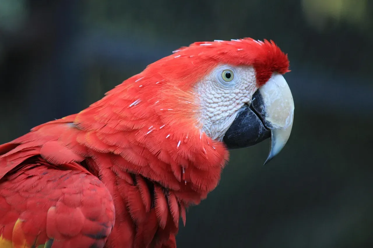
The remains of 34 macaws have been discovered at Chaco, with 14 found in just one room of Pueblo Bonito Chaco Canyon, and these birds native to the jungles over 1,000 miles away were carried north through vast trade networks. I know it sounds crazy, but imagine hauling tropical birds across a thousand miles of desert on foot. Back in 1896, archaeologist George Pepper uncovered 112 cylindrical jars buried in Room 28 of Pueblo Bonito, and research revealed that the jars once held chocolate brought all the way from Mesoamerica.
Chaco people also apparently traded turquoise objects for goods from societies in southern Mexico and Central America, with residue on Pueblo Bonito jars and pitchers coming from a chocolate beverage made from cacao that grows in those tropical areas, and exotic birds like scarlet macaws from the same region turning up at Pueblo Bonito starting in the late 800s. Here’s the thing: this wasn’t casual trade. It required extensive networks, sophisticated logistics and motivations we still don’t fully grasp. What drove people to invest such extraordinary effort in obtaining these specific items?
The Depopulation Mystery That Baffles Modern Science
By the end of the 1200s, tens of thousands of Pueblo people had left the region, and understanding how it happened and where they went are enduring questions central to Southwestern archaeology. Entire civilizations don’t just vanish without reason. Studies show an extended drought may have played a role in pushing people out of the Mesa Verde region, in addition to societal issues like violence, politics and overcrowding, but for 100 years, archaeologists have argued over the answer to the question of where they went.
The Tewa Puebloans had passed their oral histories down generation to generation through seven centuries, knowing they were descendants of the cliff-dwelling Mesa Verde people, with their stories telling of a twelve-step journey south to the modern-day Tewa Basin north of Santa Fe. It’s hard to say for sure, but recent research suggests these oral traditions may hold more truth than archaeologists initially believed. Data-crunching software and computer modeling are helping scientists mine Mesa Verde’s trove of archaeological data like never before, revealing new details about the conditions that precipitated southwest Colorado’s mysterious depopulation, with a map based on research showing that the number of people who disappeared from Mesa Verde during the 1200s was roughly the same as the number of people who moved into the Tewa Basin shortly thereafter.
Conclusion
The American Southwest refuses to surrender all its mysteries easily. After more than a century of excavation, analysis and technological advancement, we’ve learned remarkable things about the people who built these incredible structures. Still, fundamental questions remain unanswered. Why did they build roads to nowhere? What drove them to create such precise astronomical alignments? How did they maintain trade networks spanning thousands of miles without pack animals?
Perhaps the most humbling realization is that despite our modern tools and scientific methods, we’re still piecing together a puzzle with missing pieces. These six sites remind us that ancient peoples possessed knowledge, motivations and capabilities we’re only beginning to comprehend. The desert keeps some secrets buried deep, and maybe that’s exactly how it should be. What do you think drove these ancient civilizations to such extraordinary achievements? Tell us in the comments.

Hi, I’m Andrew, and I come from India. Experienced content specialist with a passion for writing. My forte includes health and wellness, Travel, Animals, and Nature. A nature nomad, I am obsessed with mountains and love high-altitude trekking. I have been on several Himalayan treks in India including the Everest Base Camp in Nepal, a profound experience.