From lava-frozen forests buried under lakes to dunes that sing and stones that seem to walk on their own, the United States is threaded with geological oddities that look almost too strange to be real. Many of these places sit well outside the famous postcard circuits of Yellowstone or the Grand Canyon, quietly rewriting what geologists thought they knew about Earth’s past. At a time when climate extremes, groundwater depletion, and ecosystem loss feel abstract, these sites offer something different: solid rock that tells a story you can literally stand on. The mystery is not just how these formations came to be, but what they’re still revealing about past oceans, vanished glaciers, super-eruptions, and future risks. Think of this tour as both a travel wish list and a toolkit for seeing the country’s landscapes with sharper, more curious eyes.
Crater of Diamonds State Park, Arkansas: A Volcanic Pipe You Can Dig For
It sounds like myth, but in southwest Arkansas you can pay a modest fee, walk into a plowed field, and legally keep any diamonds you find. Crater of Diamonds State Park sits atop an eroded volcanic pipe that punched through the crust roughly many tens of millions of years ago, dragging deep-mantle rocks and crystals toward the surface. Unlike commercial diamond mines, this field has been deliberately left unpaved and unmechanized, turning it into a working open-air geology lab where tourists double as prospectors. Heavy rains rework the soil, naturally concentrating denser stones, which means a sudden downpour can turn into a geologist’s version of a stock-market rally the next day.
Scientists study the ultramafic rocks and mantle xenoliths here to better understand how deep-carbon moves from Earth’s interior toward the surface. The diamonds themselves are physical time capsules, preserving conditions hundreds of kilometers down where pressures crush ordinary minerals into exotic forms. For visitors, the park gently bridges that abstract science with something surprisingly emotional: the thrill of kneeling in the mud, spotting a glint, and realizing it is literally a piece of deep Earth in your hand. It is one of the rare places where the boundary between high-level geophysics and family vacation is only a few inches of dirt.
The Racetrack Playa, Death Valley, California: Stones That Seem to Walk
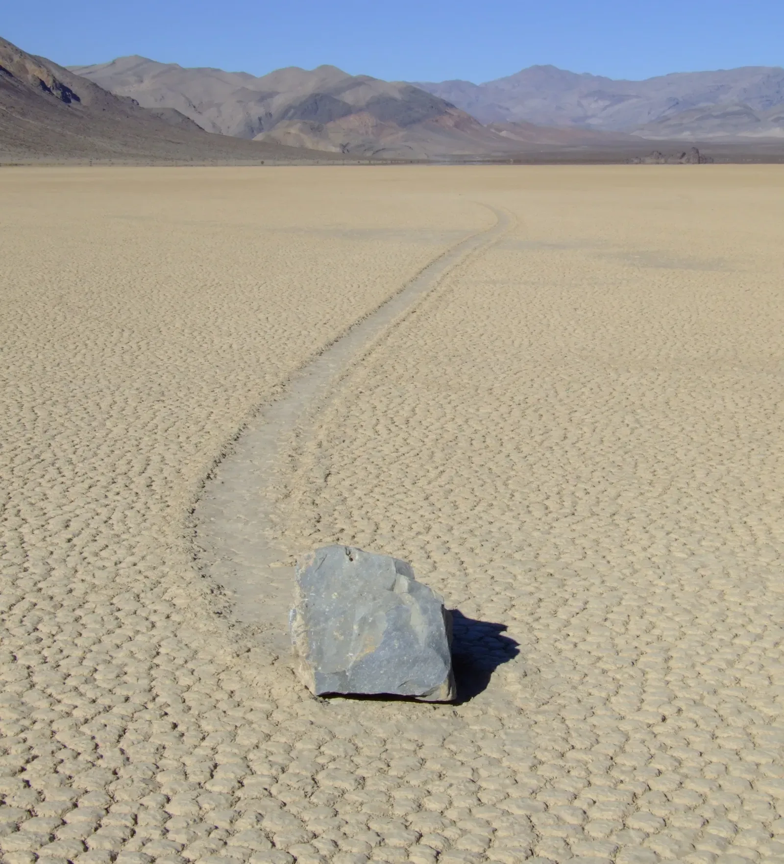
Scattered across the cracked clay of the Racetrack Playa are dark stones that leave long, snaking trails behind them, as if they somehow slid or walked across the desert floor. For decades, no one had definitively seen them move, and the playa’s remoteness made installation of instruments difficult, feeding all sorts of wild speculation. In the last decade, time-lapse GPS tracking and careful field work finally captured the motion during rare winter conditions when thin sheets of ice form, then break up under light winds. The rocks are rafted along on these fragile ice panels, creeping a few inches at a time in near silence.
This process may sound almost mundane once described, but it highlights a powerful truth about Earth’s surface: small forces operating over long periods can leave dramatic, lasting signatures. The Racetrack is also a sensitive environment, where even a single set of tire tracks can scar the playa for decades, a reminder that geological timescales and human impatience often collide. When you stand in that wide, echoing basin surrounded by dark desert mountains, the rock trails look like frozen lines of handwriting across a blank page. It feels less like a solved mystery and more like a lesson in how patient observation can turn a seemingly supernatural phenomenon into a subtle, beautiful bit of physics.
Mono Lake’s Tufa Towers, California: Ancient Water Chemistry on Display
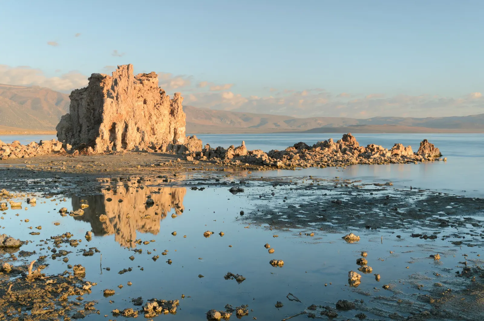
From a distance, Mono Lake in eastern California looks like any other high desert lake, but as you approach the shore, pale, knobby stone towers rise out of the water like the ruins of some drowned city. These are tufa towers, formed when calcium-rich freshwater springs bubble up through the lake’s alkaline, carbonate-heavy waters, precipitating limestone around the rising bubbles. Over centuries, that slow mineral build-up creates hollow chimneys and spires; only when lake levels drop do those delicate towers emerge into the open air. Human water diversions in the twentieth century lowered Mono Lake dramatically, suddenly revealing forest-like fields of tufa along the shoreline.
For geochemists, Mono Lake is a natural workshop for understanding how minerals trap carbon and how closed-basin lakes respond to climate shifts and water extraction. The chemistry here is so unusual that it has hosted research into extremophile microbes and analogs for ancient Martian lakes. At the same time, there is a very grounded story about policy and restoration, as legal battles and conservation efforts have slowly nudged lake levels back upward. Walking among the tufa at sunrise, when the light turns the towers honey-gold, you can feel how intimately geology, water politics, and biology are intertwined. It is hard not to look at those towers and wonder what other hidden structures are quietly forming underwater today.
White Sands National Park, New Mexico: A Moving Sea of Gypsum
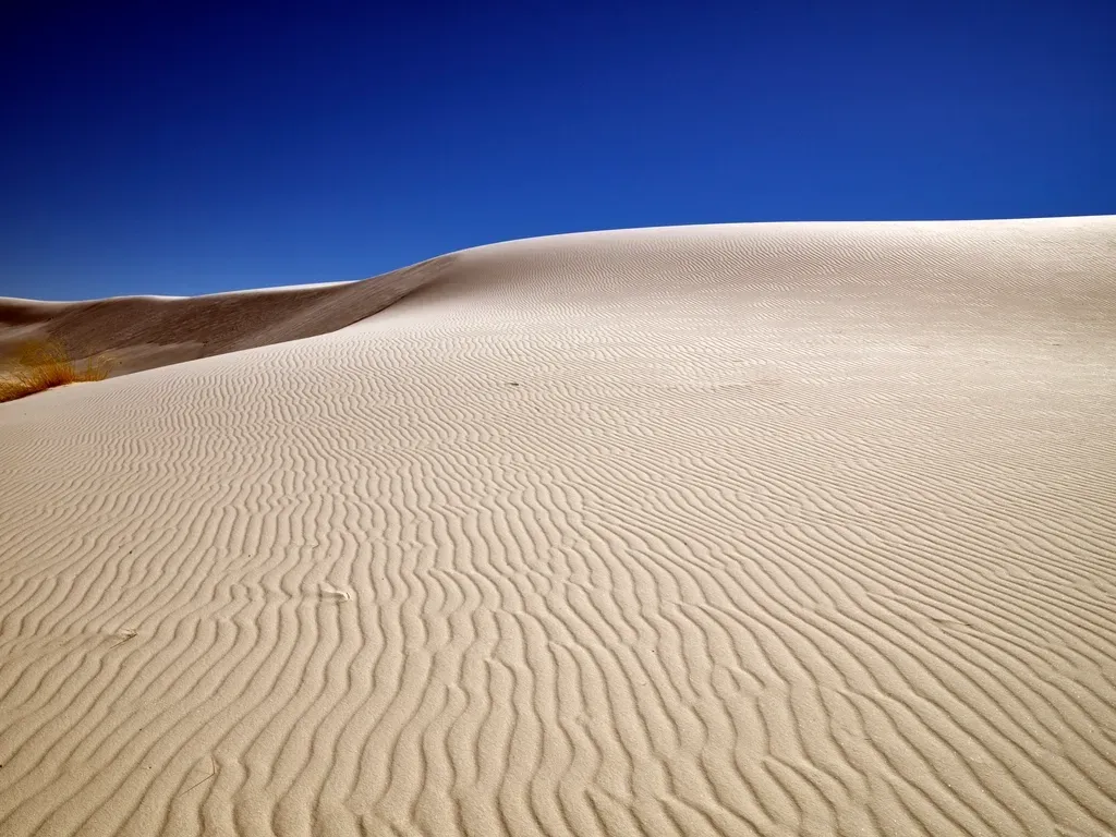
White Sands looks like a mirage: wave after wave of dazzling white dunes that, in photos, often pass for snowdrifts. Unlike most dune fields, which form from quartz sand, these are almost pure gypsum, a soft mineral that normally dissolves in water before it can build dunes. Here, a closed basin and intense evaporation from a shallow lake trap dissolved gypsum, which then crystallizes, breaks down into sand-size grains, and is blown into vast, rippling ridges. The result is one of the largest gypsum dune fields on Earth, reflecting so much sunlight that the ground stays surprisingly cool underfoot even in brutal summer heat.
Paleontologists recently made one of the most dramatic discoveries in North American archaeology and geology at White Sands: ancient human and megafauna footprints preserved in hardened lakebed sediments at the dune margins. These trackways capture scenes of people walking alongside giant ground sloths and mammoths, offering a rare, almost cinematic snapshot of late Ice Age life. The site underscores how surface processes like evaporation and sedimentation can accidentally create perfect archival layers of human and animal motion. Every time a storm reshapes the dunes, new windows into that buried history can open while others are erased. It turns a simple walk along a dune crest into an encounter with deep time only a few inches below your feet.
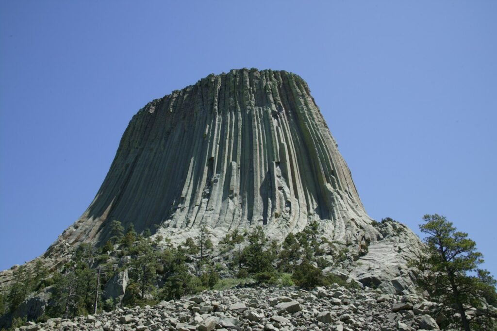
Devils Tower, Wyoming: A Magma Column Frozen in Mid-Rise
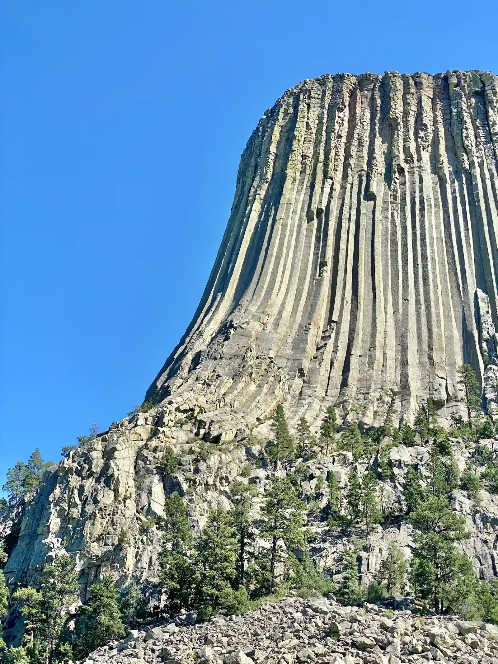
Devils Tower rises abruptly from the rolling plains of northeastern Wyoming, its sheer columns looking more like a massive organ pipe than a natural rock. Geologically, it is the exposed heart of an ancient igneous intrusion, where magma pushed upward but never quite made it to the surface to erupt. As the molten rock cooled slowly underground, it contracted and fractured into long, geometric columns, similar to the structures seen in basalt flows like the Giant’s Causeway, but here preserved as a tower instead of a flat pavement. Over millions of years, softer surrounding sediments eroded away, leaving the harder igneous core standing alone.
The tower is both a climbing mecca and a sacred site for multiple Indigenous nations, and that tension has sparked thoughtful discussions about access, respect, and shared stewardship. From a scientific standpoint, Devils Tower offers insights into how magma bodies cool, fracture, and then get exhumed by erosion, revealing the plumbing of long-dead volcanic systems. When you trace one of those columns skyward with your eyes, you are effectively reading the cooling history of a magma chamber line by line. The fact that this geologic process happens quietly underground in countless places, but rarely ends up this perfectly exposed, is part of what makes the monument feel almost improbable. Standing at its base, you get a visceral sense of how erosion is not just destruction, but a sculptor revealing inner structures that were never meant to be seen.
Fossil Butte, Wyoming: A Lake Bed Turned Stone Archive
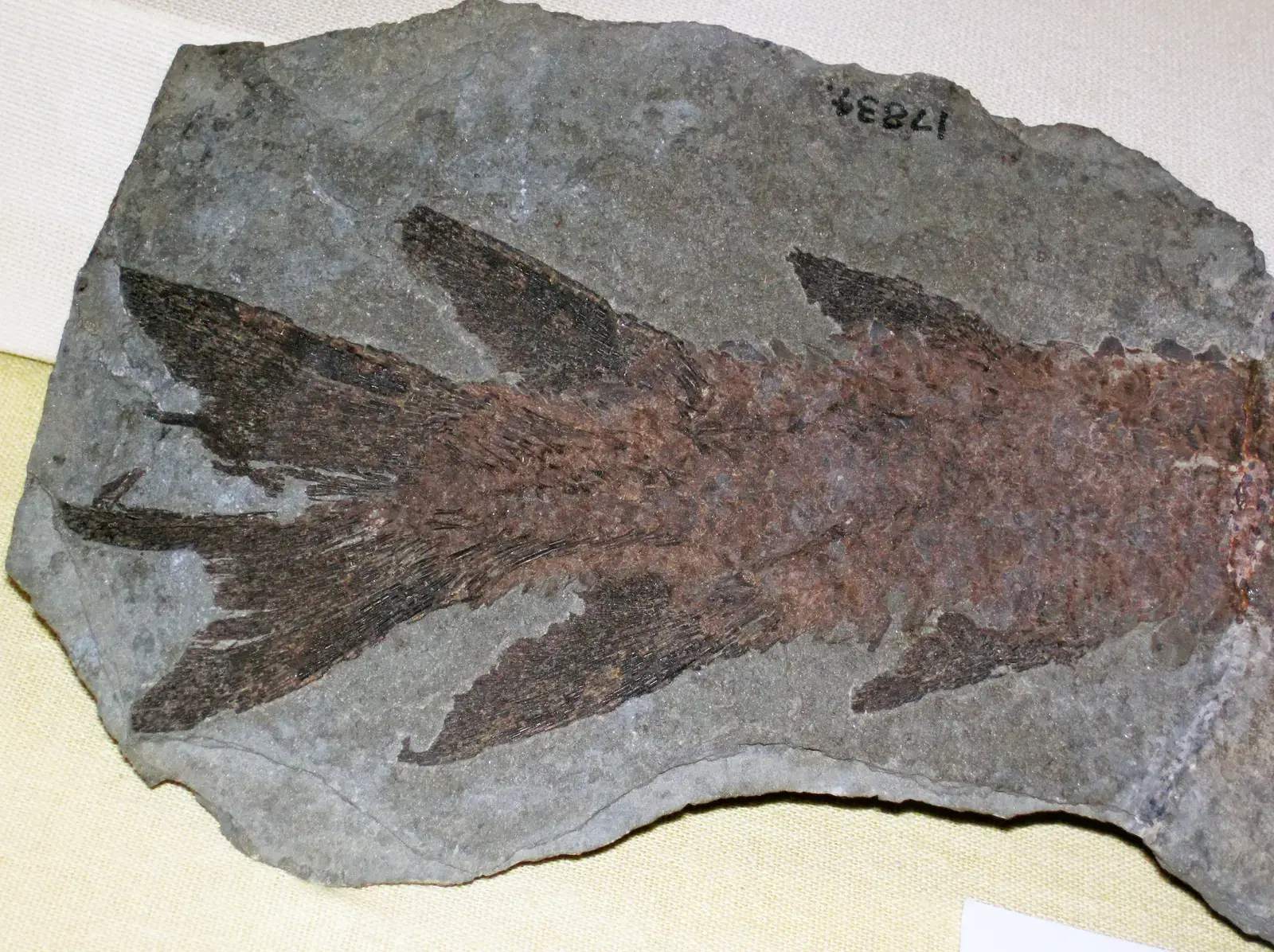
In southwestern Wyoming, Fossil Butte looks unassuming from the highway, but its cliffs hold some of the world’s most exquisitely preserved fossil fish. Around fifty million years ago, this region hosted a chain of subtropical lakes where fine-grained carbonate mud slowly buried dead fish, insects, and plants under low-oxygen conditions that slowed decay. Layer upon layer of sediment compressed into paper-thin limestone sheets, preserving skeletons, scales, and even delicate fin rays in almost artistic detail. Today, careful quarrying in designated research and commercial zones peels back those layers like pages in a stone book.
Geologists and paleontologists use the site to reconstruct ancient food webs, seasonal cycles, and even atmospheric conditions from microchemical signatures in the rocks. It is a reminder that lake sediments can serve as climate loggers, storing information about rainfall, temperature, and ecosystem health at an annual or even seasonal resolution. Visitors often describe the strange feeling of watching a fossil fish appear with each tap of a chisel, as if rewinding millions of years in a few minutes. Fossil Butte shows how a seemingly quiet, ordinary setting – a lake basin infilling over time – can become an archive as precise and information-rich as any library, provided the chemistry and burial conditions line up just right.
Great Sand Dunes National Park, Colorado: The Tallest Dunes Framed by Ice and Rock
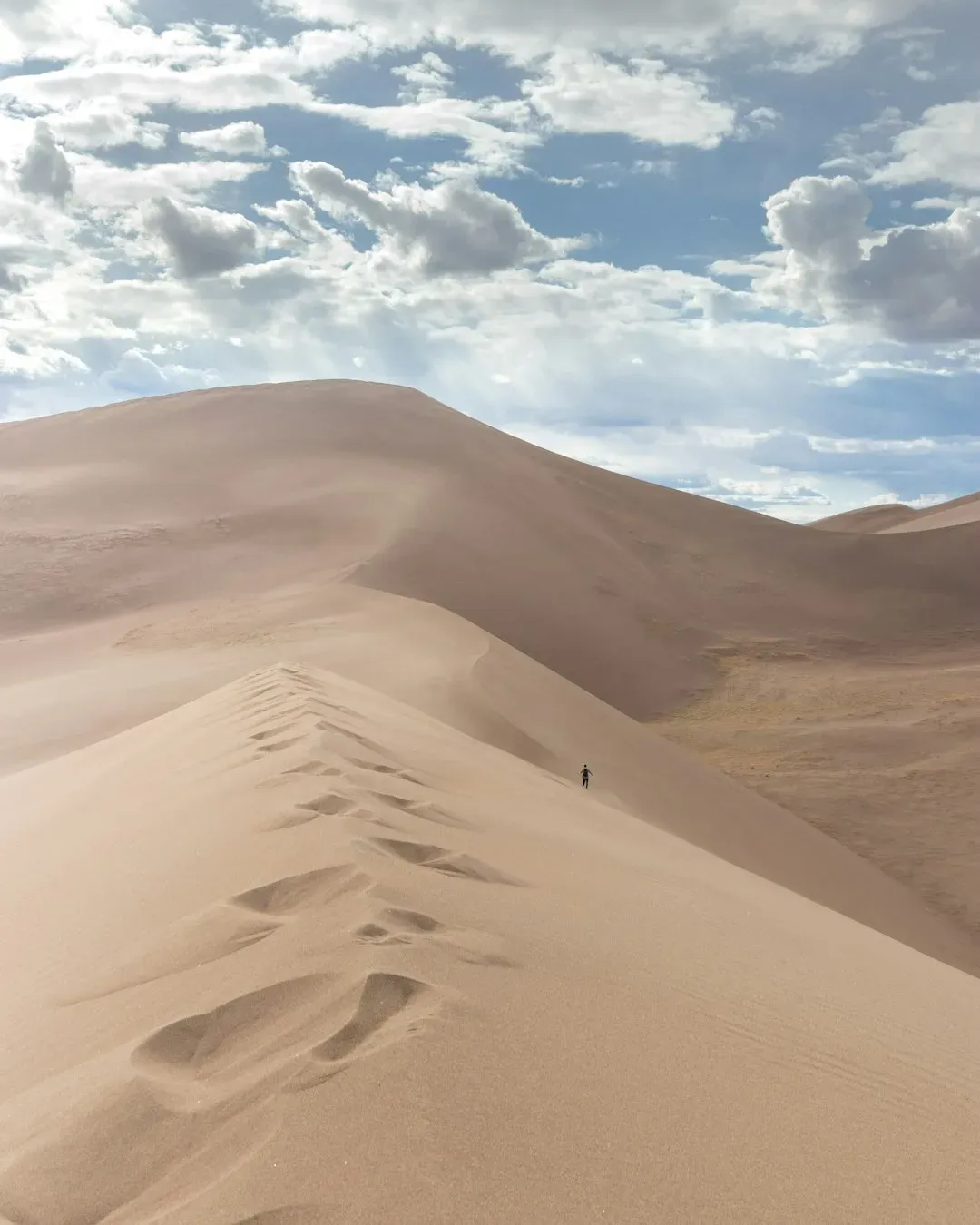
Great Sand Dunes National Park sits where you least expect it: a towering wall of sand piled against the snowy Sangre de Cristo Mountains in southern Colorado. These are the tallest dunes in North America, built from sand blown off an ancient floodplain and then trapped by a combination of mountain walls and shifting winds. Seasonal streams like Medano and Sand Creeks act as conveyor belts, washing sand back toward the dunes where wind can lift it again, powering a sort of endless loop. You can actually feel the sand buzz and hum in places when it avalanches, a phenomenon known as singing or booming dunes.
Scientists study the dunes to understand how wind fields, water flow, and sediment supply interact, which is increasingly relevant as desertification and dust storms affect more communities. The park also offers a natural laboratory for monitoring how snowpack, runoff timing, and climate patterns reconfigure dune edges and associated wetlands. Hiking a ridge at sunset, with alpine peaks on one side and a sea of sand on the other, it is hard not to think about how thin the boundary is between stable landscapes and shifting ones. The dunes are a reminder that even seemingly permanent landforms are the product of ongoing negotiations between water, wind, and gravity. That negotiation is exactly what many western communities now face as snowpacks shrink and river regimes change.
Mammoth Cave, Kentucky: The World’s Longest Known Cave System
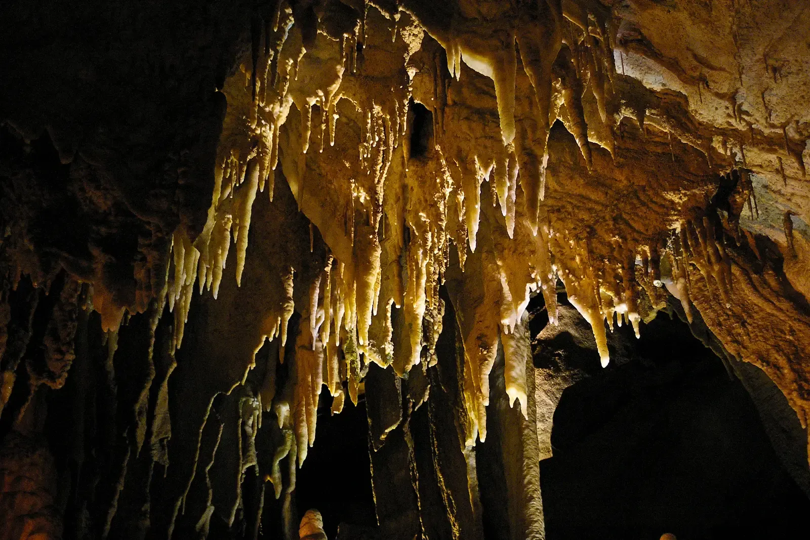
Beneath the forests and farms of central Kentucky lies Mammoth Cave, a sprawling labyrinth of passages that, in mapped length, stretches hundreds of miles and continues to grow as explorers push new surveys. The cave formed in thick Mississippian-age limestones as slightly acidic rain and groundwater dissolved pathways over millions of years, carving multi-level corridors at different historical water-table positions. What makes Mammoth especially intriguing is its vertical stacking of ancient river passages, almost like a cross-section through the region’s hydrological history. Each level records an older set of drainage patterns now abandoned as the surface uplifted and rivers cut deeper.
Hydrologists and geologists use Mammoth Cave and its karst landscape to study how groundwater moves through fractured rock, which is directly relevant to drinking water supplies in many rural regions. The cave system also hosts unique ecosystems, from blind fish to specialized microbes that thrive in nutrient-poor darkness, making it a living laboratory for evolutionary biology. Walking through the largest chambers, your sense of scale starts to bend as ceilings soar and side tunnels vanish into blackness. It feels less like a cave in the storybook sense and more like a buried river network, complete with its own weather, acoustics, and hazards. That complexity is a sharp contrast to how casually we often talk about “groundwater” as if it were stored in simple underground lakes.
Why These Hidden Geological Sites Matter
At first glance, places like Crater of Diamonds, White Sands, or Fossil Butte might seem like quirky road-trip stops, but together they function as a distributed observatory on how Earth works. Each site reveals a different piece of the puzzle: mantle chemistry, sediment archives, climate feedbacks, groundwater behavior, or erosion and uplift. When scientists stitch data from these locations together, they can test models of how ice sheets retreat, how volcanic systems evolve, or how quickly deserts advance. That matters directly for forecasting hazards such as groundwater contamination, dust storms, landslides, and even future volcanic risks.
Compared with traditional laboratory experiments or short-term field campaigns, these geologic wonders offer extended, naturally running experiments that have been operating for thousands to millions of years. They anchor abstract discussions about climate or tectonics in specific, observable structures that citizens can visit, photograph, and even participate in monitoring. Many of these parks and monuments also sit on the front lines of policy debates over water diversions, mining, and recreation impacts. In that sense, they are not just backdrops but active players in how the United States negotiates resource use, cultural values, and scientific knowledge. Appreciating them as more than scenic stops is one quiet but powerful way to ground the national conversation about environmental change in actual rock and soil rather than just charts and slogans.
The Future Landscape: Technology, Threats, and New Discoveries
Looking ahead, the most dramatic changes to these sites may not come from sudden disasters but from steady shifts in climate, visitation, and land use. Rising temperatures and altered precipitation patterns will likely reshape dune migration at Great Sand Dunes and White Sands, while changing snowpacks and rainfall intensity could alter recharge in karst systems like Mammoth Cave. Remote sensing, drone mapping, and high-resolution satellite imagery are already allowing scientists to track subtle changes, from tufa exposure at Mono Lake to microfracturing on exposed cliffs like Devils Tower. Low-cost sensors and community science apps may turn casual visitors into data collectors, feeding continuous streams of measurements into national databases.
At the same time, these landscapes face real pressures: overcrowding, vandalism, illegal off-road driving, and the quiet creep of nearby development that changes groundwater and sediment flows. A few stray vehicle ruts across the Racetrack Playa or careless handling of ancient footprints at White Sands can erase information that took millennia to assemble. Policy decisions about water diversions, mining leases, or road building will shape whether some of these places remain intact reference sites or fragmented, partially compromised records. The optimistic view is that better storytelling, stronger partnerships with Tribal and local communities, and more visible science can build broader public support for protection. The rocks are not going anywhere on human timescales, but the stories we are still able to read from them depend very much on what we do in the next few decades.
How You Can Engage With America’s Hidden Geology
Engaging with these geological wonders does not require advanced degrees or expensive expeditions; it starts with choosing destinations that offer both beauty and scientific depth, then showing up with curiosity. Visiting parks like White Sands, Mono Lake, Great Sand Dunes, or Mammoth Cave with a field guide or park app in hand can turn a scenic stop into a real-time geology class. Simple actions make a difference on the ground: staying on established paths, resisting the urge to carve initials into rock or drive on fragile playa surfaces, and following local guidance about sensitive cultural and ecological areas. Many parks and preserves run volunteer programs that range from trail maintenance to joining bioblitzes and assisting with basic monitoring.
If travel is not feasible, you can still support the science and preservation behind these places by backing organizations that fund geological mapping, climate research, and land conservation. Public comment periods on environmental impact statements or land management plans are often open to anyone, and they are a surprisingly direct way to weigh in on how these landscapes are treated. Teachers and parents can weave these sites into lessons and stories, using them as tangible examples when discussing topics like groundwater, climate change, or plate tectonics. Even following researchers and park geologists on social media can sharpen your sense of how dynamic these “static” landscapes really are. The next time you scroll past a photo of a lonely tower of rock or a mysterious set of tracks in the desert, it might be worth pausing to ask what experiment Earth has been quietly running there – and what role you want to play in keeping it going.

Suhail Ahmed is a passionate digital professional and nature enthusiast with over 8 years of experience in content strategy, SEO, web development, and digital operations. Alongside his freelance journey, Suhail actively contributes to nature and wildlife platforms like Discover Wildlife, where he channels his curiosity for the planet into engaging, educational storytelling.
With a strong background in managing digital ecosystems — from ecommerce stores and WordPress websites to social media and automation — Suhail merges technical precision with creative insight. His content reflects a rare balance: SEO-friendly yet deeply human, data-informed yet emotionally resonant.
Driven by a love for discovery and storytelling, Suhail believes in using digital platforms to amplify causes that matter — especially those protecting Earth’s biodiversity and inspiring sustainable living. Whether he’s managing online projects or crafting wildlife content, his goal remains the same: to inform, inspire, and leave a positive digital footprint.