Every rock tells a story, but some formations in the United States feel more like riddles than chapters in a geology textbook. They loom over highways, hide in deserts, sit quietly offshore, and yet their origins still spark passionate debate among scientists and curious travelers. You stand in front of them, run your hand along stone that’s millions of years old, and your brain starts whispering the same question: how on earth did this happen?
Geologists can explain a lot, but a surprising number of formations come with missing puzzle pieces, contested theories, or details that simply don’t add up neatly. That’s where things get interesting. From gravity-defying boulders to eerie circular craters, some landscapes feel almost like nature’s practical jokes. Let’s walk through twelve of the most baffling spots across the US – places where the rocks seem to argue with the rules we were taught in school.
The Devils Tower Enigma – Wyoming’s Giant Stone Monolith
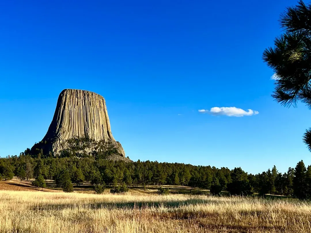
Stand at the base of Devils Tower in northeastern Wyoming and it’s hard not to feel tiny, confused, and a little overwhelmed. This nearly vertical pillar of rock rises dramatically out of rolling prairie, with tall, hexagon-shaped columns stacked together like a bundle of stone pencils. It looks unnervingly artificial, as if someone tried to build a skyscraper here long before concrete was a thing. Yet it’s all natural, towering more than a thousand feet above the surrounding terrain.
Most geologists agree Devils Tower is the remnant of ancient magma that cooled slowly underground, but the arguments start when you ask for exact details. Was it once part of a much larger volcano, or a kind of hardened plug left behind after softer rock eroded away? Different models tell different stories, and there’s still debate on how those unusually perfect columns formed and why they’re exposed so cleanly. When you’re standing below it, cranes of birds circling at the top, it feels like the land is holding onto a secret it isn’t quite ready to share.
Mystery of the Sliding Rocks – Racetrack Playa, Death Valley
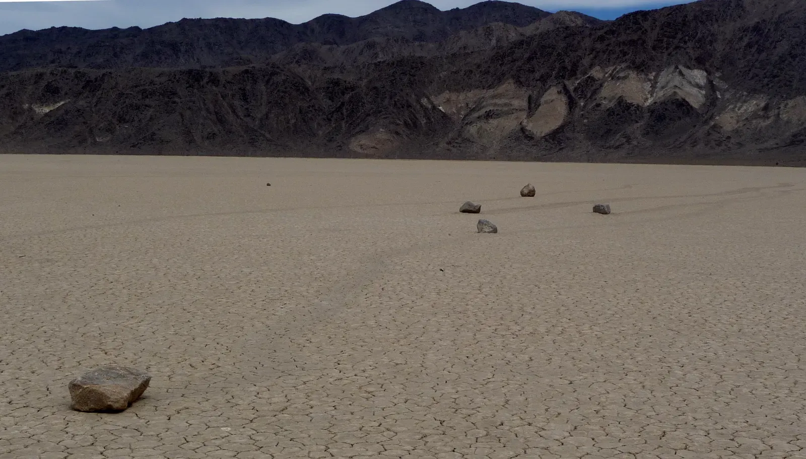
Imagine walking across a dry lake bed in California’s Death Valley and seeing long, dusty trails carved into the cracked mud. At the ends of those trails sit rocks – some small, some the size of microwave ovens – that look like they’ve been dragged across the desert floor by an invisible hand. For decades, these “sailing stones” on Racetrack Playa baffled visitors and scientists alike. There were no footprints, no tracks from vehicles, no clear sign of what moved them.
Modern research suggests a combination of thin ice sheets, shallow water, and steady winds may gently nudge the rocks along, leaving those ghostly tracks behind. But not everyone is satisfied with that explanation, especially because the exact conditions are rare and hard to catch in the act. The motion is slow, subtle, and usually happens when no one is watching. Even knowing the leading theory, it still feels pretty unsettling to stare at those neat trails and imagine heavy stones gliding silently across the desert like they have a will of their own.
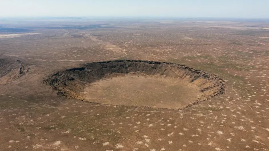
The Great Unfinished Crater – Upheaval Dome, Utah
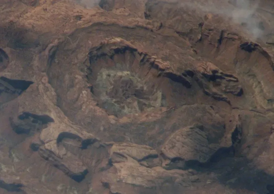
In the middle of Canyonlands National Park in Utah, the land suddenly breaks pattern. Instead of endless layered mesas and canyons, you get Upheaval Dome: a strange, circular structure roughly two miles wide, with jumbled rocks shoved upward in its center like a frozen explosion. From lookout points, it almost resembles an impact crater from another world, except something about it looks half-complete. It’s as if the landscape started to form a crater, got confused midway, and switched to a different blueprint.
For years, geologists argued whether Upheaval Dome was created by a salt dome pushing upward or by a massive meteor impact. Evidence has increasingly leaned toward the impact theory, including signs of shocked quartz that usually forms under extreme pressure. Still, some details of its structure and erosion patterns don’t line up as cleanly as they do with more typical craters. When you hike to the rim and stare down, the ringed walls and chaotic interior feel like a crime scene: clues everywhere, but no definitive confession from the rocks themselves.
The Gravity-Defying Balanced Rock Phenomenon – Colorado and Beyond
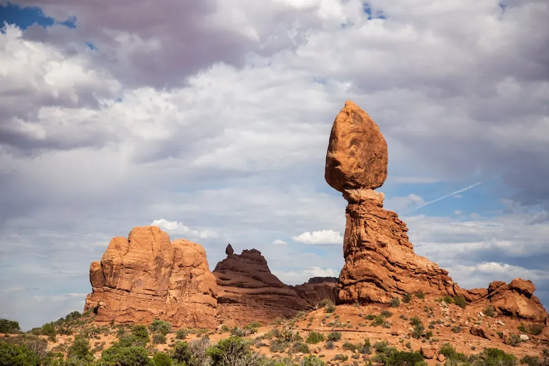
Scattered across the American West – especially Colorado, Utah, and Arizona – you find balanced rocks that look like they’ve been placed there by a mischievous giant. In Colorado’s Garden of the Gods, for instance, a giant reddish boulder rests on a thin, eroded pedestal, appearing one strong breeze away from collapse. Visitors crowd around it, taking photos and quietly expecting to hear the stone groan and tip. But year after year, it just… stays.
Geologists can explain the basics: different rock layers erode at different speeds, so softer rock wears away underneath tougher layers, leaving bizarre shapes behind. The truly unnerving part is how precisely some of these stones are poised, and how long they’ve managed to survive earthquakes, storms, and constant freeze-thaw cycles. Some balanced rocks have likely stood in their precarious positions for thousands of years. When you’re under one, your rational brain knows it’s stable – but a more primitive part of you keeps glancing up, waiting for gravity to finally claim its overdue victory.
The Mysterious “Fairy Circles” of the Great Basin – Nevada’s Strange Spots
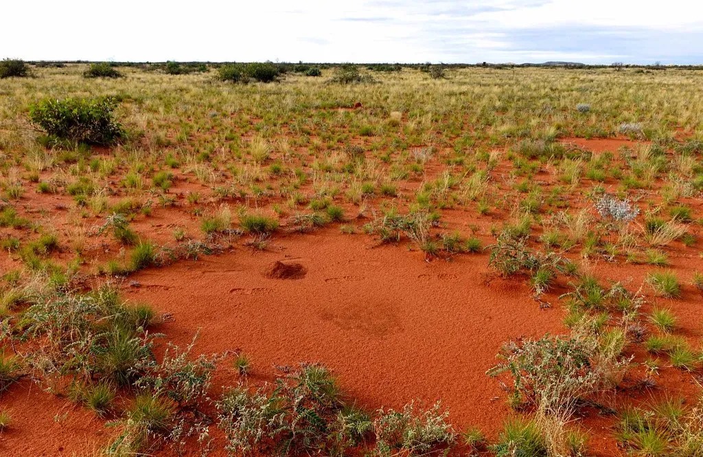
The deserts of Nevada and the wider Great Basin hide a quieter mystery that doesn’t get as many headlines as towering cliffs and giant craters. In some remote, flat areas, you can find odd, ring-shaped patches of bare ground with vegetation circling around them, like nature tried to sketch crop circles but gave up halfway. From the air, they look like faint scars or faded polka dots stamped across the landscape. On the ground, they’re subtle enough that you might walk past a dozen before you realize they’re forming a pattern.
Similar circles in parts of Africa have sparked plenty of theories, ranging from underground termites to plants competing for scarce water in ways that naturally form rings. In the Great Basin, explanations are still being hammered out, with ideas involving soil chemistry, desert crusts, and water pathways. The frustrating part is that multiple factors might be interacting at once, making it hard to pin down a single cause. What you’re left with is a landscape that feels slightly haunted – a place where even the empty patches of ground seem to be trying to tell you something.
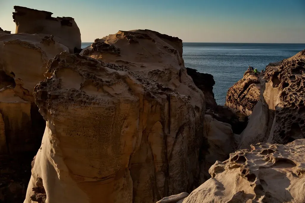
The Stone Forest of South Dakota – Badlands’ Puzzling Pinnacles
Drive through Badlands National Park in South Dakota and the world suddenly shifts from gentle prairie to a snarling maze of jagged ridges and spires. The rock here is soft, layered, and carved into shapes that look more like melted castles than solid cliffs. Some formations rise like thin towers or pointed teeth, eroding so quickly that the landscape is said to be changing noticeably within a human lifetime. The place feels both ancient and alarmingly temporary, like you’re walking through sand sculptures during the last hour of the tide.
Geologically, the ingredients are known: layers of sediment laid down over millions of years, then lifted, cracked, and rapidly carved by wind and water. What throws people off is the intensity and speed of it all. The Badlands erode much faster than many more “typical” mountain ranges, and the formations sometimes look deliberately sculpted into repeating patterns and sharp angles. Standing on a viewpoint, with bands of color running through the rock like a layer cake gone wrong, it’s hard not to feel that you’ve stumbled into a place where the rules of erosion decided to show off.
The Circle that Shouldn’t Be – New Mexico’s Mystery Craters
New Mexico is famous for alien lore, nuclear history, and colorful deserts, but it also hides a less talked-about oddity: small crater-like depressions scattered in certain regions that don’t always fit neatly into volcanic or impact categories. A few show circular rims and central low spots that immediately make people think “meteor,” yet detailed evidence for impacts is missing or ambiguous. Others sit in areas where volcanic activity is known, but their shapes suggest a more explosive, focused event than the surrounding land fully explains.
Geologists have proposed everything from collapsed lava tubes to old maar volcanoes – explosive craters formed by magma meeting groundwater – to explain these features. Still, in several locations, available data is too thin or conflicting, leaving them in a weird limbo between official categories. For travelers stumbling across them, the effect is eerie: you see a shape your brain recognizes from science documentaries, but the backstory is blurred. It’s like finding footprints in the desert and having no idea what kind of creature made them, or even how long ago they passed through.
The Oregon Vortex and Distorted Perception Zones
In southern Oregon, the Oregon Vortex has been marketed for decades as a place where brooms stand up on their own, people appear to shrink or grow depending on where they stand, and balls seem to roll uphill. On paper, it sounds like clever stagecraft and visual trickery, and to a large extent, that’s exactly what skeptics argue it is. The buildings on-site are tilted, the horizon is hard to judge, and your eyes are easily fooled when every reference point is skewed. Still, the on-the-ground experience can feel oddly convincing when you’re there in person.
From a pure geology standpoint, there’s no solid evidence that gravity behaves any differently in this spot than anywhere else. Yet places like this across the US – often called “mystery spots” or “gravity hills” – keep popping up, typically in hilly terrain where slopes can trick the human eye. The odd thing is how similar the stories are, and how people walk away genuinely rattled even after hearing all the rational explanations. The rock and soil might be perfectly ordinary, but our brains’ fragile grasp on what “level” looks like turns these locations into psychological laboratories disguised as roadside attractions.
The Devil’s Kettle – Minnesota’s Vanishing River
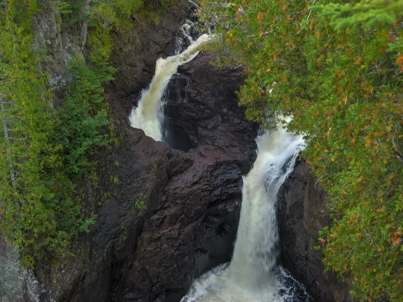
On Minnesota’s North Shore, the Brule River rushes toward Lake Superior, splits in two at a rock outcrop, and does something deeply unsettling. One branch continues downstream like any normal river. The other plunges into a gaping pothole known as the Devil’s Kettle and appears to simply disappear. For years, people tossed in everything from sticks to dye to ping-pong balls, trying to see where the water reemerged, but nothing obvious turned up. It was like watching part of the river fall off the map.
More recent studies and flow measurements suggest that the “missing” water likely rejoins the main river downstream through underground fractures, even though it doesn’t surface in a dramatic spring or obvious outlet. Still, the exact internal plumbing remains hidden, and the early failed experiments added a layer of urban legend that’s hard to shake. Standing at the overlook, cold mist in the air, you can watch thousands of gallons of water vanish into stone every minute. Your rational mind can accept the current best guess, but there’s a stubborn feeling that the river is keeping a private secret passage all to itself.
The Carolina Bays – Oval Lakes with No Clear Origin
Spread across the Atlantic Coastal Plain – especially in the Carolinas – are thousands of shallow, oval depressions known as Carolina Bays. Many are filled with water, forming ponds or wetlands fringed with trees, while others are dry and only visible from the air. Almost all of them share a similar shape and orientation, lined up like someone dragged a giant comb across the landscape. That repeating geometry is what makes them so puzzling; these aren’t random potholes, but they’re not straightforward craters either.
Over the years, people have suggested everything from ancient meteor showers to wind-and-water sculpting to explain the bays. The meteor idea is dramatic and persistent, but direct evidence for impact – such as shocked minerals or clear crater rims – is frustratingly weak. The wind-erosion camp points to how water and sediment might pool and stretch under prevailing winds over long periods. Even so, the sheer number and regularity of the bays leave plenty of room for argument. Flying over them, they look almost too orderly, like nature was doodling with an invisible oval stencil for thousands of years.
The Great Serpent Mound – Ohio’s Earthwork Enigma
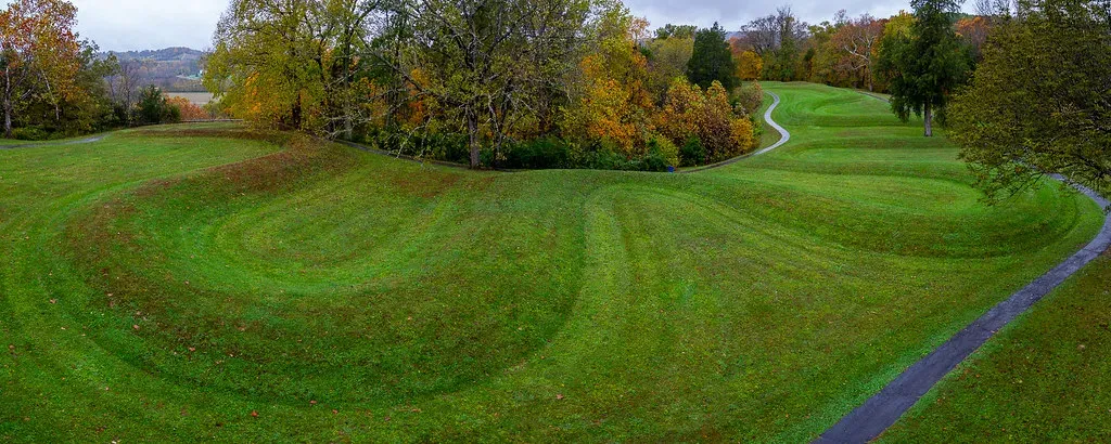
In southern Ohio, the land itself has been shaped into an enormous winding figure commonly interpreted as a snake swallowing an egg or the sun. This is the Great Serpent Mound, a prehistoric earthwork created by Indigenous builders whose exact identity and intentions are still studied and debated. The feature stretches hundreds of feet across a ridge, curling and looping with a precision that stuns anyone seeing it for the first time. From ground level, it’s impressive; from the air, it’s breathtakingly clear and deliberate.
Geologically, the mound sits atop a strangely disturbed area of bedrock that some researchers argue is an ancient impact structure, while others suggest more typical faulting and uplift. That means there may be a double mystery here: a cultural riddle layered on top of a geological one. Scholars have proposed astronomical alignments, ceremonial uses, and symbolic meanings for the Serpent, but no single interpretation has closed the case. Walking along the raised, grassy body of the earthwork, you feel caught between science, history, and spirituality, with the land quietly insisting that not every story is meant to be fully decoded.
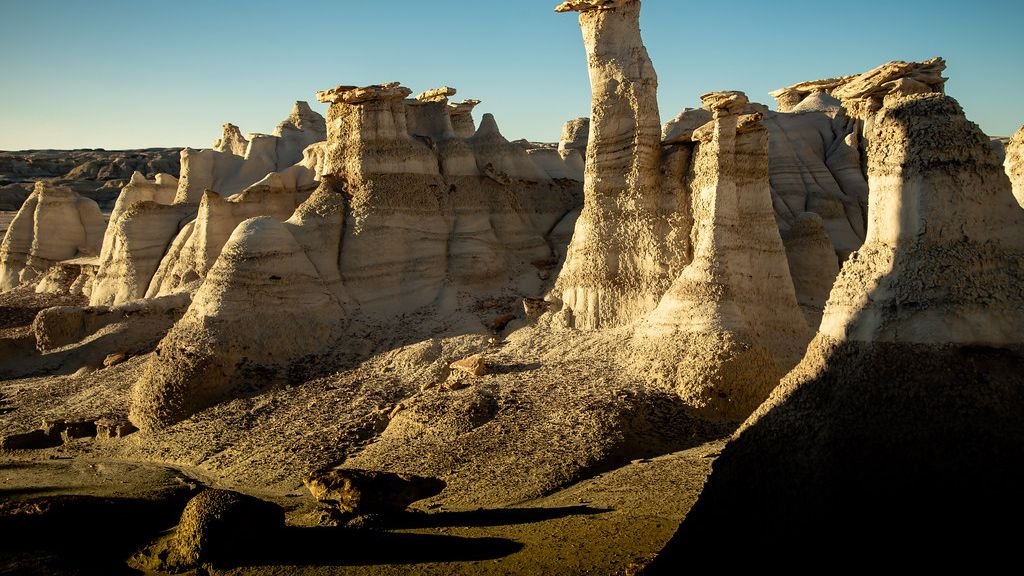
The Fairy Chimneys of New Mexico – Tent Rocks and Stone Tents
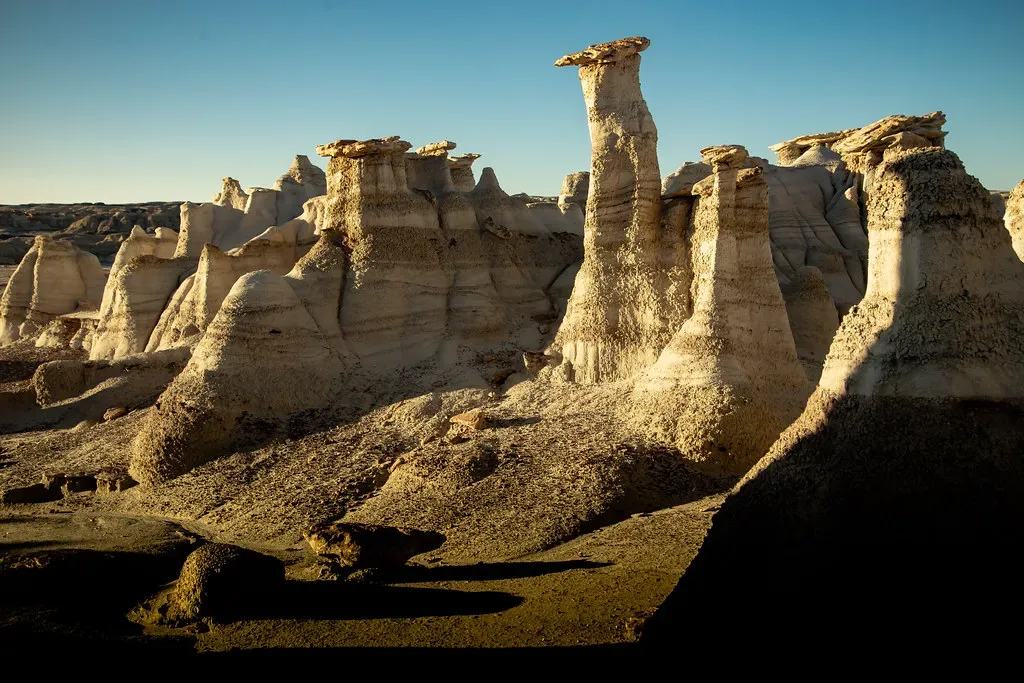
Near Cochiti Pueblo in New Mexico, the landscape abruptly shifts into what looks like a campsite for giants. Tall, conical rock formations – often capped with harder stones – rise in clusters, resembling tents or pointed hats. These so-called “fairy chimneys” or hoodoos formed from layers of volcanic ash and tuff that erode in strange, uneven ways. In narrow canyons between them, the light bounces off softly colored walls, and it feels like you’ve stepped onto the set of an otherworldly film.
The general recipe for hoodoos is known: softer rock wears away more quickly than harder capstones, protecting columns underneath. What puzzles people here and in similar spots is the uncanny regularity of the shapes and how often they seem to mimic human-made structures. Some formations taper perfectly, as if shaped on purpose, while others cluster in patterns that look almost architectural. You know the explanation is erosion, but walking among them, it’s hard to shake the feeling that you’ve wandered into a stone village built by something with a very different sense of time than ours.
Conclusion – When the Earth Refuses to Be Simple
Across the United States, these baffling formations remind us that the ground under our feet is anything but straightforward. Even with modern instruments, satellite imagery, and carefully tested theories, there are still gaps, arguments, and quiet geological riddles we haven’t fully solved. Every time we think we’ve got a complete answer, a new detail or outlier appears and forces us to reconsider what we were so sure we understood. That tension between knowledge and mystery is part of what makes these places so compelling to visit.
Maybe that’s the real power of these odd rocks, craters, and stone forests: they tug us out of our everyday assumptions and make us feel small in the best possible way. You stare at an ancient column, a vanishing river, or a perfect oval lake, and suddenly your own timeline feels very, very short. The planet has been experimenting with shapes and forces for far longer than we’ve been around to name them. When you look at these twelve formations, which one would you most want to stand in front of and see with your own eyes?