Picture this: you’re scrolling through your social media feed when suddenly you see a video of ghostly apparitions floating above thunderclouds, or photographs of what appear to be burning rainbows hanging in the sky. Your first instinct might be to call it fake news or clever digital manipulation. Yet these phenomena are absolutely real, captured by countless observers around the world and studied extensively by meteorologists.
Our planet’s atmosphere is far more theatrical than most people realize. While we’re familiar with everyday weather like rain, snow, and sunshine, there exists a hidden world of atmospheric drama that unfolds regularly above our heads. These rare meteorological events are so spectacular and unusual that they seem more suited to a fantasy novel than our everyday reality.
Ball Lightning: Nature’s Floating Plasma Show
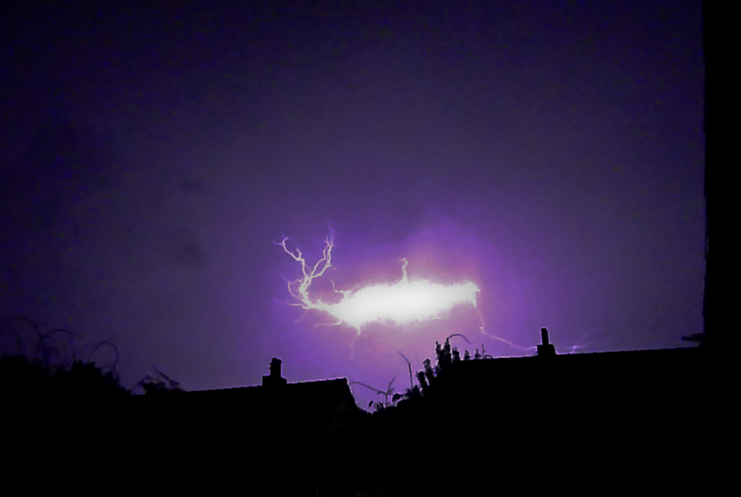
Imagine walking through your living room during a thunderstorm when suddenly a glowing sphere of electricity hovers, spins, and sometimes passes through windows before vanishing with a pop. Ball lightning is a rare and unexplained phenomenon described as luminescent, spherical objects that vary from pea-sized to several meters in diameter. For decades, scientists dismissed reports of these floating orbs as hallucinations or misidentified conventional lightning.
In 2012, scientists in China caught ball lightning on video, proving it exists, and Russian scientists successfully made plasma balls in the lab in 2002 – catching the attention of Mike Lindsay, then a student at the U.S. Air Force Academy, who wondered if he could recreate and study the phenomenon. These mysterious spheres can float through solid objects, emit sulfurous odors when they disappear, and have been blamed for unexplained accidents involving high-altitude aircraft operations.
The phenomenon gained historical recognition during World War II when pilots reported glowing spheres pacing their planes, calling them “foo fighters”. One of the most famous historical accounts occurred at a church in Devon, England in 1638, when a ball of fire reportedly struck and entered the church, killing four people and injuring sixty others.
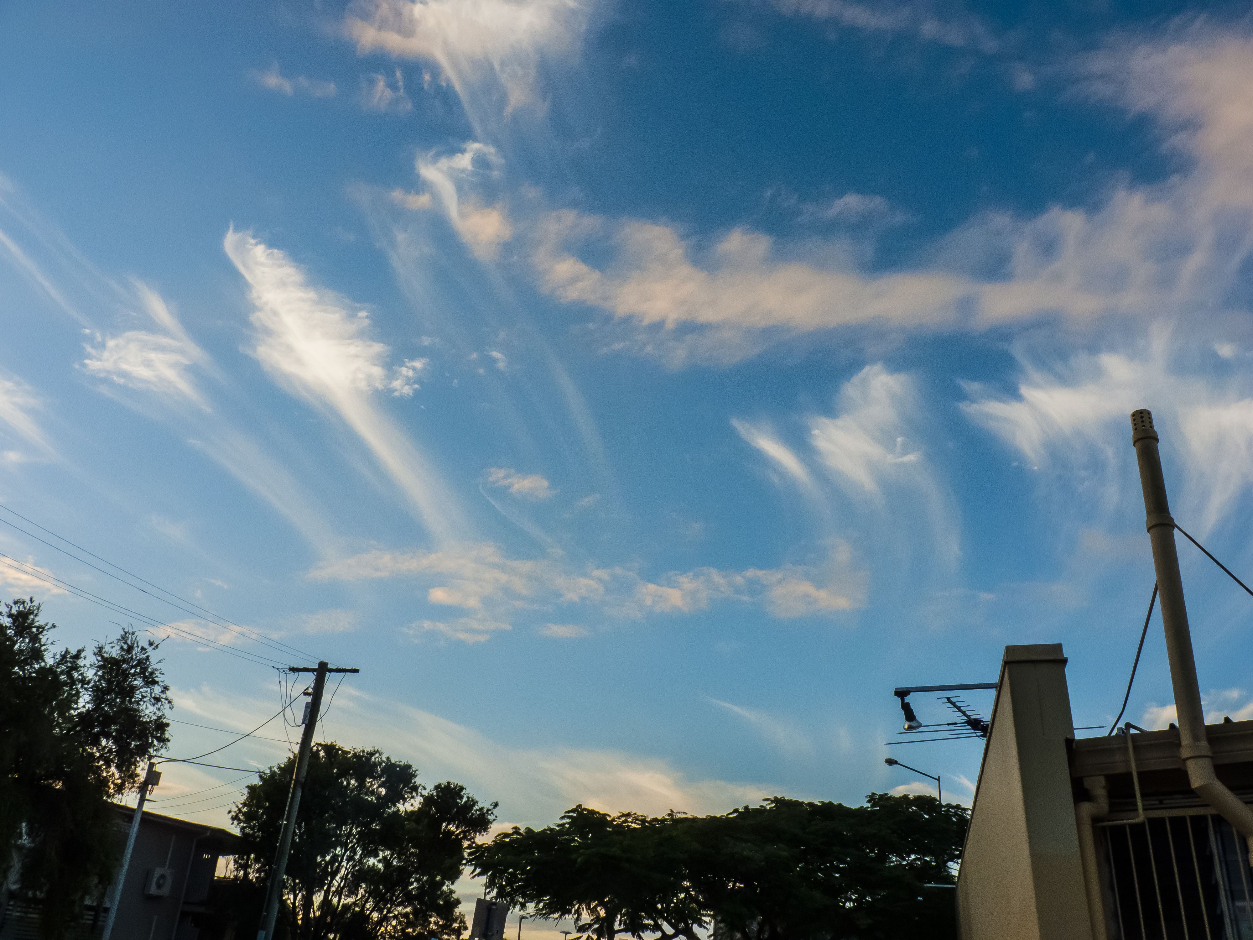
Fire Rainbows: When Ice Creates Flames in the Sky

Fire rainbows, or circumhorizontal arcs, form when sunlight refracts through ice crystals in cirrus clouds, creating vivid, colorful phenomena in the sky, typically during summer in mid-latitudes. Despite their dramatic name, these spectacular displays have nothing to do with fire or rain. They appear as brilliant ribbons of color stretching across the sky, resembling flames frozen in mid-dance.
A circumhorizontal arc will always be 46 degrees below the sun, and the sun must be very high above the horizon – a 58-degree angle from the horizon or higher. Therefore they are typically seen during the summer in mid-latitudes, and rarely seen further north where the sun angle is lower. The precise conditions required make these events incredibly rare.
The phenomenon became widely known after a dramatic appearance in Idaho in 2006, with photos going viral. These ethereal displays can stretch for hundreds of miles across the sky, appearing like a giant celestial brush stroke painted in vibrant reds, oranges, and yellows against the blue canvas of the atmosphere.
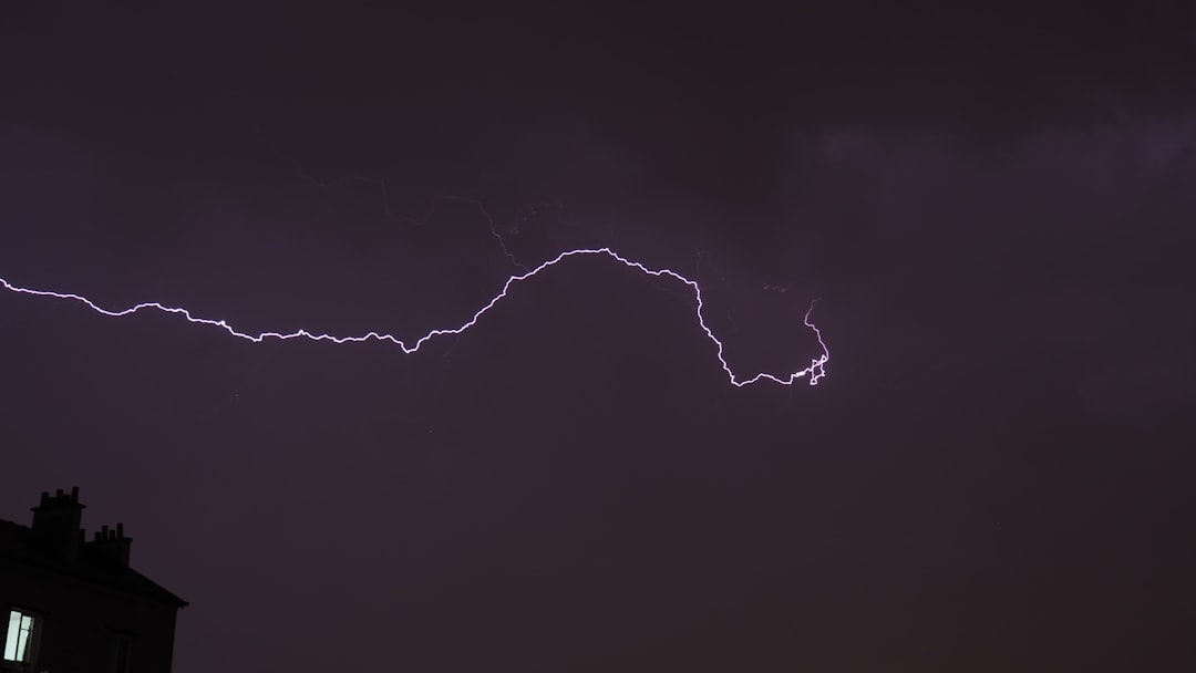
Red Sprites: Lightning’s Mysterious Upper Cousins
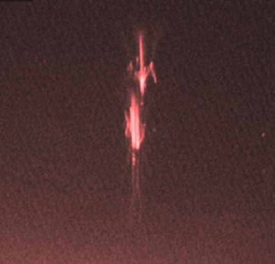
Sprites or red sprites are large-scale electric discharges that occur in the mesosphere, high above thunderstorm clouds, or cumulonimbus, giving rise to a varied range of visual shapes flickering in the night sky. For over a century, these flashes of lightning that shot up from storm clouds, like stories of rains of toads, were dismissed as fiction. Sporadic visual reports of sprites go back at least to 1886. Even when respectable pilots or scientists described them, the scientific community ignored the events.
They were first photographed on July 6, 1989, by scientists from the University of Minnesota and have subsequently been captured in video recordings thousands of times. The most common TLE is a luminous reddish-orange flash directly above large thunderstorms. Sprites flash a fraction of a second after strong lightning strokes, soaring up almost 60 miles high.
Sprites come in three subcategories: jellyfish, column, and carrot (physical characteristics whose names are self-explanatory). They are mostly red, but their ‘tentacles’ transition into blue. These ethereal creatures of the upper atmosphere can stretch up to 60 miles above the Earth’s surface, dancing for mere milliseconds in the thin air where space begins.
Blue Jets: Lightning That Shoots Toward Space
Blue jets are basically just lightning strikes that zip upward from their clouds, rather than down. In the stratosphere, their electricity excites nitrogen to glow blue, giving the jets their signature hue. Unlike their red sprite cousins, blue jets emerge directly from storm cloud tops and rocket upward into the stratosphere like nature’s own fireworks display.
Blue jets emanate upwards from cloud tops at speeds of about 100 km/s (60–90 mi/s) and have a conical shape extending up to around 50 km (30 mi) in altitude, lasting 200 to 300 milliseconds. Small jets that stretch just a few kilometers above their clouds are known as “blue starters.” More powerful versions reach altitudes of about 80 kilometers (50 miles) and are aptly known as “gigantic jets”.
These were taken in a series of 1994 aircraft flights to study sprites. More recently, the source and formation of blue jets has been observed from the International Space Station. The International Space Station provides the perfect vantage point for observing these upward-shooting electrical phenomena that bridge the gap between Earth’s weather and the cosmos.
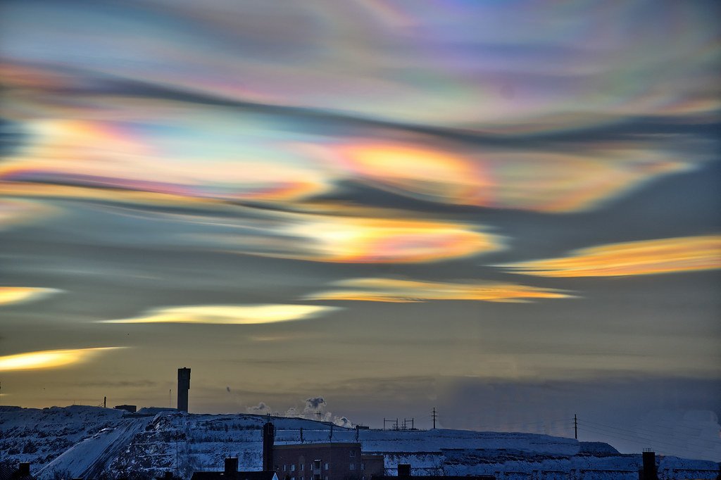
Polar Stratospheric Clouds: Nature’s High-Altitude Light Show
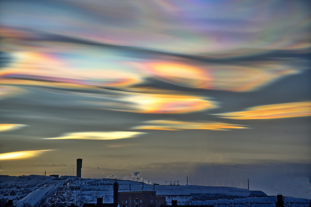
The clouds, known as polar stratospheric clouds (PSC), only form when the lower stratosphere reaches temperatures below minus 114 degrees Fahrenheit (minus 81 degrees Celsius). Normally, clouds do not form in the stratosphere because it is too dry, but at these extremely low temperatures “widely-spaced water molecules begin to coalesce into tiny ice crystals” that form into clouds.
These rare, very high clouds are also known as mother of pearl clouds. They’re a type of polar stratospheric cloud, known to reflect colored light after sunset and before sunrise. As sunlight shines through these crystal clouds, it gets scattered, creating multiple different wavelengths of light, which has inspired the PSCs nickname, “rainbow clouds”.
They are seen mostly during winter at high latitudes like Scandinavia, Iceland, Alaska and Northern Canada. Sometimes, however, they occur as far south as the UK. When these clouds appear, they transform the winter sky into a canvas of iridescent colors that rival the northern lights in their ethereal beauty.
Moonbows: Nighttime Rainbows Cast by Luna’s Light
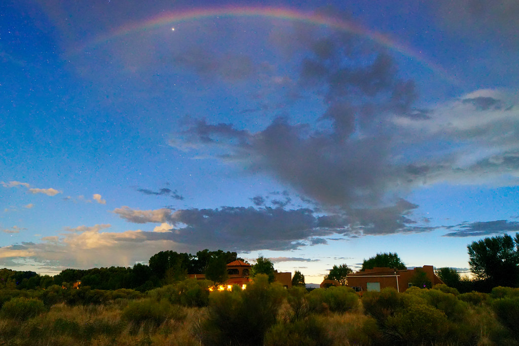
A moonbow is a rainbow produced by moonlight rather than from direct sunlight. Moonbows are usually faint. Because of the faint light usually it becomes difficult for the human eye to discern colors in a moonbow and as a result they often appear to be white. These ghostly arcs appear in the darkness like spectral bridges spanning the night sky.
However, all colors of a moonbow do appear in long exposure photographs. The same physics that creates daytime rainbows applies to moonbows, but the much dimmer moonlight means these phenomena are incredibly rare and require perfect conditions to observe. You need a nearly full moon, clear skies behind you, and rain or mist in front of you.
The best locations to spot moonbows are near waterfalls where mist is constantly present, such as Victoria Falls in Zambia or Yosemite Falls in California. Some dedicated sky watchers travel thousands of miles for the chance to witness these elusive nighttime rainbows that appear only a few nights each month when conditions align perfectly.
Mammatus Clouds: When the Sky Grows Udders
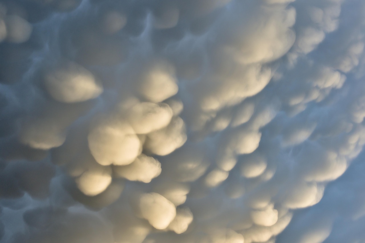
Mammatus comes from the latin “mamelle”. In meteorology, this term refers to circular pockets that form the base of convective clouds such as altocumulus and cumulonimbus. Mammatus color is normally blue-gray, but can take gold or reddish hues when the sun illuminates them. These unusual formations appear as pouches or bulges hanging from the underside of clouds, creating an otherworldly landscape overhead.
Under certain conditions, pockets of clouds can grow and contain ice or heavy rain drops that tend to form water balloons. Such breasts occur in the air near the cloud base. The Mammatus are truly spectacular, especially when the sun illuminates the clouds from below, in raking light.
These formations typically appear after severe thunderstorms when cold, dense air sinks through warmer air below. The result looks like the sky is melting, with bubble-like protrusions creating a surreal ceiling that seems to drip toward the earth. Photographers often describe mammatus displays as some of the most dramatic cloudscapes they’ve ever witnessed.
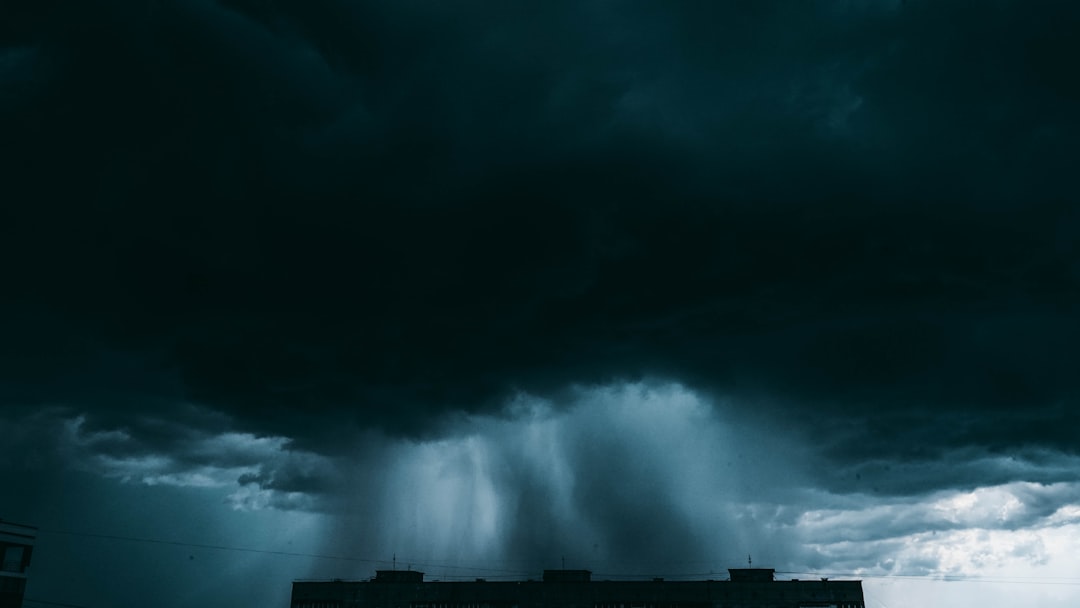
Virga: The Ghost Rain That Never Touches Earth
A virga, also called a dry storm, is an observable streak or shaft of precipitation that evaporates or sublimates before reaching the ground. Virga is ghostly precipitation that never makes it to the ground. When the air beneath a cloud is very dry, precipitation falling through it evaporates before reaching Earth’s surface. What’s left are feathery streaks extending from the cloud’s base, capturing the path the rain or ice took before becoming water vapor.
Virga refers to streams of raindrops, snowflakes, or even halo-forming ice crystals that fall from the clouds but evaporate before reaching the ground. It shows up on radar as a typical rain or snow shower, but there’s no evidence of that at the surface. Great storms could be raging above your head, but the only trace you’ll see are the thin wisps of virga drifting through the sky.
Virga is commonly seen in the Western U.S., desert climates, and other dry areas. These phantom precipitation curtains create some of nature’s most poetic scenes, appearing as delicate veils hanging between heaven and earth, promising rain that never arrives.
Snow Rollers: Nature’s Mysterious Snow Donuts
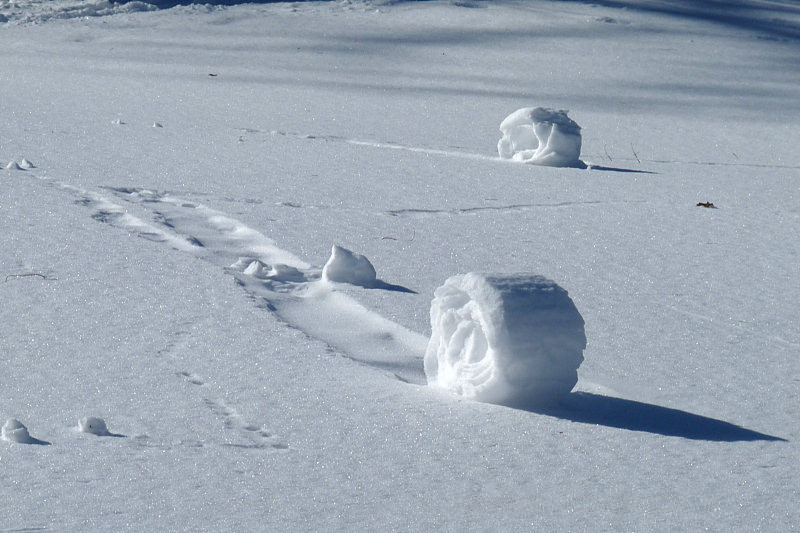
Nature’s recipe for snow rollers, little doughnut-like formations of rolled snow, are no different. These delicate formations need just the right mix of moisture, snow, wind, and temperature. The snow has to be a light dusting, sticky enough to adhere to itself but on a surface that it won’t cling to. The wind has to be strong enough to encourage these mounds of snow to curl up and form their signature loop, but not so strong that the whole thing gets blown apart.
Alternatively, the snow could be on a hill and gently roll downslope to form the same shape. Either way, snow rollers are rare, distinctive finds in nature that are impossible to replicate. These natural snow sculptures appear across fields like giant marshmallows or wheels of snow, often hollow in the center where the original snow clump has blown away.
A field of snow rollers in the southern Idaho Panhandle. The rollers here are about 18 inches tall or more. Finding a field of snow rollers is like discovering a secret art installation created by wind and weather, with each formation perfectly crafted by forces invisible to the human eye.
Asperitas Clouds: When the Sky Becomes an Ocean
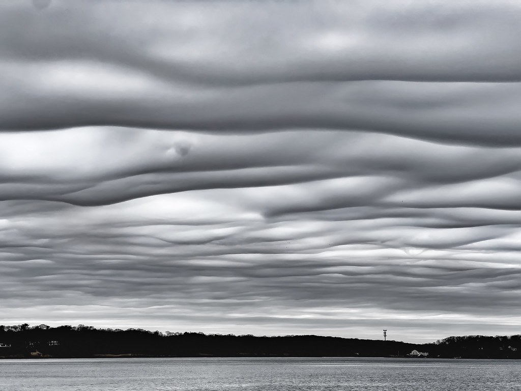
Asperitas was added to the International Cloud Atlas in 2017, making it the first new cloud type in over 30 years, since cirrocumulus undulatus in 1951. It is not yet defined what cloud type gives its home to asperitas, but the WMO began work on deciphering the cloud’s mysteries in 2008. These dramatic formations appear as though ocean waves have been flipped upside down and suspended in the sky.
These clouds form under the same kind of conditions that mammatus form – stable, cool, sinking air around the perimeters of thunderstorms. But in the case of asperitas, winds twist the formations to look like waves, unlike mammatus, which look like bubbles. One theory does suggest that they are formed when mammatus clouds descend into areas of the sky where wind direction changes with height causing the wave-like movement. What is clear however is that atmospheric conditions must be unstable to form a wavy cloud base like that seen with asperitas.
The clouds – asperitas – have only been an “official” cloud for a few months. It’s not that they just started to appear, we just didn’t see them very often until social media made it so easy to share photos. These undulating cloudscapes create the impression that you’re looking up from the ocean floor at waves rolling overhead, turning the entire sky into a turbulent sea frozen in time.
Conclusion
These ten rare weather phenomena remind us that our planet’s atmosphere is far more dynamic and mysterious than we often realize. From glowing plasma orbs that float through homes to ice crystals that paint rainbows in polar skies, nature continues to surprise us with displays that challenge our understanding of what’s possible.
The next time you look up at an ordinary blue sky, remember that extraordinary events unfold regularly in the layers above us. With smartphones making it easier than ever to capture and share these moments, more people are witnessing and documenting these atmospheric marvels. Each photograph and video adds to our collective understanding of these phenomena, turning citizen observers into valuable contributors to meteorological science.
What would you have guessed the atmosphere could create such spectacular shows? Keep your eyes on the sky – you never know when you might witness one of nature’s rarest performances.

Hi, I’m Andrew, and I come from India. Experienced content specialist with a passion for writing. My forte includes health and wellness, Travel, Animals, and Nature. A nature nomad, I am obsessed with mountains and love high-altitude trekking. I have been on several Himalayan treks in India including the Everest Base Camp in Nepal, a profound experience.