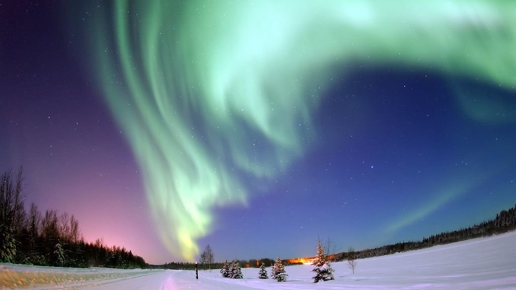
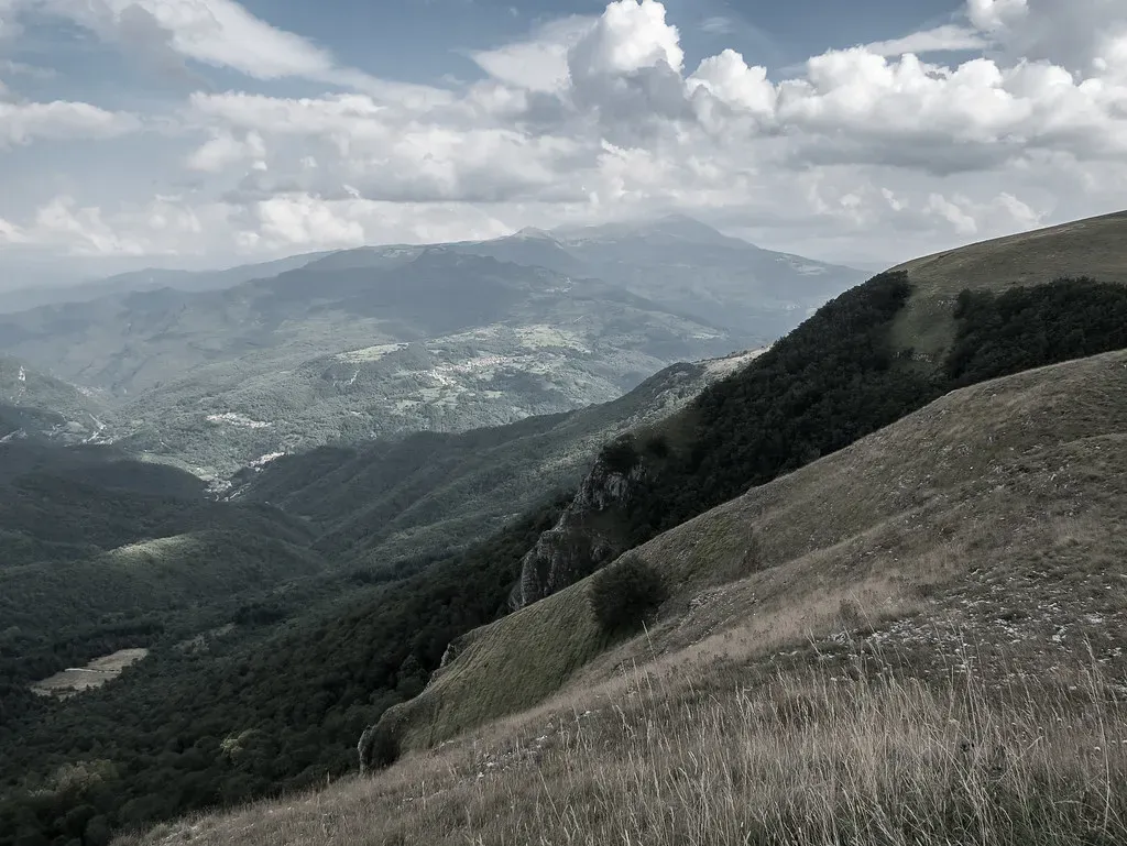
Stand almost anywhere in the United States and the ground under your feet is telling a story. Most of the time, we barely notice it. But scattered across the country are places so dramatic, so strangely beautiful, that it’s impossible not to feel that something enormous and ancient shaped them.
Some of these landscapes were carved grain by grain over hundreds of millions of years. Others were born in violent moments of fire, ice, or flood. Together, they’re like a living time machine, pulling you backward into chapters of Earth’s history so wild they sound made up. Let’s walk through ten of the most astonishing examples – and the hidden forces that built them.
The Grand Canyon: A River That Sliced Open Time
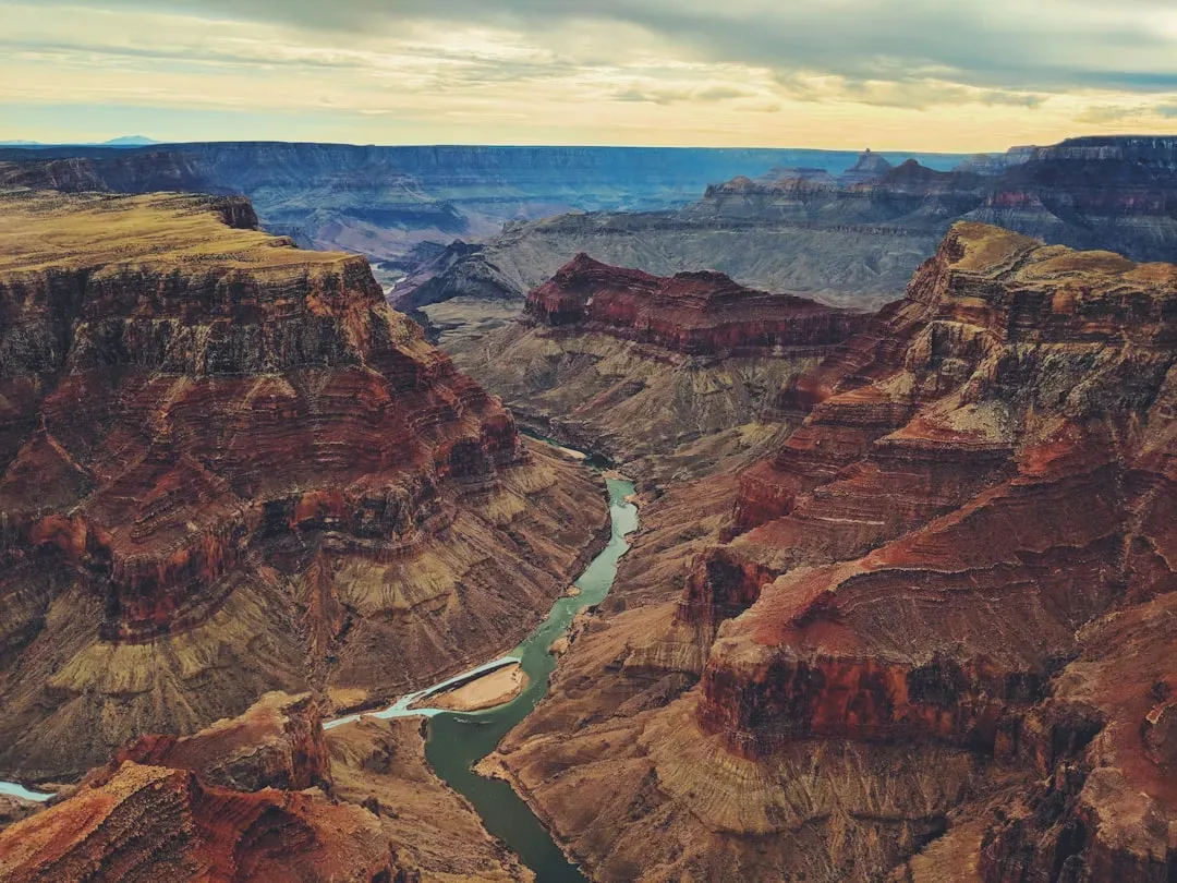
It’s hard to stand on the edge of the Grand Canyon and not feel a little dizzy, and not only because of the height. You’re looking at a chasm that stretches for hundreds of miles, carved mostly by the Colorado River patiently grinding its way downward over roughly the last five to six million years. Layer after layer of colorful rock – reds, creams, purples, grays – tells a stacked story of ancient seas, deserts, swamps, and shorelines laid down over nearly two billion years.
The wild part is that the river didn’t do this alone. Uplift of the Colorado Plateau raised this whole region by thousands of feet, giving the river gravity’s extra help to cut faster and deeper. Wind and rain widened and sculpted the canyon walls, triggering rockfalls and landslides that continue today. When you hike down into the canyon, every switchback is like walking backward in time, from familiar-looking sandstone to deeply buried rocks that formed long before complex life ever crawled out of the ocean.
Yellowstone: A Supervolcano Hiding in Plain Sight
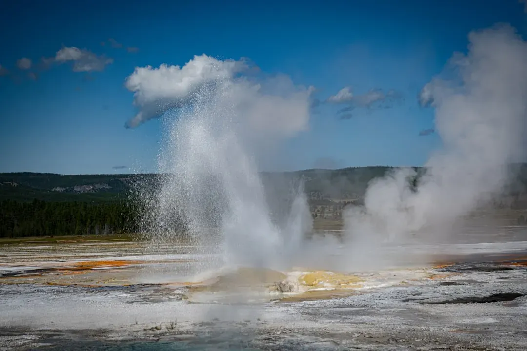
Yellowstone looks, at first glance, like a regular high mountain park: forests, rivers, elk grazing in meadows. Then the ground starts steaming, geysers roar to life, and boiling mud bubbles like a pot on the stove. All of this drama sits on top of one of the most powerful geologic engines on Earth – a massive hotspot of rising magma that has fueled gigantic volcanic eruptions in the past.
Instead of one big cone-shaped volcano, Yellowstone is a huge caldera, a collapsed volcanic basin roughly the size of a small state. Over the last couple of million years, there have been several colossal eruptions that spread ash across much of North America. Today, heat from the still-active magma chamber drives an enormous hydrothermal system: water seeps down, heats up, and blasts back to the surface as geysers, hot springs, and fumaroles. Walking the boardwalks, you’re literally on top of a restless, slowly breathing supervolcano – not in a Hollywood disaster way, but in a constant, quietly powerful way.
Hawaiian Volcanoes: Islands Born from a Moving Plate
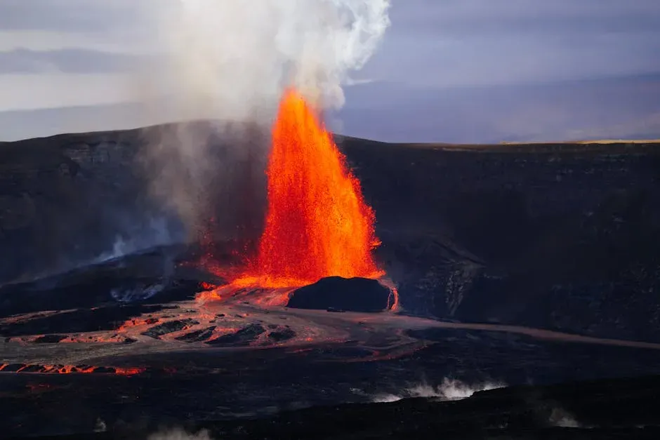
The Hawaiian Islands are like a slow-motion conveyor-belt experiment in the middle of the Pacific. A stationary mantle hotspot sends up molten rock, while the Pacific Plate drifts over it at the pace your fingernails grow. Each time the plate moves a little, a new volcano can rise from the seafloor, eventually breaking the surface to become an island. That’s why the islands form a chain, oldest to the northwest and youngest, like Hawaiʻi Island, to the southeast.
On the Big Island, you can literally see land being born. Basaltic lava flows from vents and fissures at Kīlauea and Mauna Loa, sometimes moving quietly in glowing rivers, sometimes building new black sand beaches overnight. Over hundreds of thousands of years, erosion gnaws away at these volcanic mountains, carving deep valleys and sea cliffs like those on Molokaʻi and Kauaʻi. The whole chain is a time-lapse of construction and destruction, with the next island – submarine volcano Kamaʻehuakanaloa – already rising in the darkness a few thousand feet below the surface.
Yosemite Valley: Granite Sculpted by Ice
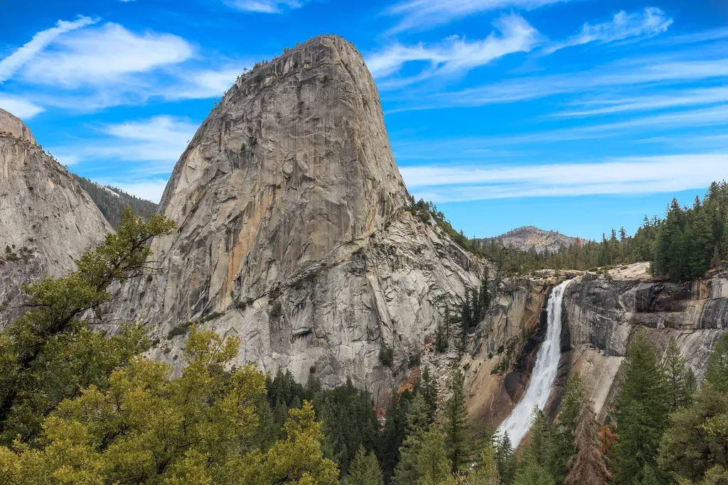
Yosemite Valley looks almost unreal, with its sheer granite walls and waterfalls that seem to drop straight from the sky. Those vertical cliffs and U-shaped valley weren’t carved by the Merced River alone. They are the signature of glaciers, thick rivers of ice that filled and scraped out the valley repeatedly during the last couple of million years. Before the ice, this was a more ordinary V-shaped river valley; the glaciers bulldozed it into something iconic.
The granite itself formed far below the surface as magma cooled slowly, allowing large crystals to grow. Over time, uplift and erosion stripped away the overlying rock, unveiling massive sculpted domes like Half Dome and smooth walls like El Capitan. The glaciers plucked huge blocks from the valley sides and polished the bedrock, leaving behind striations and perched boulders. When you look up at those clean, bright rock faces, you’re really seeing the bones of an ancient magma chamber, sanded and shaped by ice that has long since vanished.
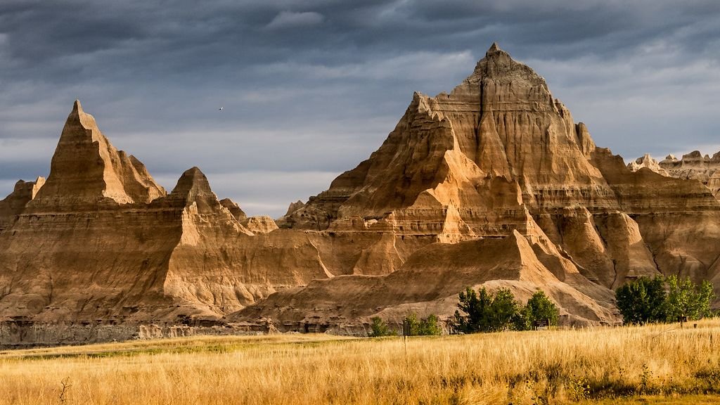
Badlands of South Dakota: Erosion in Fast-Forward
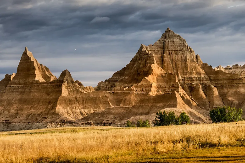
The Badlands feel like a broken dreamscape: sharp ridges, jagged buttes, and striped hills rising suddenly from open prairie. This landscape is young in geologic terms and shockingly fragile. Soft layers of sedimentary rock – mudstone, siltstone, volcanic ash, and sandstone – were laid down in ancient rivers, lakes, and floodplains over tens of millions of years when the region teemed with early horses, rhinos, and other strange mammals.
Now erosion is tearing it all apart at a sprint. Wind, rain, and seasonal freeze-thaw cycles chew into the soft rock, carving gullies and spires and revealing fossil-rich layers at a pace scientists can actually measure over a human lifetime. In some places, the Badlands retreat by inches every year. It’s like watching a sculpture made of sugar slowly melt in the rain, except here the disappearing shapes are revealing a detailed record of life and climate on the ancient Great Plains.
Everglades: A River That Flows Almost Too Slowly to See
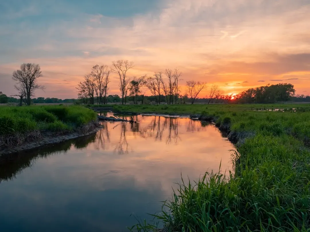
The Everglades might look like a giant swamp from above, but geologically, it’s really an incredibly shallow, slow-moving river sprawling across a vast limestone platform. Rainwater and overflow from Lake Okeechobee spread southward in a sheet, flowing so gently that plants have time to grow thickly in its path. That interaction between flat topography, porous bedrock, and subtropical climate built one of the most unique wetlands on Earth.
Under the grasses and mangroves lies limestone formed from ancient marine organisms when this region was a shallow sea. Over time, slight changes in sea level and subsidence shaped the basin that holds today’s marshes. The water’s movement is the quiet architect here, carving subtle channels, building peat, and creating habitat mosaics for alligators, wading birds, and sawgrass. When you realize you’re standing in a river that moves barely more than a few hundred feet a day, the whole place feels like time itself has slowed down.
Great Sand Dunes: Mountains of Moving Grains
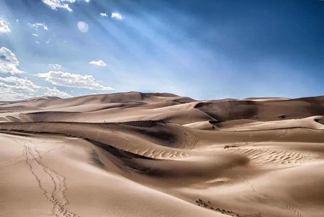
In southern Colorado, sand has piled up into dunes that tower higher than many skyscrapers, backed by the jagged Sangre de Cristo Mountains. At first, it almost feels like a desert dropped in the wrong place. These dunes, however, are the result of a very specific and persistent set of wind patterns working with a closed basin where sand gets trapped instead of blown away. Over thousands of years, winds funneled through mountain passes have pushed sand up against the mountains, stacking it higher and higher.
The sand itself mostly comes from the erosion of nearby mountains and ancient lake beds in the San Luis Valley. Streams at the base of the dunes, like Medano Creek, carry sand back out, where the wind picks it up and returns it to the main dune field – a natural recycling system. The dunes are still migrating and reshaping with every strong gust, forming steep slip faces, ripples, and booming dunes that can vibrate and hum under just the right conditions. Climbing them, you feel every step slide backward as if the landscape is politely resisting your attempt to conquer it.
Carlsbad Caverns: An Underground World Etched by Acid
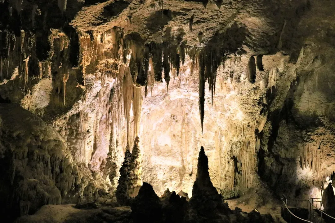
On the surface, the Guadalupe Mountains of New Mexico look like rugged desert hills. Beneath them lies a completely different universe: Carlsbad Caverns and a maze of related caves, some of the largest and most decorated in the world. Unlike many limestone caves that form purely from carbonic acid in rainwater, these chambers were also carved by sulfuric acid generated when hydrogen sulfide from ancient petroleum deposits met oxygenated groundwater. That extra chemical punch allowed enormous rooms to form deep underground.
After the cavities were created, dripping water began slowly decorating them with stalactites, stalagmites, columns, and delicate formations that look like curtains, soda straws, and even popcorn. Each mineral deposit is the result of countless drops of mineral-rich water leaving behind a microscopic trace of calcite. Over hundreds of thousands of years, those traces grew into shapes that feel almost alien. Walking into the Big Room, with its towering formations and shadowy corners, is like stepping into the lungs of the Earth, where the rock itself seems to be mid-breath.
Denali and the Alaska Range: Mountains Thrust Toward the Sky
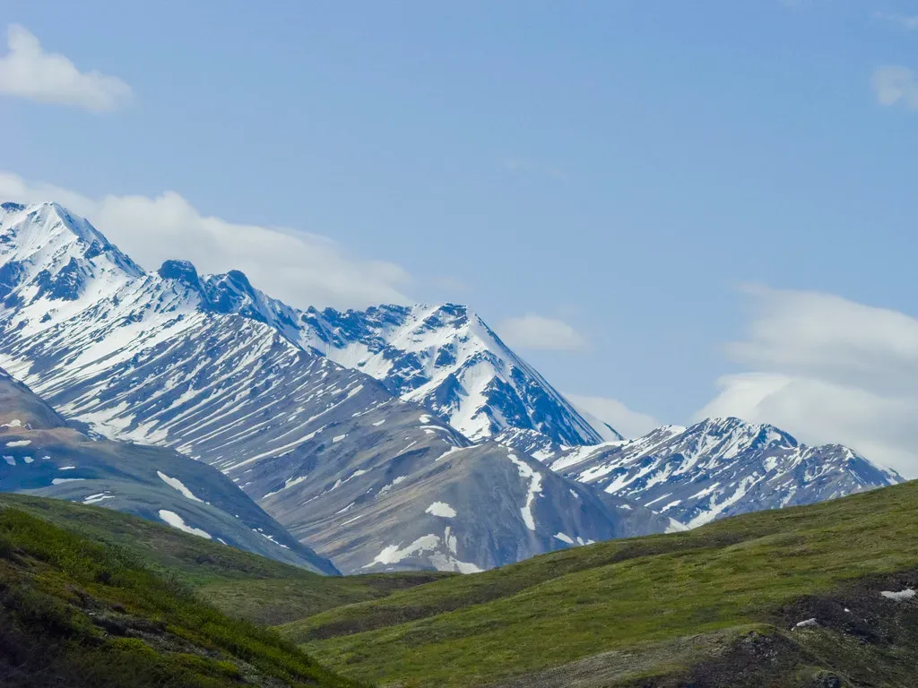
Denali, the highest peak in North America, doesn’t just look tall; it looks defiant. The mountain and its surrounding range exist because tectonic plates are colliding along Alaska’s southern edge, crumpling and stacking the crust into some of the steepest relief on the continent. In some places, the vertical rise from lowland valley floors to the summits is greater than the height difference between sea level and the top of Mount Everest when measured straight up.
The forces at work here are immense. As the Pacific Plate grinds under the North American Plate, compressional stresses shove rock upward while also fracturing and faulting it. Glaciers then slice into these rising peaks, carving sharp ridges, cirques, and deeply incised valleys filled with creaking, bluish ice. The result is a landscape that feels raw and unfinished, as if the mountains were pushed up yesterday and have barely had time to catch their breath. Even in summer, the mix of rock, ice, and cloud makes it obvious you’re standing in a place still being built.
Crater Lake: A Volcano That Collapsed into Itself
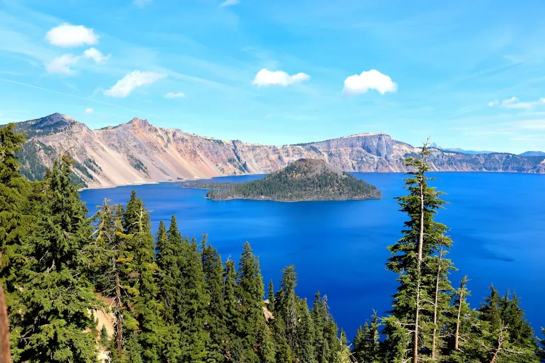
Crater Lake in Oregon looks impossibly blue, a perfect circle of water tucked inside steep cliffs with a whimsical island rising from its center. That stillness is hiding a violent origin story. About seven and a half thousand years ago, the volcano known as Mount Mazama erupted so explosively that its summit region collapsed into the emptied magma chamber below, creating a huge caldera. Over time, snow and rain filled this basin, forming one of the deepest lakes in the United States.
The lake has no major rivers flowing in or out; its water level is maintained mostly by a balance of precipitation and evaporation, which helps explain the remarkable clarity and rich blue color. Wizard Island, near one edge, is a later volcanic cone that grew after the main collapse. Under the surface, rugged lava domes and steep underwater walls hint at the chaotic reshaping that followed the eruption. Standing at the rim, it’s sobering to realize that what looks like a tranquil alpine lake is actually the quiet, water-filled scar of a collapsed volcano.
Conclusion: A Restless Country Under Our Feet
From the quiet flow of the Everglades to the towering face of Denali, the United States is stitched together by landscapes born from collision, collapse, erosion, and eruption. Some forces work so slowly that entire civilizations rise and fall before the changes are obvious; others reshape whole regions in a matter of days or hours. Either way, the ground we treat as solid and permanent is constantly shifting, sinking, rising, and rearranging itself behind the scenes.
Once you start to see these places as the visible fingerprints of deep time, road trips and park visits stop being just sightseeing and become something closer to reading a very old, very dramatic book. You notice the tilt of a rock layer, the curve of a valley, the sudden appearance of steam or sand, and you know there’s a story humming under the surface. The next time you’re standing at the edge of a canyon or watching a geyser breathe, it’s worth asking yourself: if this is just one page in Earth’s history, how many chapters are still waiting to be written?