Walk across certain hillsides in the Americas and you’re treading on top of arguments that have divided archaeologists for decades. Beneath grassy mounds, in forgotten canyons, and under suburban parking lots lie ruins that seem to whisper a different version of early history than the one many of us learned in school. For a long time, the popular story was simple: small bands of recent arrivals, spreading slowly, building modest villages at best. Yet again and again, the ground keeps yielding evidence of cities, astronomers, engineers, and long-distance traders operating thousands of years ago. The real mystery now is less about whether these civilizations existed and more about why it took us so long to recognize how complex, connected, and innovative they really were.
The Hidden Clues: Watson Brake and a Civilization That Came Too Early
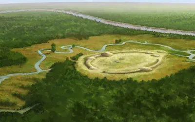
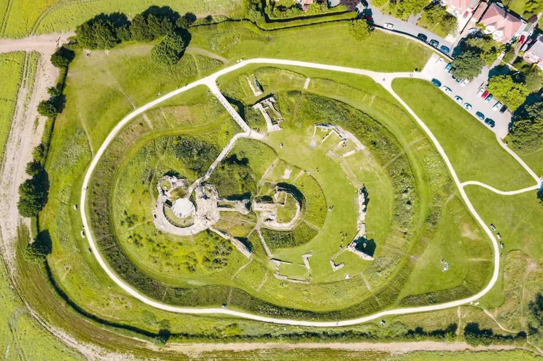
On a low terrace above the Ouachita River in northern Louisiana, a set of eleven earthen mounds forms an oval that looks almost unimpressive from the ground. From the air, though, Watson Brake resolves into a carefully planned architectural statement, built and rebuilt roughly about 5,000 years ago, long before the pyramids of Giza were finished. For decades, local residents knew the mounds were there, but few suspected they might represent the oldest known large-scale earthwork complex in North America. Radiocarbon dates forced archaeologists to admit that sophisticated mound-building societies existed in the Lower Mississippi Valley much earlier than expected. That timing alone rattled the neat timeline that said monumental architecture appeared only with settled farming.
Watson Brake’s builders were still primarily hunter-gatherers, moving through rich wetland ecosystems rather than living in dense cities, which clashes with the old assumption that only farmers build big. The site suggests careful planning over centuries, coordinated labor, and shared ideas about space and ritual that went far beyond simple seasonal camps. Layers of soil show repeated construction phases, implying a long memory and cultural continuity anchored to that place. There’s no written record, no stone temples, and no golden artifacts – just earth moved by human hands on a staggering scale. Yet it quietly signals that complexity, hierarchy, and shared cosmologies were already taking root in the Americas thousands of years earlier than many textbooks once implied.
Cahokia’s Forgotten Skyline: A Lost North American City
Just across the Mississippi River from modern St. Louis, traffic roars past what was once the beating heart of the largest pre-Columbian city north of Mexico. Known today as Cahokia, this urban center flourished around one thousand years ago, with a population comparable to or exceeding the biggest European cities of its time. Monks Mound, the colossal earthen platform at its core, rises taller than a ten-story building and would have dominated a skyline of plazas, wooden temples, and residential neighborhoods. When I first stood at the top, looking out over interstate highways and utility lines, it felt like staring at a ghost city hiding in plain sight. The shock is not that Cahokia existed, but that so few people outside archaeology know it did.
Excavations have revealed evidence of complex social stratification, large-scale food storage, and a web of trade that extended hundreds of miles. Artifacts made of copper, marine shell, and exotic stones point to networks connecting the Great Lakes, the Gulf Coast, and the interior plains. Archaeologists have also identified a wooden “Woodhenge” circle, aligned with solstices and equinoxes, suggesting a deep astronomical awareness woven into civic life. Yet by the time Europeans arrived in the region, Cahokia had already collapsed, leaving only scattered memories and eroded mounds. The ruins confront us with a hard question: how did a city of this scale emerge and then vanish so thoroughly that it barely registers in mainstream historical imagination?
Geometry in the Grass: The Enigmatic Earthworks of the Ohio Valley
In southern Ohio, ancient geometry is carved into the landscape at a scale that defies easy explanation. At sites like Newark and the now-mostly-destroyed earthworks in Chillicothe, immense circles, squares, and octagons of raised earth once traced precise shapes over many hectares. Early surveyors in the nineteenth century painstakingly mapped these forms, and modern researchers later discovered that some alignments track lunar standstills – rare positions of the moon that repeat only over long cycles. That means the builders were not only engineers but also patient sky-watchers, tracking celestial patterns over generations. It is hard not to picture teams of people using cords, stakes, and sightlines the way an architect uses blueprints.
What makes these ruins so unsettling is how much intentionality they imply in societies long dismissed as simple woodland villagers. The earthworks often required moving enormous quantities of soil and maintaining clear lines of sight that stretched over natural hills and rivers. Many were connected by earthen avenues and may have been used for rituals, seasonal gatherings, or processions that turned the landscape into a kind of living calendar. At Newark, the precise ratio between different shapes has led some researchers to argue for a shared unit of measurement used across the complexes. These designs challenge the idea that advanced geometry and astronomical planning were the exclusive domain of Old World civilizations.
Desert Lines and Buried Cities: From Chaco Canyon to Caral
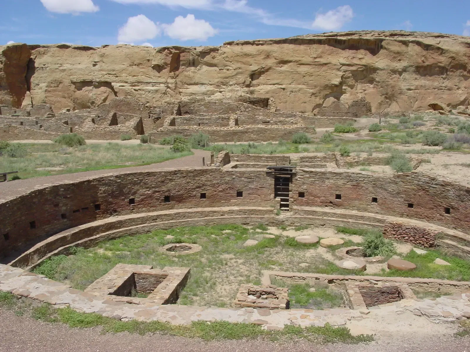
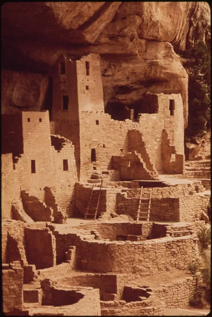
Travel west and south and the pattern of puzzling ruins becomes even more pronounced. In New Mexico’s Chaco Canyon, massive stone “Great Houses” like Pueblo Bonito and Chetro Ketl rise from the desert, some with hundreds of rooms arranged in intricate D-shaped plans. Roads engineered with unnerving straightness run out from the canyon, slicing across mesas and cliffs as if obeying some larger geometric logic. Farther south, in coastal Peru, the city of Caral stands as one of the oldest known urban centers in the Americas, with platform mounds, sunken plazas, and evidence of complex social organization dating back nearly five thousand years. When these sites are considered together, they draw a picture of enduring traditions of large-scale building and regional planning spanning millennia.
Caral’s age rivals, and in some ways predates, early urban developments in Egypt and Mesopotamia, publicizing the idea that civilization did not have a single heartland but multiple co-evolving centers. Chaco, meanwhile, shows how a society without metal tools or draft animals could still quarry, move, and stack vast quantities of sandstone with remarkable precision. Both sites point to sophisticated knowledge of resource management, trade, and ritual architecture. They also expose a blind spot: for a long time, research attention and public fascination leaned heavily toward Old World ruins, leaving American sites underfunded and underpublicized. As new dating techniques and regional surveys accumulate, it is becoming harder to argue that early history in the Americas was somehow a simpler side story.
Ruins Underfoot: Poverty Point, Serpent Mound, and the Surprise of Scale
In northeastern Louisiana, near the Mississippi floodplain, the site of Poverty Point looks at first like a confusing set of low ridges and mounds. Viewed from above or mapped with modern instruments, those ridges resolve into six enormous concentric arcs, with additional mounds and causeways radiating outward. This entire complex, built roughly three thousand years ago, required moving millions of basket-loads of soil, all without the help of wheeled vehicles or beasts of burden. For years, I thought of hunter-gatherers as people traveling light, leaving only faint traces behind, yet Poverty Point flips that idea on its head. It is like finding out a group of campers secretly built an amphitheater between weekend trips.
Similarly, Ohio’s Serpent Mound coils along a ridge in an undulating earthen snake more than a thousand feet long, its open mouth encompassing an egg-shaped mound. Debates about its exact age continue, but many researchers now argue for a construction date associated with the Fort Ancient culture around a thousand years ago. The form is so graceful and so large that it is almost impossible to appreciate from ground level; it truly makes sense only from above, as if designed for an audience in the sky. Both Poverty Point and Serpent Mound hammer home a point that is easy to miss: Indigenous North American societies were not only capable of monumental projects, they repeatedly chose to reshape entire landscapes in symbolically rich ways. The surprise here is not just the engineering, but the audacity of the ideas those earthworks embody.
From Ancient Tools to Modern Science: How New Methods Are Rewriting the Story
Many of these “strange” ruins were hiding in plain sight, but we simply lacked the tools – or, more honestly, the curiosity – to read them properly. Over the last two decades, technologies like lidar (airborne laser scanning), high-resolution satellite imagery, and refined radiocarbon dating have started to peel back forest canopies and floodplain sediments. Lidar in particular has been a revelation: by stripping away vegetation in digital models, it reveals ancient terraces, causeways, and mounds that would be invisible to a person walking the ground. Archaeologists working in the Amazon and Mesoamerica have suddenly found sprawling settlement systems where earlier maps showed only isolated sites. The result feels a bit like turning up the contrast on a photograph and realizing there was an entire crowd standing in the shadows.
These tools also let researchers revisit older sites with fresh questions. Subtle differences in soil chemistry can hint at ancient gardens or plazas; microscopic wear on tools can distinguish between cutting reeds and scraping hides. When scientists combine these data sets, the picture that emerges is far more dynamic than the static “lost ruin” narrative. Cities grew, shrank, and reoriented; trade routes shifted; rituals evolved. The ruins are not isolated anomalies, but part of long-lived, interconnected systems that rose and fell much like those in Eurasia. Modern science is not just filling in details, it is challenging the assumption that American prehistory was a quiet prelude waiting for European records to begin the “real” story.
Why It Matters: Challenging Old Narratives About “Simple” Societies
It might be tempting to treat these sites as curiosities, the archaeological equivalent of odd roadside attractions, but they sit at the heart of a much bigger reckoning. For generations, many histories framed Indigenous societies in the Americas as static, small-scale, and technologically limited, especially north of Mexico. Those assumptions conveniently supported colonial myths that the land was lightly used or underdeveloped, and therefore available for the taking. When we learn that vast regions were laced with engineered fields, roads, mounds, and cities, the moral landscape shifts as sharply as the physical one. The ruins testify to experiments in governance, cosmology, and environmental management that deserve to be taken as seriously as those of Greece, Egypt, or China.
From a scientific standpoint, recognizing the sophistication of these cultures broadens the sample size for understanding how complex societies work. Patterns like rapid urban growth, ecological strain, social inequality, and eventual collapse appear in Cahokia and Chaco just as they do in other world civilizations. Studying these examples helps archaeologists and historians test ideas about resilience, adaptation, and failure under different environmental and technological conditions. It also re-centers Indigenous knowledge, showing that local oral traditions and ecological practices are rooted in very long histories of living in these landscapes. In other words, taking the ruins seriously forces us to take their descendants seriously too, not as background characters in someone else’s history but as inheritors of deep intellectual traditions.
Global Perspectives: The Americas as a Co-Equal Cradle of Complexity
For much of the twentieth century, the story of civilization was often told as a kind of relay race starting in the Fertile Crescent and passing through a few familiar waypoints. The ruins of the Americas, especially those that push back dates or reveal advanced planning in unexpected places, crack that narrative open. Sites like Caral, Poverty Point, and the Ohio earthworks demonstrate that urbanism, monumental ritual spaces, and scientific observation arose independently in multiple parts of the world. When you step back, it becomes harder to argue for a single template of progress and easier to see parallel experiments unfolding under different skies. The Americas were not latecomers; they were co-authors of the human story from the beginning.
This global reframing has practical consequences for research and funding. When archaeologists treat American sites as peripheral, field projects are smaller, surveys are patchy, and whole regions remain underexplored. As that changes, we are starting to see more collaborative work between Indigenous communities, local governments, and international research teams. There is a growing recognition that understanding climate adaptation, resource management, and social organization in the past can inform policy debates today. In that sense, every new lidar map or refined radiocarbon date is not just a footnote to prehistory – it is a data point in a living conversation about how societies, everywhere, confront the limits of their environments.
The Future Landscape: Technologies, Threats, and What We Might Still Find
Looking ahead, the strangest thing about the ruins of the Americas may be how many of them we still have not identified. Advances in remote sensing, machine learning, and environmental reconstruction are turning whole continents into searchable archives. Algorithms can now scan vast swaths of satellite imagery for telltale rectilinear patterns or subtle elevation changes that hint at buried structures. As computing power grows and datasets expand, there is a real possibility that we will discover extensive settlement systems in places once dismissed as untouched wilderness. Dense forests, swamps, and even urbanized areas could be concealing layers of past infrastructure waiting to be recognized.
At the same time, these sites face an accelerating list of threats. Urban sprawl, industrial agriculture, looting, and climate-driven erosion are destroying contexts faster than archaeologists can document them. In some regions, roughly about one third to nearly half of known sites show signs of disturbance or damage. Rising sea levels threaten coastal shell mounds and villages; intensified storms wash out fragile adobe walls and earthworks. The future of research will hinge not just on new tools, but on new partnerships that prioritize protection and ethical collaboration with descendant communities. What we save – or fail to save – over the next few decades will shape how complete our picture of early American history can ever be.
Conclusion: How Curious Readers Can Help Protect the Past
The good news is that you do not need a trowel or a PhD to play a role in this unfolding story. One simple step is to seek out and visit local Indigenous and archaeological sites, from small mound parks to regional museums, and actually read the interpretive signs rather than treating them as background scenery. Supporting organizations that work with descendant communities on preservation – whether through donations, memberships, or volunteering – helps give those groups the resources and leverage they need. Even talking about places like Cahokia or Poverty Point in everyday conversations pushes them closer to the center of public awareness, where they belong. Awareness may sound like a soft action, but in heritage politics, what people know and care about often dictates what gets saved.
You can also be a better steward by treating the landscape itself as a fragile archive. That means resisting the temptation to pocket artifacts on hikes, reporting looting or vandalism when you see it, and respecting restrictions on access to sacred sites. Educators can weave these stories into classrooms, not as side notes but as core chapters in the history of science, engineering, and city-building. And if you are the kind of person who enjoys poring over maps or open-source satellite imagery, community science projects increasingly welcome digital volunteers to help flag potential features for follow-up. The ruins that challenge our old stories about early history are still out there, and whether they are preserved, understood, and remembered will depend in no small part on what curious readers choose to do next.

Suhail Ahmed is a passionate digital professional and nature enthusiast with over 8 years of experience in content strategy, SEO, web development, and digital operations. Alongside his freelance journey, Suhail actively contributes to nature and wildlife platforms like Discover Wildlife, where he channels his curiosity for the planet into engaging, educational storytelling.
With a strong background in managing digital ecosystems — from ecommerce stores and WordPress websites to social media and automation — Suhail merges technical precision with creative insight. His content reflects a rare balance: SEO-friendly yet deeply human, data-informed yet emotionally resonant.
Driven by a love for discovery and storytelling, Suhail believes in using digital platforms to amplify causes that matter — especially those protecting Earth’s biodiversity and inspiring sustainable living. Whether he’s managing online projects or crafting wildlife content, his goal remains the same: to inform, inspire, and leave a positive digital footprint.