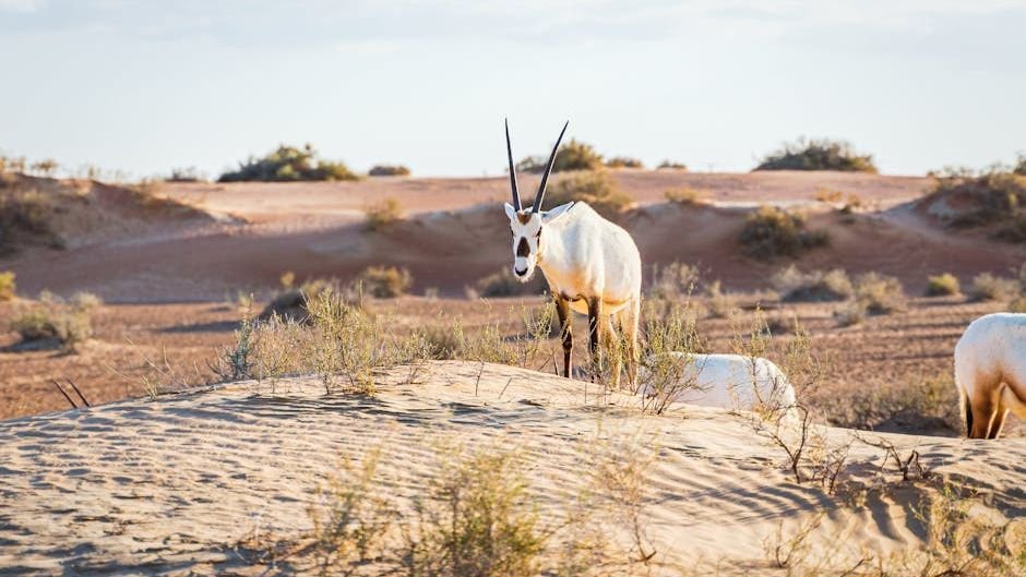
There is something almost otherworldly about standing in front of a rock formation that has been shaped over millions, sometimes billions, of years. You are not just looking at stone. You are reading a page from the longest book ever written, one authored by volcanic fury, grinding ice, relentless water, and the slow, unstoppable drift of continents. Every ridge, stripe, and column is a sentence in that story.
What makes geology so endlessly fascinating is how personal it feels once you understand what you are actually looking at. These are not just pretty landscapes to photograph and post online. They are time capsules, confessions, and records of events so vast they make human history seem like a footnote. So let’s get started, because what Earth has left behind is far more dramatic than anything you might expect.
1. The Giant’s Causeway, Northern Ireland: Where Legend Meets Lava
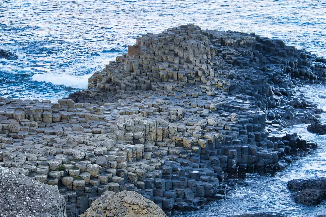
Here is something that will genuinely stop you in your tracks. This geological wonder consists of around 40,000 interlocking basalt columns that resemble a grand mosaic or a giant pathway leading into the sea. When you first see it in photographs, your brain instinctively doubts that nature could have produced something so geometrically precise. It almost looks like a tiled floor designed by an architect with an obsession for hexagons.
The formation of the Giant’s Causeway dates back approximately 50 to 60 million years to a period of intense volcanic activity. As lava from volcanic eruptions cooled and solidified, it contracted and cracked, creating the distinctive hexagonal columns. Think of it like this: imagine a massive puddle of mud drying under an incredibly hot sun, cracking into neat polygons. Now scale that image up to the size of a coastline, and you have a rough idea of what happened here. It is a UNESCO World Heritage Site and a popular tourist destination.
2. The Grand Canyon, USA: A Mile-Deep Library of Earth’s History
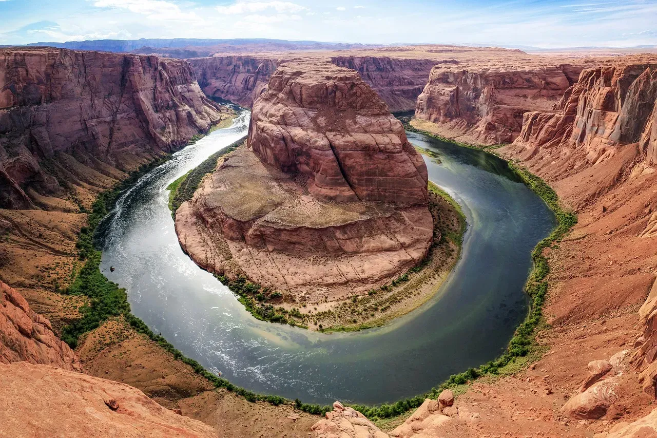
Sedimentary rocks tell perhaps the most comprehensive story of Earth’s history, as they record characteristics of far-away mountain ranges, river systems that transported the sediments, and the final environment in which the sediments accumulated. Nowhere on Earth is this more dramatically visible than at the Grand Canyon. You can stand at the rim and literally look down through layer after layer of geological time, each stripe of color representing a different era, a different world.
The Grand Canyon also contains what is known as the Great Unconformity, a huge gap in the geological record where layers of rock dating from about 1.2 billion to 250 million years ago are completely missing from certain areas around the globe. This enormous chunk of lost time can be seen clearly in the stratigraphy of the canyon in Arizona. Honestly, that gap is what gets me. We are looking at a place where hundreds of millions of years of history simply vanished, likely erased by ancient glaciers that scoured the planet clean during what scientists call “Snowball Earth.”
3. Uluru, Australia: The Sacred Monolith That Changes Color
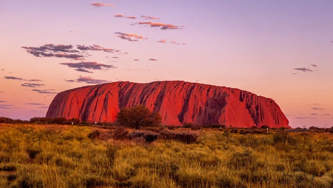
Uluru is one of the most important Aboriginal sites on the continent and an icon of Australia. Its colour appears to change over the course of the year, the months, and the days. At sunset and sunrise, it glows an awe-inspiring rust red. You might have seen photos and still not quite believed them. The shifting palette of oranges, purples, and crimson hues is caused by the way the iron-oxide-rich sandstone surface catches and reflects different angles of sunlight. It is like watching a slow, ancient performance that has been going on for eons.
Located in the Northern Territory, this sacred sandstone rock formation is one of the world’s largest monoliths, having a height of more than 318 metres, or nearly 1,000 feet. In the land all around Uluru can be found life-giving springs and waterholes, rock caves, and ancient paintings. It is not just a geological marvel. It is a cultural heartbeat, a place where deep time and deep culture meet in a way that few places on Earth can replicate.
4. The Eye of the Sahara (Richat Structure), Mauritania: Nature’s Bullseye
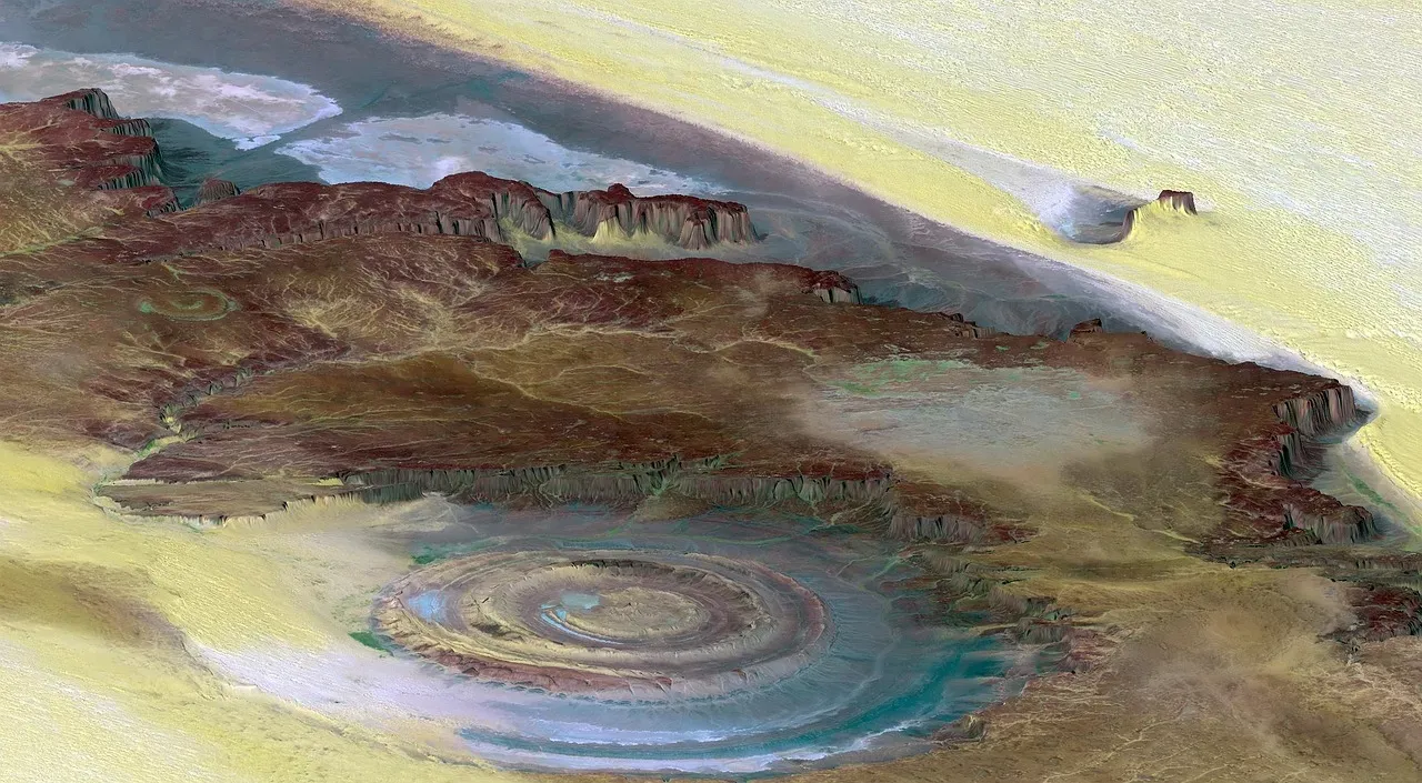
The Eye of the Sahara, also known as the Richat Structure, is a 28-mile-wide site of huge concentric circles found in the western African nation of Mauritania. Geologists initially thought the site was created by an asteroid impact, but there isn’t enough melted rock among the rings to support this theory. It is the kind of place that, when you see it from space, makes you feel like the Earth has been staring back at you all along. From a satellite, it looks almost too perfect, too deliberate, like something carved intentionally.
More recently, geologists have proposed that the Eye of the Sahara could be an eroded, collapsed geological dome, formed some 100 million years ago when the supercontinent Pangea broke up. Bolstering this theory are ancient rocks found on the surface, which originated as much as 125 miles beneath the Earth’s crust. Let’s be real: a structure that brings rocks from 125 miles underground to the surface is barely comprehensible. It is a reminder that the forces beneath your feet are enormously, almost terrifyingly, powerful.
5. Bryce Canyon, USA: A Forest of Stone Spires
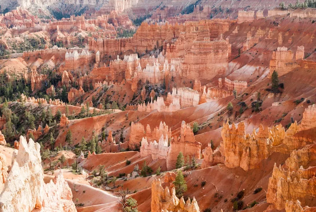
Bryce Canyon, located in Utah, is a breathtaking and unique geological wonder that mesmerizes visitors with its intricate rock formations and vibrant colors. Despite its name, Bryce Canyon is not actually a canyon but rather a collection of natural amphitheaters carved into the eastern edge of the Paunsaugunt Plateau. The most distinctive feature of Bryce Canyon is its hoodoos – tall, thin spires of rock that protrude from the amphitheaters. Standing inside one of these amphitheaters is a surreal experience, like being surrounded by a crowd of ancient, silent sentinels.
Water from rain or melted snow seeps into cracks along the crater rims and expands as it freezes overnight, before thawing again as temperatures climb. This freeze-thaw cycle is repeated until eventually the rock breaks. Slightly acidic rain falling onto the limestone and calcium carbonate also eats away at weaker rocks, while stronger rocks remain untouched, enhancing the dramatic shapes. Bryce Canyon is home to the world’s largest hoodoo field. That is not a small claim. It means nowhere else on the planet has nature carved this many of these remarkable spires into a single landscape.
6. Pamukkale, Turkey: Earth’s White Cascading Terraces
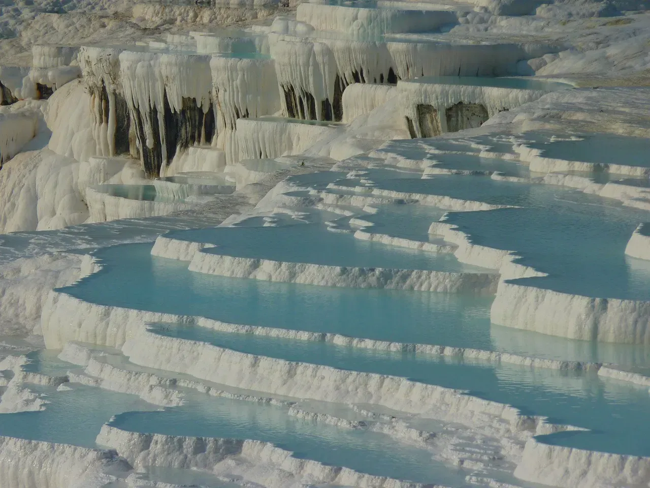
These white calcium carbonate terraces filled with thermal waters look like a giant’s wedding cake or natural infinity pools. The name Pamukkale means “cotton castle” in Turkish, and it’s easy to see why. You walk toward it and genuinely wonder if someone poured white paint down the hillside. The visual effect is jarring in the most beautiful way imaginable, like a waterfall that decided to freeze itself mid-motion and stay that way forever.
The terraces formed when calcium-rich thermal waters cascaded down the hillside, cooling and depositing calcium carbonate in a process that has been ongoing for thousands of years. Ancient Romans built the city of Hierapolis at the site to take advantage of these natural spa pools. It is hard to say for sure how much the Romans understood about the geology behind what they were soaking in, but they clearly recognized that something extraordinary was happening here. Civilizations don’t build cities next to mediocre places.
7. The Wave, Arizona: A Frozen Desert Ocean
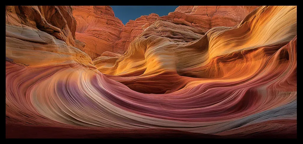
Hidden in Arizona’s Vermilion Cliffs National Monument, this undulating sandstone formation looks like a frozen wave caught mid-break. The swirling patterns of red, pink, yellow, and white tell a 190-million-year story of dune deposits. What is extraordinary is that you are essentially looking at a beach from the Jurassic period. Back when dinosaurs roamed nearby terrain, wind was piling sand into enormous dunes that gradually compressed and hardened into the rock you see today.
The distinctive wave pattern formed when ancient dunes were compacted and hardened into stone, then eroded by wind and water over millions of years. Different mineral deposits created varying colors – iron oxides for red, manganese oxide for black, and limonite for yellow. Access is strictly limited to 64 people per day through a lottery system, making this one of the most exclusive geological attractions in the world. Getting a permit feels less like winning a raffle and more like winning access to a secret the planet has been keeping for nearly two hundred million years.
8. Devil’s Tower, Wyoming: The Igneous Giant of the Plains
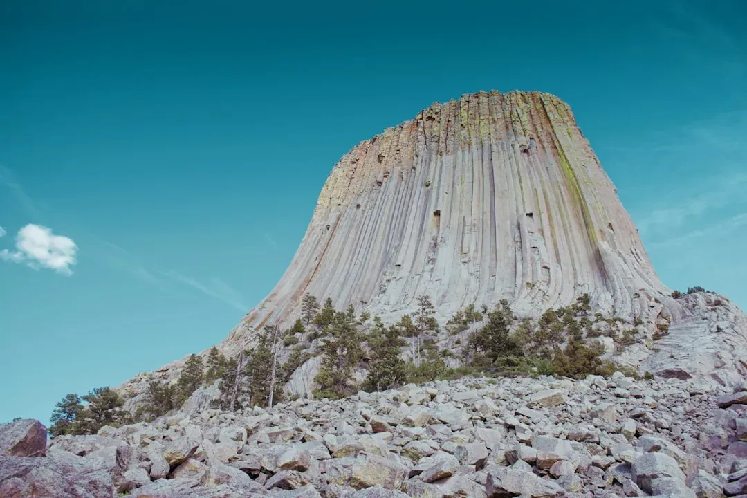
Climbing up into the clouds, it is easy to see why early travelers named this ominous rock stack Devil’s Tower. In fact, it did rise from the fiery depths. Some 66 million years ago, a pool of magma pushed up beneath the sea floor. What you see today is what remained after the softer surrounding rock eroded away over tens of millions of years, leaving this impossibly dramatic column standing alone on the Wyoming plain like a monument built by giants.
Known as “Bear Lodge” by some Native American tribes, this monolithic butte is considered a sacred site. The formation of this giant structure is still debatable, but most geologists consider it to be an igneous intrusion – a formation created by the underground cooling and condensing of magma. Today, it is one of the most popular climbs in the United States. Rising 120 metres above the Wyoming wilderness, the views from the top are breathtaking. Standing beneath it, you realize how trivial anything humans have ever built really is.
9. The Acasta Gneiss, Canada: Earth’s Oldest Exposed Rock
The oldest dated rocks formed on Earth, as an aggregate of minerals that have not been subsequently broken down by erosion or melted, are more than 4 billion years old, formed during the Hadean Eon of Earth’s geological history. In 1999, the oldest known rock on Earth was dated to 4.031 billion years, and is part of the Acasta Gneiss of the Slave Craton in northwestern Canada. Think about that number for a moment. Four billion years. Human civilization is roughly ten thousand years old. You could stack our entire history on top of itself four hundred thousand times and still not equal the age of this rock.
Dating back to the planet’s early history, the oldest known rocks on Earth provide invaluable insights into Earth’s primordial conditions and the geological processes that have shaped the planet over billions of years. Archean rocks are exposed on Earth’s surface in very few places, such as in the geologic shields of Canada, Australia, and Africa. The Acasta Gneiss is not a dramatic vista or a photogenic landscape. It is something far more humbling. It is a piece of the original Earth, a fragment that survived everything the planet could throw at it for over four billion years.
10. The Moeraki Boulders, New Zealand: Mysterious Spheres on the Shore
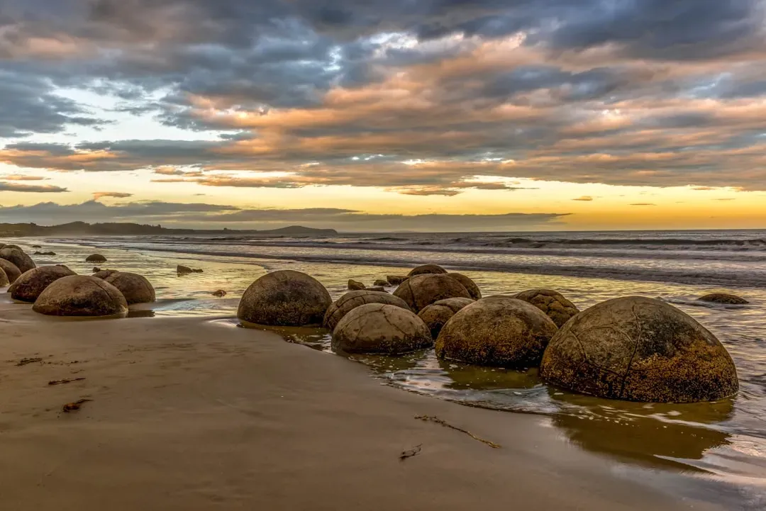
Scattered along Koekohe Beach on the Otago Coast of the South Island, the Moeraki Boulders are large, spherical stones that seem out of place on the sandy shores. These geological curiosities, formed from ancient sea sediments, have fascinated visitors for years with their nearly perfect shapes and mysterious origins. You walk along the beach and suddenly there they are, enormous stone spheres sitting on the sand like dropped cannonballs from some planetary game. Nothing about them looks accidental, even though they are entirely natural.
What makes the Moeraki Boulders particularly fascinating is their size. Some boulders reach up to 3 meters in diameter and weigh several tons. Their spherical forms are a result of natural erosion over time, as the softer mudstone and siltstone surrounding the concretions gradually wore away, leaving behind these giant spherical rocks. They are not only a geological wonder but also carry cultural significance for the local Maori people, who have their own legends and stories associated with these unique formations. In a way, that is the most beautiful thing about geological formations the world over: science and story always seem to find each other at the same remarkable rock.
Conclusion: The Earth Has Been Talking All Along
What is remarkable about all ten of these formations is that they are not passive. They are active narratives, written in stone, waiting for you to slow down and read them. The geological history of Earth follows the major geological events in Earth’s past based on the geologic time scale, a system of chronological measurement based on the study of rock layers. Earth formed approximately 4.54 billion years ago through accretion from the solar nebula. Every formation on this list is a chapter in that colossal story.
I think what strikes me most is how patient geology is. These formations did not rush. They did not perform for anyone. They simply became what they are through time and force and chemistry, and they will continue changing long after we are gone. The Earth is dynamic, consisting of constantly moving plates that are made of rigid continental and oceanic lithosphere overlying a churning, plastically flowing asthenosphere. These plates pull apart, collide, or slide past one another with great force, creating strings of volcanic islands, new ocean floor, earthquakes, and mountains. The next chapter of Earth’s story is already being written beneath your feet right now.
The next time you see a rock formation, whether in a travel photo or in person, pause for just a moment. You are not looking at decoration. You are looking at evidence. Evidence of a planet that has been restless, creative, and violent since its very first day. What would you have guessed was hiding inside these stones?