Our planet is a lot weirder than most of us were taught in school. Beneath the tidy diagrams of tectonic plates and rock cycles, there are places that behave like they missed the memo on how Earth is supposed to work. Scientists have models and theories, sure, but some landscapes still shrug off simple explanations and sit there quietly defying our confidence.
I remember the first time I saw photos of a lake that literally glows blood red from space and thought, this has to be edited. It wasn’t. The more you dig into Earth’s strangest features, the more it feels like the planet is hiding inside jokes in plain sight. Let’s walk through ten geological wonders that experts have studied for decades, yet still can’t fully pin down.
The Devil’s Kettle: Where Does the Water Go?
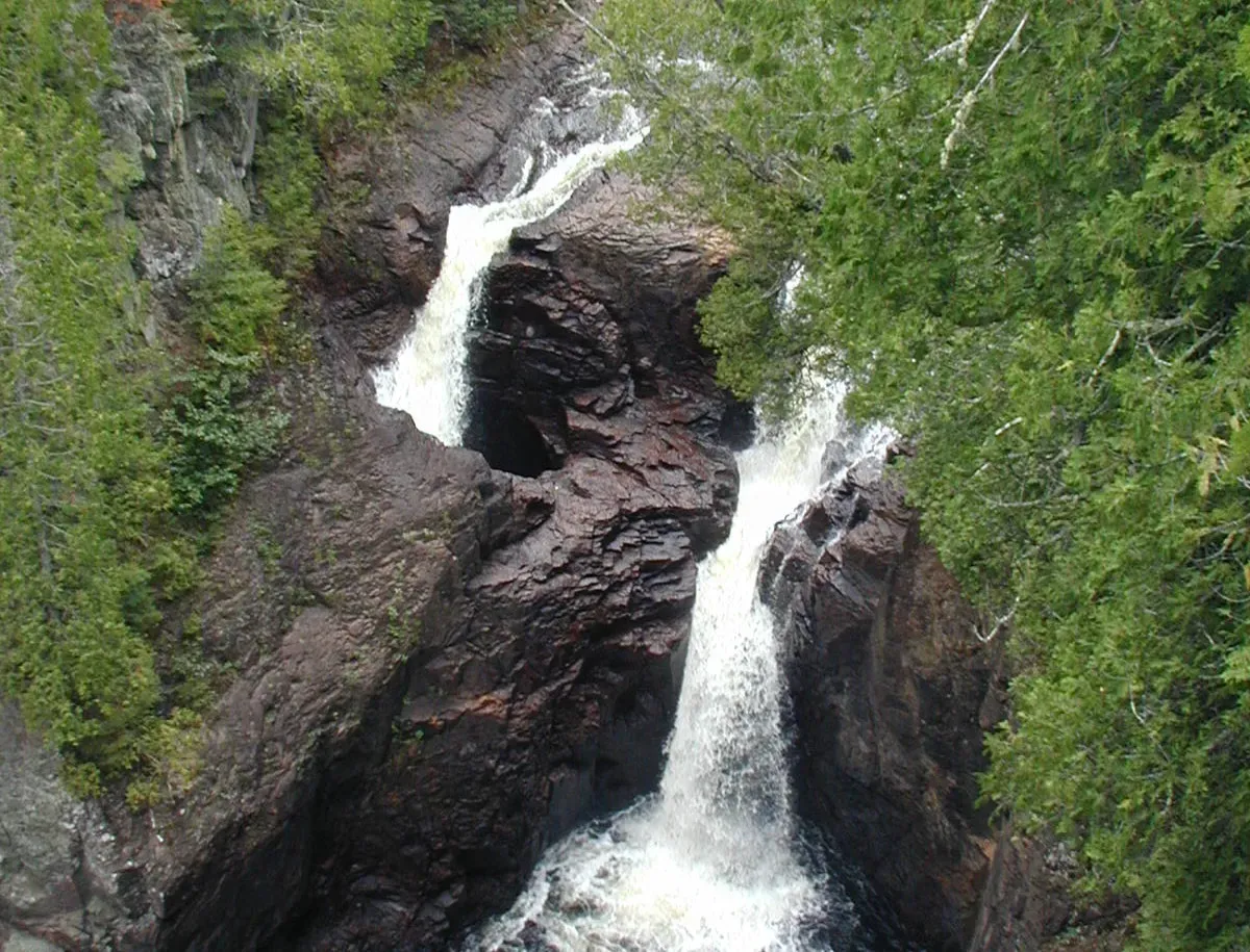
Imagine standing over a roaring river and watching half the water suddenly vanish into a hole in the rock… and never come back. That’s the Devil’s Kettle in Judge C. R. Magney State Park in Minnesota, where the Brule River splits around a rocky outcrop: one branch carries on downstream, the other plunges into a deep pothole and disappears. For years, people tossed in dye, logs, even ping pong balls, waiting to see where the missing water would reappear, but nothing obvious ever showed up.
Geologists are pretty sure the water doesn’t just teleport away, yet no clear outlet has been found at the surface. One leading idea is that the disappearing flow rejoins the river underground through fractured rock, but the exact pathways are still not mapped or directly observed. Part of the mystery is boring but real: it’s incredibly hard and dangerous to physically explore the tight, water-filled channels in solid bedrock. So we’re left with a river that seems to play a magic trick in broad daylight, and the punchline is still mostly guesswork.
The Boiling River of the Amazon: Too Hot for Its Setting
Deep in the Peruvian Amazon, there’s a river that runs so hot it can scald animals alive, with sections reaching temperatures close to boiling. What’s so bizarre is that this kind of extreme heating is usually linked to major volcanic activity, yet the Boiling River, known locally by several Indigenous names, lies far from any large active volcano. It snakes through dense forest, steaming and bubbling like something out of a fever dream rather than a standard geography lesson.
Some researchers think the heat comes from unusually intense geothermal circulation, where rainfall and groundwater plunge deep into the Earth, get superheated, and shoot back up along faults. Others suspect that the local geology is focusing heat in a way we don’t yet fully understand. The exact plumbing system below the river hasn’t been mapped in detail, and drilling in remote rainforest is expensive and disruptive. For now, science can describe what’s happening in rough terms but still can’t offer a neat, fully tested explanation for why this one river is basically a natural slow cooker in the middle of non-volcanic terrain.
Lake Hillier’s Bubble‑Gum Pink Waters
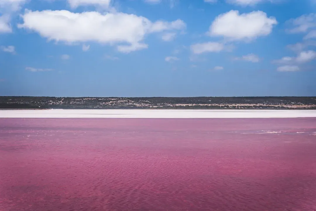
If you’ve ever seen photos of Lake Hillier in Western Australia, it looks fake: a tiny, bubble‑gum pink lake hugging the edge of a dark green island and deep blue ocean. The color doesn’t change when you scoop the water into a container, and it doesn’t vanish with changing seasons either. Scientists know that salty lakes can turn pink due to microbes like certain algae and bacteria that produce reddish pigments, but Lake Hillier’s unwavering solid pink shade is especially intense and oddly stable.
Studies have found pigment‑producing microorganisms and salt‑loving bacteria in the lake, and that certainly explains part of the effect. What’s still not nailed down is how all the interacting factors – microbial communities, extreme salinity, and mineral chemistry – combine to create such a vivid, uniform color that seems almost cartoonish. There may also be subtle mineral contributions from the lake bed or surrounding rocks that aren’t fully quantified. It’s one of those cases where the general mechanism is known, yet the exact recipe behind this particular shade remains more like a guess than a complete formula.
The Sailing Stones of Death Valley
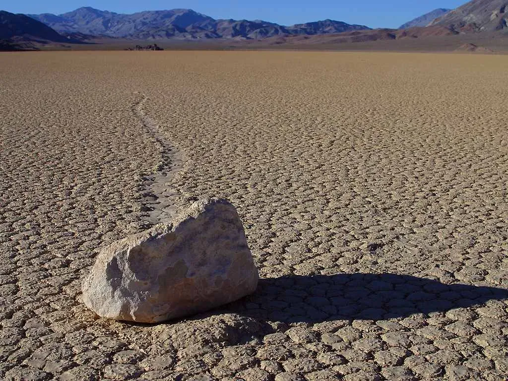
In recent years, time‑lapse cameras and GPS tags have linked the motion to thin sheets of ice forming around the rocks on rare cold, wet nights. As the ice breaks up and a light wind blows, the stones can slide slowly along the slick, softened surface, leaving those eerie trails behind. But there’s still more to understand, from why certain stones move while others sit still, to exactly how subtle differences in mud texture, ice thickness, and wind speed interact. We’ve mostly cracked the “how,” but the fine details of this natural experiment are still being pieced together, like a puzzle that looks finished until you notice some gaps along the edges.
The Door to Hell: A Crater That Refuses to Go Out
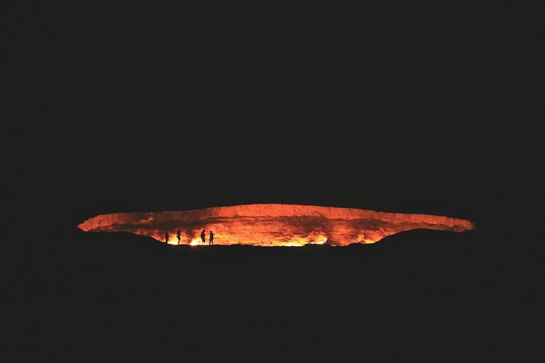
In the Karakum Desert of Turkmenistan, a massive burning crater glows constantly, earning the nickname “Door to Hell.” The Darvaza gas crater started in the early 1970s, when a drilling operation hit a pocket of natural gas and the ground collapsed. To prevent toxic gases from spreading, the gas was ignited, with the expectation that it would burn off in a matter of days. Instead, the flames have been raging for decades, turning the site into a surreal, night‑lit cauldron.
On paper, this is basic geology meets basic chemistry: natural gas leaking from underground reservoirs and catching fire. The mystery lies in how long it has lasted and how complicated the underground system must be to keep feeding the flames. No one has done comprehensive, modern mapping of the full gas field beneath the crater, and official data from the region is scarce. That means scientists can estimate, but not confidently calculate, how much gas remains, how the reservoirs connect, or how long the fire could continue. It’s a man‑made accident sitting on top of natural complexity that we still only dimly understand.
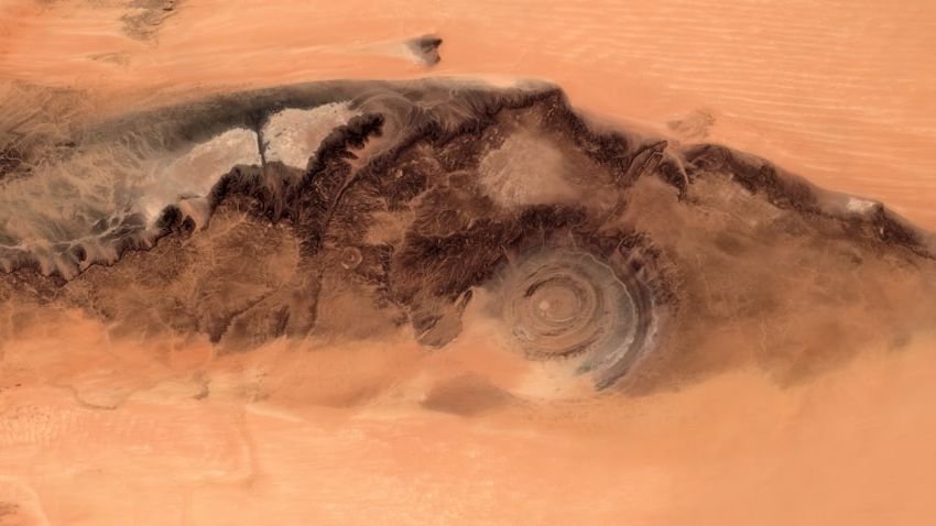
The Richat Structure: A Giant Eye in the Sahara
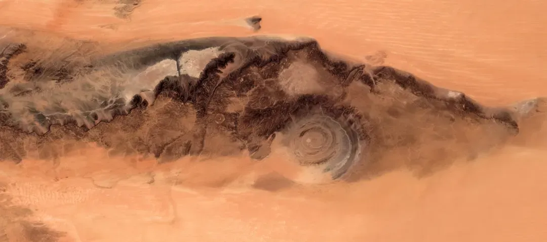
From the ground, the Richat Structure in Mauritania looks like a series of eroded hills and ridges, nothing obviously mind‑bending. But from space, it’s a near‑perfect bullseye: concentric rings spread across tens of kilometers, sometimes called the Eye of the Sahara. Early on, people suspected it might be an impact crater from a massive ancient meteorite, but closer inspections didn’t turn up the right signs of shock and melted rock that big impacts usually leave behind.
The leading interpretation now is that Richat is a deeply eroded dome of rock, pushed up from below by forces within the Earth’s crust and then sculpted by millions of years of weathering. Even with that general idea in place, many details still provoke debate: why is the ring pattern so strikingly regular, and what specific combination of intrusion, uplift, and erosion created this distinctive geometry? The structure is huge, remote, and partly buried under desert sands, which makes getting the kind of detailed sampling and underground imaging scientists would like pretty difficult. So we know the Eye is natural, but we’re still arguing over exactly how the planet drew such a clean target shape in the first place.
Blood Falls in Antarctica: A Glacier That Bleeds Red
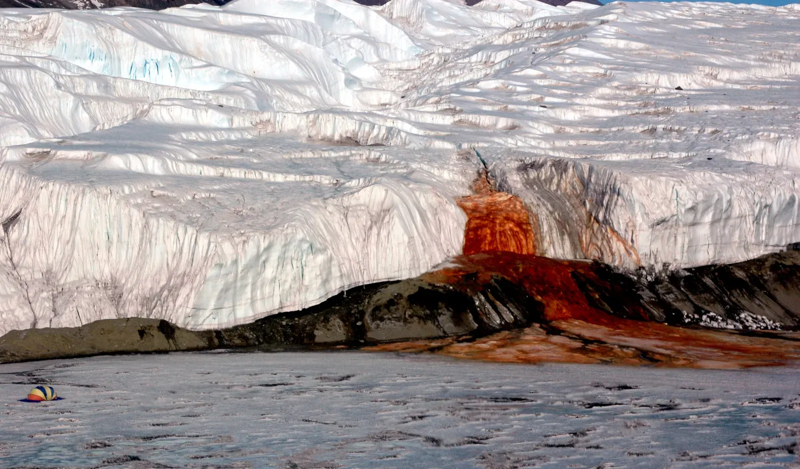
At the edge of Taylor Glacier in Antarctica, a stark white wall of ice appears to ooze rusty‑red water, staining the frozen landscape with something that looks disturbingly like blood. Early explorers thought it was algae, but the color actually comes from iron‑rich, salty water flowing out from deep beneath the glacier. When that briny water hits the air, the iron oxidizes and turns red, much like metal rusting, painting the ice in dramatic streaks.
So what’s the mystery? It’s in the hidden world beneath the glacier – an isolated, dark, super‑salty environment that seems to host tough microbial life and a complex chemical system. Scientists have some data from sampling and remote sensing, but the geometry of the subglacial reservoir, the full history of how it formed, and exactly how microbes and minerals interact there remain uncertain. This odd feature hints at a pocket of Earth that works by rules closer to alien oceans under icy moons than to typical surface lakes. We can point to iron and salt as the reasons for the color, but the full story of why that strange underground brine system even exists still hasn’t been fully written.
Lake Natron: A Mirror of Life and Death
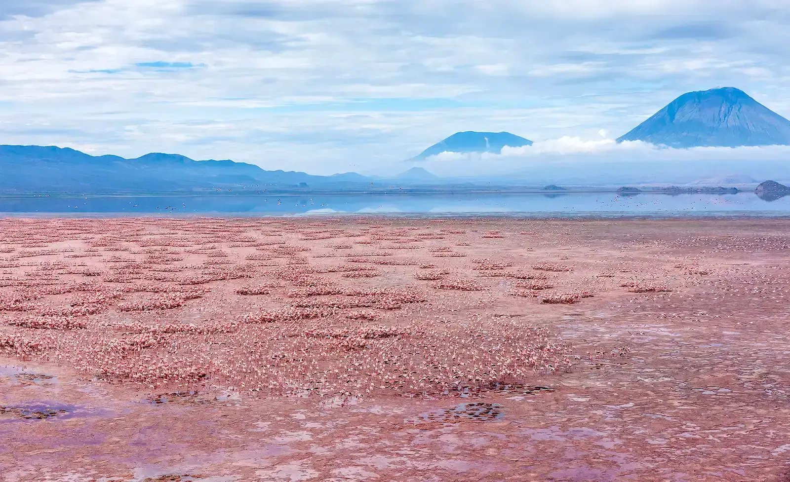
Lake Natron in northern Tanzania looks almost otherworldly from above, with its surface shifting between crimson, orange, and deep purple. The lake is extremely alkaline and can reach high temperatures, creating conditions that are lethal to most animals. Photographers have captured eerie images of birds and other creatures preserved in a statue‑like state along its shores, sometimes appearing as if they were turned to stone. That visual drama has given the lake a reputation as a kind of instant death trap.
The reality is more nuanced, and that’s part of what makes it so fascinating and not fully understood. Certain microorganisms, and even some fish and flamingos, can survive or even thrive in and around this hostile environment. The lake’s chemistry is influenced by volcanic activity, mineral‑rich inflows, and intense evaporation, but the precise balance that allows both deadly conditions and pockets of resilience is still being studied. There are open questions about how stable this environment is over long timescales and how quickly its ecosystems can respond to climate shifts. It’s a place where the line between life and death feels razor‑thin, and the underlying rules are still being decoded.
The Yonaguni Underwater Structure: Nature, Humans, or Both?
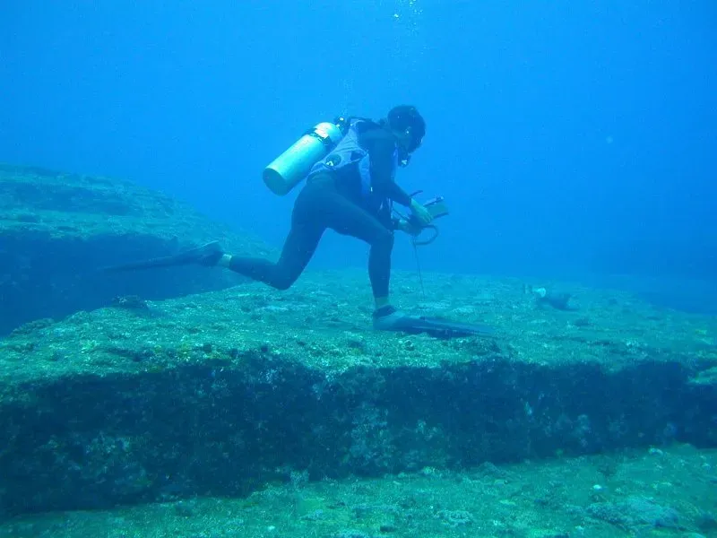
Off the coast of Yonaguni Island in Japan lies a submerged formation that looks suspiciously like a stepped pyramid or a carved terrace complex. Massive stone platforms, flat surfaces, and sharp angles have fueled years of arguments over whether this is a purely natural rock formation, an ancient man‑made structure, or some strange combination of both. Divers describe broad stair‑like features and geometric shapes that don’t easily match the messy randomness people expect from erosion.
Geologists note that sandstone can break and weather along natural joint planes into sharp edges and flat faces, which could explain much of what we see. However, some platforms look so regular that supporters of a human origin argue they must be remnants of a prehistoric site submerged after sea levels rose at the end of the last ice age. The real problem is a lack of definitive evidence: no clear artifacts, no inscriptions, no unambiguous construction marks. Until that kind of proof emerges, the Yonaguni structure will sit in that uncomfortable space where nature and human imagination wrestle, and science can’t yet deliver a final verdict.
The Bermuda Triangle: Vanishing Ships and Puzzling Conditions
The Bermuda Triangle, roughly outlined by Miami, Bermuda, and Puerto Rico, has become legendary as a patch of ocean where planes and ships supposedly vanish under mysterious circumstances. Many of the wilder stories are overblown or simply inaccurate, but there are still some genuinely puzzling incidents in the historical record. The region combines busy shipping lanes, intense weather, powerful currents, and complex undersea terrain, creating a kind of high‑risk laboratory for maritime mishaps.
Researchers have suggested everything from sudden storms and rogue waves to navigation errors and methane gas releases from the seafloor as contributing factors. None of those ideas, on their own, neatly explain every strange account, especially older cases with incomplete data. The area does not consistently show a dramatically higher rate of losses than other heavily traveled ocean zones, yet its reputation persists, fed by gaps in records and a human tendency to see patterns. Scientifically, the Triangle is less a single clear mystery and more a cluster of overlapping uncertainties that still resist being wrapped up into one tidy explanation.
Earth’s Strangest Places Keep Us Honest
Look closely at these ten places and a pattern emerges: science often has a rough outline of what is happening, but the fine print is smudged. A boiling river far from volcanoes, a gas crater that burns for generations, a bright pink lake that refuses to fade – each one highlights how much of Earth’s behavior we still model with approximations and best guesses. It’s humbling in a good way, a reminder that the ground under our feet is not a finished textbook but an ongoing experiment.
There’s something oddly comforting in knowing our planet still keeps secrets in hidden brine pockets, desert eyes, and underwater terraces. It means there are still real discoveries waiting for the next person willing to hike, dive, or camp beside something that doesn’t make full sense yet. Which of these mysteries would you visit first if you had the chance?