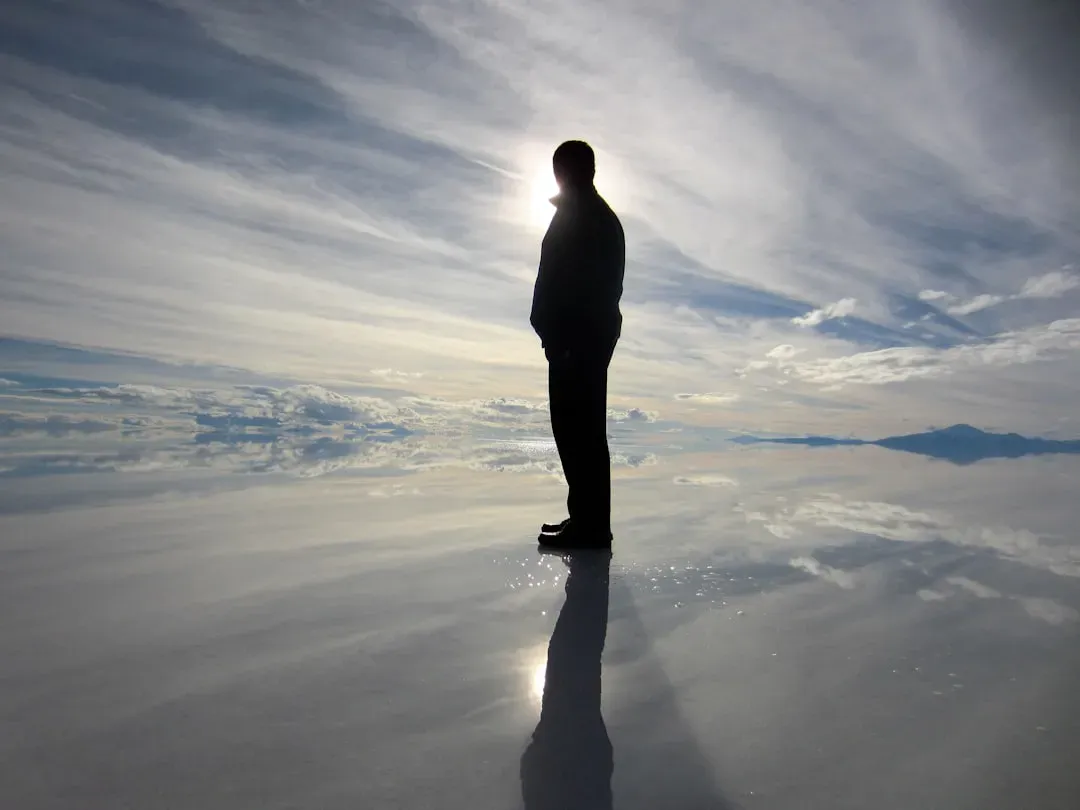
Earth looks solid and settled when you glance out a window, but under that calm surface is a planet still writing its own strange, unfinished story. Some places are so bizarre that even with modern satellites, deep-drilling projects, and sophisticated simulations, scientists still have to shrug and say: we don’t fully know what’s going on here yet.
These formations aren’t just pretty landscapes for postcards. They bend compasses, swallow lakes, warp gravity measurements, and preserve life in ways that seem to defy the normal rules. Below are ten of the most mysterious geological oddities on Earth that continue to raise questions, spark heated debates, and make geologists feel like detectives chasing clues across entire continents.
The Bermuda Triangle’s Deep Seafloor Scars
The Bermuda Triangle is wrapped in legends, but what really intrigues geologists lies far below the ocean surface. High-resolution sonar has revealed steep undersea canyons, odd mounds, and huge scars on the seafloor between Florida, Bermuda, and Puerto Rico that don’t line up neatly with common erosion patterns. Some researchers suggest underwater landslides and shifting sediments may be involved, but the exact processes carving these shapes are still being pieced together.
One leading idea is that massive slope failures triggered by earthquakes or changing ocean currents periodically reshape the seabed here on a colossal scale. Another suspects gas hydrates – ice-like cages of methane in the sediments – might destabilize suddenly, releasing gas and causing collapse. Yet, data are patchy because the area is deep, difficult, and expensive to map in detail. The result is a strange undersea landscape whose full formation history remains frustratingly incomplete.
Mysterious Moving Rocks of Racetrack Playa
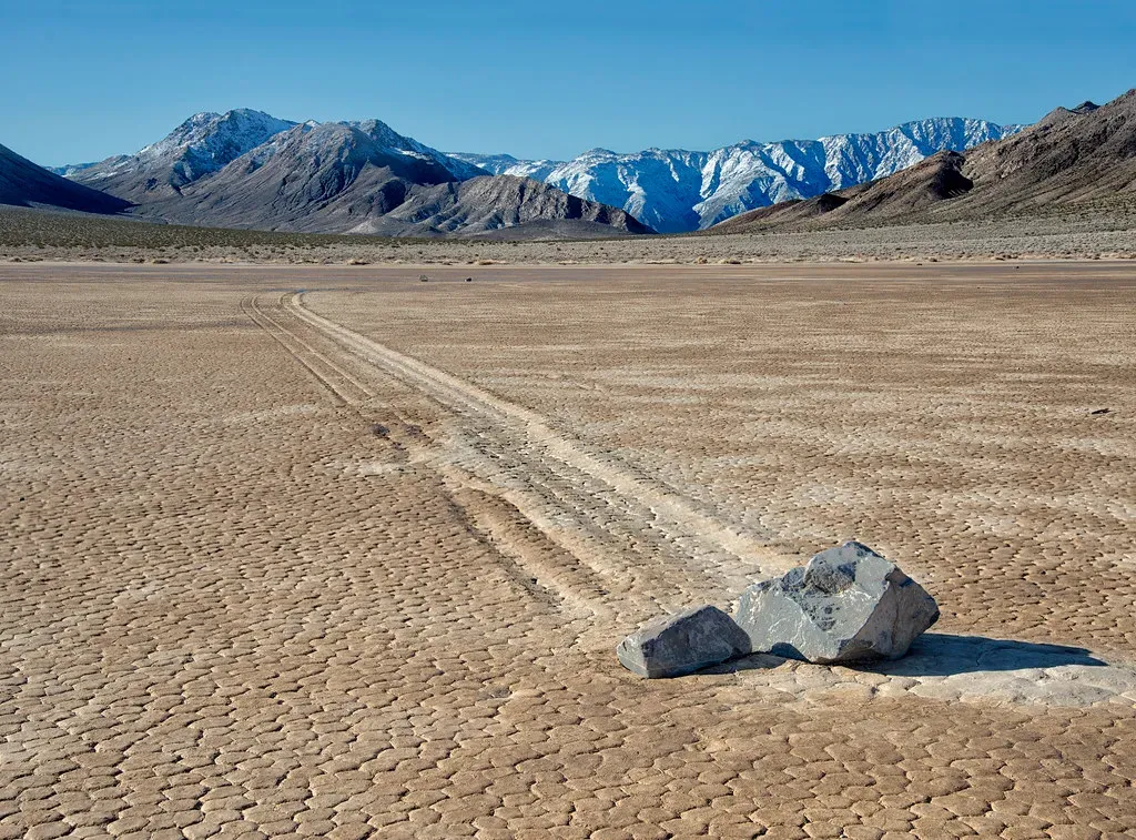
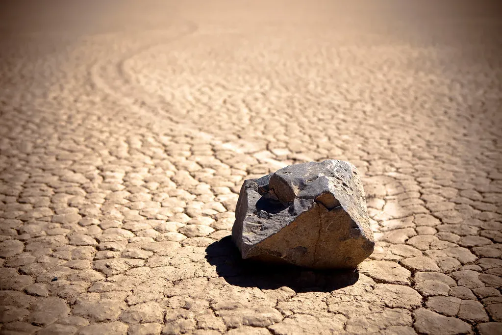
In California’s Death Valley, flat stones wander across a dry lakebed, leaving long, shallow tracks etched into the mud like someone dragged them with invisible strings. For decades, people argued everything from wind and ice to more outlandish explanations, because nobody had actually seen the rocks move in real time. The playa is remote, brutally hot in summer, and often bone dry, so catching the exact conditions was like trying to witness a rare planetary alignment.
Careful field experiments and time-lapse photography eventually showed that thin sheets of winter ice, combined with just the right amount of water and light winds, can nudge the rocks slowly across the surface. But even with this mechanism broadly understood, not every track fits the simple model. Some stones move in one season and then sit still for years, while others change direction abruptly. The physics is mostly explained, yet the fine details of why certain rocks move when neighbors do not keep this formation just mysterious enough to stay on every geology nerd’s bucket list.
Sailing Stones’ Cousins in Other Deserts
What makes things even stranger is that Racetrack Playa isn’t entirely alone. Similar “sailing stone” tracks have been reported, albeit more rarely, in other desert basins in places like Nevada and parts of South America. These sites don’t all share the same climate, altitude, or seasonal pattern, which complicates the idea that one single mechanism is at work everywhere. Some basins show broader, rougher tracks that don’t match the razor-thin scoring at Death Valley.
Scientists suspect a family of similar but not identical processes: sometimes ice and wind, sometimes sticky mud and intense gusts, perhaps occasionally flash flooding. But proper instrumented monitoring is hard to maintain, and a few of these locations are remote or poorly documented. So we’re left with a puzzle: how many ways can a rock “walk” across the Earth’s surface, and are we actually seeing the same phenomenon repeated or several different tricks that just look alike from a distance?
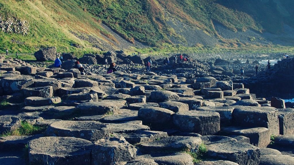
The Hexagonal Columns of Giant’s Causeway
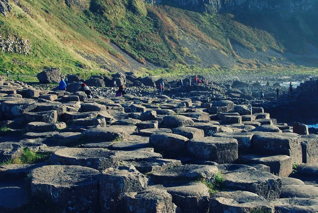
On the coast of Northern Ireland, tens of thousands of basalt columns rise from the sea like neatly stacked pencils. Many of them are near-perfect hexagons, fitting together the way tiles do in a bathroom floor, but on a massive, wild scale. Geologists know that the Giant’s Causeway formed when volcanic lava cooled and cracked, a process similar to how drying mud breaks into polygonal plates. Still, the eerie regularity and massive size of these columns push the explanation into surprisingly complex physics.
Current models suggest that as thick lava cools slowly and evenly, stress builds and fractures propagate downward in a systematic, repeating pattern, favoring hexagons because they distribute energy efficiently. Yet there are still open questions about why certain areas produce almost textbook-perfect columns while others, with apparently similar lava chemistry and cooling conditions, end up with irregular, messy structures. The Causeway sits at that intersection where the general principle is known, but the detailed recipe that made it look this precise is still an active research topic.
Siberia’s Batagaika “Megaslump” Crater
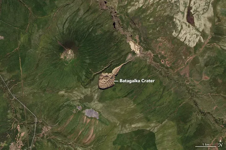
Deep in northeastern Siberia, a giant gash in the ground called the Batagaika crater is widening year after year, like the Earth’s skin unzipping in slow motion. It’s not an impact crater from a meteorite or a volcanic caldera. Instead, it formed when once-frozen permafrost began to thaw and collapse, exposing ancient sediments and ice. The feature is so vast and steep-sided that locals often refer to it as a gateway to the underworld.
What unsettles scientists is not just its dramatic appearance but what it reveals and what it predicts. As the ground slumps and erodes, it exposes layers of frozen soil and preserved biological material that have been locked away for tens of thousands of years, including pollen, bones, and buried forests. At the same time, huge amounts of greenhouse gases can be released from thawing permafrost, feeding back into climate change. Researchers are still trying to understand how quickly structures like Batagaika can expand and whether similar “megaslumps” will appear more commonly across the Arctic in the coming decades.
The Puzzling Sinkholes of the Dead Sea Region
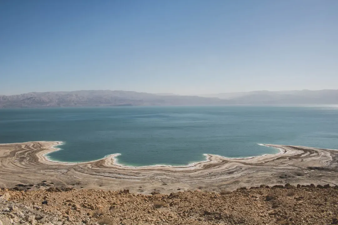
Along the shores of the Dead Sea, new sinkholes have been opening so suddenly that parking lots, date palm groves, and roads have vanished almost overnight. The Dead Sea has been shrinking as water inflow from the Jordan River decreases and evaporation continues, causing groundwater levels to shift. When underground salt layers dissolve, the roof can collapse with little warning, creating deep, nearly vertical pits that look as if the land has been punched from beneath.
Scientists understand the broad trigger – falling water levels and salt dissolution – but the exact locations and timing of each collapse are nearly impossible to predict. Geophysical surveys and ground-penetrating radar help map hidden cavities, yet some sinkholes appear in places that looked stable just months before. This mix of known mechanism and stubborn unpredictability makes the area a living laboratory for understanding karst processes and a stark reminder of how quickly landscapes can rearrange themselves when a key balance is tipped.
The Yonaguni Underwater “Ruins”
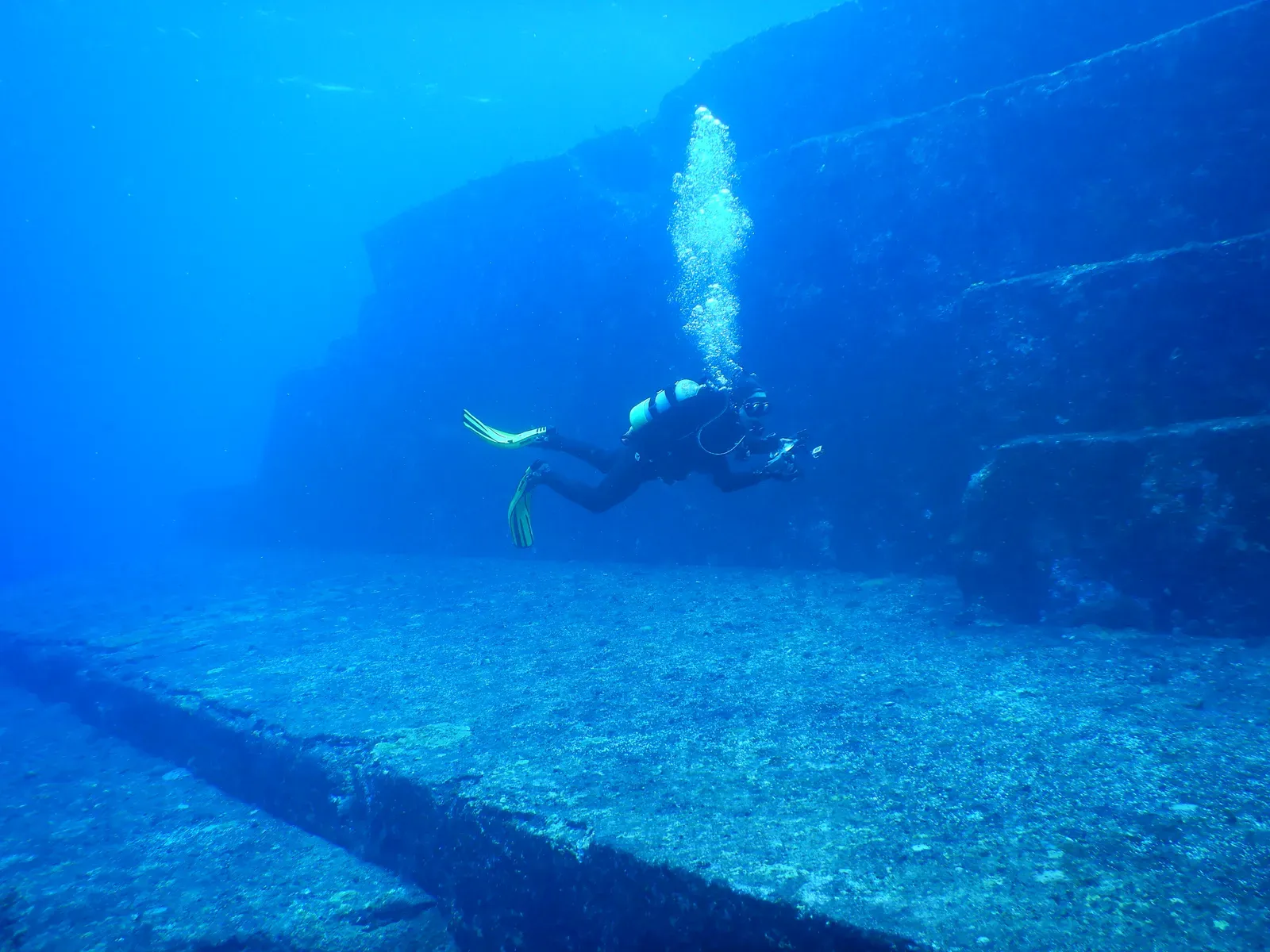
Off the coast of Yonaguni Island in Japan, a series of submerged stone terraces, sharp angles, and seeming staircases have stirred debate for decades. Some divers see the structures and immediately think of lost cities and ancient builders, because it looks uncannily like carved platforms and walls. Geologists point out that many sedimentary rocks naturally fracture into planes and steps, especially under the stress of waves, currents, and earthquakes in tectonically active regions.
The real mystery is not whether every edge is natural or human-made, but how much of the formation is purely geological versus possibly modified by people long ago. Detailed mapping, rock analysis, and comparisons with known natural formations lean strongly toward a natural origin, but the puzzle isn’t fully closed. A few features remain awkward to explain as simple erosion, while the lack of associated artifacts on the scale one would expect from a large settlement keeps the archaeological argument weak. For now, Yonaguni sits at that uneasy boundary where geology and imagination collide.
The Origin of Bolivia’s Salar de Uyuni Mirror
Salar de Uyuni in Bolivia looks like another planet when a thin layer of water turns it into a massive natural mirror. This salt flat is the largest on Earth, the remnant of ancient lakes that once filled a high plateau in the Andes. As those lakes evaporated and retreated over long spans of time, salts and minerals concentrated and crystallized, leaving an almost perfectly smooth, blindingly white expanse that plays tricks with depth perception and horizon lines.
While the broad outline – drying lakes leaving salts behind – is understood, the fine details of why Uyuni is so unnaturally flat and uniform remain a bit of a puzzle. The salt crust seems to self-level, possibly due to cycles of minor flooding, dissolution, and recrystallization, but models struggle to reproduce just how astonishingly even it is across such a huge area. Add to that the massive lithium deposits within its brines and there are still questions about how long this delicate balance between climate, groundwater, and salt chemistry can last before resource extraction or warming shifts it into a different state.
The Gravity-Defying Mascon of Hudson Bay
Satellite measurements show that gravity over Canada’s Hudson Bay region is slightly weaker than in many other parts of Earth. This does not mean things float or that you’d feel a difference walking around, but instruments detect less mass beneath your feet than expected. Part of this anomaly is linked to the ancient Laurentide ice sheet, which once pressed down on the crust and left a long-lasting imprint as it melted away, like a mattress still dented after a heavy weight is removed.
However, post-glacial rebound alone doesn’t fully account for the scale and pattern of the missing mass. Deeper mantle dynamics and variations in rock density beneath the region seem to be involved, but their exact configuration is still under investigation. It’s as if the planet’s underlying “skeleton” has a few bones carved slightly thinner in this area, and scientists are using seismic waves and improved gravity maps to reconstruct what happened over millions of years. The Hudson Bay mascon reminds us that even something as apparently straightforward as gravity can hide messy, ancient stories.
The Endless Blue Hole of Dragon Hole in the South China Sea
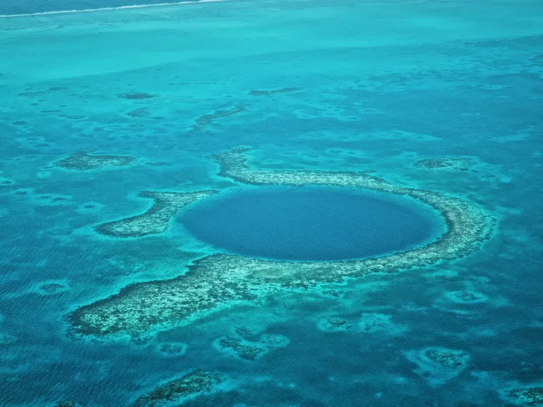
In the South China Sea’s Paracel Islands, the Dragon Hole plunges more than three hundred meters into the ocean, making it one of the deepest known blue holes on Earth. From the surface it looks like a simple round patch of darker water in a coral reef, but divers and sonar scans reveal a cavern that descends into darkness long past recreational diving depths. Blue holes form in limestone when sea levels are lower, and then flood as oceans rise, but each one has its own peculiar shape, chemistry, and internal circulation.
What puzzles researchers about Dragon Hole is how its water layers interact, how oxygen and nutrients move, and what kind of unique microbial ecosystems thrive in the deep, isolated zones. Some measurements hint at sharp transitions where life and chemistry change abruptly with depth, in ways not yet fully explained. Sediments at the bottom might hold clues to past climate and sea-level changes, but reaching and sampling them safely is still a technical challenge. The Dragon Hole is both a geological scar and a vertical archive, and scientists are only starting to decipher the story written in its depths.