You think you know weather. Rain comes from clouds, tornadoes twist across plains, and lightning illuminates stormy skies. Perfectly simple, right? Let me tell you something that might unsettle you. There are weather events so strange, so deeply baffling, that even the brightest scientific minds struggle to explain them.
These aren’t your typical thunderstorms or blizzards. These are phenomena that seem ripped from science fiction novels, yet they’re documented, witnessed, and terrifyingly real. From skies raining fish to tornadoes made of pure flame, nature has a way of keeping us humble. So get ready to question everything you thought you understood about the atmosphere above your head.
When Fish Fall From the Sky Like Drops of Rain
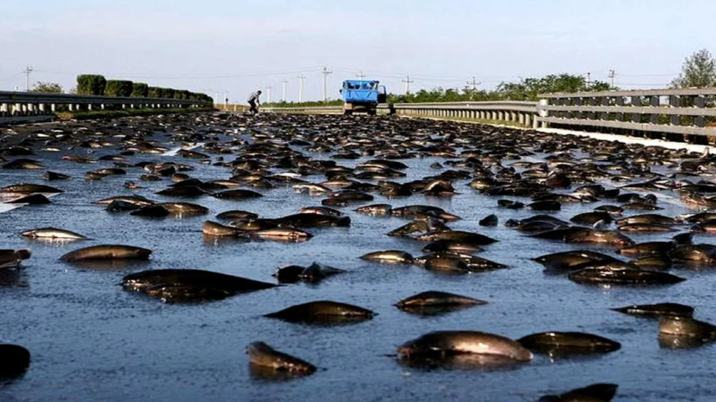
Imagine stepping outside after a storm and finding fish flopping on your driveway. This isn’t fiction; waterspouts can suck aquatic creatures from water bodies and deposit them miles away. In Yoro, Honduras, this phenomenon occurs once or twice a year and has persisted for over a century.
When storm clouds swirl to create tornado-like columns over bodies of water, they can sweep up small animals. The fish get pulled into the vortex, carried along with the storm system, then dumped over land as the waterspout loses energy. Such rains of creatures have been reported worldwide.
What makes this truly bizarre? In Honduras, the fish aren’t local to the area and may originate from the Atlantic Ocean about 72 kilometers away. Scientists remain puzzled about certain details, like why the animals are often alive when they land, having survived being hurled through the atmosphere at tremendous speeds.
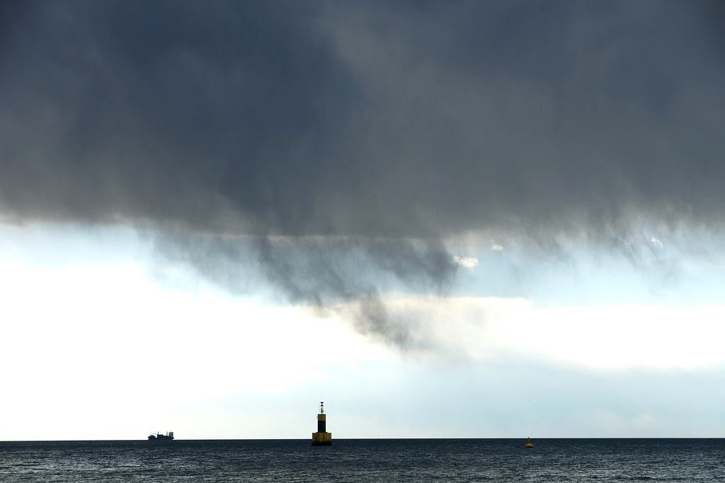
Blood Rain That Stained Everything Crimson

In 2001, the southern Indian state of Kerala experienced rainfall that appeared red, startling local populations. For weeks, the crimson showers fell, staining homes and terrifying residents who wondered if the apocalypse had arrived. This wasn’t biblical punishment, though the explanation remains partially mysterious.
Researchers found that this unusual rain is stained either by dust from deserts or by microscopic algae suspended in raindrops. However, scientists aren’t entirely sure how algae get into clouds, and they couldn’t initially find DNA matches for the substance. Some researchers even hypothesized the material might have alien origins, hitching a ride on a meteor.
Eventually, scientists matched the DNA to a common red algae species. Still, the mystery of how such massive quantities reached the upper atmosphere persists. It’s hard to say for sure, but the event reminds us how little we truly understand about what happens above the clouds.
Ball Lightning: The Floating Orb of Electrical Terror
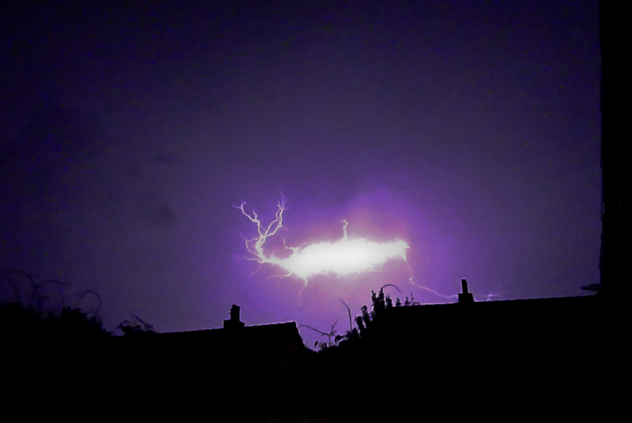
Ball lightning appears during thunderstorms, often indoors, and may even explode, leaving scientists scratching their heads despite eyewitness accounts swearing it’s real and terrifying. The bizarre phenomenon usually appears as a floating sphere ranging in color from blue to orange to yellow, disappearing within seconds.
There is presently no widely accepted explanation for ball lightning, though several hypotheses have been advanced since the phenomenon entered scientific investigation in the 1840s. One theory suggests ball lightning results from ground strikes creating reactions between oxygen and vaporized soil elements, producing ionized air or plasma.
What makes ball lightning particularly unnerving is its unpredictability. It has been described as moving in unpredictable trajectories, hovering, and being attracted to, unaffected by, or repelled from buildings, people, and cars. Historical accounts describe it killing people and entering buildings through closed windows. Honestly, it sounds like nature’s most ominous magic trick.
Fire Tornadoes That Turn Wildfires Into Hell on Earth
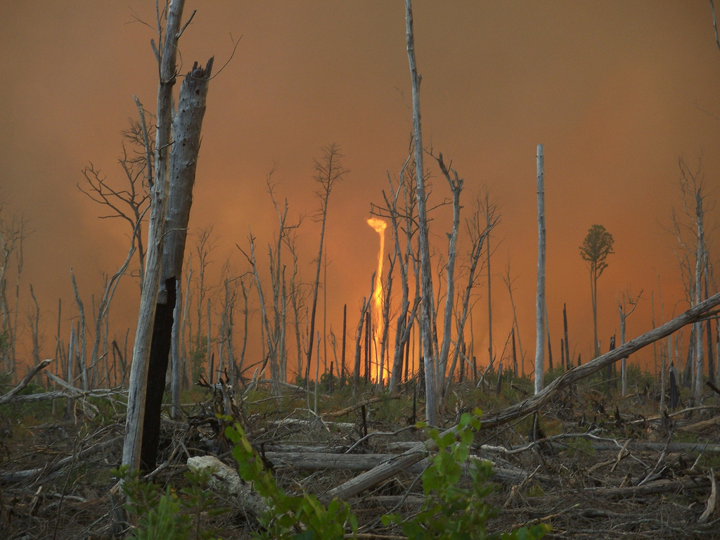
In July 2018, a wildfire near Redding, California, produced a fire tornado with winds equivalent to an EF3 tornado, astonishing meteorologists nationwide. These vortices can last an hour or more, with temperatures inside reaching over 1,000 degrees.
Fire tornadoes are not actual tornadoes but vortices that suck in gases and combustible materials, most common in large-scale wildfires. They’re cyclones generated by forest fires due to heat and thermodynamic effects, requiring enormous fires so hot they create their own weather systems. The sheer intensity vaporizes moisture from burning trees, which gets sucked into the upper atmosphere.
Prior to the Carr Fire event, there had never been a tornado-caused fatality in California’s modern history except for one caused by another fire-related twister in 1926, making the 2018 fire tornado one of the most anomalous weather events in modern U.S. history. These fiery vortexes represent nature at its most destructive and terrifying.
Thundersnow: When Winter Storms Go Electric

Lightning flashing and thunder roaring in the middle of a snowstorm sounds like a weather anomaly dreamed up by a rock band; thundersnow is rare, dramatic, and incredibly loud, like a blizzard mixed with a thunderstorm. It’s the kind of event that makes you question reality when you witness it.
Thundersnow is most common in the Great Lakes region of the United States, occurring about two to three times per year. The phenomenon requires specific conditions where strong vertical motion in the atmosphere coincides with heavy snowfall. The electrical discharge happens just like in regular thunderstorms, but surrounded by falling snow instead of rain.
What makes thundersnow particularly startling is the acoustics. Snow dampens sound waves, so when thunder does boom, it’s typically much quieter and travels shorter distances than summer thunder. When you hear it clearly during a blizzard, you know you’re experiencing something genuinely unusual.
Heat Bursts That Make Midnight Feel Like Midday
Imagine waking at midnight to find the temperature has shot up 20 degrees in minutes and 80 mph wind gusts have ravaged your town; though rare, that’s the power of a heat burst. These bizarre events occur in the wake of dying thunderstorms when conditions align perfectly.
Heat bursts happen when storms high in the atmosphere rain into hot, dry air beneath; evaporation takes heat energy from surrounding air, causing it to cool and contract into a dense parcel too heavy to stay aloft, which then falls rapidly. As this air descends, it compresses and heats dramatically, sometimes raising temperatures by astonishing amounts.
During one Montana chinook event, locations in Montana have seen dramatic temperature rises of tens of degrees in mere hours. The destructive winds and sudden heat can damage buildings and leave communities bewildered by the overnight transformation.
Asperitas Clouds: The Sky Turned Upside Down
Asperitas is a relatively rare but distinctive wave-like cloud formation, best described as looking at a rough sea from below the surface; it was officially named by the World Meteorological Organization in March 2017, making it the first new cloud type added to the International Cloud Atlas in 66 years.
These clouds look genuinely apocalyptic. Asperitas is characterized by well-defined, wave-like structures in the underside of a cloud, sometimes descending into sharp points. Scientists still don’t fully understand how they form, but formation may result from interaction between updrafts and downdrafts within storms.
The clouds appear mostly harmless despite their menacing appearance. They often precede or follow thunderstorms, creating dramatic photo opportunities for weather enthusiasts. Yet the fact that meteorologists only recently classified them officially shows how much we’re still discovering about atmospheric phenomena right above our heads.
Mammatus Clouds: Nature’s Bubble Wrap in the Sky
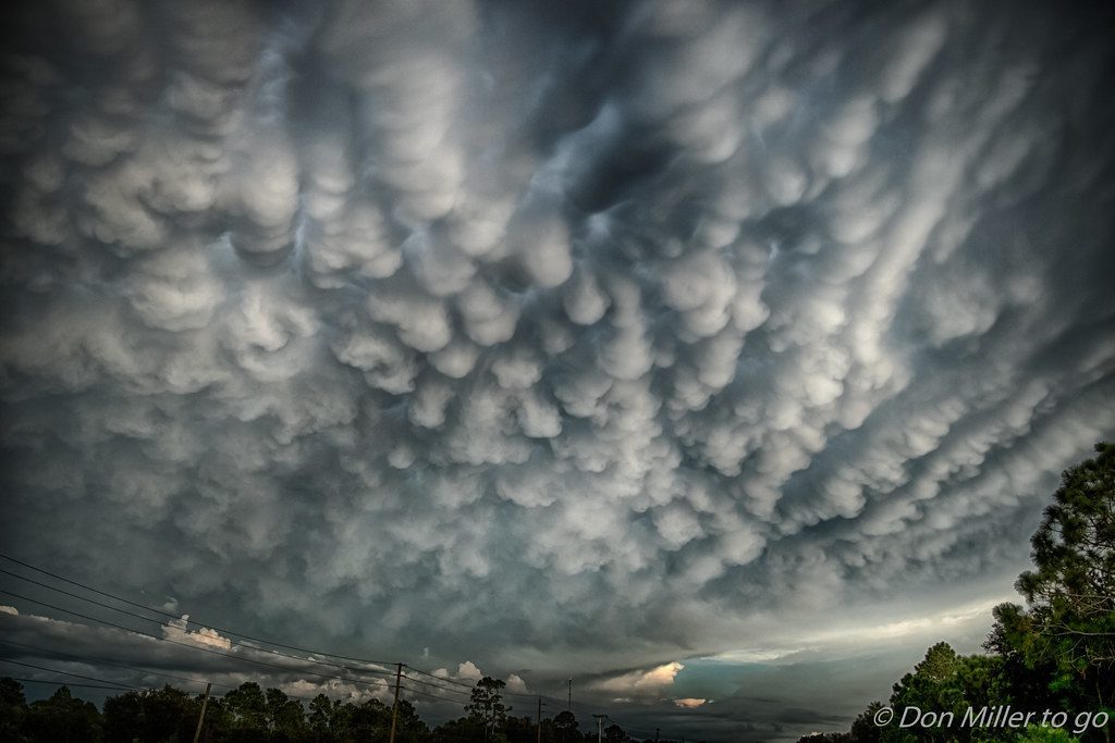
Mammatus clouds resemble huge bubble wrap stuck to the cloud base, typically smooth on the bottom with a more textured appearance on top, forming when cold, sinking air pockets push the cloud base, causing it to bulge and create distinctive pouch-like shapes.
They often appear during or after thunderstorms, and while they look menacing, they’re mostly harmless. The name comes from the Latin word for udder, which accurately describes their sagging, rounded appearance. These formations can cover vast areas of sky, creating surreal landscapes that seem more suited to alien planets than Earth.
What’s fascinating is that despite their relatively common occurrence compared to other rare phenomena, meteorologists still debate the exact mechanisms of their formation. The interaction between rising and sinking air masses creates these pocket formations, but the specifics remain partially mysterious.
Virga: Ghost Rain That Never Touches Ground
Virga is ghostly precipitation that never reaches the ground; when air beneath a cloud is very dry, precipitation falling through it evaporates before reaching Earth’s surface, leaving feathery streaks extending from the cloud’s base. It’s rain you can see but never feel.
Virga is a sign of dry air preventing powerful clouds with large heavy raindrops from forming, creating stunning visual effects as rain falls through the air, with the cloud itself thinning out and slowly dissipating as if it has fallen from the sky.
The phenomenon is relatively common in arid regions but startles people unfamiliar with it. You’ll watch dark storm clouds overhead with clear rain shafts descending, yet the ground remains bone dry. It’s a reminder that even something as simple as rain depends on precise atmospheric conditions to complete its journey.
Ice Tsunamis: When Frozen Lakes Invade Land
Ice tsunamis happen when strong winds push massive sheets of ice from lakes onto shorelines; these icy behemoths crush trees, fences, and anything else in their path. It’s nature’s cold-hearted version of a beach invasion, moving with slow, inevitable destruction.
The largest ice shove on record occurred on Lake Ontario, with ice moving more than 30 meters inland. These events typically occur in late winter or early spring when ice begins breaking apart but remains thick enough to maintain structural integrity. Strong winds then pile the ice sheets against shorelines, creating walls that can reach several meters high.
Residents living near affected areas describe the sound as terrifying: grinding, cracking, and crashing as tons of ice bulldoze everything in their path. The slow-motion disaster gives people time to evacuate but leaves property devastation in its wake. It’s one of those phenomena that seems impossible until you witness the destruction firsthand.
The Mystery Deepens: What This Means for Our Understanding

These ten bizarre weather anomalies represent just a fraction of the atmospheric mysteries still puzzling scientists. From fish raining down like manna from heaven to ice walls invading shorelines, nature consistently proves it has tricks we’ve barely begun to understand. The atmosphere operates on such complex scales, with so many interacting variables, that predicting or even explaining these rare events remains extraordinarily difficult.
Here’s the thing: as climate patterns shift and extreme weather becomes more common, we might see some of these phenomena occur more frequently. Fire tornadoes are becoming better documented as wildfire seasons intensify. Ball lightning sightings increase as more people carry cameras everywhere. The mysterious becomes slightly less mysterious, yet plenty of questions remain unanswered.
What surprises me most is how many of these events were dismissed as folklore or exaggeration until modern documentation proved them real. It makes you wonder what other “impossible” weather phenomena might actually exist, waiting for the right conditions and the right observer to bring them into scientific acceptance. Did any of these leave you speechless? What would you do if you witnessed fish falling from your sky or saw a glowing orb of electricity floating through your living room?