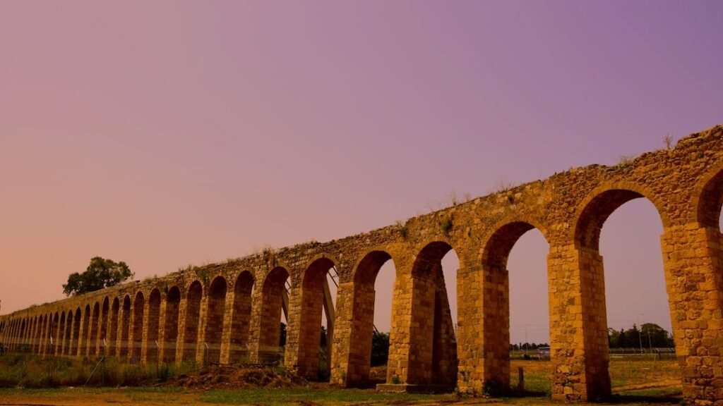
Stonehenge gets the headlines, but across the Americas, ancient Native builders raised earth, stone, and even shell into forms so precise and so biologically attuned to the landscape that modern researchers are still catching up. Many of these sites were engineered not just as monuments, but as living instruments: tracking the Sun and Moon, reshaping rivers, concentrating wildlife, and even altering local ecosystems in ways we’re only beginning to appreciate. Archaeologists, ecologists, and Indigenous knowledge keepers are now uncovering how these places tapped into animal behavior, seasonal migrations, and plant cycles with uncanny accuracy. The result is a radically different picture of “prehistory,” one where humans and nonhuman nature were tightly coupled in subtle feedback loops. And as new lidar scans, ancient DNA, and soil microbiology studies roll in, one question keeps growing louder: how much science did we lose when we dismissed these structures as mere “mounds” in the dirt?
The Hidden Clues at Serpent Mound, Ohio
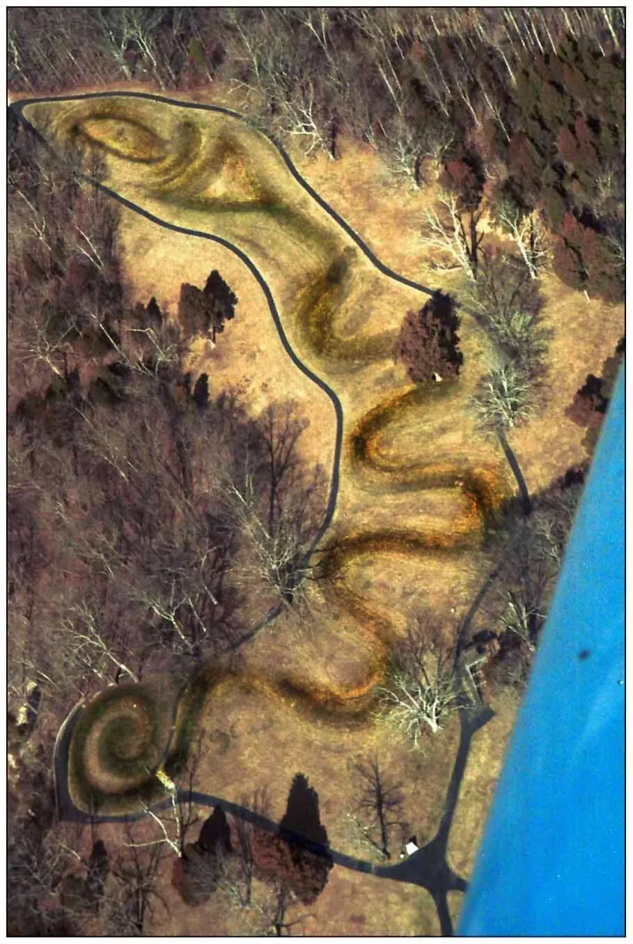
At first glance, the Great Serpent Mound in southern Ohio looks like a dramatic work of art: a sinuous earthen snake uncoiling across a ridge, its head seemingly swallowing an egg-shaped mound. But archaeologists now think this thousand-foot-long effigy is also a sophisticated observatory, keyed to solar and possibly lunar events with astonishing precision. The serpent’s coils and head align with key moments in the solar year, including the summer solstice sunset, suggesting that its builders carefully tracked the Sun’s path over long periods. That alignment likely wasn’t just spiritual symbolism; it would also have marked shifts in animal behavior, such as insect emergence, nesting cycles, and fish spawning runs tied to temperature and day length. In other words, Serpent Mound may encode a calendar of biological rhythms, not just dates on an abstract cosmic clock.
Standing there myself a few years ago, I remember how quiet the place felt, except for birds and the wind, and it struck me that this “calendar” would have been most useful when the landscape itself was loud with life. Knowing exactly when the solstice arrived meant knowing when certain plants were ready to harvest or when particular species of migratory birds could be expected to return. This type of knowledge would have given communities a predictive edge in managing hunting pressure, planting, and ceremonial cycles, especially in ecosystems where small timing errors spell real risk. Today, ecologists talk about “phenology,” the study of seasonal biological timing; Serpent Mound shows that Native scientists were phenologists long before the word existed.
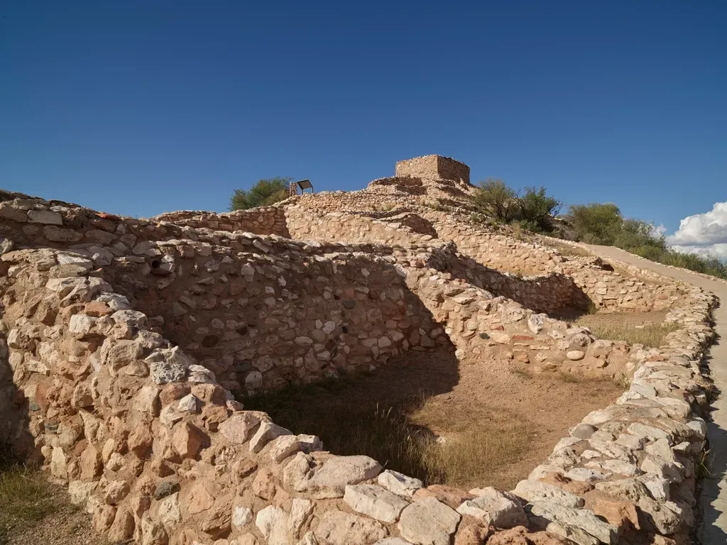
Cahokia’s Monk’s Mound: An Earthwork City Tuned to Life Cycles
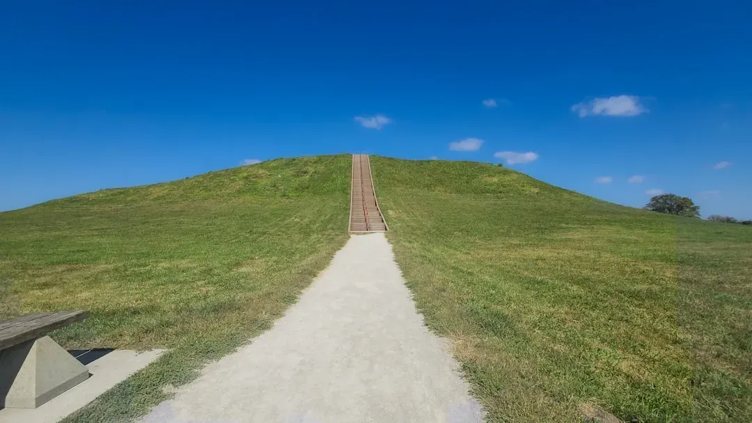
Near present-day St. Louis, the ancient city of Cahokia once had a skyline dominated not by stone towers but by earthen pyramids, the largest of which is known as Monk’s Mound. This massive platform, built from millions of basket-loads of soil, was the centerpiece of a metropolis that may have rivaled or exceeded major European cities around the year 1100. While much attention goes to its political and religious role, a growing body of research suggests Cahokia was also embedded in a deliberately engineered landscape of wetlands, fields, and woodlands. The surrounding bottomlands of the Mississippi floodplain were rich with fish, migratory waterfowl, mussels, and fertile soils, all of which respond strongly to flooding cycles and seasonal river pulses.
By building elevated platforms and residential zones above flood level, Cahokia’s people buffered themselves against extreme water events while still exploiting flood-driven fertility in nearby fields. Archaeobotanical evidence indicates they cultivated crops like maize alongside native plants such as sumpweed and goosefoot, which are sensitive to planting windows and moisture regimes. When you look at Monk’s Mound in that context, it becomes less a mysterious monument and more a command post over a biologically dynamic, semi-managed ecosystem. The city’s success depended on reading the river’s mood, anticipating fish movements, and timing planting around flood recession, an ecological balancing act that modern river managers still struggle to pull off.
Poverty Point, Louisiana: Ridgelines of Trade, Migration, and Marsh Life
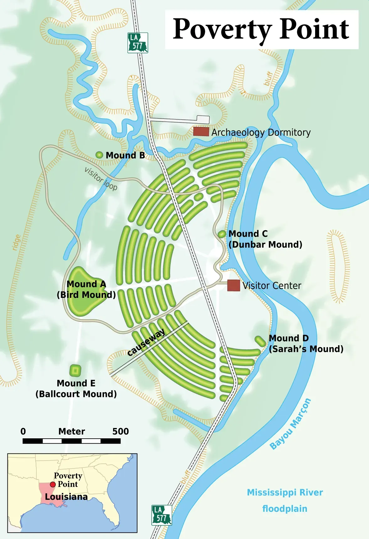
Poverty Point, in northeastern Louisiana, is older than many Egyptian pyramids, yet it rarely makes school textbooks. From above, the site’s C-shaped earthen ridges and mounds look like the imprint of a massive fingerprint pressed into the landscape. Archaeologists now know it was a hub in a vast trade network stretching over hundreds of miles, with stone tools and raw materials arriving from as far as the Appalachians and the Midwest river valleys. That network was sustained across a wetland-rich environment, where fish, waterbirds, shellfish, and floodplain mammals moved along seasonal routes that mirrored human travel and exchange. In this sense, the site sat at the intersection of not just trade routes, but migration pathways of countless nonhuman species.
The ridges themselves likely hosted domestic spaces, gardens, and activity areas built just above the swampier ground, giving residents direct access to marsh resources without constantly battling floodwaters. From a biological perspective, this is smart design: instead of draining wetlands, the builders perched on the edges of productive ecological engines. Modern conservation science has finally caught up to the idea that intact wetlands protect biodiversity, buffer storms, and support fisheries; Poverty Point’s layout reads like an early version of that playbook. The site also hints that people understood how changes in water levels ripple through food webs, from plankton to fish to birds, and built their lives around these pulsing cycles rather than trying to override them.
Chaco Canyon’s Great Houses: Skies, Seasons, and Animal Highways
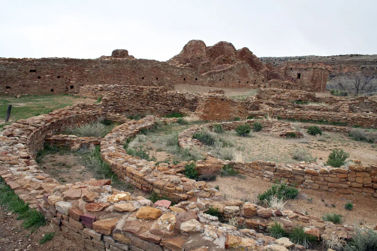
In the stark desert of what is now northwestern New Mexico, the monumental “great houses” of Chaco Canyon rise in semi-ruin – multistory complexes linked by roads that slice arrow-straight across mesas. At first, those roads were seen mostly as ceremonial or political statements, but researchers increasingly suspect they were also tied to seasonal movements of people and resources, including game, timber, and agricultural products. The canyon itself sits in a mosaic of habitats: upland forests, grasslands, and riparian zones, each with its own cast of animals that move in response to rainfall, temperature, and plant growth. Chaco’s residents leveraged these differences by building storage, observation points, and perhaps even signaling systems along routes that overlapped with wildlife corridors.
The great houses are famously aligned with astronomical events, including solstices and major lunar standstills, and those celestial markers would have been tightly linked to biological events on the ground. For example, in arid environments, the timing of monsoon rains can make or break crops and drive insect booms that cascade into bird and small mammal populations. Being able to anchor communal activities to predictable sky events offered an anchor in a landscape that otherwise feels highly variable year to year. In a way, Chaco’s architects were hacking environmental uncertainty with a combination of star knowledge, landscape engineering, and an intuitive grasp of animal and plant responses to climate pulses.
Earthworks of the Amazon: Hidden Cities in the Green Ocean
For decades, the Amazon rainforest was portrayed as a pristine wilderness, lightly touched by humans, but aerial surveys and soil studies have shattered that myth. Beneath the canopy, especially along ancient river courses and seasonal floodplains, archaeologists are finding geometric earthworks, causeways, and settlement grids that point to complex societies managing forests and wetlands at large scales. These structures often sit in or near patches of unusually dark, fertile soil known as Amazonian dark earth, which is rich in charcoal, nutrients, and microbial life. Such soils suggest deliberate long-term management of plant growth, organic waste, and fire, effectively creating hotspots of fertility and biodiversity. Animals – from insects and earthworms up to birds and primates – respond strongly to these patches, concentrating around them and shaping seed dispersal patterns.
What makes these Amazonian earthworks so mysterious is how seamlessly they appear to blend into living ecosystems rather than dominating them. Instead of massive stone temples, we see ditches, embankments, and engineered forest mosaics that subtly nudge where water flows, how floodwaters spread, and which tree species thrive. That, in turn, influences which animals frequent the area, turning human-made structures into long-term experiments in ecosystem tuning. As ecologists now study how these ancient interventions still influence forest composition, it raises the startling possibility that large parts of the “wild” Amazon are, in fact, human-shaped biological artifacts. The line between natural and artificial blurs, suggesting a form of engineering that works with evolutionary processes rather than against them.
Shell Rings of the Southeast: Living with Tides and Estuaries
Along the coasts of what are now South Carolina, Georgia, and Florida, circular and horseshoe-shaped shell rings rise quietly among live oaks and marsh grasses. These formations, built from layer upon layer of discarded oyster, clam, and other shellfish, were long dismissed as trash heaps. Recent work paints a more intricate picture: communities here may have intentionally built ringed settlements that tuned social life to tidal rhythms and estuarine biology. Shell growth depends on salinity, temperature, and nutrient flows, all of which respond to seasons, storms, and freshwater input. By living quite literally on rings of accumulated shell, people were embedding themselves in the life cycle of the estuary.
Analyses of shell size and age suggest careful harvesting strategies that avoided taking too many juveniles, supporting long-term productivity. The rings also changed the microtopography, raising living spaces slightly above the marsh and creating new niches for plants and small animals that prefer drier or more alkaline soils. From a biological standpoint, these structures turned waste into architecture and habitat, with cascading effects up the food chain. In a time when modern coastal cities struggle with erosion and sea-level rise, the shell rings look like an early, low-tech template for resilient coastal design that respects, rather than fights, the tidal pulse.
Why These Structures Matter for Science Today
It is tempting to treat these ancient sites as isolated wonders, but together they tell a consistent story about how humans can live with, and not just on top of, complex ecosystems. Unlike many industrial-era projects that try to dominate landscapes with dams, straightened rivers, or clearcuts, these Native structures often work by amplifying or redirecting natural processes. They track the Sun and Moon to predict animal migrations, harness floodwaters rather than simply walling them off, and turn waste materials into habitat-building infrastructure. In modern terms, they look less like monuments and more like prototypes of climate-smart, biodiversity-aware design. When we compare them with rigid modern infrastructure, the older systems often look more adaptive and less brittle.
That contrast matters because today’s environmental problems – climate change, mass extinction, soil loss – are partly the result of ignoring biological feedbacks. The ancient architects behind Cahokia, Serpent Mound, or the Amazonian earthworks did not have satellite data or climate models, but they had long-term observation, careful trial and error, and cultural memory. Their structures encode hypotheses about how rivers respond to floods, how forests recover after disturbance, and how animal populations rebound or crash under different pressures. Treating these sites as laboratories, rather than relics, opens up fresh lines of inquiry into resilience and sustainability. In an age when scientists are racing to develop nature-based solutions, the oldest working examples may already be waiting in the ground.
From Ancient Tools to Modern Ecological Science
The technical “toolkit” used to build many Native American structures seems humble – baskets, digging sticks, stone tools – but the conceptual toolkit was anything but. Designing Monk’s Mound or a shell ring meant understanding soil behavior, compaction, and drainage well enough that the structures would last for centuries without collapsing. It also required modeling, however intuitively, the ways plants and animals would respond to subtle changes in topography and hydrology. Today’s earth scientists use instruments to measure erosion rates and soil moisture; ancient builders used patient observation and generational knowledge passed through stories, ritual, and practice. The result is a form of engineering that looks closer to ecology than to modern civil engineering textbooks.
Modern researchers are starting to meet that knowledge halfway with new technologies. Lidar scanning reveals buried earthworks under forests, drone mapping traces ancient canals through wetlands, and isotopic analysis of bones and seeds reconstructs past diets and migrations. When these tools are combined with Indigenous perspectives, a new narrative emerges: these were not peripheral cultures dabbling in agriculture, but advanced landscape managers who manipulated food webs in subtle, often reversible ways. Rather than permanent concrete, they used earth, wood, shell, and fire, materials that interact with the biosphere instead of sealing it off. It is an approach that feels unexpectedly aligned with present-day calls for regenerative agriculture and ecosystem restoration.
The Future Landscape: Learning from Deep-Time Experiments
Looking ahead, these ancient structures may influence how we design cities, farms, and protected areas in a warming world. Their long-term endurance offers real-world experiments in what works over centuries, not just decades, when it comes to soil stability, water management, and biodiversity support. Engineers and planners are already borrowing ideas from Indigenous water harvesting techniques, fire regimes, and agroforestry; large earthworks and shell constructions point to further possibilities. Imagine flood-prone towns that sit on raised earthen terraces modeled after Cahokia, or coastal defenses that double as shellfish habitats, echoing the Southeastern shell rings. These ideas are not romantic fantasies – they are practical, historically tested responses to environmental variability.
At the same time, integrating this knowledge faces real challenges. Many sites are threatened by erosion, development, and looting, erasing data before it can be studied. There are also ethical questions about who controls research narratives and how benefits are shared with descendant communities. If scientists treat these landscapes only as sources of raw data, they risk repeating the same extractive patterns that damaged them in the first place. The most promising path forward pairs cutting-edge technology with Indigenous-led research and stewardship, treating ancient earthworks as partners in designing a more resilient future rather than as curiosities from a vanished past.
Global Perspectives on Ancient Bio-Engineering
Although this story centers on Native American structures, it sits within a broader global pattern of ancient ecological engineering. Terraced fields in the Andes, fishponds in the Pacific, and rice terraces in Asia all show humans learning to cooperate with biological productivity rather than simply exploiting it. What stands out about the American examples is how often they were overlooked or minimized, in part because they were made of perishable materials like earth and shell instead of enduring stone. When compared directly with something like Stonehenge, these structures may appear less imposing, but their ecological sophistication is staggering. They are, in a sense, quieter technologies – less visible, more interwoven with soil microbes, birds, insects, and water flows.
That humility makes them especially relevant in a century defined by planetary limits. While modern megaprojects chase visibility and scale, ancient earthworks remind us that influence can be subtle, distributed, and deeply biological. A raised ridge here, a redirected channel there, and suddenly fish runs improve, crops stabilize, and erosion slows. Scaling such interventions today will require both scientific rigor and cultural humility, recognizing that knowledge about living systems has long existed outside formal laboratories. These sites challenge us to think of infrastructure not just as steel and concrete, but as deliberate arrangements of life itself.
How Readers Can Engage with Living Ancient Landscapes
For most of us, the first step in engaging with these places is simply to recognize that they are there and that they are still active participants in local ecosystems. Visiting a site like Serpent Mound, Cahokia, or a coastal shell ring is not just a history field trip; it is a chance to watch how birds use the structures, how plants cluster along their slopes, how water pools or drains in patterned ways. Supporting local tribes, site stewards, and community organizations that manage these landscapes helps ensure that research and tourism unfold on their terms. That might mean donating to preservation efforts, attending guided tours that center Indigenous voices, or advocating for legal protections when development threatens to erase the past. Even reading site reports and sharing stories about these places reframes them as part of our collective scientific heritage, not just regional curiosities.
On a more personal level, these structures invite us to pay closer attention to the living systems around our own homes. You do not need a thousand-foot serpent effigy to notice when the first pollinators appear in spring or which birds follow particular flowering trees. Thinking like the engineers of Cahokia or Poverty Point means asking how small changes to land use – planting native species, restoring wetlands, reducing hard surfaces – might ripple through local food webs. It is a mindset shift from seeing nature as backdrop to seeing it as collaborator. In that sense, the most mysterious thing about these ancient Native American structures might not be how they were built, but how they continue to teach us, if we are willing to listen.

Suhail Ahmed is a passionate digital professional and nature enthusiast with over 8 years of experience in content strategy, SEO, web development, and digital operations. Alongside his freelance journey, Suhail actively contributes to nature and wildlife platforms like Discover Wildlife, where he channels his curiosity for the planet into engaging, educational storytelling.
With a strong background in managing digital ecosystems — from ecommerce stores and WordPress websites to social media and automation — Suhail merges technical precision with creative insight. His content reflects a rare balance: SEO-friendly yet deeply human, data-informed yet emotionally resonant.
Driven by a love for discovery and storytelling, Suhail believes in using digital platforms to amplify causes that matter — especially those protecting Earth’s biodiversity and inspiring sustainable living. Whether he’s managing online projects or crafting wildlife content, his goal remains the same: to inform, inspire, and leave a positive digital footprint.